|
ROCKY MOUNTAIN
Mountaineering in the Rocky Mountain National Park |

|
MOUNTAINEERING IN THE ROCKY MOUNTAIN
NATIONAL PARK.
PART 1.—SUGGESTIONS, NOTES, AND INFORMATION.
The word mountaineer suggests to many persons one who has acquired proficiency in scaling almost inaccessible peaks. It is here used in a much more general sense, and is intended to include all those who find pleasure and benefit from visits to mountainous areas and who have made, or wish to make, more intimate friendships with mountains and peaks. The number of such mountaineers is legion.
The Rocky Mountain National Park and the areas adjoining it offer many inducements to mountain lovers. The accessibility of the area puts it within the reach of thousands. Accommodation is offered to suit all varieties of taste and purse. The peaks vary from low timbered hills up to the barren summits of the high peaks; the loftiest is Longs Peak, 14,255 feet above sea level. Most of the mountains are easy of access or have at least one route that presents no difficulties. A few of the summits may be reached on horseback. On the other hand, the climber who delights in steep and difficult routes will find unlimited possibilities awaiting him, for many of the peaks have one or more sides that are precipitous and from these sides the peaks are difficult if not impossible of access.
The scenery is greatly diversified. One finds large areas of forest, tall superb pines, spruce and fir; interspersed in the forests are flat, open, grassy meadows, and higher up one finds vast plateaus above timberline with a variety of plant life, and then come barren fields of rocks, almost devoid of life, and then great rugged peaks, bristling with crags and walled by precipices.
The life history of a river is clearly written. From the lower edge of a snow field comes a small trickle; farther down among the rocks other rivulets join it and it grows and grows; laughing and leaping it plunges down the valley, over waterfalls, through wooded valleys, lapping the roots of trees, refreshing the flowers on the bank, furnishing a home for the darting trout and forming an important factor in most plant and animal life. Strung along the stream, like jewels on a necklace, are the mirrored lakes, large and small, catching the reflection of sky and cloud, peak and forest. As the stream winds its way unfalteringly down the valley it joins more and still more of its kind, and by the time the lower valleys are reached a river is formed, and with a last salute to its parental hills it starts on its mission to the world beyond.
|
|
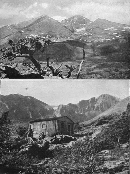
PLATE III. LONGS PEAK FROM TILE TWIN SISTERS,
LOOKING ACROSS TAHOSA VALLEY. The peaks from left to right are Mount Meeker, Longs Peak, and Mount Lady Washington. TIMBERLINE CABIN. Photograph by Wiswall Brothers. |
The national park is a sanctuary to animal lite. There are few places in the country where one has a better chance to see the Bighorn, or mountain sheep, in his chosen home; coyotes sing nightly serenades, and smaller animals such as woodchucks, squirrels, and chipmunks are frequently seen. Many animals live in the region, but keep very successfully away from visitors, who see only their footprints or their handiwork. Deer, black bear, mountain lions, bobcats and beaver are present, but rarely seen.
Bird life is plentiful and many varieties are found, as one passes through the various zones from the valleys to the peaks.
The wealth of wild flowers is a cause of constant delight and one does not have to be a botanist to love and appreciate them. In all seasons, and in all localities, they welcome the visitor. Hundreds and hundreds of varieties and a profusion of blossoms border the trails and bedeck the hillsides.
When one considers the use and the development of the mountainous areas of other countries, it is surprising that those of our own country have not created more interest. It is certain that a much greater number of American tourists will be drawn to this gigantic wilderness of lofty peaks, steep snow fields, glaciers, romantic valleys and gorges, frozen lakes and precipices as soon as the beauty of the ever-changing scenery is more widely known and when the facilities for the tourists are further increased.
THE ROCKY MOUNTAIN NATIONAL PARK.
The Rocky Mountain National Park was created by act of Congress, January 26, 1915, and enlarged by a subsequent act of Congress, February 14, 1917. It has an area of 398 square miles, or about 255,000 acres. It includes about 29 miles of the Continental Divide and large areas on both the Atlantic and Pacific slopes. It includes parts of Larimer, Boulder, and Grand Counties.
It is under the control and supervision of the National Park Service, Department of the Interior. The local administration is carried on by a superintendent and a number of park rangers. The address of the superintendent is Estes Park, Colo.
The department has issued certain desirable rules and regulations for the government of the park, which relate to the protection of animal and plant life, regulation of camping, care of fires and prevention of forest fires, prohibition of firearms within the park, careful use of automobiles and similar subjects. The regulations are not made at all burdensome to anyone who wishes to use the park in ordinary ways and with due regard to the rights of others.
|
|
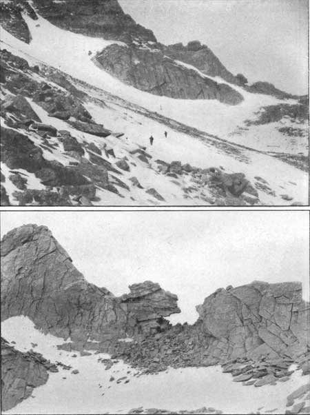
PLATE IV. BOULDER FIELD AND THE KEYHOLE. Photograph by G. H. Harvey, jr. THE KEYHOLE. Photograph by Clark Blickensderfer. LONGS PEAK TRAIL. |
Copies of the rules and regulations, a circular of general information, published each year, and additional information and literature may be obtained upon request from the superintendent of the park or from the National Park Service, Washington, D. C.
SHELTER CABINS.
There are several shelter cabins in the Rocky Mountain National Park. One is on Fall River, southwest of Mount Chapin. A second cabin is at Poudre Lakes, near Milner Pass, on the trail from Fall River to Grand Lake. A third cabin is on the North Inlet trail from Grand Lake to Flattop Mountain. A fourth cabin is on the Cache la Poudre River near the north boundary line of the national park.
These cabins have camp stoves or fireplaces. Each has some cooking equipment. They are maintained by the National Park Service for use by the public, and are intended to provide shelter in time of need. They are not intended to be used as permanent camps, and all persons desiring shelter have equal rights to them. Parties using these cabins should take particular care to leave them clean and in good condition, for the next party. The prospector's motto "Keep the woodbox full or the fire out" applies here.
RANGER STATIONS.
The Mill Creek Ranger Station is on the Flattop trail; the Pole Creek Ranger Station is about 3 miles south of Grand Lake. Another ranger station is a mile northwest of Longs Peak Inn at the base of Estes Cone. These are the homes of the rangers, who are glad to extend assistance or courtesies to visitors.
EMERGENCY TELEPHONES.
Telephone lines extend between Estes Park and Grand Lake, along the Flattop trail and also along the Fall River road and trail. Telephones will be found at 5-mile intervals along these lines for use by the public in cases of emergency.
NATIONAL FORESTS.
The timbered areas adjacent to and outside of the national park are under the supervision and control of the United States Forest Service, which, in turn, is under the direction of the Secretary of Agriculture. For convenience of administration, the timbered portions of a State are divided into separate forests, each with a supervisor in charge and forest rangers as assistants. Part of the Medicine Bow Range, the country around Monarch Lake, and in general most of the land in the area under consideration lying on the western slope (not included in the national park) is in the Arapaho National Forest, while that on the eastern slope (not included in the national park) is in the Colorado National Forest.
Information regarding the regulations and management of the land under the control of the Forest Service can be obtained from the forest supervisors, or from the district forester's office in Denver, or from the United States Forest Service, Washington, D. C.
HOW TO REACH THE ROCKY MOUNTAIN NATIONAL
PARK.
The Rocky Mountain National Park is naturally approached through Denver. Four railroads, the Colorado & Southern, the Chicago, Burlington & Quincy, the Union Pacific, and the Denver, Boulder & Western, carry passengers to points convenient of access by automobile stage to Estes Park village, the eastern gateway. The Colorado & Southern has stations at Loveland, Longmont, and Fort Collins; the Chicago, Burlington & Quincy stops at Loveland, Longmont, Lyons, and Fort Collins; the Union Pacific stops at Fort Collins; the Denver, Boulder & Western stops at Ward. The west side of the park is reached from Denver by way of Granby, on the Denver & Salt Lake Railroad; from Granby stages run to Grand Lake, the western gateway.
Automobile stages cover 33 miles from Loveland to Estes Park, 35 miles from Longmont to Estes Park, 23 miles from Lyons to Estes Park, 32 miles from Ward to Estes Park, and 44 miles from Fort Collins to Estes Park; the fare is the same by all routes. From Estes Park visitors reach their various destinations by hotel and transportation bus or private conveyance.
The automobile run from Denver to Estes Park is 70 or 80 miles, according to the route chosen. The run will take from four to six hours.
The Rocky Mountain Parks Transportation Co. operates the auto stage lines to Estes Park from Denver, Ward, Longmont, Lyons, Loveland, and Fort Collins, and handles both passengers and freight.
The automobile portion of all routes to Estes Park are full of scenic beauty and variety of interest. Whether one goes by. public or private conveyance, it is recommended that a circle trip be made, going in by one route and returning by another. For example, one may reach the park via Loveland, and thence by auto up the rugged canyon of the Big Thompson, and then make the return trip via the shorter "hill road" to Lyons.
|
| PLATE V. MAP OF ROCKY MOUNTAIN NATIONAL PARK. Note: Numbers on the map indicate the locations of the resorts and hotels bearing corresponding numbers, listed on page 105. (click on image for an enlargement in a new window) |
The route that gives the most varied and closest views of the mountain peaks is the one via Ward, and is known as "The Switzerland Trail of America." Another good route is to go to Lyons and thence up the canyon of the South St. Vrain River, via Allens Park to Copeland Lodge, to Longs Peak Inn, and to Estes Park village. The regular stages do not run on this route, as it is 10 miles or more longer than the "Lyons Hill road," but it is a very beautiful and scenic route. In fact, every route has its peculiar charm and attraction.
There are good garages at the railroad towns referred to above (except Ward).
|
| FIG. 1.—Map showing railroad routes to Rocky Mountain and Mesa Verde National Parks. |
ONE-DAY TRIPS.
Camping out is not an essential feature of mountain climbing in this region. One can usually reach the top of one or more of the nearer peaks and return to the hotel the same day. For example, from the hotels at the foot of Longs Peak one may climb Longs Peak in a day, though it is rather a long trip. One may also climb Mount Meeker or, more easily still, the Twin Sisters or Estes Cone. Starting from Estes Park, with an automobile, one may reach some peak of the Mummy Range and return the same day. A variety of one-day trips may be made from the lodge at Lawn Lake. Spragues Hotel is a good starting point, and several peaks may be reached in one day trips from there. Timberline Cabin, on Longs Peak, greatly facilitates this climb by offering a suitable shelter for the night as high up on the peak as firewood is available. Fern Lake Lodge is beautifully located on the trail leading from Moraine Park up to Fern and Odessa Lakes. Several first-class climbs to high peaks of the Continental Divide can be made in one day from this delightful starting point.
With a little planning, and the occasional use of horses or an automobile, a party can take many one-day trips from Estes Park that are full of interest and variety. This is also true of most of the other starting points in this region.
The construction of Government-built mountain shelters can and doubtless will be continued. These cabins will simplify the problem of camping out, since at least a shelter and a stove will be provided, which will make possible trips with light packs. The problem of bedding, however, is not so easily solved. It is hardly practicable to equip such shelter cabins with bedding. Blankets are expensive in the first cost, and they might be carried off. Furthermore, no one has yet devised a bed that is suitable for repeated and frequent use without the care of an attendant.
The reluctance of most visitors to undertake any trip requiring a night spent in the open, accounts, more than any other one thing, for the unfrequented and unvisited regions of our national park and similar mountain areas of the State.
SUGGESTED SCHEDULE OF TRIPS.
The following itinerary is suggested for those that wish to avail themselves of hotel accommodations and avoid the necessity of camping out.
First. Climb Longs Peak. Start from one of the hotels at the foot of the peak and spend the night at Timberline Cabin. Arrange for a guide to go with you, or at least to meet you there the following morning. Climb the peak on the second day and return to your hotel that night.
Second. Take horses for a three to five day trip; the first day go up the Fall River road and trail and over to Poudre Lakes. Here make a detour to the so-called crater on the west side of Specimen Mountain. If an early start is made from Estes Park, and not too much time is spent at Specimen Mountain, you can reach Squeaky Bob's camp for the night. The Specimen Mountain trip can be made from Squeaky Bob's in a day if you find the trip across the range sufficient for the first day. The following day, ride down to Grand Lake in the morning, and spend the afternoon boating and fishing. The following day ride up to North Inlet trail, over Flattop Mountain and back into Estes Park. This horseback trip can be done in three days, but an extra day or two should be allowed in case of bad weather or for some detour you may wish to make.
Third. Go to Fern Lake and climb Stones Peak or visit some of the small but beautiful lakes in the vicinity.
Fourth. Go to one of the hotels in Horseshoe Park and on to the lodge at Lawn Lake and spend a day or two visiting Hallett Glacier and the Mummy Range.
Fifth. Go to Copeland Lake Lodge or Allens Park and climb Meadow Mountain, which is not a high peak, but a good viewpoint.
Sixth. From Stapps Hotel climb Mount Audubon, then cross over Buchanan Pass to Monarch Lake. From here, return across the divide at Arapaho Pass, spend the night at Fourth of July Mines, and then climb the two Arapaho Peaks.
The above schedule covers the entire region in a general way and provides sufficient occupation for several weeks. It may be changed to meet the individual preferences; some parts may be omitted and others extended.
If you have a camping outfit and wish to spend a few nights in the open, some of the less accessible parts of the region may be visited.
CONTOUR MAP.
Accompanying this publication is a map (Web Edition Note: this map has been omitted from the online edition) of the Rocky Mountain National Park. This map covers the Longs Peak and a strip from the southern part of the Home Quadrangle maps published and for sale by the United States Geological Survey.
The scale of the map is approximately 2 miles to an inch. It is printed in four colors; the cultural features, such as roads, trails, towns, and buildings, as well as the lettering, are in black; the water features, such as streams and lakes, are in blue; the features of relief, such as mountains and valleys, are shown by brown contour lines, marked with the elevation above sea level. The contour interval is 100 feet. Roads, trails, shelter cabins, and ranger stations are emphasized by a red overprint.
The descriptions in this book refer frequently to this map, and the same nomenclature is followed. The map is based on plane-table surveys, made by triangulation from many peaks and other observation points. Contours and details are sketched in between points whose location and elevation are known. One should not expect absolute accuracy in all details, but in general the map is a trustworthy guide and is of such great value that it is indispensable to climbers and should always be carried on a trip.
The Longs Peak and Home Quadrangle maps may be obtained from the superintendent at Estes Park and from stationers in Denver for 10 cents each. They may be mounted on cloth and dissected so as to fold conveniently and compactly, for about 50 cents per copy. The mounted map is recommended if it is to he used on many trips.
NAMES OF PEAKS EXCEEDING 11,000 FEET IN ALTITUDE.
Named peaks (exceeding 11,000 feet in altitude) on the Longs Peak quadrangle in order of elevation.
(NOTE.—In the following list, the location of the peak is given showing whether it is on the Continental Divide or on the Atlantic or Pacific slope.]
| No. | Peak. | Elevation in feet. | Location. |
| 1 | Longs Peak | 14,255 | Atlantic. |
| 2 | Mount Meeker | 13,911 | Do. |
| 3 | Chiefs Head | 13,579 | Do. |
| 4 | Hagues Peak | 13,562 | Do. |
| 5 | Ypsilon Mountain | 13,507 | Do. |
| 6 | Arapaho Peak | 13,506 | Divide. |
| 7 | Mount Fairchild | 13,502 | Atlantic. |
| 8 | Pagoda | 13,491 | Do. |
| 9 | Mummy Mountain | 13,413 | Do. |
| 10 | Navajo Peak | 13,406 | Divide. |
| 11 | Storm Peak | 13,335 | Atlantic. |
| 12 | Mount Alice | 13,319 | Divide. |
| 13 | McHenrys Peak | 13,300 | Do. |
| 14 | Mount Lady Washington | 13,269 | Atlantic. |
| 15 | Mount Audubon | 13,223 | Do. |
| 16 | Mount Copeland | 13,176 | Do. |
| 17 | Taylor Peak | 13,150 | Divide. |
| 18 | Arikaree Peak | 13,147 | Do. |
| 19 | Ogalalla | 13,147 | Do. |
| 20 | Kiowa Peak | 13,501 | Atlantic. |
| 21 | Paiute Peak | 13,082 | Divide. |
| 22 | Mount Chiquita | 13,052 | Atlantic. |
| 23 | Mount Richthofen | 12,953 | Divide. |
| 24 | Stones Peak | 12,928 | Atlantic. |
| 25 | Mount Julian | 12,928 | Do. |
| 26 | Pawnee Peak | 12,900 | Divide. |
| 27 | Howard Mountain | 12,814 | Do. |
| 28 | Apache Peak | 12,807 | Pacific. |
| 29 | Mount Cirrus | 12,804 | Divide. |
| 30 | Mount Neva | 12,800 | Do. |
| 31 | Mount Nimbus | 12,730 | Pacific. |
| 32 | Hallett Peak | 12,725 | Divide. |
| 33 | Mount Cumulus | 12,724 | Do. |
| 34 | Mount Ida | 12,700 | Do. |
| 35 | Terra Tomah Peak | 12,686 | Atlantic. |
| 36 | Mount Achonee | 12,656 | Pacific. |
| 37 | Mahana Peak | 12,629 | Atlantic. |
| 38 | Thatchtop | 12,600 | Do. |
| 39 | Ouzel Peak | 12,600 | Divide. |
| 40 | Mount Albion | 12,596 | Atlantic. |
| 41 | Andrews Peak | 12,564 | Pacific. |
| 42 | Mount Dunraven | 12,548 | Atlantic. |
| 43 | Bowen Mountain | 12,541 | Pacific. |
| 44 | Lead Mountain | 12,532 | Divide. |
| 45 | Specimen Mountain | 12,482 | Do. |
| 46 | Otis Peak | 12,478 | Do. |
| 47 | Mount Chapin | 12,458 | Atlantic. |
| 48 | Tanima Peak | 12,417 | Do. |
| 49 | Baker Mountain | 12,406 | Pacific. |
| 50 | Nokhi Crags | 12,400 | Atlantic. |
| 51 | Parika Peak | 12,400 | Divide. |
| 52 | Trail Ridge | 12,400 | Atlantic. |
| 53 | Hiamovi Mountain | 12,388 | Pacific. |
| 54 | Watanga Mountain | 12,381 | Do. |
| 55 | Cascade Mountain | 12,350 | Do. |
| 56 | Sawtooth Mountain | 12,304 | Divide. |
| 57 | Platte Mountain | 12,300 | Pacific. |
| 58 | Snowdrift Peak | 12,280 | Do. |
| 59 | Nakai Peak | 12,221 | Do. |
| 60 | Mount St. Vrain | 12,162 | Atlantic. |
| 61 | Mount Adams | 12,115 | Pacific. |
| 62 | Mount Craig | 12,005 | Do. |
| 63 | Thunderbolt Peak | 11,943 | Do. |
| 64 | Battle Mountain | 11,930 | Atlantic. |
| 65 | Satanta Peak | 11,885 | Pacific. |
| 66 | Mount Dickinson | 11,874 | Atlantic. |
| 67 | Mount Bennay | 11,781 | Pacific. |
| 68 | Mount Irving Hale | 11,747 | Do. |
| 69 | Bearpaws Peaks | 11,735 | Atlantic. |
| 70 | Mount Neota | 11,700 | Divide. |
| 71 | Blue Ridge | 11,355 | Pacific. |
| 72 | Mount Orton | 11,682 | Atlantic. |
| 73 | Meadow Mountain | 11,634 | Do. |
| 74 | Red Mountain | 11,505 | Pacific. |
| 75 | Bighorn Mountain | 11,473 | Atlantic. |
| 76 | Bald Mountain | 11,453 | Do. |
| 77 | Seven Utes Mountain | 11,438 | Do. |
| 78 | Twin Sisters | 11,436 | Do. |
| 79 | Shipler Mountain | 11,400 | Pacific. |
| 80 | Mount Patterson | 11,400 | Do. |
| 81 | Porphyry Peaks | 11,355 | Do. |
| 82 | Mount Tileston | 11,244 | Atlantic. |
| 83 | Estes Cone | 11,017 | Do. |
| 84 | Mount Bryant | 11,000 | Pacific. |
The exact elevation of some peaks in the above list is not shown on the map, and in such cases the elevation assumed is that of the next lower contour line. Such assumed elevations are usually accurate within 100 feet or less.
In addition to the above list, there are a number of peaks that are not named on the map, though some of them have more or less generally accepted local names.
The point of lowest elevation on the map is on the Thompson River, just below Estes Park, where the elevation is between 7,400 and 7,500 feet. The highest point is Longs Peak, 14,255 feet. The difference in elevation between these two points is about 6,800 feet, or over a mile and a quarter, measured vertically.
THE PASSES.
The following is a list of the seven passes over the Continental Divide that may be crossed on horseback. They are listed in order of location, along the Continental Divide, from north to south.
| Name of pass. | Elevation. | Watersheds adjacent. |
| Feet. | ||
| Bowen Pass | 11,500 | North Platte River and North Fork of Grand River. |
| Lulu Pass | 11,300 | Cache la Poudre River and North Fork of Grand River. |
| La Poudre Pass | 10,192 | Cache la Poudre River and North Fork of Grand River. |
| Milner Pass | 10,719 | Cache la Poudre River and North Fork of Grand River. |
| Flattop Pass | 12,300 | Thompson River and North Inlet of Grand Lake |
| Buchanan Pass | 11,700 | St. Vrain River and South Fork of Grand River. |
| Arapaho Pass | 11,906 | North Boulder Creek and South Fork of Grand River. |
All but two of these passes are at, or above, timberline.
At the present time there is no road for wagons or automobiles across the Continental Divide covered by the map. The Fall River road, when completed, will cross the Divide at Milner Pass, which is the second lowest pass in the above list.
About 67 miles of the Continental Divide are included within the limits of the map.
GUIDES AND CAMPING FACILITIES.
To the transitory visitor, the expense of purchasing camping equipment is prohibitive. The national park authorities, however, grant concessions to qualified individuals, authorizing them to furnish or sell camping outfits to visitors at a fair and reasonable cost. These concessioners will furnish as much or as little as a party desires. They can furnish guides, saddle and pack animals, tents, camping equipment and all necessary articles, including provisions. The guides are examined as to their qualifications before being licensed.
The names of these concessioners can be obtained from the superintendent of the national park, at Estes Park.
CAMPING OUTFIT.
To some, camping out seems a hardship not to be undertaken if it can possibly be avoided. To others, however, a night out under the stars, far from human habitation, has a charm and a thrill that make it well worth while for the pleasure of the camp alone, if for no other reason. Very many persons to whom camping out does not seem attractive become, after an experience or two, ardent campers-out.
There are many peaks, high and remote, that can not be reached in a day from any available shelter. These are the summits that lure a mountain lover. Many climbs that make a long one-day trip are more easily accomplished if one night is spent in camp. When one intends to climb several peaks in one locality it is a great convenience to have a camp centrally located, and thus save the wearisome return to the nearest hotel for the night. For many reasons camping out is frequently necessary or advisable, and all who can should plan to take some camping trips. The discomforts are soon forgotten and the pleasures live long in the memory.
There are a hardy few who, on a two-day trip, dispense entirely with bedding, and spend the night by a camp fire. Their feeling is that one is not likely to sleep well in any case, so why bother with blankets. This is an experiment not to be recommended.
Mountain nights are very cold, and climbers should take along sleeping bags, even though they have to carry them as far as the camp or make use of a pack horse. One is less at the mercy of the weather, and a blanket is welcome even on the warmest night. Fortunately night storms are not frequent.
If a pack horse is elected to membership in the party, the trip is freed from its greatest discomfort. One may then consider the advisability of taking along a small tent, particularly if the camp is to be occupied for more than one night.
When one has a long, hard climb planned for the following day, it is well to camp for the night at or near timberline. Collect the firewood and arrange the camp before darkness comes. Gather enough wood to keep the fire going all night, but plan to replenish the fuel once or twice during the night. A small fire is often better and safer than a large one and will burn nearly as long. Before starting a fire, scrape back the pine needles, or build the fire in a bare spot. Fire will creep in pine needles or similar material.
Do not build a large fire under the projecting branches of a tree.
Do not go to sleep until you know that the fire is safe for the night.
Do not leave camp in the morning until you are certain that the fire is out, and can not be rekindled by a wind.
Few cooking utensils are necessary. One can do much with an ordinary lard pail; a frying pan is a good addition, and of course other utensils are useful and facilitate the preparation of meals.
At night it is well to put provisions and small leather articles in a sack suspended from the limb of a tree, out of the reach of Mr. Porcupine.
CLOTHING.
For a trip to the high peaks in summer, dress about as you would in October at lower elevations. The exertion of a climb makes one warm, but the cold wind usually blowing on the summit, quickly chills the climber. It is best to carry the extra clothing, on the way up, and put it on when the top of the peak is reached.
On a trip of more than one day, remember that you may get soaked by rain and will be glad to have a change of clothing and dry shoes, in camp.
A suit of corduroy or other strong, heavy material that will keep out the wind or a light rain is usually needed. On a short one-day trip in midsummer, a suit of khaki or other light material may be worn instead of the heavier suit, if the weather is favorable. The lightest clothing often feels excessive during the climb, but the warmest clothing is frequently insufficient on the top of a peak, where a cold wind and snow may be encountered. A warm day quickly changes to a cold night and in case the return to camp may be delayed until after nightfall, warm clothing will be necessary. It is better to carry a coat on several trips, and not use it, than to be in need of it once, and not have it. A warm coat weighs about three pounds. Numerous pockets will be found useful. A sweater may be of use as an extra garment.
Some men find knickerbocker breeches with knit leggings a good combination.
In general, select from the clothing that you already have those garments that are strong, durable and seem the most suitable. Wear them on a few one-day trips and only purchase such additional articles as you find to be desirable.
The hat should be light weight, broad-brimmed, and durable; one that will protect the wearer from sun and storm.
Shirts of flannel are preferable, but lighter material may be used.
It is better to wear summer underwear, as light clothing is preferable on the climb, and outer garments can be added for warmth on the summit.
Footwear is of the greatest importance. A pair of stout, heavy soled shoes or boots, waterproofed, well broken in and comfortable, is best. High boots are preferable to shoes, as they offer more protection against rocks, but shoes and leggings can be used. Ordinary shoes are usually inadequate for long trips. Hobnails increase the durability of shoes and add to the safety on rocks. Hobnails of soft, malleable iron are preferable to those of hard steel. A good plan is to have an extra sole put on the boots as soon as they are broken in, and then add hobnails. If the soles are not thick, the nails will feel like lumps and will be uncomfortable.
Shoes that are waterproof are greatly preferable to those that are not. It is very difficult to obtain perfection in waterproofing. Several specially prepared oils are on the market, but bacon fat, lard or axle grease may be used. These oils or greases should be applied to the shoes when they are thoroughly dry, and frequent applications should be made to keep them waterproof. Particular attention should be given to seams and creases. These oils make the shoes soft as well as waterproof, and add to their comfort. Care should be used to dry shoes slowly, as they are easily injured by heat. The shoes must be extra large so that two pairs of socks can be worn. Personal preference as to footwear shows considerable variation.
It is advisable to wear two pairs of socks, both, or at least the outer pair, being of heavy wool, to keep the feet warm when wet, and to prevent chafing, blistering and bruising. Soaping the inside of the sock or using a liberal amount of talcum powder will also tend to prevent chafing or blistering.
A slicker, poncho, or other waterproof covering is frequently useful, though such garments are usually heavy. One should select the lightest weight that is available, weighing 2 or 3 pounds. Some prefer getting soaked to carrying rubber coats, feeling that they are only a partial protection at the best. Afternoon showers are frequent, and are followed by a chill in the air.
Gloves are advisable for warmth and to protect the hands from being scratched or scraped on the rocks. They are useful about camp when firewood is being gathered, and will protect the hands on many occasions.
EQUIPMENT.
PACK SACK
It is usually better to carry a light pack sack, rather than to leave too much at camp or to have the hands encumbered on the climb. Individual tastes vary on this subject. A small pack sack with shoulder straps does not inconvenience one appreciably and the weight is scarcely felt if less than ten pounds. It does not restrict the breathing as does a strap over one shoulder and across the chest. The pack sack will weigh about a pound. It can be used to carry one's coat, poncho, lunch, kodak and minor articles and still leave the hands free for use in climbing.
FIELD GLASSES.
A good pair of binoculars or field glasses adds considerably to the view from the top of the peak, and often facilitates the selection of a route by enabling a closer examination of the character of the country to be traversed. It is useful in finding and watching mountain sheep and other game. The additional weight may be burdensome, but in a party of several people, where the pack carried by each member is light, a pair of field glasses can be carried and will add interest to the trip.
COMPASS.
A small light-weight compass will assist in correctly orienting a map, either on the summit or elsewhere, and may prove of great value in case of rainy weather or dense fog. Though not often needed, it should always be carried, since its weight is negligible. Select a compass in which the needle can be lifted from the pivot. It should always be carried in this position to prevent damaging the delicate pivot, as this would decrease the accuracy of the compass. An "engineer's" compass, graduated in degrees, is preferable to a "mariner's" compass, divided into 32 "points of the compass." The magnetic variation in this portion of Colorado is 15 degrees east of north, therefore when the compass is correctly set, the north end of the needle will point 15 degrees east of north, or about one-third of the way from north toward northeast.
ICE AXE.
The mountains of Colorado have so little snow on their slopes during July and August that ordinarily an ice axe will be found of very little use. If, however, one is exploring any of the small glaciers or steep snow fields, it would be desirable to take along a light ice axe or some other means of cutting steps in steep slopes. It is dangerous to cross any of the steeper snow slopes at any time of the year without some implement to cut steps and also a good steel-pointed staff to be used as a brake in sliding down the snow fields. Even then caution should be used, as one may be badly injured by being hurled into the piles of rock at the foot of the snow. A long, narrow rock may sometimes be used to break the speed of the descent, but these rocks are difficult to manage and will be useless if the speed once gets beyond control.
CLIMBERS ROPE.
On most climbs in this region it is entirely unnecessary that the members of the party be roped together. A short piece of rope, say 10 or 20 feet long, of light weight, carried by some member of the party is a good precaution, in case any difficult scramble should be encountered. This is usually sufficient. The only condition under which a climbers' rope would be useful would be on a steep snow or ice field when only one member of the party has a suitable ice axe or staff, or else on a difficult climb when some members needed much more assistance than the others. If a rope is used there should be from three to five persons on it, with intermediate intervals of from 15 to 20 feet. The loop to be used in tying the members together is the so-called "guides' knot." It is made by doubling the rope and tying a plain knot with the doubled end. As the party moves along, the rope must be kept taut, so that if one of the party slips the others may immediately check his fall or slide. The guide should take the first place on the rope, in the ascent, the weakest member of the party should be placed next to him, and a good climber should be at the end of the rope. In descending the order should be reversed.
MINOR ARTICLES.
Dark glasses are not necessary unless there is much snow. Some people, however, find them a relief from glare on sunny days. Dark glasses are a real necessity if a long trip is to be taken over snow on a bright sunny day. Snow-blindness, following long exposure, is painful and sometimes serious.
Face cream is good in case of sunburn, and can be used as a preventive as well as a cure. One burns much more quickly on the high peaks than at lower altitudes, because the sunlight passes through less atmosphere and is therefore more intense. Sunburn is increased by the reflection from rocks or snow and also by wind.
|
|
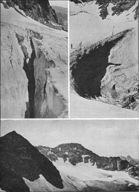
PLATE VI. Upper left: Crevasse in Arapaho
Glacier. Upper right: The Pit, Arapaho Glacier. Lower: The Arapahos and the Glacier. Photographs by Clark Blickensderfer. |

|
|
PLATE VII. Upper left: Taylor Glacier. Photograph by G. H. Harvey, jr. Upper right: Andrews Glacier. Photograph by Geo. C. Barnard. Lower: Part of Sprague Glacier. Photograph by W. T. Lee. |
A camera or kodak is a desirable addition. If there are several persons in the party, the weight of the various packs may be adjusted so that the owner of the camera is not penalized. A No. 3-A kodak weighs slightly over 3 pounds.
A whistle may be useful for communicating with others in the party, and a code should be agreed upon in advance.
A drinking cup is often useful. An ordinary tin cup, hung on one's belt, it better than the various folding or collapsible cups.
A canteen is sometimes desirable, depending upon the locality and season of the year. A canteen holding nearly a quart, weighs, when filled, about 3 pounds.
A piece of candle should always be carried, as the trip may unintentionally be prolonged until after dark. One can always improvise a wind-shield and perhaps a reflector. A small pail or can, if available, is excellent for this purpose.
A barometer is rarely needed when one has an accurate map of the region. However, if a barometer is available, it will add to the interest of a trip by furnishing information as to the rate of progress and enables one to study the zones of plant and animal life with more accuracy.
A weight of 20 pounds or more is a decided hindrance on a climb and may become quite uncomfortable, if the pack is not suitable. On short, one-day trips, one can often go without carrying anything, but on trips to the high peaks, one should be more completely equipped, to provide for unexpected contingencies.
If the trip includes camping out over night, or if it extends over several days, then more equipment must be taken and bedding, cooking utensils and provisions will be needed.
Night clothing can be dispensed with, since preparation for the night usually consists of putting on all the dry clothing available, and taking off only boots and hat.
A hot-water bottle is an item not frequently considered, but for warming the sleeping bag on a cold night it is much more convenient than hot stones. An attachment consisting of a perforated rubber ring, transforms it into a portable shower bath.
CHECK LIST OF CLOTHING AND EQUIPMENT.
The clothing and equipment that should be taken will vary greatly with the character of the trip. Many articles can and should be taken on a camping trip, when a team is used, that would be left at home, for a pack-horse trip, and the weight of equipment will be still further reduced on a walking trip, and the amount to be taken will, of course, be less on short trips than on long ones. "Go light but right" is a good motto. Take enough and no more. The Latin word for baggage "impedimenta," is very expressive. Excess weight increases delays, inconveniences and fatigue.
The following list is given with the suggestion that before a trip you check it over and make sure that you have not forgotten something that you intended to take. Adapt your outfit to your trip and take only the necessary articles.
Clothing (men's):
Suit of corduroy or other stout, warm material.
Suit of khaki or light-weight material.
A hat that will stand the weather and afford protection from the sun.
Change of shirts, flannel or light-weight material.
Change of underwear.
Change of socks, preferably woolen, two pair.
Mountain boots or stout shoes.
Pair of light shoes for change in camp.
Belt.
Slicker, poncho or light-weight rubber coat.
Gloves.
Bedding:
Sleeping bag with one pair (or more) of good, woolen blankets
Waterproof cover around bedding, not less than 4 by 6 feet in size.
Small, light pillow.
Toilet articles:
Soap, towel, brush, comb, toothbrush and paste, razor, nail scissors, toilet paper, talcum powder, lip stick, face cream, adhesive tape, absorbent cotton, bandaging, medicine and first-aid kit, safety pins, hot-water bottle, extra handkerchiefs.
Food and cooking utensils:
Food supplies and other edibles such as nuts, raisins, chocolate and candy.
Utensils, such as knife, fork, spoon, cup, frying pan, stewpan, water bucket.
Miscellaneous articles:
Tent or other protection from the weather.
Candles.
Knapsack.
Weatherproof match box and matches.
Pipe, tobacco or other smoker's supplies.
Pocket knife.
United States Geological Survey or other maps.
Memorandum book, pencil.
Mosquito netting.
Kodak and films.
String, cord, and rope.
Compass.
Field glasses.
Small whetstone.
Nail set (for removing nail points from shoes).
Watch.
Purse.
HEALTH AND HYGIENE.
Climbing is usually beneficial to health. It stimulates the action of heart and lungs. The large quantities of pure air and pure water that are taken into the system during a climb are the best kind of medicine. People with weak hearts, lung trouble, or other ailments, should not undertake the fatiguing trips without securing proper medical advice. There are many lesser heights that offer healthful exercise with only moderate exertion. Short trips are the best possible preparation for longer ones.
One can stand exposure to wind and weather without injury while one is climbing, while perspiration is free, the body warm and heart and lungs active. When resting however, the body should be protected from cold and chill. Upon the return to camp, wet clothes and should be changed or promptly dried out.
Bathing the feet or body in cold water, after a trip often will ward off injurious effects of exposure. Warm bathing should be avoided when there is any chance of a subsequent chill.
If the feet become tired and sore on a trip, bathing in cold water is refreshing. Blisters on the feet may be partly or wholly avoided by wearing two pairs of wool stockings, by putting talcum powder or some other lubricant, in the shoes, or by protecting the toes with strips of adhesive tape. Blisters or sores that have formed may be protected from further friction by adhesive tape. A roll of this tape should always be carried; it has many uses and may be employed to repair torn clothes as well as bodily damages.
Medical assistance is obtainable only in the larger communities, and a party going into unfrequented regions should take along a small first-aid kit and the usual simple remedies. If one member of the party has some medical knowledge, or a familiarity with first-aid principles, it will be a protection to the others.
Climbing increases the rate and depth of breathing, and the rate and violence of the heart action. This should not be carried to an extreme, as a strain or injury might result. Do not spurt. Take such a rate that the heart action, though increased, will be kept at a nearly constant rate. This gives "second wind." A slow rate of progress, with no halts, results in better heart action than the "rush and stop, rush and stop" method. If a person can not maintain a slow gait without frequent rests he should go no further, as it is probable that, even though he might reach the summit, the return trip would be too fatiguing.
Avoid drinking an excessive amount of the ice-cold mountain water at any one time. It absorbs internal heat, produces chills, and is injurious when taken in too large quantities. It is, of course, necessary and desirable to drink abundantly, but extremely cold water should be taken at intervals and in small quantities.
The water of streams should be avoided if it is known that settlements or camps are located higher up on the streams. Drinking water is fortunately not much of a problem in the mountains, as one can usually camp beside some small spring or tributary to the main stream, and thus avoid using the river water. In the higher regions, and above timberline, the water is clear, soft, and absolutely pure. A good water supply is one of the delights of an outing, and all intelligent campers take care to preserve the purity of the stream and the neatness of the camp site.
Alcoholic beverages stimulate heart action and should never be taken during a climb. After a trip, a warm drink is usually preferable to an alcoholic drink.
NOTES ON FOOD.
For a one-day trip a light lunch is better than a heavy one. Take all you care to eat for lunch, but don't carry an unnecessary lot of food up the peak and perhaps back again.
Prolonged physical exertion can only be sustained by a well-nourished body. One should eat before getting very tired, and it is well to follow one's inclination, eating part of the lunch on the way up, if one gets hungry. Digestion does not go well with exertion and it is advisable to eat lunch at the top of the peak or at intervals on the way up. Avoid eating a heavy meal immediately before starting on the steep part of the climb.
Individual preference as to food varies widely. Two or three sandwiches, some cookies, a few nuts, raisins, and a cake of chocolate may be suggested as making a compact lunch and one that can easily be obtained.
Chocolate that does not soften when warm is preferable. Milk chocolate is not good in this respect.
A limited amount of candy is a good addition to the menu.
Packages of small seedless raisins can be obtained that are not sticky. In selecting nuts, salted ones should be avoided, as they produce thirst.
A mixture of nuts, raisins, and "jelly beans" has been found to be excellent for eating between meals. Oranges and apples are good, but if there is plenty of drinking water on the trip, they are unnecessarily heavy, considering the small amount of nourishment that they contain.
The food selected for a trip will depend upon individual preference, the length of the trip, the number of people, and also on the distance to the camp and method of transportation.
Hot meals, or at least hot drinks, are desirable for breakfast and supper. The supply of firewood is always abundant below timberline. Coffee, tea, and chocolate are good breakfast drinks. Tea may be tied in small bags of convenient size and dipped into the individual cup. As hot water is usually available at camp, this makes a drink that can be prepared quickly and in any suitable quantity. "Instantaneous" chocolate is well adapted to camp use; one cupful or many may be quickly made. People frequently have difficulty in sleeping in camp, perhaps because of the high altitude, a hard bed, an insufficient supply of warm bedding, or the unfamiliar surroundings. It is therefore often better to have chocolate for supper rather than tea or coffee.
Canned soups are very useful. After a long, hard trip, when one is both cold and tired, a liberal supply of hot soup is better than a heavy meal.
Dried fruits are good for camp use, as they are lighter and less expensive than canned fruits, but of course they require more time for preparation.
VARIOUS SUGGESTIONS.
SELECTION OF ROUTE
One can usually choose between a valley route and a ridge route. The valley route follows water, and frequently passes interesting waterfalls or lakes, and makes the greater part of the trip at a comparatively low altitude. The trails often follow valley routes and pass near to cabins and shelters. On the other hand, the ridge routes frequently make better going, as they are apt to have less dense undergrowth, less fallen timber, more of the distance is above timber line and they afford better views of the surrounding country. As ridges are dry, a canteen should usually be carried. Ridge routes are apt to have more ups and downs, but the valley route leaves the steepest climb until the last. Both routes have their advantages and local conditions will usually govern the selection of the best route. A circle trip, going and returning over different routes, adds to the interest of excursion.
LOOSE ROCK.
The proverb that "A rolling stone gathers no moss" is sometimes a useful one to remember in mountain climbing. When on a steep slope with much slide rock, the larger pieces of rock, and particularly those with lichens on them, will usually be found the most stable. On the descent, however, more rapid progress can often be made by selecting slides consisting of small rock or gravel, as this material will easily give way under foot and make the descent easy and rapid.
When in doubt of the stability of a rock, it is best to step well on the upper, or hill side, of the rock, as it is then less apt to over turn, and even if it does move, a fall is not so likely to result.
On steep slopes, care should be taken to avoid the starting of loose rock. The party should spread out so that no one is in danger from falling rocks, or if this can not be done, they should go in single file, one close behind the other, so that a rock, if started, may be quickly stopped.
FALLEN TIMBER.
One will frequently find that there is less fallen timber in live forest than in areas that have been swept by forest fire, even though the latter may appear to be more open and seem to present an easier route when seen from a distance.
LOST BEARINGS.
If one should become thoroughly lost, the best plan is to go down hill to a water course and then follow it down until some habitation is reached. This will prevent wandering in circles and one can go farther down hill than in any other direction. Dwellings are on streams, not ridges, and there are ranches near the headwaters of most streams.
RULES FOR A PARTY.
Do not take trips into the mountains alone. A minor injury, such as a sprained ankle or a twisted knee, would be a serious accident to anyone alone in the unfrequented mountains.
The size of the party will, of course, depend upon circumstances. A small party travels faster than a large one, for with a large party delays are more frequent and the speed of the party is limited to that of its slowest member. However, with a large party one or two members may be willing to make all the necessary plans and arrangements, thus saving the others time and trouble. The expense per person is frequently less with a large party than with a small one. The sociability of a congenial party is delightful, especially around the camp fire in the evening.
A member of a party who is unable to proceed on a trip, either because of accident or fatigue, should never be left alone, but should be put in the care of some competent member of the party. If it is necessary to send for help, two or more persons should go.
When a party separates, each group should have its definite leader. These leaders should definitely agree upon a course of action and proceed to carry out the agreement. Contingencies which may arise should be considered in advance, and, when separating, each section of the party should have a clear and definite idea of what to expect from the other members of the party. If they are to meet at any later time, the point of meeting should be a definite place and clearly understood. It is well to agree upon the maximum length of time that one party will wait for the other, and also the subsequent action to be taken in case they do not meet.
When possible, a party should keep together. A leader should be appointed and should assume charge of the party. Others may suggest, but his decision should be final. If any member leaves the party he should get the consent of the leader, and relieve the party of any further responsibility on his account.
If the route to be taken is uncertain, let the leader decide on the course to be taken. Remember that if the party separates, to follow their individual inclinations, the entire party can not resume the trip until the last member has arrived. It is better for the entire party to take the same route, even though it may not be the best one.
For a long or hard trip a small party of equally capable climbers should be selected. A party of four is a good size, as no one need be left alone in case it is necessary for the party to separate.
It is well for the beginner to take the first few trips with some one of more experience. He may thus learn much in a short time that would otherwise have to be acquired by unfortunate mistakes.
There are no trails on most of the mountains, and the selection of the best route is aided by experience. Experience creates ability.
DISTANCE, ELEVATION AND TIME.
Every climber finds it desirable to be able to estimate, in advance, the time required to take a certain trip, and anyone who has reached camp long after dark knows that it is easy to underestimate the time that a trip will consume. To fit the wide variety of conditions and individual needs, each climber should work out his own schedule, but the following is suggested as a trial formula:
Scale the distance to be walked in the round trip, in miles, as shown by the map, and add approximately one-third to give the distance actually to be walked. Determine the number of feet of elevation to be climbed. Add to the distance, as determined above, 2 miles for each 1,000 feet of climb, and the total will be the apparent length of the trip, or its equivalent in miles, compared to a trip on level ground. Divide this total number of miles by two, and the result will be approximately the number of hours required for the trip.
For example, the length of a trip as scaled from the map is 10 miles; the actual distance to be walked will be about 13 miles; the map shows 4,000 feet of climb, which is equivalent to an additional distance of 8 miles. The trip will be about as fatiguing as a 21-mile walk, and will take about 10-1/2 hours. The time given by this formula is usually sufficient to include all stops, such as lunch, views, rests, etc., but some may find that the time of such stops must be added. Each climber may adapt the formula to his own gait by using a divisor either greater or less than two.
The time required for a trip will of course be affected by the number of persons in the party, the character of the ground, the presence or absence of trails, weather conditions, such as snow, rain, or wind, and also by the length of the trip, since the rate of travel decreases with fatigue.
The length of the route as shown by the map is the minimum possible distance along that route and the distance actually traveled is always somewhat greater, due to minor irregularities of the trail or route; hence to get the actual distance walked, an addition must be made to the scaled distance. The addition of one-third, assumed above, is conservative for most mountainous country.
Do not hurry. Take a gait that can be maintained without stopping. "Who goes slowly goes well; who goes well goes far." Most climbers are satisfied with an average rate of ascent of 1,000 feet of elevation per hour.
Start early. "An hour in the morning is worth two in the afternoon." Plan to end the trip before dusk.
A moderate day's trip may be considered as one that takes seven or eight hours, and includes a climb of about 3,000 feet, with perhaps 8 or 9 miles of distance traveled. Such a trip is equivalent to about a 15-mile walk over level country. Most persons, even if not in training, can take a trip of this sort without difficulty. If the climb of a peak is broken by camping at timber line, then one can reach the top of almost any peak without making any day's trip longer than this.
If the length of a trip is increased to 12 hours, and includes 5,000 feet to climb and a tramp of 12 or 15 miles, it may be considered a hard day's trip, and equivalent to a trip of about 25 miles across level country.
If the length of the trip is increased to 16 or 18 hours, and includes 7,000 or 8,000 feet of climb, in addition to a journey of 18 or 20 miles, it will prove in most cases to be an exhausting trip, approaching the limit of physical exertion. The return from such a trip usually involves walking long after one is tired out. It is equivalent to about a 35-mile trip across ordinary country.
A trip of moderate length is more enjoyable than one that brings fatigue long before the end of the trip. When in training one can climb three, four, or even five thousand feet a day, day after day—and enjoy it.
|
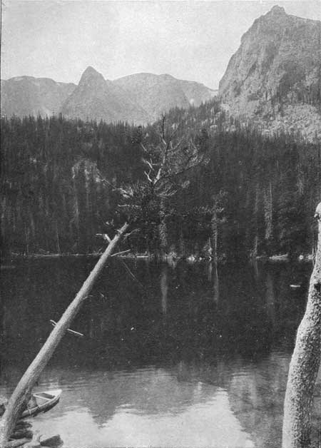
| PLATE VIII. FERN LAKE. Photograph by National Park Service. |
|
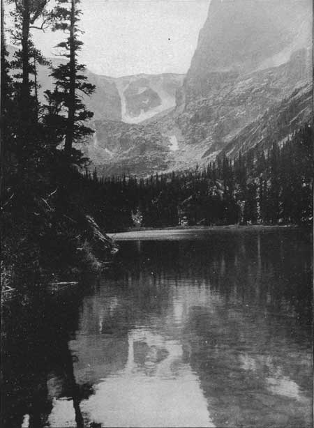
| PLATE IX. ODESSA LAKE. Photograph by National Park Service. |
USE OF THE WORD "PARK."
The word "park" as used in this region has several meanings and is the source of more or less confusion to the visitor. In mountainous regions of the Western States it is customary to refer thus to a comparatively level and open tract of land. North Park, Middle Park, Moraine Park and others have become official titles in Colorado. These parks are usually grass-covered areas either treeless or only sparsely timbered.
The name Estes Park originally meant only the flat lowlands in the valley of the Thompson River and tributary streams, but has popularly, not officially, been applied to a wide area. The application of the same name to the town does not simplify matters, though the latter is usually referred to as Estes Park village.
The boundaries of the national park exclude, as far as practicable, all land that was under private ownership at the time of the passage of the bill creating the park. For this reason, most of Estes Park village, Grand Lake and other areas of private ownership are not included within the boundaries of the national park. The Rocky Mountain National Park includes most of the area formerly referred to by the more inclusive term Estes Park and for this reason the railroads have tried to secure the maximum amount of publicity by the use of some designation including both names, such as "Rocky Mountain National—Estes Park." Eventually the name Estes Park will probably be used chiefly when referring to the village.
MOUNTAIN REGISTER ON LONGS PEAK AND OTHER
MOUNTAINS.
The Colorado Mountain Club placed one of its standard mountain register books, contained in a weatherproof bronze cylinder, upon the summit of Longs Peak, on July 17, 1915. The book was found to be nearly filled on July 23, 1916, and was then replaced by a new book, which in turn was replaced on October 1, 1916. Although exposed to summer and winter weather, the cylinder and register books remained in good condition. The two books contained a total of 883 names. The following tabulation shows the number of entries in the two books, by months:
| Month. | 1915 | 1916 |
| June | ... | 22 |
| July | 132 | 166 |
| August | 206 | 347 |
| September | 22 | 84 |
| October | ... | 24 |
| Total | 260 | 623 |
1July 17 to 31. 2Oct. 1 only. | ||
Late snows in 1915 made the peak inaccessible during June and part of July of that year, and the total number of persons who climbed the peak during 1915 is estimated at 280. This number was more than doubled the following year, and it is believed that more persons climbed the peak during 1916 than in any previous year.
August is the favorite month, with July in second place, a decreasing number of visitors in September and only occasional trips during June and October. The peak is rarely climbed during other months of the year, as it is usually considered difficult and dangerous, if not inaccessible, during the winter.
Nearly one-fourth of the climbers were women. More than half of the people reaching the top of the peak are visitors residing outside of Colorado.
Thirty-five States and Territories and three foreign countries were represented in the list of persons reaching the summit of the peak during the years 1915 and 1916.
The Colorado Mountain Club has placed similar registers on Hagues Peak, Ypsilon Mountain, Hallett Peak, Mount Alice, Mahana Peak, Mount Copeland, Navajo Peak, North and South Arapaho Peaks, Mount Audubon, Paiute Peak, and others.
WEATHER AND CLIMATOLOGY.
SEASON.
July, August, and September are the best months for trips to the high peaks. In June, the winter's snow has usually not left the peaks, and late snows of considerable depth may fall. In October, one-day climbs can often be taken, but there is liability of cold weather and a heavy snowfall. Throughout the winter the lover of outdoor life usually delights in snowshoe and ski trips at lower elevations, and the peaks are practically unvisited, though there are times during an open winter when ascents can be made. Winter storms are serious and may easily become dangerous, and one should not plan winter climbs to high peaks without a full knowledge of the conditions. Even the three summer months there are frequently times when the high peaks are inaccessible.
LIGHTNING.
The mountain storms are frequently accompanied by lightning. If the storm is heavy and the flashes are close, the lightning should be treated with the respect and deference that are usually accorded it. A projecting rock affords the most secure shelter possible. Next to that would be a close thicket of low trees. Avoid the shelter of a tall, conspicuous tree, as it might act as a lightning rod. For the same reason, one should avoid remaining on the top of a peak or on an open, bare area above timberline. The brass cylinders of the mountain registers have been struck by lightning and the chain melted, without injuring the contents. Leave them alone if there is lightning in the air. One is more secure lying on the ground than standing up.
STATIC ELECTRICITY.
One occasionally encounters a so-called static storm. In this phenomenon there are no lightning flashes, but the presence of electricity is manifested by snapping sounds in the air, tiny blue flashes between the rocks, crackling in one's hair, which involuntarily stands on end, and if one's finger is pointed upward small flashes may emanate from it. This static electricity is not dangerous unless an approaching storm indicates that genuine lightning is to follow. The usual procedure is then to "stand not upon the order of your going, but go at once."
AFTERNOON SHOWERS.
The weather in the mountains is controlled by a few natural physical laws which are easily understood and when once grasped will add so much interest to trips in the mountains that a little study of climatic laws is well repaid. Afternoon showers are of such frequent occurrence in the mountains, and one has such a good opportunity to observe the entire life history of a storm, that the following outline may be of interest.
During the day the sun warms the ground which in turn warms the air adjacent to it. Warm air is lighter than cold air, so a rising current is formed. For this reason the wind usually blows up the valley during the day, but reverses its direction at night when the radiation of heat from the ground has stopped and the cold air, no longer driven upward, flows down into the valleys.
The warm air rising during the day reaches higher altitudes where the atmospheric pressure is less. The air expands and expansion is a cooling process. As it cools, its capacity for holding moisture is diminished. First a light cloud appears, then heavier clouds, and soon the downpour begins. It is usually short-lived, however. As the sun is hidden and the ground cooled, the direction of the wind is reversed, the moisture is then carried downward, is absorbed by the warmer air, the sky clears and the storm is over, though a mist may fill the valley.
The precipitation in the mountains is more than it is on the plains, because these rain-producing conditions occur so frequently. Similar phenomena explain the plume of cloud that sometimes clings to a mountain peak, though the wind is blowing and other clouds are sailing by overhead.
If the early morning weather is not favorable to your trip, do not start, as it is apt to get worse rather than better.
SUMMER SNOWSTORMS
During the summer the rainstorm of the valley is often a snowstorm on top of the peaks. The snow is usually not in flakes but the particles are round and sleetlike and sting when driven by a high wind. These summer snows are usually brief and do not accumulate on the ground to any considerable depth; often hardly enough falls to make the ground white. The snow also disappears promptly.
DENSITY OF THE ATMOSPHERE.
The density of the atmosphere decreases with elevation. It decreases in density about one-half for every 3 miles increase in elevation, so that at 14,000 feet elevation the atmosphere is not much more than half as dense as at sea level. The warmth of the atmosphere decreases with elevation.
TIMBERLINE.
Timberline in Colorado varies from about 10,500 feet to 12,000 feet, and is usually found at an elevation of 11,000 to 11,500 feet. "Tree line" would be a more accurate term, since useful timber ceases to grow a few hundred feet below the last trees, which are usually gnarled and stunted. Timberline is governed by climatic conditions and not by the rarity of the atmosphere. It may differ by several hundred feet in elevation in different locations. Thus, on the north and south slopes of the same mountain, timberline may vary considerably. Similarly, it varies in different parts of the country and in general decreases in elevation, as latitude increases, toward the pole.
ZONES OF ALTITUDE.
In a climb to higher altitudes one passes through successive zones of plant and animal life. These zones are determined by the climatic conditions resulting from altitude. The plant life in the zones corresponds quite closely with the plant life of more northern regions. The latitude of the national park is between 40° and 41° north at timberline. The vegetation at timberline corresponds with the plant life that will be found at sea level at a latitude of about 65°. In a trip to the summit of a 14,000-foot peak one passes through the same climatic zones that would be encountered in a trip to the polar regions at about 75° of latitude.
TEMPERATURE AND PRECIPITATION AT LONGS PEAK
INN.
(Elevation about 9,000 feet.)
Weather observations have been regularly taken at Longs Peak Inn since the year 1892.
TEMPERATURE.
Maximum and minimum self-registering thermometers are used, and record the warmest and coldest temperatures of the day. The average of these two readings is called the mean temperature for the day, while the difference between them is the daily range. The following figures, in degrees Fahrenheit, represent a summary of these records for a period of 20 years.
| Month. | Average mean temperature. | Average of the daily maximum temperatures. | Average of the daily minimum temperatures. | Maximum recorded temperature. | Minimum recorded temperature. |
| January | 23.9 | 35.1 | 12.7 | 56 | -21 |
| February | 22.0 | 33.2 | 10.8 | 60 | -31 |
| March | 27.1 | 38.4 | 15.8 | 70 | -23 |
| April | 33.5 | 45.0 | 22.0 | 69 | -9 |
| May | 41.6 | 54.1 | 29.1 | 79 | 3 |
| June | 50.6 | 65.0 | 36.1 | 85 | 19 |
| July | 54.5 | 69.4 | 39.6 | 82 | 26 |
| August | 54.9 | 69.7 | 40.1 | 83 | 22 |
| September | 48.9 | 63.8 | 34.0 | 82 | 7 |
| October | 39.2 | 52.5 | 26.0 | 76 | -10 |
| November | 31.3 | 43.4 | 19.0 | 72 | -17 |
| December | 24.6 | 36.0 | 13.0 | 62 | -27 |
| Year | 37.7 | 50.5 | 24.8 | 85 | -31 |
The above data shows that July and August are the warmest months. The maximum recorded temperature is 85°, though the average temperature in the middle of the day in midsummer is less than 70°. There is no month of the year in which freezing weather has not been known.
PRECIPITATION.
The average monthly precipitation in inches (the snowfall being melted to obtain the equivalent in rainfall) is as follows:
| Inches of precipitation. | |
| January | 0.75 |
| February | 1.06 |
| March | 1.98 |
| April | 2.61 |
| May | 2.80 |
| June | 1.49 |
| July | 2.84 |
| August | 2.14 |
| September | 1.36 |
| October | 1.56 |
| November | .88 |
| December | .62 |
| Total for year | 20.14 |
The spring and summer months have more precipitation than the winter months, July and August being the wettest of the summer months. June and September have only about half the rainfall of July and August. The annual precipitation recorded during the 20-year period has varied from a minimum of 13.5 inches to a maximum of 28.71 inches per year.
The above figures are taken from Bulletin 182 of the Colorado Agricultural College, entitled Colorado Climatology, to which the reader is referred for additional information.
EVERGREENS OF NORTHERN COLORADO.
By
ELLSWORTH BETHEL.
The forests of Colorado consist chiefly of cone-bearing trees commonly called evergreens. The following brief keys will enable any one to distinguish the various kinds found in northern Colorado.
Pines (leaves in bundles of two, three, or five needles):
Rock pine—Leaves in two's or three's; scales of cones with prickles; common in the foothills up to 8,000 feet elevation.
Lodgepole pine—Leaves in two's; scales of cones with prickles; cones remaining on the trees for many years; 8,000 to 10,000 feet elevation.
Limber or range pine—Leaves in five's; scales of cones thick and with out prickles; most common at high elevations.
Bristle-cone pine—Leaves in five's; scales with prickles; at high elevations, rare, not found north of James Peak.
Spruces (leaves short, single; sharp-pointed, four-sided, borne on short stalks):
Engelmann spruce—Branchlets usually minutely pubescent; cones short, reddish brown; dense, forests; from 8,000 feet elevation to timber line.
Colorado blue spruce (the State tree)—Branchlets smooth and leaves often silvery; cones long, light brown; along streams up to 8,000 feet elevation.
Alpine fir—Leaves flat, blunt-pointed; cones upright and falling to pieces at maturity; forests above 8,000 feet elevation.
Douglas fir (not a true fir)—Leaves soft, short, flat, and blunt; cones with exserted three-pointed bracts; common up to 8,000 feet elevation.
Junipers (leaves either scales, or awl-shaped needles; fruit berry-like):
Rocky Mountain cedar or juniper—A small tree scattered throughout the mountains.
Trailing juniper—A prostrate shrub; from the foothills to 12,000 feet elevation.
NOTES.—(a) At timberline are found dwarfed specimens of Engelmann spruce and alpine fir, limber, lodgepole, and bristle-cone pine are often found with these.
(b) The altitudinal ranges given above are only approximate. Occasional trees of each species will be found above and below the elevations here given.
SIX CHARACTERISTIC MOUNTAIN BIRDS.
By
ROBERT B. ROCKWELL.
AMERICAN DIPPER OR WATER OUZEL.
Habitat: Along courses of mountain torrents, 5,000 to 11,500 feet elevation.Size: Slightly smaller than a robin.
Color: Uniform dull, slaty gray.
Note: A beautiful liquid, thrushlike note and during nesting season a noisy chattering note.
Peculiarities: Equally at home on shore or in the swiftest water. Builds a beautiful covered nest of moss where the spray keeps it continually moist. Not migratory.
LONG CRESTED JAY (ERRONEOUSLY CALLED "BLUE JAY").
Habitat: Throughout mountainous area from plains to 10,000 feet elevation. Most abundant between 7,000 and 9,000 feet elevation. Sometimes winters on plains at base of foothills.Size: Slightly larger than a robin.
Color: Wings and tail brilliant, deep blue, head black, breast dull blue chin streaked with white.
Note: A wide diversity of call notes impossible to describe. The harsh loud single note is most common, but many others identify the bird.
Peculiarities: The tall conspicuous topknot and brilliant coloring render it easy to identify.
ROCKY MOUNTAIN JAY OR CAMP ROBBER.
Habitat: Heavy evergreen forests, 8,000 feet elevation to timberline during summer. Sometimes somewhat lower during severe winters.Size: Slightly larger than a robin.
Color: Light slaty gray with white-tipped wing and tail feathers, crown pure white, breast with slight brownish tinge.
Note: A rather weird, harsh single note, or a low-pitched garrulous chatter, quite conversational in tone.
Peculiarities: Tame, unsuspicious, wise to a degree and the craftiest thief of camp provender in the bird world.
AMERICAN PIPIT OR TITLARK.
Habitat: In summer, mountains from 10,000 to 14,000 feet elevation. In winter, south to Mexico and Guatemala.Size: About that of a tame canary.
Color: Light grayish olive above, pale buffy white below, white edging on outer tail feathers. Viewed from a distance, appears uniform light brown.
Note: Males are wonderful songsters during the nesting season. Note during the rest of the year is a weak whistle, but quite characteristic.
Peculiarities: The only truly migratory bird, which nests among boreal weather conditions above timberline.
BROWN-CAPPED LEUCOSTICTE OR ROSY FINCH.
Habitat: In summer, above timberline, 11,000 to 14,000 feet elevation. In winter, just below timberline, unless driven lower by storms.Size: Slightly larger than an English sparrow.
Color: Body cinnamon brown, wings and tail dusky black, edged with pink; wings, tail coverts, flanks, and abodmen washed with pink; head dusky black.
Peculiarities: The highest ranging small bird in America. Not known to exist outside of Colorado. Nest and eggs not found until 1915.
WHITE-TAILED PTARMIGAN (INCORRECTLY CALLED "SNOW QUAIL").
Habitat: In summer, from timberline to tops of highest mountains. In winter, at about timberline, occasionally a little lower.Size: Slightly larger than a bantam hen.
Color: Tawny buff, mottled and barred irregularly with black and white in summer, slowly changing to pure white in winter.
Peculiarities: The most truly boreal of all Colorado birds. The only American bird which changes to white plumage. The only large bird which lives entirely within the Arctic-alpine zone.
Note: Harsh, loud, rattling cackle.
KEY TO COLORADO SQUIRRELS, CHIPMUNKS, AND GOPHERS.
By Robert B. Rockwell.
| Animals with stripes on back. | With stripes only. | Four light stripes on back. Smaller | Little chipmunk. | |
| Two light stripes on back. Larger | Big chipmunk. | |||
| With stripes and spots. | Thirteen stripes on back, six light, seven dark, with white spots. Generally tawny color. | Common striped gopher. | ||
| Animals without stripes on back. | With long bushy tails. "Squirrel-like." Typically in or among trees or rocks. | Ears with long tufts. | Tuft-eared squirrel. | |
| Ears not tufted. | Brown or rufous, whitish below, not mottled. Less than 18 inches long, including tail. Tree squirrel. Friendly and noisy. | Fremont squirrel. | ||
| Sandy colored, mottled. Over 18 inches long, including tail. Large ground-living squirrel. Shy. | Rock squirrel. | |||
| With short tails and not bushy. | "Mole-like." Long front claws. Naked tail. Small eyes and ears. Hair silky. | Pocket gopher. | ||
| "Gophers" in or earth burrows. | Not "mole-like." Large eyes. Coarse fur. Tail hairy. Ears and claws normal. | Picket-pin gopher. | ||
YOUR FRIEND, THE MOUNTAIN.
The dawn is lighting up the eastern sky. The black shadows of the pine forest are taking on detail of trees. The sky is clear. There is a stir at your side. Your companion thrusts his head out of his sleeping bag to see what is going on. Well, the bed isn't any too soft, so let's get up and stretch. Put on your good old boots that have taken so many pleasant and memorable trips with you. Come down to the creek where a splash of water—that was snow a few hours ago—removes any trace of drowsiness and fills you full of energy and ambition. A match, a few dry twigs, then branches, and soon the bacon is sending out its appetizing fragrance and the coffee begins to boil. Did ever a breakfast taste so good? The birds too, know that another new day has come.
Look! The sun has touched the top of the peak and painted it a rosy hue. Watch it creep down the side and light up the lesser peaks all around us. No wonder they used to worship the sun. What a glorious thing it is!
Look! The grand old peak stands there so majestically. He has watched the Sun rise day after day, year after year, for centuries, who will say how many? No wonder he has such a solemn dignity! Follow the slope with your eye, on and on, up and up, to the summit towering several thousand feet above us. The mountain is so great—man is so small. Do you suppose we will ever stand up there on the highest point—it seems so inaccessible, remote and so far above us.
Well, let's start. We will follow this laughing, leaping stream through the forest of fine big spruce, on a soft carpet of moss. How beautiful the flowers are! Hear the squirrel and the other familiar sounds of our wild neighbors. The trees that we are approaching are stunted, and their branches grow only in one direction. Life is a hard battle for them up here at timberline, but they cling to it tenaciously. Here is the last tree. How twisted and gnarled! How many years of slow, slow growth have been required for it to attain its few feet of height?
Now we are entering that other world, the country above timberline. Even the flowers have short stems, as though they are fearful of getting too far from the protecting earth. Look about you; the view is unobstructed. See the valley where we camped last night. Ridge after ridge, peak after peak lies in perspective. Every little white new and more distant peaks show over the nearer ridges. Here and there is a little patch of snow. How refreshing is the clear, cold water! Is this the top ahead of us? No, a little farther beyond there is a higher point.
It is like one's life. The distance to be covered seems so great; progress is so slow; any single advance seems so trifling. Still, with the goal always in view, and every step leading in the right direction, perseverance brings success.
|
|
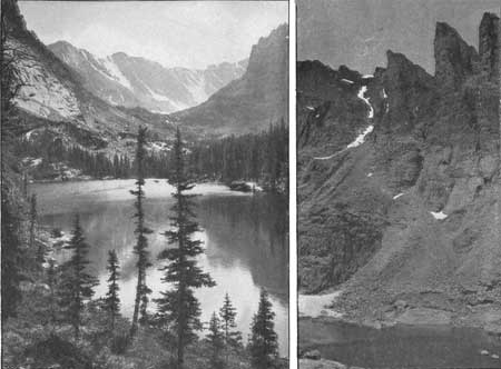
PLATE X. THE LOCH AND ANDREWS GLACIER. Photograph by W. T. Lee. SKY POND AT THE VERY HEAD. Photograph by W. T. Lee. LOCH VALE. |
Surely that must be the top. Well, come on, one pull more. Here we are. Don't exclaim, don't say anything, just look around and below. Miles and miles in every direction. Forest, hills, ridges and peaks; a veritable empire. There in the distance are the plains, with their innumerable little lakes, and away off at the horizon the earth blends with the sky.
How little change the centuries bring to these old mountains! They looked just as they do now when the pioneers came into the country—yes, when Columbus made his first voyage; and as we think back, back over human history, we know that the changes within all of human history must have been slight indeed. Even the trail left by the glaciers still shows clearly, uneffaced by the countless centuries. Surely if one can ever grasp the infinity of time and space, it is here, standing on the peak and looking off to the vanishing horizon.
Take a few more deep breaths; such air! What a feeling of difficulties overcome; success at last! Stretch out your full length on this flat slab of granite. Absorb its strength as did Antaeus, redoubling his power with every touch of Mother Earth.
Here, unwrap that little package. How good the lunch tastes! Now, what time is it? Well, perhaps we should start back. One last look.
Descending is faster than climbing, but slow enough at that. Fatigue makes itself felt. Well, just keep going. Here come the trees again, and the world that people live in. Here is the camp once more and our trip is over.
Tired? How good it feels to stretch out on the soft ground! There will be no sleeplessness tonight but, oh, such a well-earned rest. How the pleasures of this day will remain, long after the weariness is forgotten! And the hardships? Well, they were part of the fun and who will not bear them in happy remembrance?
—R. W. T.
CATHEDRAL OF THE HILLS.
Do you mourn the wrecked cathedrals gone from Antwerp and from Rheims?
Look above you! Nature's temple far surpasses human dreams.
Hush your soul and enter humbly, Climb the velvet-covered stair,
Stand between the massive pillars carved in solid granite there;
Softly tread the mossy carpet spread along the silent nave;
Lo! a glacier for an altar, red with fire the sunset gave.
Here no saints stand carved in marble, folded hands and upturned eyes,
But the figures Nature sculptured point directly to the skies.
While above—the dome of azure with its hangings snowy white,
Touched with rich embroidered colors from the sunset's golden light,
And the priests who serve this temple, guard its halls and galleries steep?
Giant peaks of the Arick'ree their eternal vigils keep.
Was your soul moved in man's temple? You can never be the same
Since to Nature's vast cathedral you in silent worship came.
—Emma R. Barnard.
| <<< Previous | <<< Contents>>> | Next >>> |
romo/toll/part1.htm
Last Updated: 5-Jan-2007