|
Salinas Pueblo Missions
"In the Midst of a Loneliness": The Architectural History of the Salinas Missions Historic Structures Report |

|
CHAPTER 10:
ARCHEOLOGY AT THE SALINAS MISSIONS
EXCAVATIONS AT ABO
In June, 1937, Abundio Peralta sold the pueblo of Abó and the visible ruins of the church and convento to a group of University of New Mexico alumni headed by Pearce Rodey of Albuquerque. The group then donated the site to the University. The University then divided the ownership among itself, the Museum of New Mexico, and the School of American Research.
The three organizations immediately began planning excavation and stabilization work on the mission buildings. The work was of critical importance if the last of the high walls of the church were to be saved, preserving the full height of the side chapel wall to the top of the parapet. The loss of the majority of the side chapel walls during the previous three decades demonstrated that the last remaining section had little time left.
The three organizations had completed planning for the excavations and were awaiting final approval on funding by April, 1938. Joseph Toulouse, a young graduate of the University of New Mexico who had been working as part of a team of excavators on prehistoric sites in Texas, was selected as the field director for the excavations. Reginald Fisher of UNM was to supervise the work.
First Excavations at Abó: June-December, 1938
On June 1, the Soil Conservation Service signed a contract to supply labor to the excavations, and Toulouse moved into housing at the old Civilian Conservation Corps camp near Manzano. He and a crew of about twenty-five men began work at Abó on June 6.
The first priorities were to fence the site to protect it from vandals, and to build a storeroom to protect the tools and equipment left on the site overnight and on weekends. The fencing work proceeded slowly and was not completed until late in the year. Toulouse elected to rebuild several rooms of the ruins of the Marcos Luna house and use it as his toolroom. Work on the reconstruction of the rooms was completed by June 30. Later, in 1939, Toulouse demolished the toolroom and all other traces of the Luna house that he could recognize.
The crew began trenching into the rubble mounds of the convento along the south side and at the southeast corner on June 20. By June 24, the trenches outlined the south wall and southeast corner. The search for the north wall of the convento began. Toulouse began excavating inside the first three rooms at the southeast corner about the same time. [1]
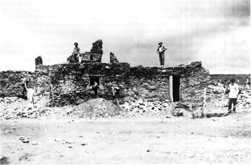 Figure 47. The Marcos Luna house at Abó. It is being converted to a toolshed by workmen under the direction of Joseph Toulouse about June 28 or 29, 1938. The Luna house can be seen in earlier photographs taken at a distance from the church, but only the lower few feet of walls still stood at the time. In 1882 Adolph Bandelier drew its outline on his map of the ruins of the pueblo of Abó, along the east edge of the mounds left by the collapse of the convento. Toulouse raised the walls by about 5 feet and added doors, windows, a roof, and a fireplace. The entire building was removed in late 1939 as part of the final cleanup of the area. Courtesy Museum of New Mexico, # 45415. |
The north, south, and east walls of the convento had been located and the first three rooms cleared by July 6. On the same date, Toulouse began construction on the scaffolding along the west wall of the church for use by the stabilization crew, employing a team of carpenters from the Soil Conservation Service.
The excavation crew excavated the church from July 6 through the end of the season in late December. Stabilization work on the west wall of the building continued during the same period. Toulouse's first priority was to locate the end walls of the church, since both had fallen so completely that only nondescript mounds of rubble marked the general location of these two areas. The north end of the church, Toulouse decided, extended across the property line onto Federico Sisneros's property. Until Sisneros agreed, on July 27, to donate the narrow strip of land to the University, Toulouse concentrated on the south side of the church. Because the access to the convento along the north side was so restricted within the land owned by UNM, work on the convento also concentrated on the south side during this period.
By the last week of July, the excavators were seeing the flagstones of the south terrace, and finding the first charred beams of the fallen choir balcony at the front of the church and the balustrade and roofing of the portería. Toulouse began to see the first indications of the walls that had supported the portal or choir balcony across the front of the church in late July and he began excavations along the walls inside the church. By August 16, the crew had located both sides of the main entrance doorway of the church at the south and seen the first indications of the charred sill beams. [2]
Toulouse's notes for the items, features, and artifacts found in 1938 are difficult to use because the coordinate system of 1938 differed from that used in 1939. The 1939 system is recorded on the plan of the mission published in Toulouse's final report and described in the report. The 1938 system, however, is mentioned only in passing in Toulouse's diary, when he states that he will use forty-foot squares and four-foot units. Fortunately, references to physical locations of items within rooms, and a detailed plan of the locations of a number of charred beams on the south porch at the front of the church and in the portería, allow a reconstruction of the 1938 coordinate system. The places of discovery of many of the artifacts found by Toulouse can be located on his plan to within two feet using the two grid systems. It is difficult to transfer these locations accurately to the most recent HABS plan of the buildings, however, because Toulouse's plan is distorted. A rectilinear grid cannot be drawn on the recent plan that replicates the 1938 and 1939 coordinate systems. Nonetheless, most artifact locations can be reconstructed with little loss of accuracy.
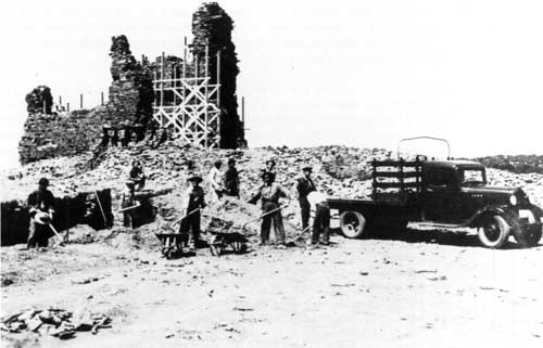 Figure 48. Stabilization and excavation of Abó by Joseph Toulouse, 1938. The photograph was taken in the last week of July or the first week of August. In the foreground, a crew is clearing rubble away from the north wall of the convento in the process of tracing the wall face outside rooms 13, 14, and 15. In the background, the scaffolding for the masons stabilizing the west wall is visible on the inside and outside faces of the wall, but no work has started on the north end around the bell tower. Courtesy Museum of New Mexico, # 6357. |
After Sisneros agreed to donate the property along the north side, the crew began trenching for the apse end of the church. The excavations at the north end soon demonstrated that the surviving wall here was very low, and as of August 17 no clear indications of the rear wall had been found.
The following day excavators began to see the top of the west side-chapel altar as they trenched to trace the west wall north from the bell tower. Toulouse described this as an "adobe structure" at first, indicating that it was made predominantly of adobe brick. [3] Later he revised his description, saying the altar had a rubble stone core with adobe facing. On August 19, work began on rebuilding enough of the west side-chapel wall to form a buttress for the bell-tower.
The crew finished exposing the sill and fallen beams at the front of the church in the last week of August. From here the excavation began to uncover the rest of the south terrace, following it east and west across the front of the church. By September 13, they had located the south wall of the baptistry (room 4) and indications of the "east porch," the portería of the convento.
During the week from September 15 to September 21, 1938, Toulouse uncovered the burned bench lying on the flagstone floor of the portería. This process was especially difficult because part of the roofing and the balustrade across the front of the portería had fallen across the bench as the building burned, and Toulouse had some trouble determining which pieces belonged to which construction. [4]
By September 28, Toulouse had cleared the portería, and was almost certain that the walls on the west side of the church were the baptistry. When he discovered the niche and altar on the north wall of the baptistry the next day, it confirmed the identity of the room.
During October, Toulouse began excavating within the nave northward from the main entrance of the church, and within the convento from the door opening off the portería. On October 13 he found the fireplace at the west end of the south corridor.
The stabilization crew finished work on the bell tower and its associated walls and buttresses on October 26. During the first few days of October the crew had lifted huge beam sections into place high on these walls, filling the spaces left when the originals burned out of the walls. On the last day of October Toulouse removed the scaffolding from the bell tower and began shifting it to the south end of the wall for reconstruction of the south buttress, baptistry, and front wall on the west.
At the end of the first week of November the crew found the first indications of the stairs to the choir loft. They had been tracing the walls of the south and west corridors, and in the process located the entrance to the choir stairwell. By November 14, the choir stairs had been uncovered to their surviving height.
Stabilization on the baptistry area proceeded rapidly. By November 21, the crew was placing the new piñon beams of the lintel for the baptistry doorway. Bad weather was beginning to hamper operations, however, and Toulouse began to plan for closing down for the winter. The last stabilization work for the year was the completion of the baptistry doorway and the walls above it. Perhaps one-third of the interior of the church had been emptied. Along the west wall, the crew had reached the floor from the front entrance almost to the side chapel. In the central and eastern areas of the nave, the fill had been removed to forty feet north of the front wall. Throughout the nave, the crew found large fragments of burned vigas in the rubble.
The crew did no stabilization work on the east wall of the church during 1938, nor did the excavation team find more than traces of the north wall or the altars in the sanctuary. These structures and the sacristy were not defined until the 1939 season.
In the convento, the excavation crew exposed the west half of the south corridor, enough for Toulouse to know that "a number of doorways" opened off of this hall. In the west corridor, work stopped with only the southern third of the hall excavated. In all, no more than perhaps a tenth of the convento had actually been excavated. However, the north, east, and south walls of the convento complex had been defined, so Toulouse knew the limits within which he would be working during the next season. The excavations closed down the 1938 season on December 22.
The Second Season: February-October, 1939
Toulouse returned to Abó on February 15 for the 1939 season, which was funded as a Works Projects Administration undertaking. Detailed records for this year are not available, but general details can be determined from Toulouse's final report and the excavation record and artifact record sheets prepared during the season.
Excavation continued where it had been left off in December. Within the church, clearing of the rubble filling the nave and sanctuary progressed, and the search for the north wall finally succeeded in late May. [5] Stabilization concentrated on the east wall of the nave for the first few months.
During the clearing of the nave and sanctuary, Toulouse stopped excavating when he reached what he considered the floor of the church. Only when he saw recognizable architectural or cultural features in the floor did he go deeper. The stone bases of the pillars supporting the choir loft were defined by cutting into the floor of the church, and several child burials in a single grave pit were investigated in the same way. [6] Toulouse's failure to recognize the foundations of the north wall of the first church across the sanctuary, or to see other burials that more recent archeology suggests are plentiful, confirms that he was careful about following floors.
He followed the same methods in the convento. Again, only when he thought he recognized deeper features did he cut through the final floors of the building. The kiva in the west courtyard and some walls of the earlier patio were traced by deeper excavation, as was the lower floor of room 15, but Toulouse did not see the many other wall foundations only inches below the floors of the rooms and corridors. [7]
Most of the convento rooms were located by trenching and given identifying numbers by the end of February. In the convento, the excavation crew began emptying the rooms along the south corridor and digging a rectangular network of exploratory trenches across the rest of the building. The short hall connecting the east corridor to the east courtyard and the room just north of it were the first rooms to be defined outside of the row of rooms and corridor along the south side of the convento.
Excavators working on clearing the sanctuary and the altars found the doorway to the sacristy. The general plan of the convento quickly became apparent after that. The sacristy and the three rooms east of it were defined, then the kitchen south of room 10, and so on.
After their outlines were determined, each room was cleared of rubble down to the floor level. Room 15 had been cleared down to its upper floor level by February 22. [8] Most of the sacristy (room 12) and the adjacent room 17 had been emptied to floor level by February 28, although some areas of the room were still being emptied in mid-June. [9] The clearing of the storage room (room 11) was nearing completion by March 3, and room 18, the sacristy storeroom, by March 21. Rooms 16 and 22 were still being cleared in late April, while work in room 20 continued to mid-May. The excavators finished most of room 14 in late May and emptied the privy itself (Toulouse's "turkey pen") during the first week of June. The East Court was emptied from March through June. As the excavation crews completed the emptying of each room, stabilization crews began work on repairing and rebuilding the walls.
The greater part of the burned wood came from a limited area. Most of the material was found in the church, sacristy, baptistry, portería, and on the South Terrace. Within the church and sacristy, the sections of burned beam were mixed into clean fill on the floors ranging from six to twelve inches deep. Toulouse considered the fill to have been blown in, but some of it could easily have been the earth from the roof itself, dumped in as the roofing collapsed. Blown fill would then have covered this irregular layer. On the South Terrace, beams were found in the "blown fill" at depths ranging from directly on the flagstone of the terrace to as much as two feet above it. In the remainder of the convento, significant amounts of charred wood were found only in the sacristy storeroom (room 18) and the kitchen storeroom (room 11). A layer of charcoal was found above the lower floor level in room 15. The rest of the convento apparently had very few charred beams. Whenever the fill of a room was mentioned, it usually consisted of a foot or so of blown fill covered by one to several feet of fallen wall debris.
While cleaning out room 17 in late February, Toulouse encountered fragments of intricately carved and painted wood and carved gypsum fragments with mica decorations. These may have been the remains of one of the altar retablos from the church. [10]
During the excavations within the west courtyard, or patio, Toulouse located the kiva and indications of an earlier version of the convento. The excavation crew cut two trenches across the patio, one north to south and the other east to west. These trenches located the sides of the final patio, and its ground surface. Toulouse's profile drawing of the kiva and photographs taken during the work indicate that the kiva was first seen as a depression in the patio surface. According to the excavation records, this was in about mid-March. When the reason for the depression was sought by further trenching, the excavators found the kiva and the east and south walls associated with earlier versions of the patio.
The trenches were continued down into the kiva, leaving sections of the fill at the sides of the structure. By March 22, the trenches had been excavated four feet deep. By March 30, the excavations had reached a depth of six feet and had found the top of the layer of refuse shown in Toulouse's profile drawing.
In the first week of April, Toulouse began to see the structures on the floor of the kiva. The first detail seen was the top of the deflector of the fireplace. By April 24, the crew was excavating the firepit, and the emptying of the ventilator shaft took place in the last few days of April.
During May, Toulouse removed the remaining sections of fill in a more careful manner, attempting to detect any stratigraphic structuring. Apparently two blocks of fill were left. The top several feet of one were removed in the first two weeks of May. In the second half of May the rest of one block and all of the other block were removed at the same time. The final cleaning and stabilization of the structure was carried out throughout June.
Meanwhile, the clearing of the rest of the patio continued. The excavation crew began in the southwest corner during the last week of March, and were digging out the west side by mid-May. At the end of May, they were clearing the southwest corner.
Although in Toulouse's final report he implied that the walls of the earlier patio formed a somewhat raised walkway along the east and south sides of the later patio, the photographs taken during excavation indicate that the later patio floor was at the level of the tops of the earlier foundations. In its final form, the patio was a flat space level with the floor of the surrounding corridor, with no visible trace of the earlier foundations. The kiva apparently continued as a circular structure in the center of the patio about six feet deep.
Most of the majolica found by Toulouse came from the kiva in the west court and from around "annex 2," interpreted here as an entranceway or porch into the guardian's quarters. [11] Additionally, virtually all the Chinese porcelain came from the kiva. This is curious, because the refuse in the kiva was dumped in a single episode, with fragments of the same vessels mixed throughout the material. It is likely that the refuse was not from "the nearby kitchen," as Toulouse says, but was brought from a midden and dumped into the kiva as part of its backfilling, after the structure had been unroofed for a period of time long enough to build up an irregular layer of blown sand to three feet deep. The refuse would have built up somewhere around the convento between the construction of the building beginning in 1622 and the filling of the kiva in about 1650 as part of the first renovation of the west courtyard. The material from the kiva must therefore date from between 1622 and about 1650. [12]
At the same time that the convento rooms were being excavated, Toulouse began clearing around the outside of the church and convento to the colonial ground level and investigating the structures around the church complex. In early April the crews were working outside the west transept and they probably traced the out lines of the Spanish buildings west of the church in April and May. Toulouse determined that the plaza areas to the west of the church had been used on occasion as corrals, based on the layers of animal dung found both here and in the east courtyard of the convento. [13]
The crews began clearing the area just north of the church in early June, and continued on across the walled enclosure to the north. [14] Room 29 at the northwest corner of the walled area was excavated in late June. Toulouse called this area the "mission gardens." [15] During this period he must have also excavated the ruins of an L-shaped building near room 29 within the "garden."
Beginning in late June, the crews cleared along the south and east sides of the convento. The ruins of Marcos Luna's house, converted to a toolshed by Toulouse in 1938, were probably removed about June 22 while the area north of room 1 was being cleared.
Toulouse completed all excavation by the end of June, 1939, except for a few detail excavations, such as the exploration of the lower floor in room 15. [16] Stabilization work continued until October. During this same period, the construction crew probably built the present visitor contact station and the old restrooms west of the church on the west fence line.
Excavations in the Pueblo
Bertha Dutton, 1944
In 1944, Bertha Dutton conducted a series of test excavations in some of the pueblo mounds of Abó. Of these, "Test I" sampled part of mound J in the historical pueblo. [17] Dutton's excavations examined three rooms (or two rooms and a porch on the west). The ceramics indicated that the rooms were abandoned in the late 1600s. [18]
Dutton tested three other areas west of the arroyo between the historical pueblo and the older house mounds. These excavations revealed the complexity of the structural history of the pueblo, and found evidence that the first houses may have been constructed as early as the mid-tenth century. [19]
Ray Ghent, 1958
In 1958 the Museum of New Mexico conducted further excavations at Abó. Ray Ghent, an archeologist with the Laboratory of Anthropology, excavated two rooms at the east end of mound I, just west of the baptistry of the church. He began work on May 15, and wrote a brief three-page report on May 22. [20] The two rooms were left open, and eventually capped and stabilized.
Ghent found that both rooms measured eight feet wide and nineteen feet long, with the long axis oriented east-west. The two rooms were adjoining, sharing one wall. [21] In room 1, Ghent found an adobe floor on which were ash and charcoal, including charred corn-cobs; animal bones; some worked stone items; a clay effigy figure of a bull; Indian ceramics; and some "Spanish potsherds," presumably majolica.
Room 2 contained many more items of Spanish manufacture. On its adobe floor, Ghent found four objects of iron: a hatchet, a chisel or wedge, a nail, and an undescribed "implement." Also on the floor was a copper rod six inches long and 1/8 inch in diameter, and a thick layer of ash and charcoal containing animal bones. In the southwest corner of the room, Ghent found a fire pit, but he did not describe it.
Ghent saw what at first he believed to be a stone "pavement" eighteen inches wide along the north wall of room 2. The "pavement" extended from the northwest corner along the wall to about four feet from the east wall of the room. Here it turned a right angle, ran across the room, and disappeared under the south wall. Ghent excavated two pits through the adobe floor of the room to examine this "pavement." He found a second floor fifty-eight inches below the first. The "pavement" along the north wall of room 2 turned out to be the top of the wall of another room on the remains of which room 2 had been built. Ghent did not describe the fill beneath the floor of room 2. The north wall of the buried room was distinctly odd: the first forty inches above the floor were made of "pressed adobe brick," as Ghent calls them. Above this, the remaining eighteen inches were of stone.
In the northwest quadrant of room 2, Ghent found a burial. He identified it as male, probably Indian, 35 to 40 years old at the time of death. The burial was about two feet deep beneath the floor of room 2, lying on its back, knees "doubled up," oriented with the head towards the west. On the chest of the burial were "parts of 2 pots." The cranium showed distinct flattening from a cradleboard, and rested on the decayed remains of a "board."
Stewart Baldwin, 1982
Stewart Baldwin excavated three rooms in mound J of the historic pueblo in 1982. During the excavations, Baldwin was under the impression that the three rooms had burned out at some point during the historical period and were then reoccupied and rebuilt. Examination of Baldwin's results has prompted Park Service archeologists to propose an alternate explanation. They suggest that the three rooms were originally two stories high. The collapsed roofing found by Baldwin was not the result of two occupations, but of two floors falling into the room fill. [22]
Park Service Excavations
The Drainage Project of 1984
No known archeological work was conducted in the church and convento of Abó during the forty-five year period between October, 1939, and the summer of 1984. For several years prior to 1984 the Park Service had been noticing drainage problems within the stabilized ruins of the church and convento, causing deterioration of the stabilized walls. In early 1984 the Park Service developed a plan for the installation of a drainage system in the mission that would relieve most of the problems.
The plan called for a two-sided approach to the problem. Where appropriate, Salinas National Monument would add fill within the church and portions of the convento to create sloping surfaces eliminating low areas and encouraging drainage. Where the walls themselves formed catch basins, perforated polyvinyl pipe would be installed in trenches, in association with impermeable plastic sheet below sterile fill. The sheet would catch surface water and lead it down to the pipes, which would channel the water to dry-barrel sumps.
The system would require trenching in the convento for the installation of the pipes. Because Toulouse had encountered some below-floor walls in the patio, the Park Service anticipated that further foundations could be present below other parts of the building, and assigned an archeologist to monitor the excavation of the trenches and record any significant findings with photographs, notes, and drawings. [23]
Jim Trott began excavations in the south row of rooms in late May, 1984. The pressure of other work pulled him away by the end of June, and archeologist Susan Kreger took over the work. She excavated and recorded the remaining trenches from late June through mid-August. During the excavations, Trott and Kreger found a number of wall foundations beneath the present floors of the convento. No plaster was found on any of the wall surfaces, nor were floors seen in association with the walls. Trott and Kreger were convinced that the walls were those of an earlier version of the convento, but were unable to find conclusive evidence of this hypothesis within the limits of the excavations. [24]
Park Service Excavations in 1987
Rediscovery of the First Church and Convento of Abó
In 1986, when the detailed, large-scale HABS drawings of Abó became available, the author conducted an intensive analysis of the Trott-Kreger excavations and the Toulouse excavations. He plotted all of the known sub-floor foundations onto the plan of Abó as precisely as possible, and noted any other oddities or peculiar features found during the two excavations.
This analysis supported the idea that an earlier convento had stood on the site of the present convento of Abó. Its floor surface had apparently been at the same height as the present floor. The author was able to work out a tentative plan of the earlier building and found hints that some of the walls of the first convento may have been reused in the later building. A careful examination of the surviving colonial walls confirmed this supposition. When the conjectural plan of the first convento was drawn out, it became obvious that it was too small and too simple to have been built in association with the present church. An inspection of the standing church walls suggested that the present church may have been constructed by rebuilding a smaller, simpler church, reusing some portions of the earlier building in the same way that some parts of the first convento had been reused.
 Figure 49. The first church of San Gregorio de Abó. This photograph, taken during excavations in March, 1987, shows the walls outlining the apse of the church. |
The results of the analysis of the plan of the church and convento strongly indicated the presence of an earlier church and convento beneath the standing ruins of Abó. Proof that such a church and convento had existed and had been altered to create the present structures would have a strong impact on the Historic Structure Report for Abó. The author decided that before the final description of the construction of Abó could be written for this report, archeology had to be conducted to prove or disprove the theory that the present buildings were remodeled versions of earlier structures.
In October, 1986, the author prepared a research proposal for archeological investigations at Abó. It described the evidence and reasoning behind the hypothesis that an earlier church and convento had existed and the archeological steps necessary to prove or disprove the hypothesis. The staff of the Cultural Research Center of the Southwest Regional Office of the National Park Service, responsible for approving such a proposal, reviewed the document and approved it.
Because of early snows, the excavations had to be delayed until the spring of 1987. Fieldwork began on March 21 and continued for ten days, ending on March 31. The excavations were designed to prove the existence of an earlier convento and show its general plan by digging at selected places where walls should intersect if the hypothetical plan worked out during the analysis was correct. At the same time, a series of units within the church would test the idea that the building was a reconstructed version of a smaller structure and would determine its plan.
The excavations succeeded in locating the walls of the earlier church and in proving the existence of an earlier convento. In fact, the evidence from the convento excavations showed that the convento had been constructed originally with one plan and then extensively rebuilt twice, modifying various sections of the building. [25]
The evidence showed that Abó had a very complex structural history, much more so than either of the other two missions covered in this HSR. The findings will require considerable changes to the interpretation of the site and will pose a number of problems for maintenance and stabilization. One result of the work is the National Monument's proposal to cap the foundations of the north wall of the first church, raising it to grade so that it will be visible to visitors. This will help the interpreter convey the idea of the change from first to second church much better than sketch plans and narrative alone. Other developments to the interpretation of the building will occur as usable approaches to its complexity are found.
ARCHEOLOGY AT QUARAI
Scientific archeology arrived at the Pueblo of Quarai in August, 1913, with the beginning of the Summer School of American Archeology on the site. This was an archeological field school conducted jointly by the School of American Archeology, the Museum of New Mexico, and the University of New Mexico. On August 21, the first day of the field school, the Museum acquired the site in a ceremony at Quarai. The apparent owners, Senator William M. McCoy and J. P. Dunlavy and John W. Corbett of Mountainair, transferred the title of the forty-acre tract to the Museum of New Mexico. [26]
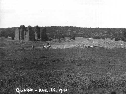 Figure 50. Quarai on August 26, 1913. In the foreground is Mound A, with the School of American Research excavations in progress. Just above the mound is the Lucero House, showing signs of deterioration on the enclosing wall. The house appears to be just behind the mound, but this is an effect produced by Lummis's camera lens. The walls of the convento have all fallen to within a foot or two of the tops of their rubble mounds, and the east wall of the nave has fallen into the church. Courtesy Southwest Museum, # 24837. |
The Field School conducted an initial survey of the pueblo, church and convento, and surrounding area. From August 26 to August 28, Charles F. Lummis rephotographed the area. The students prepared a detailed map of the church and convento complex and a sketch map of the upper Quarai valley. [27]
The Field School accurately measured the church and convento. The sizes they found for the components of the church are within inches of more recent measurements. Outside the east wall of the church, the sacristy (room 4) had recently been excavated, apparently by treasure hunters. Lummis photographed its walls, which descended into the rubble mound covering most of the rest of the convento, and the plan showed the outline of the room with its measurements and the note, "room below level." The walls of the two-story room at the northeast corner of the church (room 6) stood to a height of about ten feet above the rubble.
To the east, the top two or three feet of the walls of the best-preserved rooms along the hall showed above the rubble mound. They appear in the background of several of Lummis's photographs. The Field School plotted the outlines and measurements of rooms 11, 12, 13, and room 10A in the south end of the corridor, as well as about forty-three feet of the west wall of the hallway. In addition, they marked in the north wall of room 15, the east wall of rooms 15 through 18, and the south wall of room 18. [28] They did not recognize any of the rooms of the east courtyard, but plotted the east terrace wall and rooms 48, 49, and 58. They construed the terrace wall and the east wall of the old granary (rooms 47, 50, and 51) to be the outline of two other rooms.
The map of the valley accentuates the Lucero acequia system and the terraces. The acequia was dry by 1913, but the dam and ditch were visible. Lummis photographed the visible remains of the dam, and the map showed both its location and the first several hundred feet of the acequia. The Field School paced out the major components of the terraces. Their rough plan was the first map of the terrace system in the Quarai Valley. [29]
 Figure 51. The area of the sacristy of Quarai in 1913. Lummis stood on top of the stub of the wall of room 6 to take this photograph. Just past the corner of the transept, the hole excavated into the sacristy can be seen. In the middle ground the walls of rooms 11, 12, and 13 have all fallen to heights of about one or two feet on the side toward the camera. On the east side, the walls stand four or five feet above the sloping rubble. Courtesy Southwest Museum, # 24838. |
The Field School worked out a plan of the pueblo mounds. It did not correspond closely to more recent maps because the surveyors made an extremely subjective division of the pueblo into room blocks. The principal mounds can, however, be recognized. The Field School designated the present mound A as mound E on their plan, for example. They indicated the North House as a large unlabelled rectangle north of the church and convento. They apparently considered the Lucero House to be out of the area of the plan.
Probably the most striking detail on the plan is the depiction of a protective wall enclosing the pueblo of Quarai. No other visitors to the site mentioned such a wall, nor did the detailed model of the pueblo made the next year by J. P. Adams show it. It was probably the product of the perceptions of that particular Field School, based on random alignments of rubble. [30]
The Field School returned to Quarai in 1914. Along with the regular field work, J. P. Adams surveyed the site and prepared a topographic map of the mounds and ruins. During the last part of 1914, commissioned by the Museum of New Mexico, Adams built a model of Quarai as it might have looked in the seventeenth century. [31] The Museum displayed the model at the Panama-California Exposition that opened at San Diego, California, in January, 1915. After the closing of the Exposition, the model resided in the Governor's Palace. [32]
Jesse L. Nusbaum, Superintendent of Construction for the School of American Archaeology and Museum of New Mexico, inspected the condition of the Salinas missions in July, 1916. His photographs of Quarai show no significant changes to the structures. In one picture, a section of a wall of the North House can be seen behind the church standing to a height of seven or eight feet. [33]
The Museum of New Mexico lost title to Quarai in 1916. For the next sixteen years the mission property remained in private hands. During this time, the town of Punta de Agua built a new acequia system down the Quarai Valley. The construction took place between 1916 and 1919, and the acequia was in operation by April 4, 1919, when it was surveyed by E. M. Fenton. The new acequia began at a spring about 750 feet up Zapato Creek from the old dam, and followed a different course down the edge of the arroyo. It supplied water to twenty-two tracts and flowed along the south side of the town of Punta. [34]
In 1932, after a long legal battle, the Museum of New Mexico managed to repurchase the land, making it possible to continue with the plans for excavation and stabilization of the ruins. The Museum began large-scale excavations in 1934. Under the general supervision of Edgar L. Hewett, Sam F. Hudelson began work on the church of Concepción de Quarai on June 1. Paul Hudelson became the director of reconstruction and excavation on July 8. Donovan Senter, a student archeologist, was Hudelson's assistant. [35]
On July 9, the workmen began excavations in the area of the sacristy, where they were to build a buttress to support the northeast corner of the transept. They found the crosswall dividing the sacristy into two smaller rooms, and about ten feet below the surface they reached the flagstone floor. [36] The workmen began excavation on the western half of the sacristy and the area of the doorway through the wall into the east transept on July 18. They followed the flagstone floor of the sacristy through the doorway into the church.
The excavators began work on the east wall of the church on July 20. They found that the wall had fallen into the church in a single mass. It covered the nave in a layer about four feet deep, with most of the stones in their original relationships. On July 23, the workmen began clearing the loose rock along the facade, in preparation for removing debris from the interior of the church. They soon revealed the rooms of the baptistry at the southwest corner of the church. The tops of the walls of these rooms were about two feet below the surface of the rubble.
As workers with the Civilian Conservation Corps removed the thick mass of material left by the fallen east nave wall within the church, burned wood began to be found in the older fill beneath. Donovan Senter described the stratigraphy. He found the fill to be ten feet deep where the east wall had fallen, and six feet deep in the transepts and apse. Most of the fill was wind-blown deposits. A half-inch thick layer of white gypsum wall plaster covered the flagstone floor. Above this was a layer of dirt, some of which was probably washed from the interior surfaces of the church walls, the roof, and the choir loft, mixed with blown sand and some rock from the walls. [37]
 Figure 52. Excavations in the church of Quarai, first week of August, 1934. This photograph was probably made by Donovan Senter. The fill has been emptied from the church for about the first thirty feet on the east side, except for a block left in the southeast corner. On the west side the fill remains to within about ten feet of the front wall. Floor level can be seen at the front door, where the lintel has already been installed about one foot too low. The lintel of the west window of the nave has been reinstalled, and the wall rebuilt above it. Courtesy Museum of New Mexico, # 6676. |
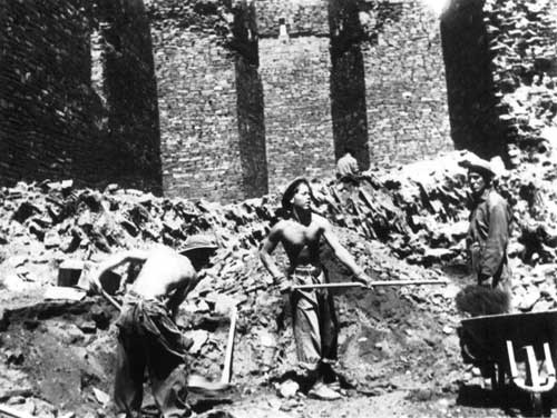 Figure 53. Removing the fill from the nave of Quarai, first week of August, 1934. The fallen east wall of the nave can be seen behind the workmen, with the stones still in approximately their original relationship to each other. The workmen are standing about on the original floor of the church. Courtesy Museum of New Mexico, # 6675. |
A distinct layer of burned material from the roof had fallen onto the dirt layer, covering most of the interior. In the south end of the nave Senter could see a second layer of burned material from the choir loft beneath the roof material. The dirt, scattered rock, and layers of burned material added up to a fill thickness of about three feet.
Above the layer of burned material the excavators found a stratigraphic record of the continuing decay of the building after the roof was lost. In the nave this consisted of another layer of dirt and blown sand, then the fallen east wall, and a final layer of blown sand and some dirt. In the transepts the sequence was the same, without the four-foot-thick layer of fallen nave wall.
Between July 31 and August 15, the CCC cleared the southern forty feet of the sixty-foot nave. Senter found five burials in this southern two-thirds of the nave. Four of these had been interred above the flagstone floor in the clay and scattered stones fallen from the wall, but before the roof burned. [38] The burning beams had scorched several of the skeletons when they fell. The excavators found the fifth burial just inside the entranceway of the church, below the flagstone floor. [39]
The excavations found "a number of vegas [sic] in very fragmentary condition," all charred. One three-foot long piece, apparently from the choir loft, preserved its carved surface. Of these carvings Senter says, "he who cut it must have had some knowledge of geometry." He found it against the east wall of the nave, about six feet from the southeast inner corner of the church, and less than a foot above the flagstone floor in the layer of burned material attributed to the choir loft. A second large beam fragment came from the same layer, against the east wall eleven feet from the southeast corner. [40]
Senter returned to the University of New Mexico in late August, and Albert G. Ely took his place as archeologist. The CCC continued clearing the church with Ely supervising. They found thirty-six burials in the fill above the flagstone floor, most of them in the transept.
Only fragments of the altar bases in the transepts remained. Traces of white plaster still adhered to the surfaces. Ely described the results of Governor Marín del Valle's efforts in the sanctuary: "The high altar had been completely destroyed, and also the greater portion of the three steps which lead from the transept to the apse." The western three feet of the steps remained, with traces of a wooden tread on the "first" step, probably the southernmost. Treasure hunters had hacked a large tunnel, five feet wide and four feet high, through the north wall of the apse. Although never mentioned by Ely or recorded on any plan, the excavations located the platforms in front of the side altars and the stairs to the main altar. These are visible as rectangles of packed earth outlined by the flat slabs of the flagstone floor of the church. The platforms probably had wooden beams forming their edges, but no traces of these can be seen in the photographs. [41]
 Figure 54. The west transept and apse of the church of Quarai in the fall of 1937. In the northeast corner of the transept the west side altar base still stands, and closer the last traces of the main altar stairs remain at the west side of the apse. The socket for the stair bannister on the corner of the apse has been filled. In the foreground at the lower right corner of the picture, the top of the east side altar base is just visible. The surviving flagstone of the transept can be seen, and the rectangular areas of bare dirt in front of each of the altars. High on the west wall of the transept, patches of white wall plaster can be seen. Some of this patch still survives today. High in the apse the horizontal socket of the retablo support beam runs beneath the sockets of the apse roof vigas. Above these, the severe collapse around the sockets of the transept roof beams is visible. This collapse was caused by the burning out of the main viga that ran across the north face of the transept just under the corbels of the transept vigas. It supported the transept vigas over the mouth of the apse. One description of the same area on the east side of the apse stated that about four feet of the thickness of the masonry had fallen away from around the beam sockets. Courtesy Museum of New Mexico, # 87726. |
Albert Ely left Quarai in late April or early May to write his thesis, using the excavations as his topic. CCC excavations continued in his absence, probably under the direction of Reginald G. Fisher, who mapped the church and convento in May. The work located the square kiva in the friary patio. [42] Ele Baker arrived about August, 1935, in time to supervise the removal of the last foot or so of fill and clean the floor features. Baker resumed the excavations of the convento where Ely left off. [43]
In the last of the fill in the square kiva, Baker noticed a large percentage of white "gypsum" plaster. On the floor, he found a "fire pit, altar, and 'sip-o-phe' [sipapu]," [44] but observed no artifacts. [45] However, at some point the excavation recovered most of a large Salinas Redware chamber pot from the kiva, presently on display in the museum of Quarai. The hand-written label "K-1" (kiva 1) can be seen on the side of the pot.
Baker worked at Quarai from August, 1935, to the end of April, 1936. [46] During this period he excavated rooms 19 and 20 in the main part of the convento, and finished emptying the residence hall. Then he cleared all of the second courtyard to the east, and the northern portion of the rooms on the southeast. Other than the map made by Ele and Jewel Baker on March 20, no field records or notes survive from this period of work. [47]
While excavating the convento, Baker tested mound A and plaza C, in order to have a better idea of the stratification and prehistory of the pueblo. [48] His test in plaza C found only five sherds of Glaze C and none of Glaze D. [49] Based on his findings in this stratification test, Baker suggested that Quarai had been abandoned during Glaze C times and not reoccupied until Glaze F times. Baker's conclusions were accepted into the "known" facts about Quarai. Hurt's reanalysis of Baker's work indicated that the frequency curve of ceramics found would argue for an abandonment from Glaze B times to Glaze E times, or about 1450 to 1600. Hurt, however, noted that some sherds of all three "missing" glaze wares have been found at Quarai. "These types seem to have had centers of manufacture by Pueblo Indians in other areas, and at Quarai their low frequency suggests that they were trade items." [50] Hurt pointed out that similar low frequencies of Glazes B, C, and D have been found at Gran Quivira and Pueblo Pardo, and suggested that Agua Fria Glaze-on-Red may have been manufactured at Quarai and in use during Glaze B, C, and D times, in place of these glaze-wares. Since Hurt has conducted the most extensive excavation and most intensive analysis of pueblo structures at Quarai, his evaluation should be considered definitive.
During his work in the convento and pueblo of Quarai, Baker seems to have excavated Mound J House. Photographs taken in the summer of 1935 seem to show it unexcavated, while pictures taken in the fall of 1937 show the walls visible. Since archeology stopped in April, 1936, this indicates that Baker must have excavated the ruins in 1935-36. [51]
Excavations in the Pueblo of Quarai
Wes Hurt, 1939
After a pause of almost three years, Wesley Hurt arrived at Quarai to continue the excavations and to stabilize the ruins of the church and convento. He had trained under Joseph Toulouse during the first year of excavation and stabilization at Abó. On January 25, 1939, he and a crew of Works Progress Administration workmen began the excavation of the pueblo of Quarai. For the next five months they cleared the plaza west of the church while delineating the exterior walls of the pueblo buildings. In May, 1939, Hurt and the crew turned to the mission buildings.
During the second week of May, the crew cleared rubble from the Spanish ruins west of the baptistry and began work on the convento. During the third week the crew repaired the portería and the kiva. As part of the stabilization of the kiva, Hurt rebuilt the adobe-lined ventilator shaft in stone. [52]
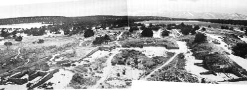 Figure 55. The pueblo of Quarai west of the church. This is the appearance of mounds H, I, and J after Hurt completed the clearing of the rubble from the outlines of the mounds in 1939. Courtesy Wesley Hurt. |
Excavations in the "Southeast Convento"
Wes Hurt, 1939-40
At the end of May, Hurt and the crew began excavating the remaining rooms extending south from the southeast corner of the east courtyard. They started where Baker had left off, at the south side of rooms 58 and 59, and the midpoint of room 51. Over the next seven months, Hurt carried the excavations to the south end of room 53 and two-thirds of the way across room 54. South of this point an irrigation ditch prevented further work in 1939.
By the end of July, 1939, most of the eastern area of the mission had been finished. The eastern courtyard and its associated rooms had been cleared, and most of the rooms in the southeastern area had been emptied of fill. In the southeast, the crew was still tracing some of the single walls enclosing what Hurt called "Patio 3," the open area between the east campo santo wall and the west side of the southeastern buildings.
In June, 1940, crewmen began work on the interior of the church. They removed and relayed much of the flagstone in the nave and transepts, probably because the original flagstones had shifted, making the flooring irregular and uncertain. [53] This relaying of the floor destroyed the arrangement of flagstone outlining the altar platforms in front of the two side altars, and the platform for the stairs to the main altar. At the same time, the workmen removed the decayed traces of the main altar steps, and built replacement steps across the mouth of the apse. These replacement steps were located about 3 feet north of the originals and were of the wrong riser and tread sizes.
In the first week of February, 1940, the crew finished excavating the known rooms of the southeastern area of the ruins. They removed the fill from the last few feet of room 54 and stabilized the walls. At the same time they apparently moved the irrigation ditch a few feet to the south so that it passed just south of the ruins. Finally, on August 9, Hurt and the crew packed up the equipment and left Quarai.
Albert Ely, 1944 and 1958
In October, 1944, Al Ely conducted stratigraphic tests at an unknown location in the pueblo of Quarai. He was teaching a class in archeology in Santa Fe, and gave the students field experience through two days of excavation during October 20-22. No known records of this excavation are available. [54]
Albert Ely returned to Quarai in 1958 to repair and re-stabilize the buildings. In order "to obtain clay for making mortar he uncovered six rooms" of the pueblo in mound J, as Wes Hurt puts it. Only a set of plan drawings of the rooms uncovered have been found. [55]
The "Chapel of 1629": Stubbs Excavations in 1959
In 1959 Stanley Stubbs excavated the "chapel" in the plaza just south of mound J. Stubbs found no artifacts in or around the church that allowed him to date it. He assumed that it had been built before the large church of Quarai, in about 1615-20. [56] Stubbs stated that the church outline had been "unrecognized for years by archaeologists and visitors at Quarai, and also not mentioned in any known Spanish record." However, the outline had been quite clear to Bandelier, who marked it on his plan of Quarai with the note "Chapelle," or chapel. [57] The archives of the Archdiocese of Santa Fe records the construction of a church at Quarai in 1829, stopped soon after it was begun. These two pieces of evidence show that Stubbs was wrong in his estimation of the age of the building. The date of its construction was probably 1829, and its walls never got much higher than about one foot.
Excavations in the Church and Convento
Valder, 1972
In 1972, the Museum of New Mexico carried out a major stabilization of Quarai. Assigned as field foreman was Timothy S. Valder, an archeologist. His wife, Linda Valder (also an archeologist), worked as photographer, records-keeper, and excavator, as well as working on the stabilization crew. In the process of room clearing and stabilization, the crew uncovered a number of previously unnoticed details about the structure and construction of the mission and convento. [58]
The Valders and their crew found several surviving pieces of wooden beams in the convento. While stabilizing and capping the south wall of the patio, one of the stabilization crew accidentally removed the charred remains of an upright beam from the wall west of the south doorway. The beam was apparently one of the original pillars that supported the open side of the ambulatorio before it was walled up. The beam was sent to "the lab," presumably the Laboratory of Anthropology. In the northeast room of the convento, while clearing out fill from the lower portion of the room, the crew found beam sockets on the north and south sides of the room. The socket on the south side was 9 1/2 inches across, horizontally, and 4 1/2 inches high. It originally contained two beams side by side; the badly decayed base of one of these still remained in place. The surviving chunk was only 2 3/4 inches in diameter. The Valders observed that the beams extended almost through the wall between room 11 and room 12 on the south, and that the ends of the beams had been covered with a thin layer of mortared stone from the south side of the wall. During stabilization, the holes on the north side of the room collapsed and were filled as solid wall. The west edge of the south socket pair was four feet four inches from the inner face of the southwest corner, and twenty-eight inches above the floor surface of the room as it existed in July, 1972. [59]
The Valders removed the flagstone from the platform in front of the church and from the interior of the building. [60] When they began on the platform, Linda recorded that the platform extended the width of the church facade from the front room of the baptistry on the west to the east edge of the facade, thirty-eight feet and two inches. The platform extended thirteen feet and nine inches from the front of the church. Traces of a second level or step just south of the south edge of the upper platform were visible in some places. Inside the church, as the flagstones came out the Valders noticed several post holes against the walls, previously covered by the stones. There were four of these, each about eleven inches in diameter and seven inches deep, with a rounded bottom. Two of the holes were in the southeast and southwest corners of the church interior, the third was sixteen feet six inches from the southeast corner against the east wall of the nave, and the fourth was sixteen feet from the southwest corner against the west wall. The Valders thought the posts that had stood here were to support the choir loft, but they were more likely main vertical supports for the scaffolding set up for the construction of the church in the seventeenth century. [61]
Beneath the flagstone floor of the church, the Valders found information about both the construction of the floor and the burial practices of the Franciscans who tended the mission. The Valders set up a seven-foot by nine-foot unit in the middle of the south half of the nave, and excavated to eighteen inches in six-inch levels. In this unit they found that the flagstones had rested on about three inches of brown loam, beneath which was a hard-packed, smooth surface. The hard-packed surface had been penetrated in a number of places, and scattered concentrations of re-deposited human bones were found everywhere in the test unit. The Valders hypothesized that the hard-packed floor had been the original surface inside the church, before the flagstones were installed. In actuality, it was probably the last "construction floor" within the church. When the construction crew finished the building, they then shoveled a thin layer of bedding clay onto the surface, and set the flagstones in place onto this clay. When it was necessary to bury someone, the missionary probably lifted two or three stones to uncover a patch of earth big enough for a grave, and then excavated a pit to contain the body. After the body was covered, the flagstones were lowered back into place. As the floor area filled with bodies, new graves reexcavated the old burials; the bones of the earlier burials were tossed back into the fill of the new graves. This is the typical sequence of events in a church that is used long enough to fill the favorite areas of the nave floor with graves. [62]
As bodies decayed, the flagstones would have settled unevenly over the graves, making the floor irregular. Whether the Franciscans ever felt the situation had gotten pronounced enough that they relevelled the floor cannot be determined.
1978 Stabilization Excavations
During the State stabilization of 1978, the Museum of New Mexico excavated a pit to examine the construction of the foundations of the church. The test pit was five feet long, and extended from the north face of the southwest tower, north along the west face of the west nave wall. The test found that the foundations of the church extended about seven feet below the present surface. The lowest 1 1/2 feet of foundation were built of cobbles, or water-smoothed stones. The next four feet of foundation were built with the same smooth veneer found on the above-grade walls. At about 1 1/2 feet below the present surface, the surface of the wall stepped back several inches, forming what the stabilization report called "a narrow footing." Above this footing, the veneer continued upward onto the above-grade wall surface. [63]
The veneered surface followed by this excavation must at some point become the surface stabilized into existence during the work by Senter in 1934. Senter's reports and field notes indicate that the stabilization had reveneered all of the wall surface below ten feet above grade. At least some part of the series of steps or setbacks built as part of the stabilization were a creation of the 1934 construction work. It is likely that the original surface had no setback, but dropped straight to the top of the footing, 1 1/2 feet below the ground surface. If so, then this footing would have originally been about 1 1/2 feet wide along the west side of the church.
ARCHEOLOGY AT LAS HUMANAS
Creation of the National Monument
Most of the pueblo of Las Humanas, including the two churches, was on federally-owned National Forest land. The interest in making these ruins into a National Monument grew throughout the 1890s, until the passage of the Antiquities Act of 1906. Among other things, the act authorized the President to establish National Monuments on lands belonging to the Federal Government. In 1908 the President was petitioned to make Gran Quivira a National Monument. [64] The proposal was accepted, and in 1909 the Federal government created Gran Quivira National Monument. In 1919, the boundaries of the park were enlarged to include the remainder of the pueblo ruins and management of the Monument entrusted to the National Park Service, created three years before. [65]
Excavations
In order to excavate and stabilize the ruins, the National Park Service made an agreement with the University of New Mexico, the School of American Research, and the Museum of New Mexico. Edgar L. Hewett was given supervision of the project. He put together a team of workmen and students, and set up camp at Gran Quivira in June, 1923. On Monday, June 25, the team began a detailed examination and mapping of the National Monument. Anna Shepard and Ida Squires completed the map of the pueblo and churches by July 6. Sam Hudelson and Frank "Boss" Pinkley (then superintendent of Casa Grande National Monument) began excavation in the church and convento of San Buenaventura in the third week of July. They worked on removing rubble from the sacristy, the baptistry and the front doorway, along the front of the church, and from around the mission walls in general. They also began the repair of some walls which were in particularly bad condition. By July 22, Hewett remarked that the church contained "considerably more debris than expected." The first season of work was completed by July 25. Pinkley, in a letter dated a few days later, indicated that they had not completed clearing rubble from within the church, and had not even begun on the convento rooms. [66] The excavations within the church used "as many men and teams as could work without interference," and no screening of fill or collecting of artifacts was conducted.
 Figure 56. San Buenaventura about 1920, taken from almost the same spot as Bandelier's photograph in 1883. The tremendous loss of wall fabric through the theft or, in a few cases, the decay of lintels, is obvious. Courtesy National Park Service. |
During 1924, Sam Hudelson and Dr. Wesley Bradfield spent most of the season working in the pueblo. Only the removal of debris along the east wall of the convento was carried out this year.
In 1925, work concentrated on the mission. Sam Hudelson and Frank "Boss" Pinkley worked on the convento from May 27 to June 10. During this time they cleared the rubble from rooms 4, 6, 8, 10, 12, and 14. A portion of the second courtyard was also emptied. On September 7, Hudelson returned with Hewett to continue working on the mission buildings. They cleared away rubble from the west and north exterior walls of the complex. Within the convento, they cleared out the patio, the south corridor, the "dining room," room 11, and part of room 2. They finished clearing the second courtyard. Work stopped on September 16.
1926 saw little work on the mission buildings. The clearing of room 2 was completed during September, and plans were made to convert room 1 to a museum.
The "excavation" of Gran Quivira was effectively completed in 1927 with the clearing of rubble from room 1 and the adjacent hall to the front entrance of the convento. No other archeologist investigated the convento or church until Charles Voll's work in the late 1960s.
Joseph Toulouse, the archeologist who excavated and stabilized San Gregorio de Abó, was appointed the third custodian of Gran Quivira on January 8, 1940, only a few months after completing his work at Abó in October 1939. [67] Toulouse took a dislike to the lack of proper names for the two mission structures on the hilltop and embarked on a program to get rid of the practice of referring to the buildings as "the Old Mission" and "the New Mission." Toulouse continued using these names through 1940 and most of 1941, but in a report prepared in September of 1941 he referred to the "Old Mission" as "San Ysidro." The "New Mission" was called simply "the Mission" in this report. Not until January of 1942 was "San Buenaventura" used in the records to indicate the "New Mission." It would appear that Toulouse found the references to the names of the missions in the writings of Charles Hackett and France Scholes sometime in 1940 or 1941, and decided to give the names to the two missions about September. [68]
 Figure 57. Excavation of the convento of San Buenaventura. This is room 16, probably in the summer of 1927. Courtesy National Park Service. |
Excavations in San Isidro
San Isidro remained an almost unrecognizable ruin through most of the first two decades of Park Service management. During the stabilization work conducted in 1942, Joe Toulouse excavated some of the sanctuary area of San Isidro while refilling a treasure-hunter's pit in the area where the main altar had been. He saw enough of the side altars to recognize them. [69] Not until 1951, however, was San Isidro excavated in its entirety. Along with his work in mound A, Gordon Vivian emptied the church of rubble and carefully exposed the surviving structural traces of the sanctuary area. [70] Vivian worked out a probable reconstruction of the sanctuary structures, a probable roofing method, and a probable construction history. The present report has reevaluated his conclusions, and disagreed with most of them. This does not lessen the importance or the quality of Vivian's work at San Isidro, but indicates that the general knowledge available to draw on has increased considerably since Vivian made his final revisions to the manuscript of Gran Quivira in 1953. [71] Since that time, the excavations of several seventeenth-century church sanctuaries has gathered a great deal of information on how these structures looked. Probably the most important single excavation was that of the Chapel of San Miguel in Santa Fe, published by Stanley Stubbs and Bruce T. Ellis in 1955. [72] The plan of the sanctuary area of the church as it was built in the early 1600s is almost identical to the plan of the sanctuary of San Isidro, built about the same time, with the exception that San Isidro is thirty percent larger in all dimensions. In the case of San Miguel, however, enough of the sanctuary was left to make it clear what the various structures were that stood there. This allowed a revision of Vivian's work, with the results presented in Chapter 7 of the present report.
Garland Gordon, 1962
During February of 1962, Garland Gordon excavated in the southeast corner of San Isidro, examining a circular arrangement of stone noticed by Caretaker Jack Kite. The excavation revealed that the stones were the top of a circular structure about two feet in diameter with a central hole about ten inches in diameter. The central hole widened to about fifteen inches in diameter and was excavated to a depth of about two feet. At this depth Gordon found a layer of ash. The fill of the hole was compacted clay with plaster fragments. [73]
Gordon called this structure a sacrarium, or holy water drain. The outside of the stone structure had been plastered at least twice, each time in three layers. The lowest layer was brown, the second white, and the third red. The same plaster layers were found on a finished floor surface to a distance of at least four inches from the sacrarium base. The hole had no plaster or detectable stonework.
Gordon excavated around the sacrarium for a distance of 1 1/2 feet to the west and north, and to the wall on the south and east. He found a finished floor throughout the area, with two surfaces. The lower was associated with the first layer of plaster on the sacrarium and was about seven inches below the present surface and the top of the sacrarium. The second floor surface, associated with the second plastering episode, was about 1 1/2 inches above the lower floor surface. Both plaster surfaces curved up to the sides of the sacrarium. Gordon speculated that the Franciscans had painted the entire sacrarium white, and then painted a red dado on the lower portion.
As part of the floor examination, Gordon cleared the floor toward the northeast to the edge of the main doorway. In the center of the south side of the doorway, Gordon found a rectangular stone feature perhaps one foot square which he thought might have been the masonry support for the pivot of the door. He did not examine the same point on the north side of the doorway.
Gordon said that the four stones on the floor at the east end were not bases for pillars, but covered post holes left by such pillars. He cited the observations of Jack Kite, who cleaned out the four holes himself during Vivian's excavation of San Isidro. [74]
On the recommendation of Regional Archeologist Charlie Steen, the floor was reburied and a replica of the sacrarium stonework was built above the original.
National Park Service Excavations in San Buenaventura
In 1951, Gordon Vivian summarized previous work within the church and convento of San Buenaventura. [75] The present report refined Vivian's summary somewhat, but still virtually no information about what was found in San Buenaventura from 1923 to 1930 can be recovered. No further effective excavations in the church and convento took place until the work of Charles Voll and Roland Richert in 1962. [76]
The work of Voll and Richert clearly revealed that the church, sacristy and baptistry of Las Humanas had never been finished. Their investigations defined the episodes of fill dumping within the retaining wall foundations outlining the complex. They showed how the foundations of individual rooms had been built in trenches excavated into the fill. Most important, they found the traces left by construction workers. The construction crew had abandoned a ten-foot-wide adobe puddling pit, piles of caliche and other materials in the sacristy, and left hard-packed "construction floors" throughout the church, sacristy, and baptistry. [77]
Voll and Richert followed the compacted "construction floor" from the sacristy doorway northward across the transept in one trench, and from the east side of the transept down the center of the church to the wall of the apse in a second trench at right angles to the first. The trenches found no indication of any structures in the sanctuary area, even though the packed "construction floor" was intact except for random treasure-hunter's holes. [78] The sum of the evidence collected by Voll and Richert shows beyond a reasonable doubt that San Buenaventura was not completed.
In 1986, the Park Service conducted additional excavations in the church. This was a single unit by Kate Spielman of the University of Iowa, Morgan Rieder working with the Historic American Buildings Survey, and the author. The unit was placed in the main entranceway of the church, and was intended to check statements made in 1923 by Anna O. Shepard and Ida Squires that there were steps here going down towards the interior. [79] Photographs taken at the time Shepard and Squires were at Las Humanas, or "Tabirá," as they called it, showed nothing that could be interpreted as steps, but the possibility required checking. [80]
The excavation revealed the irregular top of the foundation wall running beneath the entrance, a construction surface similar to that seen by Voll and Richert, and a postmold that appears to have been left by a scaffolding pole. The excavation found no indication of steps. [81]
Excavations in the Pueblo of Las Humanas
Several of the house mounds of Las Humanas have been sampled by archeology. The least productive of these tests were those conducted by Edgar L. Hewett and his students in the 1920s. Virtually no results of this work are on record, either published or as notes on file in the central collections at the University of New Mexico or the Museum of New Mexico. [82]
In 1951, Gordon Vivian excavated the house mound designated mound A. During March, April and May of 1951, he carefully emptied the rooms of the west half of the mound. This excavation was the first scientifically recorded work at Las Humanas, and the data gathered by Vivian was critical for the evaluation of Tompiro culture and the planning of later excavations. Vivian published his detailed report on these excavations in 1961. The report was reprinted in 1979.
Building on Vivian's work, Alden Hayes excavated all of mound 7 from 1965 to 1968. This excavation, published in two volumes of reports and analysis, forms the core block of data about Tompiro culture, architecture and archeology. In addition, Hayes's discovery of the Franciscan rooms at the west end of mound 7 produced the only detailed archeological information about the Franciscan method of establishing a mission at a pueblo. Without Hayes's work, much of the detailed deductions presented in the present report about the sequence of structural and historical events at Las Humanas could not have been possible.
The Identification and Excavation of Tabirá (Pueblo Blanco, LA 51)
Bandelier first attempted to identify the pueblo of Tabirá, based on references to it in the records available to him in the 1880s. He concluded that the pueblo of Las Humanas was Tabirá, a misidentification that persisted for almost fifty years. [83] In the mid-1930s, France Scholes, the foremost historian working on the colonial history of New Mexico, began to suspect that Bandelier's name for Gran Quivira was wrong and that the pueblo called Tabirá was still unidentified, somewhere in the general vicinity of Gran Quivira.
Scholes visited Gran Quivira in November, 1936, while examining pueblo ruins in the area. He appears to have been searching for the ruins of a church, attempting to find the true Tabirá. Scholes discussed his suspicions with George Boundey, who had become custodian of Gran Quivira in March. [84] Boundey agreed to examine some ruins that Scholes had not been able to locate, and to send Scholes a report on them. [85]
When he discussed his conversation with Scholes in his monthly report, Boundey outlined his impression of Scholes's position. Boundey stated that the documentary evidence implied that Gran Quivira was not Tabirá, but the "Mother Mission," with Tabirá a "smaller pueblo, a Visita of the Mother Mission." [86]
Boundey searched for physical evidence to support this idea for the next year and a half. Finally, in March, 1938, he found the place. In the Southwestern Monuments Monthly Report for that month he announced that, accompanied by one "Reverend Hillard," he had located the pueblo, and stated that the easily-recognizable church ruins were "the true church of Tiberia [Tabirá]." [87] Frank Pinkley, Regional Director at the time, disagreed with Boundey's identification, on the grounds that Tabirá should have two churches, one built in about 1630 and the other in about 1650. [88]
Boundey took a group of 21 people to his "church" site in June, 1938. The group was made up of professors and graduate students from the University of New Mexico. Boundey's report on this outing contained more details about the church (including estimates of its length, width and orientation), sacristy, and campo santo. [89] In spite of the doubts of Pinkley (and apparently everybody else who read his statement), Boundey turned out to be right: he had indeed located "the true church" of Tabirá.
In January, 1939, Joseph Toulouse wrote a brief summary of historical evidence pertaining to Gran Quivira, based on the recently published third volume of Historical Documents relating to New Mexico, Nueva Vizcaya, and Approaches Thereto, to 1773, translated and edited by Charles Wilson Hackett. [90] Here, Toulouse suggested that Gran Quivira National Monument was the place called "Las Humanas" in the documents, and that Tabirá and Las Humanas were the same place. Toulouse assumed this because both pueblos were said to have had churches in the records, and Toulouse knew of no other church in the area. [91] Toulouse then outlined the construction of the churches and the history of the pueblo in the Spanish colonial period along the same lines followed by France Scholes a year later. In November, 1940, after becoming the new custodian of Gran Quivira, Toulouse again summarized the current picture of the history of Las Humanas and Tabirá, incorporating the work of Kubler and Scholes firmly identifying Gran Quivira as Las Humanas. [92] In this summary, Toulouse proposed that "an Indian village east of Gran Quivira, not previously reported, yielding late sherds and majolica ware of the Spanish period," and containing "a small structure in one of the plazas which might be attributable [sic] to a small chapel," could be Tabirá. Toulouse had gotten this information, not from George Boundey, but from H. P. Mera. Mera had just completed his survey of the "Rio Grande Glaze Paint" area, and had noticed the ruins at the site he designated no. 51 (now LA 51, Pueblo Blanco), even though he did not mention them in the two papers he published in 1940, both briefly describing the site. [93]
The identification of Gran Quivira as Las Humanas by Kubler and Scholes in 1939 and 1940 cleared up many historical questions, but the question of the identity of Tabirá dropped from discussion until eighteen years later, in 1958. Channing Howell, then Superintendent of Gran Quivira, noticed George Boundey's remarks in the Gran Quivira files of Monthly Reports about a pueblo with a church ruin in the area of Las Humanas. He wrote to Boundey asking him for the name of the pueblo if he could remember it, its general location if he couldn't, and any other details he might recall about the place. [94] Boundey replied with his best recollection of the location of the pueblo, and promised to visit Gran Quivira in the fall to supply any further information he could. [95]
In September, 1958, Boundey stopped at Gran Quivira. Although he could not improve on his estimated location of the pueblo, he did apparently recall the name of one of the students who had accompanied him in his June, 1938, visit, a W. D. Crozier. Richard Howard, the archeologist at Gran Quivira at the time, took over the search for Tabirá. He wrote to Crozier, then at the New Mexico Institute of Mining and Technology, asking him for any further information about the pueblo. Crozier responded in late March, 1959, saying that he thought the name of the pueblo had been "Pueblo Blanco," and including a photograph of the church ruins taken in 1938. [96] In the meantime, Howard had visited Pueblo Blanco on March 9, feeling that it was one of the most likely candidates to be the pueblo described by Boundey. He returned from the visit convinced that the ruin in the plaza of the pueblo was that of a church. [97]
During Howard's visit in March, 1959, he found that treasure hunters had uncovered a portion of the west end of the "peculiar" pueblo ruin. Howard scraped rubble from adjoining wall tops and found that the place was almost certainly a Spanish-built structure, probably a church. He was able to sketch the outlines of the church, sacristy, and campo santo, and even to recognize a structure at the west end of the church, in the area he identified as the apse, that later turned out to be the altar. [98]
Howard requested that the Park Service plan to excavate the church. In response, Stanley Stubbs of the Laboratory of Anthropology of the Museum of New Mexico visited the site. He decided that Boundey and Howard had been correct: there was indeed a church in the plaza of Pueblo Blanco. Stubbs arranged a permit with the Department of Agriculture for excavation in Cibola National Forest, where the site was located, and began digging on June 8, 1959, with Howard assisting. The field work was completed on June 14, and Stubbs published the results in El Palacio. [99] In April, 1960, Howard published a historical assessment of the site, offering documentary evidence that the church must logically be that of San Diego de Tabirá. This has since been accepted, and the ruins of Pueblo Blanco are now also called "Tabirá." [100]
The results of Stubb's excavations have been reevaluated in the present report, in light of the revised sequence of construction events at Las Humanas in 1629-32, 1634-36, and 1659-61, presented in chapters 6 and 10. The structural events imply that the three episodes of construction Stubbs identified at San Diego de Tabirá should be: 1) the construction of the foundations and the first two or three feet of wall by Fray Francisco Letrado in 1630-31, during which Letrado built no internal structures such as altars; 2) completion of the church in 1634-36 by Fray Francisco de Acevedo, including the first altar; and 3) the renovation of the building in 1660-61 or later by Fray Diego de Santandér or his successors. This is hypothetical, of course, and may be revised as more archeological or documentary information becomes available. For example, it is quite possible that Acevedo could have carried out the construction of both versions of the complete church, first in 1634-36 and then during the "resurgence" of the 1650s.
| <<< Previous | <<< Contents>>> | Next >>> |
sapu/hsr/chap10.htm
Last Updated: 28-Aug-2006