|
Sleeping Bear Dunes National Lakeshore Michigan |
|
 NPS photo | |
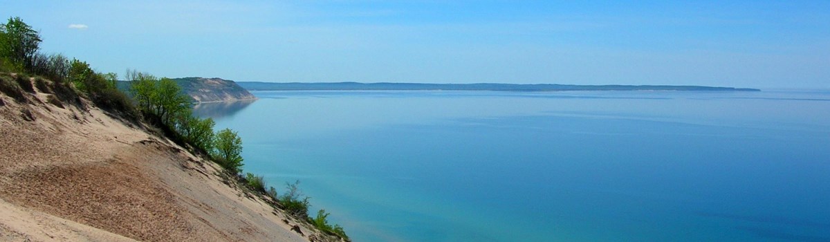
On the northwestern shore of Michigan's Lower Peninsula lies Sleeping Bear Dunes National Lakeshore, a hilly region fringed with massive shoreline sand dunes and dotted with clear lakes. It is a diverse landscape, embracing quiet, birch-lined streams, dense beech-maple forests, sandy beaches, and rugged, glacially formed bluffs towering as high as 460 feet (140 meters) above Lake Michigan. Offshore, surrounded by the unpredictable waters of Lake Michigan, sit North and South Manitou islands, tranquil and secluded.
For thousands of visitors each year, Sleeping Bear Dunes offers a wealth of opportunities to enjoy the outdoors. Many come to play at the Dune Climb or to savor sweeping views of land and water from the park's roadways. Others come to hike the trails, where they find a rich variety of wildflowers, mammals, and birds. Beachcombers can enjoy a walk along Lake Michigan's shore, pausing occasionally to examine an interesting pebble or shell. Canoeing down a slow-flowing stream offers a quiet, intimate look at the countryside. Fishing fervor peaks in the fall, when coho and king salmon, fish introduced from the Pacific, return to the Platte River to spawn. In winter, cross-country skiers tour snowy woodlands. The possibilities for relaxation and challenge are almost unbounded.
There were many people whose lives were tied to this land long before it became a parkland—Indians, lumbermen, merchant sailors, farmers. Glen Haven and the Manitou islands were once busy communities supplying lumber for the construction of towns as far away as Chicago, III. They also supplied fuel to wood-burning ships that sailed the Great Lakes during the latter half of the 1800s and early 1900s. Ruins of sawmills and fueling docks can still be seen. Crop farming followed the cutting of the forests, but it, like lumbering, soon faded. Many farmers abandoned their fields, leaving them to return to their natural state. Orchard growers had more lasting success growing cherries and apples. Many fruit trees still grow in the park and nearby.
The South Manitou Island Lighthouse was built in 1871 to guide ships through the Manitou Passage and into the island's harbor when fierce lake storms broke. Despite such safeguards, many ships still ran aground. The ruins of the wrecked freighter Francisco Morazan can be spotted off South Manitou's south shore. The lifesaving stations at Glen Haven and South Manitou Island are reminders of earlier times, when rescue crews launched small oar-powered wooden boats into giant waves to save shipwreck survivors. Today the Sleeping Bear Dunes area thrives as a popular summer resort area.
Long ago, in the land that is now Wisconsin, a mother bear and her two cubs were driven into Lake Michigan by a raging forest fire. They swam and swam, but soon the cubs tired and lagged far behind. Mother bear finally reached the opposite shore and climbed to the top of a bluff to watch and wait for her offspring. But the cubs drowned. Today "Sleeping Bear," a solitary dune in Michigan overlooking Lake Michigan, marks the spot where mother bear waited. Her hapless cubs are the Manitou islands.
—Chippewa Indian legend
A Masterpiece of Ice, Wind, and Water
Indians were the first to tell tales of how sand dunes and other features of the land were created. In more recent years scientists have sought to explain the complex geologic history of the area. An abundance of clues has helped.
Fossils tell of some of the earliest history, when shallow warm seas covered this area. More recent history is revealed in the landscape. The shoreline, the hills and valleys, the many small lakes, and the sand dunes you see today are evidence that the powerful earth-moving forces of ice, wind, and water have been at work here. Often, geological changes occur slowly over millions of years, but here you can witness dramatic changes within your lifetime. Twice in the last century landslides at Sleeping Bear Point sent large land masses plunging into Lake Michigan. In a matter of years, trees disappear as shifting dunes bury them under a blanket of sand. Such changes make Sleeping Bear Dunes an exciting place to visit and revisit.
During the Ice Age continental glaciers spread southward from Canada, repeatedly burying this area under sheets of ice. These massive glaciers enlarged river valleys, carving out the wide, deep basins of the Great Lakes. They deposited huge piles of sand and rock debris when they melted, leaving behind the hilly terrain you see today. Finally, 11,800 years ago, the last glacier retreated.
With the glacial landscape formed, Lake Michigan and many smaller lakes began to take shape. The level of water filling Lake Michigan's ice-carved basin rose and fell many times before reaching its present level. The lake's shoreline—at first irregular with jutting headlands and recessed bays—was gradually smoothed out. Waves wore back the headlands. Shoreline currents carrying sediments built sandbars and spits across bay mouths. Sometimes sediments dammed bays, creating small inland lakes such as Glen Lake near the Lake Michigan shoreline. Receding Lake Michigan water levels have left a series of old beach lines that remain as alternating and contrasting low ridges and swales.
The glaciers left behind an ideal setting for building sand dunes: a sandy coast on the windward side of Lake Michigan. Prevailing westerly winds blowing across the lake build two kinds of dunes in Sleeping Bear Dunes. Beach dunes develop on low-lying shores of Lake Michigan. Their main ingredient is beach sand. The Aral Dunes, along Platte Bay's north shore, are good examples of beach dunes. Perched dunes, on the other hand, sit high above the shore on plateaus. Glacial sands atop these surfaces supplied material for these dunes. The Sleeping Bear Dune of Indian legend is a perched dune.
Some dunes migrate, pushed by the wind. Sometimes shifting sands bury trees. Then, as the dunes move on, "ghost forests" of dead trees are exposed, stark reminders of the dunes' passing. Not even humans have escaped the influence of windblown sand. U.S. Coast Guard buildings now located in Glen Haven had to be moved from Sleeping Bear Point in 1931 because migrating dunes threatened to cover them.
Beachgrass and sand cherry are among the first plants to grow on newly built dunes. They play an important role in dune development. They help build dunes by acting as obstacles that slow sand-laden wind and force it to drop its load. Their roots hold sand in place and stabilize dunes. But if a strong wind succeeds in stripping plants from a dune, a bowl-shaped blowout can be excavated in the exposed area. Vehicles are prohibited on the dunes because they destroy dune vegetation. Tire-track scars last many years.
An Ever-Changing Scene
Lake Michigan Overlook on Pierce Stocking Scenic Drive offers views of the lake and the dunes.
Cleared forest lands became small farms and orchards; many were later abandoned.
South Manitou lighthouse, which once guided storm-tossed ships, now sits idle.
Lake Michigan may be calm one moment, then suddenly unleash its fury in a storm.
The north woods wilderness of the Platte River unfolds as canoeists glide leisurely past.
Beech-maple forests celebrate autumn's arrival with a breathtaking show of color.
Visiting the Lakeshore
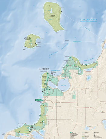 (click for larger map) |
The Philip A. Hart Visitor Center offers exhibits, a slide program, and book sales. Park headquarters, in the same building, is open weekdays. Exhibits are also at the Maritime Museum, outdoor mainland locations, and on South Manitou Island.
The Pierce Stocking Scenic Drive
This 7.1-mile (11.4-kilometer) route offers panoramic views of Sleeping Bear
Dunes, Glen Lake, and Lake Michigan. It is open late April to early November,
weather permitting. Trailers are prohibited on this drive because the parking
areas do not have pull-through parking spaces. Bicycles are permitted.
Exploring the Dunes
Climbing to the top of Sleeping Bear Dunes at the Dune Climb is strenuous but
rewarding. From the crest you can view Glen Lake. You can also hike the Dunes
Trail, a 3.5-mile (5.6-km) round trip, or walk a 2.8-mile (4.5-km) loop trail to
Sleeping Bear Point. The dunes cover about four square miles (10.4 square km).
No water or shelters are provided. Watch your children; it is easy to get lost
in this expanse of sand. All hikers should use a map and plan a route
beforehand. Wear shoes to protect your feet. Stay on designated trails to
prevent erosion and damage to vegetation.
>Hiking Trails
Many trails lead through forests and meadows. Trail maps are available at the
visitor center and are posted at trailheads. Some of the land within park
boundaries is private property; please respect owners' rights.
Hunting
There are hunting seasons throughout the year; wear bright clothing whenever you
are hiking or skiing. Deer, rabbit, squirrel, ruffed grouse, and waterfowl
hunting is allowed in season under state regulations. Special park regulations
prohibit hunting near the Pierce Stocking Scenic Drive when the drive is
open.
Enjoying the Water
The park's lakes and rivers offer opportunities for swimming, boating, and
fishing. Canoes can be rented on the Platte and Crystal rivers. Anglers with a
Michigan license can fish for trout, pike, bass, and salmon. Certain fish may be
contaminated and should be eaten in limited amounts or not at all. Check the
Michigan Fishing Guide for details.
South Manitou Island
Points to visit include the huge white cedar trees, the lighthouse, and historic
sites. Ferry service from Leland is available May to mid- October.
North Manitou Island
Hikers and backpackers can explore 15,000 acres (5,070 hectares) of wilderness.
Ferries leaving Leland are available on a regular basis June through August;
limited service is available in May and in September through mid-November.
Winter Recreation
About 50 miles (80 km) of trails are marked for cross-country skiing. Get a map
at the visitor center, headquarters, or a trailhead. Snowmobiling is prohibited
except on rights-of-way along some state and county roads.
Camping
Platte River Campground is open year round, with reservations available for
one-third of the campsites from Memorial Day to Labor Day. The remaining
campsites are available on a first-come, first-served basis. D. H. Day Campground
is open from April through November, with all campsites available on a
first-come, first-served basis. Contact the park for exact dates. D. H. Day has
water and vault toilets. Platte River has showers, flush toilets, water, and a
few sites with electrical hookups. Camping is limited to 14 days. A fee is
charged. Groups can reserve campsites at a group campground near Glen Lake
Picnic Area or at Platte River Campground. Backcountry camping, by permit only,
is allowed at walk-in campgrounds on the mainland and on both Manitou Islands.
Permits are available at the visitor center in Empire or at ranger stations.
Accommodations
Most motels and cottages are open only in summer; reservations are recommended.
For lodging information, write: Glen Lake Chamber of Commerce, Box 217, Glen
Arbor, MI 49636; Benzie County Chamber of Commerce, Box 505, Beulah, MI 49617;
or Leelanau County Chamber of Commerce, 5046 S. West Bay Shore Drive, Suttons
Bay, MI 49682.
The Climate
Summers are cooler and winters milder along the lakeshore than in inland areas
because of Lake Michigan's moderating influence. From June through August daily
maximum temperatures range between 70 and 90°F (21 and 32°C). In winter
temperatures below 0°F (-18°C) are recorded only a few days each year,
but the wind makes it feel colder. Most precipitation falls as snow, which
averages 100 inches (254 cm) along the shore; inland accumulation is higher.
For a Safe Visit
• Sand dunes, like snow drifts, can be unstable. Landslides sometimes
occur. • Do not dig holes deep enough to bury someone. • Do not dig in
sand at the base of a dune. • Do not descend steep slopes where rocks or
sand could dislodge and injure someone. • Do not cross steep snow-covered
dunes. Big snowdrifts can avalanche. • Hunting is permitted within the
Lakeshore. Hikers are reminded to wear brightly colored clothing during hunting
season, especially during firearm deer hunting season (November 15-30).
Practice Safe Boating
• Boaters should monitor weather reports. Conditions on Lake Michigan can
deteriorate rapidly and become hazardous even to large boats. • Carry
safety gear and extra fuel in case a storm develops. • For detailed
navigational information on nearby waters of Lake Michigan, obtain National
Ocean Survey charts 14907 and 14912. • Lake and stream water may be
contaminated. Boiling water for at least a minute will kill most germs but won't
remove chemical pollutants.
Regulations
• Do not drive off established park roads. • Always keep your pet on a
leash. • Pets are not allowed at North Bar Lake, on the Manitou islands, in
backcountry campgrounds, on the Dune Climb, or on the swimming beaches. •
Pets on a leash (no more than six feet long) are permitted on all hiking trails
between April 1 and November 30. • Camp only in campgrounds. • Fires
are permitted in campground fire rings and in picnic area fireplaces. •
Beach fires are restricted to bare beach sand between the water and the first
dune and are not permitted on the Manitou Islands. • Do not collect
ghost-forest wood or other wood on the dunes or disturb any plants or natural
objects. Campers can collect dead and down wood elsewhere. • You may pick
mushrooms and fruit for personal use. • Bicycles are not permitted off the
roads. • All glass containers and products are prohibited on any land or
water area used for sunbathing, swimming, or wading. • Horses are permitted
only on the Alligator Hill Hiking Trail.
Poison Ivy
Avoid its three leaflets, stems, and roots; all can cause allergic reaction.
Getting to the Park
Many north-south highways approach the park, including U.S. 31 along Lake
Michigan, U.S. 131 through Grand Rapids, and I-75, which runs the length of the
state into the Upper Peninsula. U.S. 31 connects with Mich. 22, the main road
through the park. Two east-west routes, Mich. 115 (to Frankfort) and Mich. 72
(through Traverse City to Empire), also lead to Mich. 22.
Source: NPS Brochure (2004)
|
Establishment Sleeping Bear Dunes National Lakeshore — October 21, 1970 |
For More Information Please Visit The  OFFICIAL NPS WEBSITE |
Documents
A Garden Apart: An Agricultural and Settlement History of Michigan's Sleeping Bear Dunes National Lakeshore Region (Susan Olsen Haswell and Arnold R. Alanen, 1994)
A Multi-scale Assessment and Evaluation of Historic Openlands at Sleeping Bear Dunes National Lakeshore NPS Natural Resource Technical Report NPS/GLKN/NRTR-2009/150 (R. Gregory Corace, III, P. Charles Goebel and Thomas C. Wyse, January 2009)
A Nationalized Lakeshore: The Creation and Administration of Sleeping Bear Dunes National Lakeshore (HTML edition) (Theodore J. Karamanski, 2000)
A Proposed Sleeping National Seashore: Natural History Report (1961)
A Report of Feasibility of Two Areas in Sleeping Bear Dunes National Lakeshore (Paul H. Risk, undated)
A Special History Study of Port Oneida and the Pyramid Point Agricultural District, Sleeping Bear Dunes National Lakeshore, Michigan (Ron Cockrell, April 1983 rev. June 1984)
Acoustic Amphibian Monitoring, 2019 Data Summary: Sleeping Bear Dunes National Lakeshore NPS Natural Resource Data Series NPS/GLKN/NRDS-2022-1379 (Gary S. Casper, Stefanie M. Nadeau and Thomas B. Parr, December 2022)
Acoustic Monitoring for Bats at Sleeping Bear Dunes National Lakeshore: Data Summary Report for 2015–2019 NPS Natural Resource Data Series NPS/GLKN/NRDS—2021/1323 (Katy R. Goodwin and Alan A. Kirschbaum, April 2021)
Acoustic Monitoring Report, 2022: Sleeping Bear Dunes National Lakeshore NPS Science Report NPS/SR-2025/257 (Tyra A. Olstad, March 2025)
Amphibian and Reptile Monitoring in the Great Lakes Network National Parks: Review and Recommendations Report GLKN/2004/03 (Gary S. Casper, June 30, 2004)
An Amphibian and Reptile Inventory of Sleeping Bear Dunes National Lakeshore NPS Natural Resource Technical Report NPS/GLKN/NRTR-2008/147 (Gary S. Casper and Thomas G. Anton, December 2008)
Annual Performance Report: FY2003, Sleeping Bear Dunes National Lakeshore (Dusty Shultz, October 28, 2003)
Annual Performance Report: FY2004, Sleeping Bear Dunes National Lakeshore (Dusty Shultz, October 31, 2004)
Aquatic Studies in National Parks of the Upper Great Lakes States: Past Efforts and Future Directions NPS Technical Report NPS/NRWRD/NRTR-2005/334 (Brenda Moraska Lafrancois and Jay Glase, July 2005)
Assessment of Alternatives: General Management Plan, Sleeping Bear Dunes National Lakeshore, Michigan (August 1979)
Assessment of Natural Resource Conditions, Sleeping Bear Dunes National Lakeshore NPS Natural Resource Report NPS/NRPC/WRD/NRR-2009/097 (Christine Mechenich, David J. Mechenich, Stanley W. Szczytko, James E. Cook and George J. Kraft, March 2009)
Baseline Water Quality Data Inventory and Analysis, Sleeping Bear Dunes National Lakeshore NPS Technical Report NPS/NRWRD/NRTR-97/106 (March 1997)
Bat Monitoring Protocol for the Great Lakes Inventory and Monitoring Network — Version 1.0 (NPS Natural Resource Report NPS/GLKN/NRR-2020/2126 (Katy G. Goodwin, May 2020)
Bioaccumulative Contaminants in Aquatic Food Webs in Six National Park Units of the Western Great Lakes Region: 2008-2012 NPS Natural Resource Report NPS/GLKN/NRR-2016/1302 (James G. Wiener, Roger J. Haro, Kristofer R. Rolfhus, Mark B. Sandheinrich, Sean W. Bailey and Ried M. Northwick, September 2016)
Biogeographic Patterns of Inland Lake Fish Communities at Isle Royale, Voyageurs, and Sleeping Bear Dunes National Park Units NPS Natural Resource Technical Report NPS/GLKN/NRTR—2014/893 (Owen Gorman, Larry Kallemey, and Ryan Maki, July 2014)
Briefing Paper on the Resource Preservation Areas, Sleeping Bear Dunes National Lakeshore (January 1980)
Climate Change Impacts on Odawa Contemporary Use Plants and Cultture at Sleeping Bear Dunes National Lakeshore (Richard Stoffle, Katherine Brooks, Evelyn Pickering, Christopher Sittler and Kathleen Van Vlack, October 5, 2015)
Climate Change Scenario Planning Workshop Summary, Apostle Islands National Lakeshore, April 23-24, 2015 (Jonathan Star, Nicholas Fisichelli, Gregor Schuurman, Leigh Welling, Richard Rood and Laura Briley, 2015)
Coastal Hazards Assest Vulnerability Assessment for Sleep Bear Dunes National Lakeshore: Summary of Results NPS 634/195672 (B.R. Tormey, K.M. Peek, H.L. Thompson and R.S. Young, January 2025)
Coming Through With Rye: An Historic Agricultural Landscape Study of South Manitou Island at Sleeping Bear Dunes National Lakeshore, Michigan (Brenda Wheeler Williams, Arnold R. Alanen and William H. Tishler, 1996)
Cultural Landscape Report: Glen Haven Village Historic District (2007)
Cultural Landscapes Inventory: Bournique Homestead, Sleeping Bear Dunes National Lakeshore (2014)
D. H. Day's Kingdom: A Special History Study of Glen Haven Village Historic District, Sleeping Bear Dunes National Lakeshore, Michigan (Ron Cockrell, 1984)
Development Concept Plan, Interpretive Prospectus: Glen Haven Area, Sleeping Bear Dunes National Lakeshore, Michigan (Draft, April 1987)
Development Concept Plan, Interpretive Prospectus: Glen Haven Area, Sleeping Bear Dunes National Lakeshore, Michigan (November 1992)
Development Concept Plan: North Manitou Island, Sleeping Bear Dunes National Lakeshore, Michigan (Draft, February 1987)
Draft General Management Plan, Sleeping Bear Dunes National Lakeshore, Michigan (August 1979)
Draft General Management Plan: Executive Summary, Sleeping Bear Dunes National Lakeshore, Michigan (August 1979)
Effects of Climate Change and Atmospheric Nitrogen Deposition on Forest Understory Vegetation Communities in Selected U.S. National Parks NPS Science Repport NPS/SR-2024/169 (Todd C. McDonnell, Brian Knees, Michael D. Bell and Emmmi Felker-Quinn, August 2024)
Farming at the Water's Edge: An Assessment of Agricultural and Cultural Landscape Resources in the Proposed Port Oneida Rural Historic District at Sleeping Bear Dunes National Lakeshore (Marla J. McEnaney, William H. Tishler and Arnold R. Alanen, 1995)
Forests and Dunes from Point Betsie to Sleeping Bear, Benzie and Leelanau Counties, Michigan (W.G. Waterman, 1972)
Foundation Document Overview, Sleeping Bear Dunes National Lakeshore, Michigan (January 2016)
Friends of Sleeping Bear Dunes Annual Newsletter: Spring 1995 • April 2014 • December 2014 • 2012 • 2015 • 2016 • 2017 • 2020-2021 • 2022 • 2023
General Management Plan, Sleeping Bear Dunes National Lakeshore, Michigan (October 1979)
General Management Plan/Wilderness Study/Environmental Impact Statement, Sleeping Bear Dunes National Lakeshore (Final, October 2008)
Geologic Report on Sleeping Bear Dunes National Lakeshore (Christopher Drexler, 1975)
Glen Haven and the Maritime Museum (May 2023)
Great Lakes Junior Ranger Activity Book (Date Unknown; for reference purposes only)
Historic Furnishing Report: Sleeping Bear Point Life-Saving Station, Sleeping Bear Dunes National Lakeshore (Katherine B. Menz, 1983)
Historic Resource Study, Sleeping Bear Dunes National Lakeshore (Jim Muhn, 1984)
Historic Structure and Cultural Landscape Report: South Manitou Island Light Station (Historic Structures 51-120 A-I), Sleeping Bear Dunes National Lakeshore (Final Report, Quinn Evans Architects, January 29, 1999)
Historic Structure Report: Glen Haven Coast Guard Station, Sleeping Bear Dunes National Lake Shore: Architectural and Historical Data (Cornelia Wyma and John Albright, April 1980)
Impacts of Visitor Spending on the Local Economy: Sleeping Bear Dunes National Lakeshore, 2009 NPS Natural Resource Report (Philip S. Cook, May 2011)
Implementation of a Long-Term Vegetation Monitoring Program at Sleeping Bear Dunes National Lakeshore NPS Natural Resource Report NPS/GLKN/NRTR-2010/407 (Suzanne Sanders and Jessica Grochowski, November 2010)
Inventory and Evaluation of Inland Fisheries at Sleeping Bear Dunes National Lakeshore Great Lakes Network Report GLKN/2007/03 (Brett Fessell, November 2007)
Junior Ranger Book, Sleeping Bear Dunes National Lakeshore (Date Unknown; for reference purposes only)
Junior Ranger Workbook, Sleeping Bear Dunes National Lakeshore (1992)
Landsat-based Monitoring of Landscape Dynamics at Sleeping Bear Dunes National Lakeshore: 2006–2011 NPS Natural Resource Report NPS/GLKN/NRR—2014/895 (Alan A. Kirschbaum and Ulf B. Gafvert, December 2014)
Leelanau Scenic Heritage Route Trailway Plan and Environmental Assessment, Sleeping Bear Dunes National Lakeshore, Leelanau County, MI (Gosling Czubak Engineering Sciences, Inc., National Park Service and Northwest Michigan Council of Governments, March 2009)
Long-Range Interpretive Plan, Sleeping Bear Dunes National Lakeshore (September 2011)
Master Plan: Sleeping Bear Dunes National Lakeshore, Michigan (1970)
Monitoring Visitor Reactions to the Recreational Fee Demonstration Program in Sleeping Bear Dunes National Lakeshore in 1999: A Summary of Output (Jerrilyn L. Thompson, David W. Lime, Joanna M. Rosendahl and Cynthia A. Warzecha, April 7, 2000)
Monitoring Water Quality of Inland Lakes
Monitoring Water Quality of Inland Lakes, 2008: Annual Summary Report Great Lakes Inventory and Monitoring Network Report GLKN/2008/01 (Joan Elias, February 2009)
Monitoring Water Quality of Inland Lakes, Great Lakes Network, 2009 and 2010: Data Summary Report NPS Natural Resources Data Series NPS/GLKN/NRDS-2011/163 (Joan E. Elias and Richard A. Damstra, May 2011)
Monitoring Water Quality of Inland Lakes, Great Lakes Network, 2011: Data Summary Report NPS Natural Resources Data Series NPS/GLKN/NRDS-2012/363 (Joan E. Elias and Richard A. Damstra, September 2012)
Monitoring Water Quality of Inland Lakes, Great Lakes Network, 2012: Data Summary Report NPS Natural Resources Data Series NPS/GLKN/NRDS-2014/629 (Richard A. Damstra, David Vander Meulen and Joan Elias, March 2014)
National Register of Historic Places Nomination Forms
George Conrad Hutzler Farm (Jill York O'Bright, October 22, 1986)
Glen Haven Village Historic District (Ron Cockrell, Thomas Hensley, Marie Scott and Pat McCauley, November 22, 1982, April 14, 1989, November 6, 1989)
Hutler's Barn (David Koenig, October 21, 1976)
North Manitou Island Lifesaving Station (William Herd and Kimberly Mann, January 26, 1994)
Platt River Camground (Cathie Masters, October 23, 1989)
Port Oneida Rural Historic District (Marla J. McEnaney, December 31, 1996)
Sleeping Bear Inn (HS-23) (David Koenig, October 21, 1976)
Sleeping Bear Point Life Saving Station (David Koenig and F.A. Ketterson, Jr., October 21, 1976, revised September 1978)
South Manitou Island Lighthouse Complex / Life-Saving Station Historic District (Jill M. York, June 9, 1983)
Natural History Values of Selected Areas, Sleeping Bear Dunes National Lakeshore Park Region (Warren H. Wagner, undated)
Our Fourth Shore: Great Lakes Shoreline (HTML edition) (1959)
Park Newspaper (Visitor Guide): 2000 • 2006 • 2007 • 2008 • 2009 • 2011 • 2012 • 2013 • 2014 • 2015 • 2016 • 2017 • 2018 • 2019
Platte River Management Plan: Sleeping Bear Dunes National Lakeshore, Michigan (August 1992)
Popular Beach Disappears Underwater in Huge Coastal Landslide—Sleeping Bear Dunes, Michigan USGS Fact Sheet 020-98 (Bruce Jaffe, Robert Kayen, Helen Gibbons, James W. Hendley II and Peter H. Stauffer, 1998)
Port Oneida Historic Landscape Management Plan / Environmental Assessment, Sleeping Bear Dunes National Lakeshore (August 2011)
Reconnaissance Report on Several Locations Adjacent to the Sleeping Bear Dunes National Lakeshore (Richard W. Pippen, undated)
Remaining Shoreline Opportunities in Minnesota, Wisconsin, Illinois, Indiana, Ohio, Michigan, Pennsylvania, New York: A Report Prepared by the Great Lakes Shoreline Recreation Area Survey (HTML edition) (1959)
Report of Visit to Sleeping Bear Dune and Adjacent Areas (William R. Farrand, October 22, 1979)
Resource Information Base, Sleeping Bear Dunes National Lakeshore, Michigan (August 1979)
Scenic Road Feasibility Study, Sleeping Bear Dunes National Lakeshore, Michigan (1982)
Scope of Collections Statement, August 15, 2011 (Laura Quackenbush, 2011)
Soil Survey of Sleeping Bear Dunes National Lakeshore, Michigan (2013)
Songbird Monitoring in the Great Lakes Network Parks: 2014-2018 NPS Natural Resource Report NPS/GLKN/NRR-2021/2217 (Samuel G. Roberts, Zachary S. Ladin, Elizabeth L. Tymkiw, W. Gregory Shriver and Ted Gostomski, January 2021)
Strategic Plan for Sleeping Bear Dunes National Lakeshore, October 1, 2005-September 30, 2008 (c2005)
Tending a "Comfortable Wilderness": A History of Agricultural Landscapes on North Manitou Island, Sleeping Bear Dunes National Lakeshore (Eric MacDonald and Arnold R. Alanen, 2000)
The Importance of Climate Change, Sleeping Bear Dunes National Lakeshore: Site Bulletin (undated)
The Natural History of Bow Lakes — Wetlands, glacial valley, ice block kettle and Miller Hill portion of the Sleeping Bear Dunes National Lakeshore (Donald L. Tilton, undated)
Unusual Features of the Upland Sector of Sleeping Bear Dunes (Paul W. Thompson, undated)
Visitor Study, Sleeping Bear Dunes National Lakeshore: Summer 2009 Park Studies Unit Visitor Services Project Report 216 (Nancy C. Holmes, Eleonora Papadogiannaki, Douglas Eury and Steven J. Hollenhorst, April 2010)
Water Resources Management Plan, Sleeping Bear Dunes National Lakeshore, Michigan (David L. Vana-Miller, November 2002)
slbe/index.htm
Last Updated: 22-Mar-2025