|
National Forests of Wyoming Miscellaneous Circular No. 82 |
|
NATIONAL FORESTS OF WYOMING
NORTHERN WYOMING
BIGHORN NATIONAL FOREST
South of the Crow Indian Reservation and across the Big Horn Valley from the Shoshone National Forest lies the Bighorn National Forest, an area of more than 1,125,000 acres extending 80 miles in a southeasterly direction from the Montana-Wyoming line along the Big Horn Mountains. This is a wild stretch of country where game abounds in natural haunts that have been the home of their ancestors for uncounted ages. This region was a famous hunting ground of the Sioux, Crow, and Cheyenne Indians before the coming of the white man, and was the scene of many bloody battles in early Indian campaigns.
The Big Horn Peaks, which rise more than 13,000 feet above sea level and mark the crest of the forest, were objects of veneration in the religious life of the Indians. Back into those rugged, snow-capped, enveloping solitudes the prehistoric American went to make or find his "medicine". Relics of these rites remain to pique the imagination of those wandering over these mountains to-day.
Just as the mountains are the backbone of the region geographically, the resources of the national forests have come to be the backbone of the region economically. Because of the close relation between forest ranges, timber, and water and surrounding ranches, this forest is regarded locally with a great degree of proprietary interest. Individuals and organizations cooperate freely and generously in developing improvements which increase the usefulness of the forest resources, and support a volunteer fire-fighting organization which is of the greatest importance in keeping out forest fires. Such understanding is of more than casual value to the Forest Service in its work. The development of the timber industry on a large scale will come eventually and when it comes, in addition to providing for the harvesting of a large annual growth of timber, will contribute in still other ways to the economic prosperity of the surrounding towns.
It is part of the policy of national forest administration to make the various forest units community assets as well as national assets. The grazing facilities of the forest have been handled in such a way that they have become an essential factor in the livestock industry, which for years has been of major importance in this locality. In all, probably 400 ranch owners depend on the Bighorn National Forest for summer range. The forest also furnishes a considerable amount of wood for use on these same ranches, which, in addition, derive their water supply from streams rising in the mountains within the forest boundaries.
|
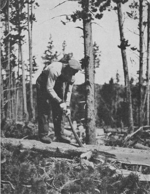
| FIG. 17.—Hewing a tree with a broadax, Bighorn National Forest (F-187534) |
FOREST RECREATION
As is frequently the case, the value of this national forest as a community asset is felt far beyond the limits of the near-by valleys. In recent years the Bighorn, like nearly all the other national forests, has been called upon for a fourth type of service. During these years the people of the United States have learned to play out-of-doors. The automobile and extensive road building have resulted in an almost universal hunt for the open. In the course of this hunt the national forests have been "discovered," and camps, summer homes, and resorts are now found in practically all of them.
Residents in the vicinity of the Bighorn National Forest are annually hosts to thousands of vacationists from all over the United States, and through their hospitality place at the disposal of these visitors a region ideally adapted to outdoor recreation. And they do it with just pride, for they have taken a personal interest in the development of the forest and the fitting in of this use on appropriate areas so as not to conflict with the other uses of the forest. This is not restricted to the Bighorn, but is characteristic in varying degree of every national forest.
Several towns and organizations have established camp grounds and lodges. The Sheridan Municipal Mountain Park, at Woodrock, on the South Fork of Tongue River, is one of these. A large camp ground is also being improved by the Custer Battlefield Highway Association on North Tongue River, near Burgess Ranger Station, about a mile north of the Sheridan-Lovell Highway. Summer camps are also maintained in various parts of the forest by such organizations as the Boy Scouts, the State Y. W. C. A., the State Epworth League, and various lodges. The Forest Service has also in certain instances designated special areas as camping places and has provided a few conveniences as precautions against water pollution and fire.
|
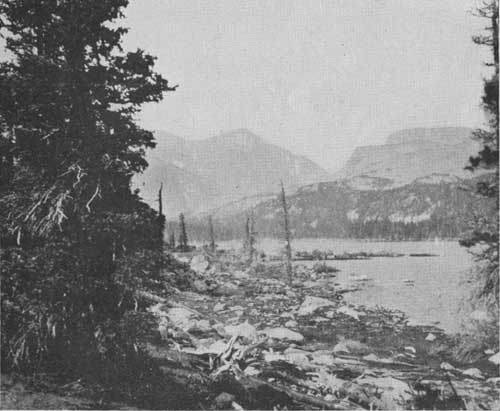
| FIG. 18.—Clouds Peak and Clouds Peak Lake, Bighorn National Forest (F-50500-A) |
Two automobile roads cross the Bighorn Forest east and west, the one in the north extending from Sheridan to Lovell, and the one in the south from Buffalo to Tensleep. Most of the auto camping is concentrated along these two roads, partly because other portions of the forest are not accessible.
Recreationists find in the national forests a maximum of freedom—as much as is compatible with adequate fire protection and sanitation. Although incidental to the original purposes for which the national forests were established, such use of the forests is important and is given due consideration in coordinating the utilization of the various forest resources.
For those who require a greater degree of permanence and "civilization" in their outings than camping affords, summer-home sites have been surveyed on the Bighorn at appropriate places along these roads and in a few other localities accessible to automobiles. These sites may be obtained under permit at nominal rentals.
"Dude" ranches in the Bighorn also attract many visitors. People of widely differing experience gain the acquaintance of the Bighorn wilderness, forest lands, hidden lakes, and inspiring peaks under the genteely primitive auspices of these institutions. They offer all of the delights of genuine roughing it without any of the accompanying inconveniences or serious hazards. Many picturesque trails provide ample opportunity for excursions with horse and pack outfits from the home ranches up into the real wildernesses. A particularly beautiful trip is that up Solitude Trail, in the course of which many lakes and other interesting places are encountered. This trail winds through about 52 miles of the Clouds Peak region and is well provided with signs and other improvements of assistance to travelers.
| <<< Previous | <<< Contents>>> | Next >>> |
|
circ-82/sec4.htm Last Updated: 29-Feb-2012 |