|
Routt National Forest |
|
In Ways of Greatest Service
THE ROUTT NATIONAL FOREST, like other national forests of the United States, was established and is maintained for the purposes of preserving an adequate vegetative cover for regulation of stream flow and prevention of erosion, of growing timber to satisfy human needs, and of making the timber, water, and other forest resources available to the people of this country in ways of greatest service.
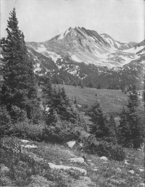
Located in northwestern Colorado on both slopes of the Continental Divide, this forest includes three distinctive chains of mountains. They are: The Park Range, which forms the Continental Divide; the Gore Range, a southern spur from the Divide branching off near Rabbit Ears Mountain; and the Elkhead Mountains, another spur extending westward from the Divide. In this vast area are some of the most beautiful and rugged peaks of the Rocky Mountain region.
When first established by proclamation of President Theodore Roosevelt, on June 12, 1905, the forest was called Park Range Forest Reserve. On July 1, 1908, the original name was changed to Routt, in honor of Col. John N. Routt, who was the last territorial and first elective governor of Colorado. Several additions and other changes have been made since the original proclamation. The net area of Government-owned land in the forest, as of June 30, 1940, was 984,226 acres.
|
| LOOKING TOWARD BIG AGNES MOUNTAIN F—364903 |
WHEN THE LAND WAS NEW
Early fur traders entered the present limits of the Routt many times, but the most interesting early explorations of that vast wilderness were those of Capt. John C. Fremont, in 1844, and Sir George Gore, in 1855.
Fremont, on his return from the Oregon-California expedition, traveled through the northwest corner of the State, crossing the present area of the Routt National Forest and the Continental Divide, to the North Platte River. There he decided to search for the headwaters of the Arkansas River, rather than return via Fort Laramie, and turned southward across Muddy Pass, to Middle Park. He crossed the Grand River, now the Colorado, and followed the valley of the Blue River to the pass which now bears his name, thence eastward by way of Pueblo.
Gore, a wealthy Irishman, for whom the Gore Range was named, went into North and Middle Parks with a large hunting outfit, guided by a noted scout, Jim Bridger. This party claimed to be the first white men to visit the springs at Steamboat, but this report is substantiated only by the lack of such a report by other explorers.

|
| BIG CREEK LAKE AND RED ELEPHANT MOUNTAIN F—364901 |
HOW TO REACH THE FOREST
BY MOTOR.—Modern highways provide safe, comfortable access to the Routt Forest from the North, South, East, and West. From the East one may follow U S 40 over Rabbit Ears Pass, take the Gore highway State Highway 84, over the Gore Range from Kremmling, or enter North Park via the Cameron Pass route, State Highway 14. Roads leading northward from Walden and Craig are connecting links with the Lincoln Highway, U S 30, in southern Wyoming. Motorists may reach the forest from the South by taking State Highway 11, a spur off U S 24, at Wolcott, then following State Highway 131 down the Yampa River from State Bridge to Steamboat Springs. U S 40 provides the main entrance for visitors from the West. Powerful snow plows keep this road open over Rabbit Ears and Muddy Passes throughout the winter.
BY RAIL.—A 7-hour daytime trip over the Denver & Salt Lake Railroad from Denver, via the 6.4-mile Moffat Tunnel, takes one to Yampa, Steamboat Springs, Hayden, or Craig, through some of the most beautiful mountain scenery in the Rockies. The construction of this railroad across the Continental Divide and onward to Craig, from 1905 to 1913, was a gigantic undertaking, and timber for railroad ties and other uses from the national-forest areas it traversed contributed greatly to the sucess of the venture. The Moffat Tunnel, which later replaced the 23-mile section of railroad over the divide, is a monument to David H. Moffat, who opened up the way to the great coal, timber, and ranching resources of the northwest corner of the State, including the Routt and other national forests. The story of his resourcefulness and courage in overcoming the many obstacles encountered is one of the most thrilling sagas of the development of the West.
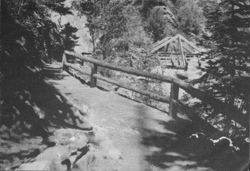
BY TRAIL.—The Routt maintains a good system of trails, by which it is possible to travel by saddle horse or on foot to almost any point of the more wild and rugged areas.
|
| A GOOD TRAIL INTO THE HIGH COUNTRY F—405391 |
| <<< Previous | <<< Contents>>> | Next >>> |
|
handbooks/routt/sec1.htm Last Updated: 19-Nov-2010 |