|
National Forests in the Southern Appalachians
|
|
Chattahoochee National Forest
LOCATION AND DESCRIPTION.—This forest lies entirely in Georgia and extends from the South Carolina line across the northern edge of the State. In the northwest corner of Georgia is located the Armuchee Purchase Unit, administered as part of the Chattahoochee National Forest but not included in the scope of this booklet. The forest supervisor of the Chattahoochee has his headquarters at Gainesville. There are three ranger districts, with headquarters at Clayton, Suches, and Blue Ridge.
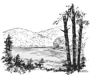
The Blue Ridge passes through almost the entire length of this forest, rising abruptly from the Piedmont foothills to a rounded crestline and then sloping gently to the north. Many of the streams south of the Blue Ridge are deeply intrenched, Tallulah Gorge being the most notable example. The beauty of the forest is further enhanced by a number of lakes, among them the chain consisting of Lakes Yonah, Tugaloo, Rabun, Nacoochee, and Burton, southwest of Clayton, and Lake Toccoa near Blue Ridge. There are also many waterfalls, including Goslin Falls near Lake Rabun, Bridge Creek Falls, Amaruby Falls, and Amicalola Falls which is the highest in the State.
Many landmarks and legends were left behind by the Cherokees. Among them may be mentioned Blood and Slaughter Mountains, scene of a fierce Indian battle; Stone Pile Gap, reputed burial place of Princess Tralyta; Yonah Mountain with its lovers' leap; and Warwoman Creek.
Most of the land included in this forest is well wooded. Generally there is excellent young growth and the entire forest is approaching a stage of high productivity. On a 4,000-acre body of timber near Blairsville, known as the Toccoa Experimental Forest, improved methods of forest protection and timber management are tested. The Chattahoochee National Forest has a gross area of 1,270,000 acres, of which 580,000 acres have been purchased by the Government or are in process of acquisition. Upon Government land there is a stand of approximately 960 million board feet of merchantable timber, in addition to 400 million board feet of blight-killed or damaged chestnut. Growth is sufficient to permit an annual cut of more than 17 million board feet.
|
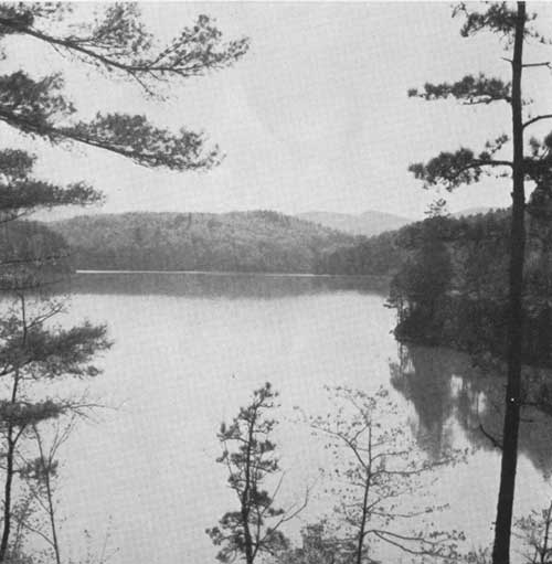
| Lake Rabun, in the Chattahoochee National Forest: One of a chain of power lakes in north Georgia, most of whose water comes from the nafional forests. F—386649 |
HUNTING AND FISHING.—Hunting for turkey, quail, and squirrels is good on this forest. The stock of deer has been depleted, but is being built up so that in the future excellent deer hunting will be available. The forest is also good fishing country. Many of the streams are well stocked with rainbow and brook trout; bass and bream are plentiful in the lakes; muskellunge are found in Lake Toccoa.
Within the Chattahoochee National Forest four cooperative wildlife management areas have been established. The streams in these areas have been stocked with trout and are opened in rotation for brief periods. Hunting will be permitted when the stock of game has been built up to a point where an annual harvest can be removed. These four areas are:
Cohutta Area.—Includes 40,768 acres at the headwaters of Conasauga and Jacks Rivers. Accessible by Forest Service roads from Blue Ridge and Eton.
Blue Ridge Area.—This includes the 24,500-acre Noontootly National Game Refuge on Noontootly and Rock Creeks on the north side of the Blue Ridge and an additional 16,635 acres south of the ridge. It is reached by Forest Service roads from Dablonega on the south and Blue Ridge on the north. On Rock Creek, within the game refuge, is a trout rearing station with complete modern equipment, where 80,000 young trout are raised annually to stock the mountain streams.
|
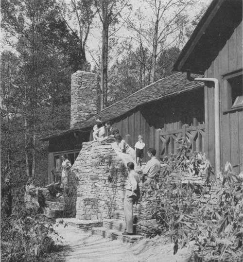
| Bathhouse constructed by the C. C. C. at the Lake Winfield Scott Recreation Area. F—386661 |
Chattahoochee-Chestatee Area.—This area of about 56,000 acres is bounded on the north by the Blue Ridge and lies on the headwaters of the Chattahoochee and Chestatee Rivers and their tributaries. It is reached by U S 19 from Dah Iomega and Blairsville and by Georgia Route 75 from Cleveland and Hiwassee.
Lake Barton Area.—This l5,000-acre area lies on the southeast slope of the Blue Ridge on streams draining into Lake Burton. It is accessible by Forest Service roads from Clarkesville on the south and Lakemont on the east, and from U S 76 on the north.
RECREATION.—This forest is within 2 hours drive from Atlanta and other Georgia cities and receives heavy recreational use. Towns within the forest take care of thousands of summer visitors. The Forest Service maintains the following recreation areas:
Warwoman Dell.—Three miles east of Clayton. Picnicking, hiking, and a nature trail.
Rabun Beach.—On the shore of Lake Rabun 3 miles west of Lakemont. Bathing, picnicking, tent and trailer camping.
Tray Mountain.—A roadside picnic area on the Blue Ridge, reached by Forest Service road from Helen.
Chestatee Knoll.—A roadside picnic area on U S 19 between Turners Bridge and Neals Gap.
Lake Winfield Scott.—A 250-acre forested area surrounding a 20-acre lake, more than 2,900 feet above the sea. Reached by Forest Service road from Suches or via Wolf Pen Gap from U S 19. Bathing, picnicking, tent and trailer camping, sites for summer cottages.
Enota Glade.—A small picnic area at the foot of Brasstown Bald.
Woodys Gap.—Picnic facilities where a Forest Service road crosses the Blue Ridge.
Pigeon Creek.—A wayside picnic area southeast of Blue Ridge.
Jacks River.—A picnic area at the foot of a waterfall northwest of Blue Ridge.
Lake Conasauga.—An 18-acre lake more than 3,300 feet above the sea, the highest body of water in Georgia. When development is complete there will be facilities for bathing, picnicking, and camping.
Big Creek.—A roadside picnic area on Georgia Route 106 near Pine Mountain.
Bailey Creek.—A small roadside picnic area on the Scaly-Pine Mountain road northeast of Clayton.
Panther Creek.—On U S 23, 1 mile east mf Turnerville. Picnicking.
Fern Springs.——On Georgia Route 13, 4 miles northeast of Cornelia. Picnicking, play area, wading pool.
Cool Spring.—Near Black Mountain tower. Picnicking and hiking.
Chenocetah Mountain.—One and one-half miles from Cornelia. Picnicking.
Camp Wahsega.—An organization camp on a Forest Service road northwest of Dablonega.
Vogel State Park.—This park is located within the forest but is owned and operated by the State of Georgia. On U S 19. An inn at Neals Gap; picnic areas, bathing and rental cabins at Lake Tralyta.
ROADS AND TRAILS.—Many scenic highways and forest roads traverse the Chattahoochee National Forest. Among them are:
U S 23 to Tallulah Gorge and Lake Rabun.
U S 19, crossing the Blue Ridge at Neals Gap. Excellent views of gorge of Chestatee River.
Georgia Route 75, crossing the Blue Ridge at Unicoi Gap.
U S 76, traversing the forest from east to west, crossing the Blue Ridge and passing Lakes Burton and Toccoa.
The Scaly-Pine Mountain Road from Clayton to Highlands, N. C. Views of Rabun Bald and Blue Valley.
The Forest Service road leading west from Lakemont along the shores of Lakes Rabun, Nacoochee, and Burton.
The Forest Service road over Tray Mountain.
The Forest Service road, which starts at Stone Pile Gap on U S 19, crosses the Blue Ridge at Woodys Gap, and leads past the Suches Ranger Station, Lake Winfield Scott, and Wolf Pen Gap, rejoining U S 19 at Vogel State Park.
The Forest Service road from U S 19 near Dahlonega, reaching the top of the Blue Ridge at Coopers Gap and following the Ridge west to Hightower Gap, thence north down Rock Creek through the game refuge.
The Forest Service road along Potato Patch Mountain, west of Blue Ridge, and the Holly Creek Road with which it connects on the south.
The Appalachian Trail follows the crest of the Blue Ridge for nearly 90 miles through the Chattahoochee National Forest and affords many scenic views.
|
| <<< Previous | <<< Contents>>> | Next >>> |
|
handbooks/southern_appalachians/sec8.htm Last Updated: 19-Nov-2010 |