|
National Forests in the Southern Appalachians
|
|
Nantahala National Forest
LOCATION AND DESCRIPTION.—This forest is also located in North Carolina. The forest supervisor headquarters are at Franklin while the district rangers in charge of the three ranger districts are located at Franklin, Murphy, and Andrews. Although most of the area in this forest is not as rough and precipitous as some other portions of the southern Appalachians, its rounded mountains have a special beauty of their own and afford unexcelled views.
Scenic attractions include:
In the Franklin-Highlands section: Cullasaja Falls, Cullasaja Gorge, Dry Falls, Bridal Veil Falls, Lake Sequoyah, and Whiteside Mountain.
West of Franklin: Standing Indian Mountain with its fine views and displays of purple rhododendron, Wayah Bald noted for its views and for azaleas, Nantahala River, Queens Creek Falls, Winding Stair Road, and Nantahala Gorge.
In the Andrews-Robbinsville section: Lake Santeetlah and the Joyce Kilmer Memorial Forest. This Memorial Forest, dedicated to the author of the poem "Trees", includes 3,800 acres of exceptional virgin hardwood timber preserved in its primeval condition and should by all means be visited. It is accessible by Forest Service roads from Robbinsvilie.
Near Murphy: The Hiwassee Dam developed by the Tennessee Valley Authority.
|
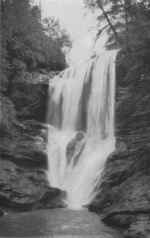
| Dry falls on the Cullasaja River in the Nantahala National Forest. F—198301 |
The gross area of the Nantahala National Forest is 1,349,000 acres, of which 325,930 acres have been acquired or are in process of being bought by the Government. The present stand of merchantable timber on Government land is about 600 million board-feet. On the Coweeta Experimental Forest south of Franklin important streamflow experiments are in progress.
HUNTING AND FISHING.—The Nantahala country was once a favorite Cherokee hunting ground. All kinds of game were abundant, and the mountain streams teemed with trout. In more recent years, however, the supply of game and fish has become depleted. No finer potential trout streams can be found than the Nantahala River and its tributaries and the streams that flow east from the high Unicoi Range; food and shelter for deer and other game are also available. With protection and judicious restocking, excellent hunting and fishing will result.
There are three cooperative wildlife management areas on the Nantahala National Forest: The 15,000-acre Fires Creek area north of Hayesville, the 9,000 acre Wayah Bald Game Refuge west of Franklin, and the 33,000-acre Standing Indian Area at the head of the Nantahala River. Trout fishing during certain limited seasons and under special regulations is permitted on these areas, and opportunities for hunting will be available when the depleted stock of game has been replenished.
|
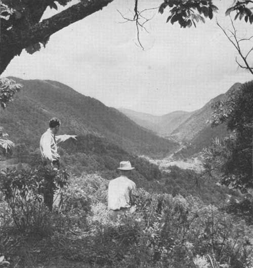
| The Nantahala Gorge: The "Place of the noonday sun" on U S 19. F—386657 |
At Arrowood Glade, 7 miles west of Franklin, rearing pools have been developed with an annual capacity of 60,000 young trout which attain in 6 months a length of 7 inches and are then planted in the forest streams.
RECREATION.—The portion of western North Carolina in which the Nantahala National Forest is located has long been popular with summer visitors. The section's attractions have been greatly enhanced by scenic roads and trails, picnic and sports areas, and other facilities for recreation constructed by the Forest Service.
Improved recreation areas in this forest include:
Arrowood Glade.—Seven miles west of Franklin by U S 64 and the Franklin-Nantahala Forest Road. Bathing, picnicking, and an arboretum.
Wayah Crest.—Six miles west of Arrowood Glade at Wayah Gap in the Nantahala Range. Overnight lean-to and picnic facilities.
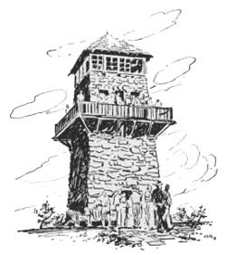
Wayah Bald.—The John B. Byrne Memorial Tower affords views into four States. Azalea blossoming season June and early July.
Deep Gap.—Seven miles by forest road south of U S 64 near Rainbow Springs. Picnicking and camping 4,500 feet above sea level. From Deep Gap the Appalachian Trail leads to the top of Standing Indian Mountain.
Gorge Dell.—A small picnic area on U S 19 in the Nantahala Gorge.
Vanhook Glade.—On U S 64 in the Cullasaja Gorge, 15 miles from Franklin. Trailer and tent camp sites.
Cliffside Lake.—On forest road 2 miles north of Vanhook Glade. Picnicking, bathing in 6-acre lake.
Ammons Campground.—A picnic area 3 miles southeast of Highlands.
ROADS AND TRAILS.—The Nantahala National Forest is well served by a network of highways and forest roads, many of which are of high scenic quality. Among these may be listed:
U S 64 from Franklin via the Cullasaja Gorge, Highlands, and continuing east to Rosman. The same route west from Franklin, crossing the Nantahala Mountains to Hayesville and Murphy.
U S 19 from Murphy via Andrews, Topton, the Nantahala Gorge, and Balsam Gap to Asheville.
U S 129 from Topton via Robbinsville and Lake Santeetlah to Tapoca.
U S 23 from Franklin across the Cowee Mountains to U S 19 at Dillsboro.
N. C. Route 106 down the Tuckasegee River.
N. C. Route 286 from Franklin down the Little Tennessee River.
The Forest Service road from U S 64,4 miles west of Franklin across the Nantahala Mountains and via the Winding Stair Road to US 19, in the Nantahala Gorge.
The Forest Service road down the Nantahala River from U S 64 at Rainbow Springs.
The Forest Service road across the Tusquitee Mountains via Tuni Gap.
The Forest Service road from Dillard, Ga., to Highlands.
The Forest Service road from Andrews across the Snowbird Mountains to Robbinsville and continuing via the western shores of Lake Santeetlah to a junction with U S 129.
The Appalachian Trail which enters the forest near the Tennessee line and traverses the entire length of the Nantahala Mountains is outstandingly scenic. Another interesting trail leads through the Joyce Kilmer Memorial Forest to Hangover Mountain and encircles the watershed of Little Santeetlah Creek via Stratton Bald.
| <<< Previous | <<< Contents>>> | Next >>> |
|
handbooks/southern_appalachians/sec7.htm Last Updated: 19-Nov-2010 |