|
National Forests in the Southern Appalachians
|
|
Pisgah National Forest
LOCATION AND DESCRIPTION.—This forest lies entirely in North Carolina, with the forest supervisor headquarters at Asheville. It is divided into four ranger districts.
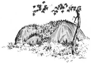
The Pisgah ranger district lies southwest of Asheville, with headquarters at Pisgah Forest near Breyard. It is bordered on the west by the high and rugged Tennessee Ridge and Balsam Mountains, many of whose peaks are over 6,000 feet high. Trending northeast through the ranger district is Pisgah Ledge, whose most prominent peak is Mount Pisgah, a notable landmark visible for miles in every direction. The mountain streams in this section are exceptionally clear and pure and are broken by many waterfalls. Other features of interest are such rounded granite domes as Lookingglass Rock, Cedar Rock, and John Rock, the great expanses of laurel and azalea, known as the Pink Beds, and the Bent Creek Experimental Forest.
The French Broad ranger district, with headquarters at Hot Springs, adjoins the Great Smoky Mountains National Park on the west. It is characterized by narrow valleys and steep wooded slopes running up to rounded plateaus.
East of Asheville, with ranger headquarters at Marion, is the Mount Mitchell ranger district. This section is distinctly rugged in character, with its dominating peak Mount Mitchell, elevation 6,684 feet, the highest point of land east of the Mississippi River. Near Mount Mitchell may still be found areas of virgin red spruce, a part of which has been permanently preserved from lumbering under the designation of the Black Mountain Natural Area. Other points of interest include Craggy Gardens, Toms Creek and Crabtree Falls, and the Mount Mitchell Game Exhibition Farm.
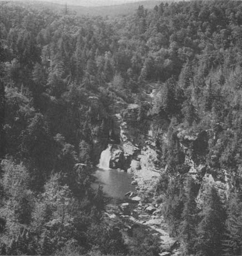
The Grandfather ranger district, with headquarters at Lenoir, occupies a wild, ravine-cut country south of Grandfather Mountain, the highest peak in the Blue Ridge. Its outstanding feature is famous Linville Gorge with Linville Falls at its head.
The gross area of the Pisgah National Forest is 1,178,000 acres, of which 454,560 acres have been acquired by the Government or approved for purchase. The present stand of merchantable timber on Government land is about 500 million board-feet.
HUNTING AND FISHING.—This forest affords some of the best hunting and fishing in eastern United States.
|
| Linville Falls at the head of Linville Gorge in the Pisgah National Forest. F—51017 |
On the Pisgah ranger district is located the 10,000-acre Pisgah National Game Preserve, where regulated trout fishing and deer, bear, and squirrel hunting are available. This preserve has been under wildlife management since 1916 and has a highly concentrated stocking of deer. Young fawns found in the thickets by trained searchers in late spring are raised at the unique fawn farm near the Pink Beds for distribution to other regions where the stock of deer has been depleted, and surplus adult deer are humanely trapped and shipped to other forests to be released. At the head of Davidson River there is a trout rearing station, from which 5- to 8-inch trout are transported in large quantities to restock mountain streams throughout the forest.
Also on the Pisgah ranger district, in the high cool spruce country at the head of Pigeon River, is the Sherwood Wildlife Management Area of 31,000 acres, managed in cooperation with the State of North Carolina. Here is some of the best brook trout fishing in the southern mountains, as well as grouse and bear hunting.
At the head of South Toe River in the Mount Mitchell ranger district is the cooperatively managed Mount Mitchell Wildlife Management Area of 25,000 acres, where there are excellent fishing for brook and rainbow trout, and grouse, squirrel, and bear hunting. Deer and turkey hunting will be permitted as soon as the stock of these species of game warrants it.
In the Grandfather ranger district is the Boone Wildlife Management Area of 40,000 acres, including some of Daniel Boone's old hunting grounds. Fishing for brook and rainbow trout is at present good and will improve as the streams become more fully stocked. Grouse and squirrel abound, bear are becoming increasingly common, and the stock of deer and turkey is increasing.
RECREATION.—The Pisgah National Forest, renowned for its scenery and easily accessible to such vacation centers as Asheville and surrounding towns, attracts increasing multitudes of visitors each year. Recreation areas developed by the Forest Service include:
North Mills River.—Five miles up North Mills River from N. C. Route 191. Picnicking, bathing, tent and trailer camping areas, council ring, children's playgrounds.
Stony Fork.—On the Pisgah Motor Road 18 miles from Asheville. Camping and picnicking facilities.
Bent Creek.—On Bent Creek 3 miles from N. C. Route 191. Camping and picnicking.
Frying Pan Gap.—A mile above the sea on top of Pisgah Ledge, 27 miles from Asheville. Camping and picnicking.
Pink Beds.—A picnic area on N. C. Route 284.
White Pines.—Near N. C. Route 284, 3 miles from forest entrance. Picnic and camping facilities.
Davidson River.—Beside Davidson River near N. C. Route 284. Picnicking and swimming.
Carolina Hemlocks.—On South Toe River 7 miles from Micaville via N. C. Route 104. Picnicking, swimming, council ring, facilities for tent and trailer camping.
Old Fort.—Beside U S 70, 2 miles west of Old Fort. Picnicking and hiking.
Craggy Gardens.—At end of Craggy Gardens Road 11 miles from Barnardsville. Picnic facilities. Scenic trail leads to spectacular mile-high rhododendron gardens. Blossoming season mid-June.
Big Ivy.—On Corner Rock Road 5 miles from Barnardsville. Affords picnicking, camping, and swimming.
Silvermine.—Located just off U S 25 across French Broad River from Hot Springs. Picnicking, swimming, hiking, and limited camping facilities.
Table Rock.—At end of Table Rock Road, 20 miles from Morganton via N. C. Route 181. Picnicking and hiking, exceptional scenery.
South Toe Organization Camp.—On South Toe River Road 3 miles from N. C. Route 104 at Busick. Camping facilities for organizations.
The following resorts operate under permit on Government land:
Pisgah National Forest Inn.—On Pisgah Ledge beside Pisgah Motor Road, 25 miles from Asheville. Lodging and meals.
|
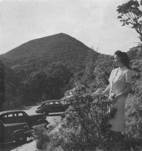
| Mount Pisgah, elevation 5,749 feet, from the Pisgah Motor Road, from which a trail leads to the summit. F—386653 |
Pisgah Parking Area.—On Pisgah Ledge, 24 miles from Asheville via Pisgah Motor Road. Trail to top of Mount Pisgah. Meals, soft drinks, and novelties.
Point Lookout.—On U S 70, 15 miles east of Asheville. Lodging, meals, and novelties.
Camp Alice.—Near the crest of Mount Mitchell. Meals and lodging.
ROADS AND TRAILS.—In addition to over 100 miles of State and National highways which cross the Pisgah National Forest, there are some 300 miles of forest roads, most of which are open to the public nearly all year. A few of the many scenic routes and loops through the forest are:
From Asheville.—Via U S 19—23, N. C. Route 191, N. C. Route 280, N. C. Route 284, Pisgah Motor Road, and U S 19—23, including Davidson River, Lookingglass Falls, Fawn Farm, Pisgah Inn, and Mount Pisgah. Distance 85 miles.
From Asheville.—Via U S 19, U S 19—E, N. C. Route 104, and U S 70, including Burnsville, Carolina Hemlocks campground, Buck Creek Gap, and Lake Tahoma. This trip encircles the Black Mountain Range and affords fine views of Mount Mitchell. Distance 100 miles.
From Asheville.—Via US 19, U S 19—E, N. C. Route 194, US 221, US 321, N. C. Route 18, and U S 70, including Burnsville, Linville, Grandfather Mountain Blowing Rock, Lenoir, Morganton, and Marion. Distance 230 miles.
From Marion.—Via U S 70, Curtis Creek Road, Neals Gap Road, N. C. Route 104, U S 19—E, N. C. Route 26, U S 221, and U S 70, including Big Laurel Gap, Mount Mitchell Game Exhibition Farm, Carolina Hemlocks campground, Spruce Pine, and Little Switzerland. Distance 70 miles.
From Prevard.—Via U S 64, North Fork French Broad River Road, Gloster Road, Davidson River Road, and N. C. Route 284, including Rosman, Balsam Grove, fish rearing station, Lookingglass Rock, and John Rock. Distance 45 miles.
From Lenoir.—Via N. C. Route 18, U S 221, and U S 321, including Morganton, Linville, Grandfather Mountain, and Blowing Rock, most of the route affording majestic views of the Grandfather district. Distance 75 miles.
There are some 550 miles of graded trails in the forest. In addition to the Appalachian Trail, following is a partial list of trails to scenic and interesting points:
Craggy Mountain Trail from Craggy Gardens to Little Cane River Gap via Balsam Gap. 18 miles.
Higgins Bald Trail from Busick to Mount Mitchell. Distance 5 miles.
Camprock Trail from Loftis Cabin to Mount Mitchell. Distance S miles.
Harper Creek Trail from Kawana to Mortimer-Piedmont Road, via Harper Creek Falls. Distance 4 miles.
Mount Pisgah Trail from Pisgah parking area to top of Mount Pisgah. Distance 1-1/4 miles.
Pisgah Ridge Trail from Wagon Road Gap to Tennessee Bald. Distance 18 miles.
Bent Creek Horse Trails. A network of 100 miles of trails and old woods roads, in the Bent Creek section, for equestrian use.
Blowing Rock-Thunder Hole Horse Trail. Distance 7 miles.
| <<< Previous | <<< Contents>>> | Next >>> |
|
handbooks/southern_appalachians/sec6.htm Last Updated: 19-Nov-2010 |