|
SEARCH FOR SOLITUDE: Our Wilderness Heritage |
|
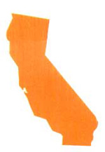
CALIFORNIA
This is a land of contrasts, with the highest and the lowest places in the contiguous United States within sight of each other. Mount Whitney rises to 14,495 feet and a few miles away is Death Valley, 280 feet below sea level. Within this zone can be found all but one—the tropical—of the world's climatic zones.
Southern California is a vast desert panorama framed by rugged, sparsely vegetated, stark mountains. Desert flowers bloom in abundance after rare spring rains, softening the landscape with riotous color.
High on the western slopes of the Sierra, the forests form a buffer zone for the valley floor. Here, canyons that once produced millions in gold are now valuable for recreation. The Sierra's eastern slopes, among the most precipitous in the country, plunge into beautiful and fertile valleys, where hundreds of trout streams are replenished by eternal snow on the high elevations.
|
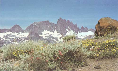
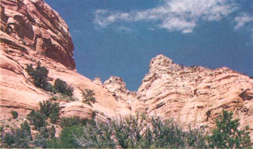
| The Minarets in the Minarets Wilderness, Inyo and Sierra National Forests, California F-519729 |
| Wilderness | Date Created |
National Forest |
Acreage | Description |
| CALIFORNIA | ||||
| Caribou | 1931 | Lassen | 19,080 |
This is a gentle, rolling, forested plateau. It contains many forest-fringed lakes in volcanic or glacial depressions which are in striking contrast to barren rocky areas with numerous cinder cones and small mountain peaks. The lake areas offer attractive camping spots, and many of the larger ones are stocked with fish. There are no major peaks. However, Caribou Peaks, for which the area is named, Black Cinder Rock, and Red Cinder Cone are prominent points of interest along with many smaller cinder cones. The forest cover is mostly Jeffrey and lodgepole pine with white and red fir, and western white pine interspersed with hemlock. |
| Cucamonga | 1931 | San Bernardino | 9,022 |
This is a rough and rugged land of sharp peaks and steep mountainsides with elevations ranging from 5,000 to 9,000 feet. The land contains ponderosa, Jeffrey, lodgepole, and sugar pine. There is an occasional meadow or "cienega." Water is scarce in the highest parts. The Middle and North Forks of Lytle Creek have water yearlong. The Middle Fork is the only fishing stream. It can be reached from Lyde Creek settlement. The season is limited as fire closures restrict all public use along this stream inside and outside of the Wilderness boundary after about June 20. The Cucamonga Wilderness is one of the few places in southern California containing mountain or bighorn sheep. Scattered small bands live on the mountain range. Telegraph Peak on the western perimeter towers 9,000 feet, with Cucamonga Peak a close second at 8,859 feet. Big Horn (8,441 ft.) and Timber Mountain (8,303 ft.) complete the western boundary. |
| Desolation | 1931 | Eldorado | 63,469 |
This is fishermen's country. An area of small streams and about 130 lakes, with some as large as 900 acres. It is one of the most northerly sections of the glaciated High Sierra-type scenic lands. Elevations range from 6,500 to 10,000 feet. Pyramid Peak dominates a group of four high summits on the southern boundary. Timber and flora are alpine in character and exceptionally beautiful. A foot and horse trail runs the length of the area starting at Echo Lake and ending at Emerald Bay, a distance of about 20 miles. There are side trails leading to small lakes. |
| Dome Land | 1963 | Sequoia | 62,121 |
A picturesque land of granite domes, 70 miles east of Bakersfield on the southern end of the Kern Plateau, between the South Fork and the mainstream of the Kern River. It is an open, semi-arid area with elevations from 3,000 to 9,000 feet; the days are warm, and the nights are cool. Vegetation on the lower slopes is light, consisting mostly of pinyon pine, some mixed conifer, sagebrush and rabbit brush. Erosion and weathering have left the area strewn with odd-shaped monolithic rock outcroppings, giving rise to the name "Dome Land." |
| Hoover | 1931 | Inyo, and Toiyabe | 42,779 |
This small and extremely rugged Wilderness is best suited to the hardy backpacker. The trails are too high and rugged for easy horse travel. It ranges in elevation from 8,000 to 13,000 feet. In one area, within a distance of 5 miles, there is a 5,000-foot change of elevation. The season is but 2 months long — July and August. Even then, the hiker and camper should be prepared for all kinds of weather including rain, summer blizzards, extreme cold, and heavy winds. Most of the area is alpine type with little timber. Numerous lakes are bordered by meadows and an occasional small stand of lodgepole pine or aspen which offer protected camping spots. The lakes and streams are stocked with rainbow, brook, and golden trout, and offer good fishing. The Hoover Wilderness lies west of Mono Lake and extends north of Tioga Pass, up the east slope of the Sierra Nevada to the main summit. Its west boundary is contiguous with Yosemite National Park. |
| John Muir | 1931 | Inyo, and Sierra | 503,258 |
Named for the famed naturalist, John Muir, California's largest Wilderness is considered by some to be the most inviting in America. It extends along the crest of the Sierra Nevada from Mammoth Lakes, southward along the eastern border of Kings Canyon National Park to the Mount Whitney region. Rugged grandeur characterizes this area. At the lower elevations there are gentle slopes along the streams and lakes. Included are the headwaters of the South and Middle Forks of the San Joaquin River as well as numerous smaller streams which drain into the Owens Valley. Thousands of lakes are scattered throughout the area. Lodgepole pine, red fir, and scattered alpine species cover the lower slopes where they border the Inyo and Sierra National Forests. Rugged snow-capped mountains form the major portion of the area, and there is a frost-free period from about July 15 to August 31 when the fishing is good. The streams and lakes are well-stocked with golden and eastern brook trout and rainbow. It is the summer range for an estimated 50,000 head of mule deer. A few bands of mountain sheep inhabit the southern portion near Mt. Whitney; they are protected by law. |
| Marble Mountain | 1931 | Klamath | 213,363 |
This is a mild and mellow country, without the harsh rock formations of most sub-alpine areas. It is almost entirely forested and easily traveled over shaded and gently rising trails. Glaciated pockets in the heads of streams along the main ridges form lakes hidden against the ridges, with adjacent meadows for ideal camping spots. Lakes are abundantly stocked with native trout in the upper reaches from August to October. The lower and larger portions of the streams support ocean runs of steelhead and salmon. It is relatively free of insects. Deer, bear, and other forms of wildlife are plentiful. Alpine flowers abound. Some species found here occur nowhere else in the world. Many fine stands of the rare Brewer's or weeping spruce contrast richly with the colorful meadow flowers. Hunting is difficult but well worth the effort. The Columbian black-tailed deer found here are among the finest and largest of this species in California. Bear inhabit the high ridges in the summer, migrating to the lower slopes to hibernate in the fall. The area is named for Marble Mountain. This marble cap, 700 to 1,000 feet thick, formed from the bodies of sea organisms deposited when the peneplain was the bottom of the ocean. This mass has been crystallized and raised into beautiful white marble which creates the visual impression of perpetual snow. |
| Minarets | 1931 | Inyo, and Sierra | 109,484 |
This area includes the spectacular high country east of the Sierra crest. It is rugged with elevations from 7,000 to 14,000 feet. Mt. Dana, the jewel of its northern corner (13,053 ft.), towers above its sister peaks, Mt. Gibbs (12,764 ft.); Mt. Lewis (12,296 ft.), and half a dozen more—all over 12,000 feet high. About midway along the divide, Ritter Range is topped by Ritter and Banner Mountains, and the Minarets for which the area is named. Several lakes are in the central portion including Waugh, Gem, Thousand Islands, Garnet, and many smaller ones. All of them, with their tributaries, offer fine fishing. The area affords unexcelled opportunities for the experienced mountain climber. The John Muir Trail crosses the Wilderness from the Devil's Post Pile National Monument, just off its southeastern boundary, to Donohue Pass where it goes down Lyell Creek Pass to Yosemite National Park. Annual temperatures range from 15 degrees below zero to 85 degrees above. The closest road access is through Mammoth Lakes to Reds Meadow. |
| Mokelumne | 1963 | Eldorado, and Stanislaus | 50,400 |
Barren Mokelumne Peak dominates the Wilderness. From its rocky prominences, the entire surroundings are revealed as lands of massive granite formations, carved and polished by the wind and water. The Mokelumne River flows on a southwesterly course. Its deep canyon bisects the Wilderness at an elevation of some 4,000 feet. Along the eastern boundary lies a vast granite mass more than 6 miles square which reaches a height of nearly 10,000 feet. Here the twisted and gnarled junipers stand as mute evidence of the forces of rain, wind, and snow. Within the shallow valleys north of Mokelumne Peak there are many small, scenic lakes. Along the shores are beautiful primitive camping spots. There are other good camping locations beside the Mokelumne River. Wildlife is abundant. California mule deer and Columbian black-tailed deer graze the alpine meadows. A few mountain lions inhabit the higher reaches, and an occasional black bear may be seen. There are several fine fishing spots along the main river course. Timber consists of scattered stands of fir, pine, cedar, and hemlock. Many colorful native shrubs are in the area, and during much of the year there is an almost endless display of native wildflowers. |
| San Gabriel | 1932 | Angeles | 36,137 |
Some of the most scenic country in southern California has been preserved in this Wilderness. It is rough, rugged country with elevations from 1,600 to 8,200 feet. Much of the region is covered with chaparral, but above 5,000 feet there is mixed pine and fir timber along the ridgetops. Part of the area is accessible by trail. Both backpackers and horsemen will find these trails rugged and challenging. One trail extends 4 miles into Upper Devils Canyon; another winds for 7 miles to Twin Peaks Saddle; and one other extends 2 miles up Lower Bear Canyon. The interior offers opportunity for a week or more of exploration over rough and brush-covered terrain. Fishing is good. |
| San Gorgonio | 1931 | San Bernardino | 34,644 |
This Wilderness covers the summit region of the San Gorgonio Mountain Range, the highest range in southern California. It is well-timbered on its northern slopes with lodgepole, sugar, and Jeffrey pine and some unusually fine specimens of white fir and black oak. Outstanding attractions are the three peaks: San Gorgonio Peak (11,502 ft.), San Bernardino Peak (10,624 ft.) which is the initial point for the San Bernardino meridian, and East San Bernardino Peak (10,630 ft.) with their tremendous expanses of mountain and desert views. Small meadows and lakes offer contrast to wide reaches of bare rock. Only experienced hikers should stray from marked trails, as water is scarce and the going is rough. In the rugged country of the North Fork of Whitewater River, one could camp undisturbed for days. The South Fork trail from Barton Flats is popular throughout the summer. Fishing is fair in most of the lakes. Deer hunting, too, is fair. There are a few bighorn sheep on the east side, protected by law. Botanists and biologists will find unusually good opportunities for study of flora and fauna, from desert to alpine. |
| San Jacinto | 1931 | San Bernardino | 20,564 |
This area lies high along the crest of the San Jacinto Mountains and contains some of the most spectacular mountain country in southern California. The San Jacinto State Park divides the area into two portions. The northern portion looks down on San Gorgonio Pass and covers all the Snow Creek drainage. This country is well watered, with good fishing below the falls on all main branches of Snow Creek. There are no trails and no public camps. The northern portion is the most spectacular of the two sections. It is one of those rare bits of wild country in which no evidence of previous habitation by man has been found. The views of the Mojave Desert, San Gorgonio Mountain, and the extreme contrasts from Arctic-Alpine life zones to the Sonoran zone, or desert, are among the most spectacular in California. |
| San Rafael | 1932 | Los Padres | 142,722 |
This area is located in the San Rafael and Sierra Madre Mountains north of Santa Barbara. Relatively low elevations (1,166 to 6,596 feet) make the area attractive in winter and spring (when most high mountains are covered with snow), but hot and unappealing during the summer and fall. Fire closures are usually in effect in the summer which prohibit entry into the area until fall rains lessen the fire danger. Forest fire is an ever-present threat. Along the highest ridges are forests of ponderosa, Jeffrey, sugar, Coulter, digger, and pinyon pine, with some bigcone Douglas-fir, white fir, and incense cedar. These forests contrast sharply with the brush-covered lands of the surrounding mountains. The area contains three major streams: the Sisquoc River, and the Manzana and Santa Cruz Creeks. Fishing is fair. A 1,200-acre sanctuary for the California condor is within the Wilderness. Entry is prohibited except by permission of the Forest Supervisor who may allow scientific research. Deer are plentiful, but fire danger usually prohibits entry during the deer hunting season. California mule and Columbia blacktailed deer share the range, most of which is closed to grazing of domestic livestock. |
| South Warner | 1931 | Modoc | 68,507 |
In the extreme northeastern corner of California lie the Warner Mountains, an isolated spur of the Cascade Range. Here is an area of alpine scenery, peaks, canyons, glacial lakes, and lush mountain meadows. Eagle Peak towers to 9,906 feet and dominates the area. Warren Peak (9,722 ft.), in the central portion, has on its northern flank Patterson Lake which nestles against the mountain at an elevation of 8,875 feet. Behind the lake, a massive backdrop of cliffs rises 800 feet to the top of the peak. Nearby Squaw Peak (8,650 ft.), almost at the northern boundary of the area, serves as a landmark. Summit Trail, traversing the backbone of the area, runs 27 miles from Patterson Meadow just off the southern border of the area to Porter Reservoir on the north. It is a favorite trail for those who like alpine scenery, since it follows the 9,000-foot contour for more than 15 miles along a ridge. It skirts the western flank of Eagle Peak, passes by Patterson Lake, and approaches the top of Squaw Peak. Numerous spur trails lead to gleaming glacial lakes and grassy meadows. Trout fishing in the streams is good most of the season. A portion of the area lies within a game reserve, but most of the area is open during deer hunting season, and mule deer are plentiful. |
| Thousand Lakes | 1931 | Lassen | 15,695 |
This is an area suited only to short trips. It received its name from the many lakes in the lava "pot holes" formed during ancient eruptions of an extinct volcano now known as Magee Peak. This 8,676-foot mountain is in the western portion of the area. Its top is now accessible by trail. Hall Butte, Tumble Buttes, and Freaner Peak are typical cinder cones. The main attraction is Thousand Lakes Valley, a 500-acre expanse of level ground in the northern portion. There are seven major lakes within the Wilderness. All are well-stocked with rainbow trout. Fishing is generally good throughout the season. Many of the smaller lakes however, are not capable of carrying trout through the winter. Hunting is not good because of a lack of forage. Some bear are found. Timber is mostly ponderosa pine, fir, and some sugar pine. |
| Ventana | 1931 | Los Padres | 95,152 |
This is a hiker's paradise. The major portion lies on the coastward side of the Santa Lucia Coast Range. At one point the area joins Pfeiffer-Big Sur State Park. The lower slopes are mostly chaparral covered, with woodland and timber along many miles of all-year streams. Ridge tops support good stands of ponderosa and Jeffrey pine, and the north slopes are covered with native oak and madrone. Old growth coast redwoods occur in Little Sur and Big Sur Canyons. The rare and beautiful bristlecone fir, sometimes called Santa Lucia fir, is also native to this area. Elevations vary from 1,200 feet on the little Sur River to 4,833 feet on the summit of Ventana Peak. Because of heavy use, and the exceptionally high fire hazard, about 25 camp sites have been established. These are necessary in the interest of fire safety. During the summer and fall fire seasons certain restrictions are in effect, and during extremely hazardous periods entry may be made by permit only. Registration stations are at the main points of entry. Bird life is abundant all summer long. Almost all of the streams are stocked with rainbow trout. Wild boar, deer, wild pigeon, and quail may be hunted in season. |
| Yolla-Bolly-Middle-Eel | 1931 | Mendocino, and Shasta-Trinity | 108,451 |
The North and South Yolla Bolly Mountains mark the north and south boundaries of this wild and rugged country on the headwaters of the Middle Fork of the Eel River. In the language of the Wintun Indians, who occupied the area before the white man came, this rolling musical name means "high snow-covered peaks." Annual precipitation is from 35 to 40 inches, and rains may be expected from October to May. Dense stands of pine and fir on ridges contrast with an extensive cover of chamise, manzanita, and mountain mahogany at lower elevations. These brush thickets offer excellent range for bear and black-tailed deer. There is excellent fishing in Cottonwood, Buck, and Balm-of-Gilead Creeks, all well stocked with trout. Horsefeed is ample during early summer, but scarce in the late fall. Not heavily-traveled, the area is full of scenic delights. On clear days, visitors can see both the Sacramento Valley and the Pacific Ocean from high points along the trails. |
| PRIMITIVE AREAS | ||||
| Agua Tibia | 1931 | Cleveland | 25,995 |
This is limited to wintertime use because high fire hazard requires that it be closed from July to October each year. Nevertheless, there is much of interest in the area during the open season for the visitor interested in the various flora and fauna. The flora ranges from desert plants at 1,500-foot elevation, to timber at the 5,600-foot level. Over half the area has not had large fires for more than 100 years, and it is rich in specimens of native plants. It is a natural laboratory for the study of plant growth and ecology of this mountainous section of southern California. Of particular interest is the chaparral belt which contains ceanothus, manzanita, and redshank which have reached what is considered optimum growth for these species. Plants 14 to 16 feet high are common, with manzanita reaching tree-like forms with base diameters of 8 to 10 inches. Tree species include white fir, incense cedar, bigcone Douglas-fir, and Coulter and Jeffrey pine. The oak-conifer type of timber provides habitat for many varieties of birds. These include a large population of band-tailed pigeons for which Palomar (pigeon roost) Mountain was named. Deer and small game animals are present, also mountain lions, bobcats, and coyotes. |
| Emigrant Basin | 1931 | Stanislaus | 97,020 |
This is an area of broad expanses of glaciated granite, towering lava-capped peaks, numerous alpine lakes and meadows, and deep granite-walled canyons. It is located at the headwaters of the Cherry and Stanislaus Rivers. Elevations vary from 6,000 feet in the lower reaches of the Cherry River to 11,575-foot Leavitt Peak at the crest of the Sierra Nevada. Timber consists of Jeffrey and white pine and some juniper in scattered stands, with an occasional grove of red fir and mountain hemlock or lodgepole pine in swampy stretches. It is bordered on the south by Yosemite National Park and is popular for pack trips out of the park. It is also popular for foot travel. The central portion is dotted with many lakes, some of which are unnamed. Huckleberry, Emigrant, and Long are the three largest lakes in the area. Fishing is good, particularly in the lakes. Deer, bear, and other wildlife are present. The best hunting is along the western ridge, west of Cherry River. |
| High Sierra | 1931 | Sequoia, and Sierra | 10,247 |
This extremely rough mountainous area is possibly the most wild in California. It includes Tehipite Valley, which approaches the scenic scale of Yosemite Valley. There is a great variety of vegetation and life zones between Tehipite Valley floor and the surrounding elevation. Monarch Divide is an area of rough terrain with few travel routes. |
| Salmon Trinity Alps | 1932 | Klamath, and Shasta-Trinity | 223,340 |
Although the Coast Range of California customarily is thought to be less spectacular than the Sierra Nevada, the Salmon-Trinity Divide along the crest of the Coast Range is as rough and wild an area as any found on the eastern side of the State. Mountain ridges and deep glacier-cut canyons comprise this vast area between the Trinity River and the Salmon River which includes parts of three National Forests. Granite peaks stand in a serrated, saw-tooth range. Thompson Peak (8,936 ft.) is the highest point. Timber is scattered, although good stands of Douglas-fir and pine are found along Coffee Creek and in the North Fork-New River section. The high peaks and ridges support typical timberline species such as foxtail pine, western white pine, and mountain hemlock. Several stands of the rare weeping, or Brewer's, spruce are found along Canyon Creek. Timber stands and brushfields give excellent shelter to deer in the area. Trout fishing is excellent in the many streams. Bear are plentiful, and occasionally a wildcat may be seen. |
THE NORTHWEST
OREGON AND WASHINGTON
The Pacific Ocean pounds against rocky cliffs, and inland jagged mountain peaks dominate the skyline. The giant trees of the coastal ranges are majestic and solemn, reminding one of vast cathedrals, out-of-doors. Here are lands of perpetual shadow formed by dense crowns of Douglas fir and Sitka spruce—growing more than 250 feet tall—and of the shorter hemlocks, cedars, and white firs.
On the floor of the forest only the most shade-enduring vegetation can live including forms that grow waist high. Such forests convey a feeling of everlasting life, with trees of all ages and sizes, from the overmature giants—5, 10, or 15 feet in diameter—to the current year's seedlings.
Slim, straight lodgepole pine forests cover millions of acres, often growing so densely together that passage is difficult. The ground cover is of sedges and grassses, with bright-blue lupine, brilliant orange tiger lily, and many other flowers.
Still further inland, the alpine forests of the Cascade mountain ranges are lighter, brighter, and more cheerful. At places, the trees are scattered and stunted from a lifetime of battling against the cold and wind. Strewn among them are alpine meadows, carpeted with fresh, green grass and many-colored flowers that have emerged after a hard winter of dormancy under snowdrifts unbelievably deep.
Swift-running mountain streams abound, originating from snowfields and glaciers at the higher altitudes. Mighty vistas of a series of snow-capped peaks in orderly array hold the viewer spellbound.
|
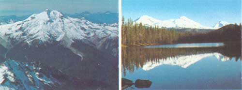
| 10,541 foot Glacier Peak in the Glacier Peak Wilderness, (left) Mt. Baker and Wenatchee National Forests, Washington. F-519730 Three Sisters Peaks in the Three Sisters Wilderness, Deschutes National Forest, Oregon. F-519731 |
| Wilderness | Date Created |
National Forest |
Acreage | Description |
| OREGON | ||||
| Diamond Peak | 1957 | Deschutes and Willamette | 35,440 |
The area was formed during the Pliocene or early Pleistocene period, when the entire land mass of the Cascades was undergoing volcanic activity and uplift. The mountain was formed as a large volcanic peak, and was later carved by great glaciers. Nearly the entire area is timbered with mixed stands of mountain hemlock, lodgepole and western white pine, and silver, noble, and other true firs. The Wilderness is the transient home of blacktailed and mule deer and elk. The mule deer migrate east to winter in the desert. Blacktailed deer and elk drop down the west slope. Bear and small mammals including marmot, snowshoe rabbit, squirrels, pine marten, fox, conies, and others inhabit the area yearlong. The raven, Clark's nutcracker, Oregon jay, and water ousel frequent the forest and streams year round. Bufflehead and golden-eye ducks occasionally nest near the lakes. Alpine flowers, including varieties of mimulus, lupine, pentstemon, Indian paint brush, and many others, are common along trails, lakeshores, streams, and in mountain meadows. The area is open for hunting and fishing during the regular seasons. There are eastern brook, golden, and rainbow trout in the streams. |
| Eagle Cap | 1930 | Wallowa-Whitman | 220,416 |
Eagle Cap Wilderness embraces the rugged grandeur of the Wallowa Mountains in Northeast Oregon. A mountain called Eagle Cap is the hub of many streams. Over 50 lakes lie at the foot of precipitous slopes or are hidden in basins on the upper mountain slopes. The higher mountains, particularly on their steeper slopes, are nearly devoid of timber or other vegetation and have vast expanses of granite rock. Geological formations, such as dikes and sills of different composition than the surrounding rock, are found on many peaks. Some of the main ridges are capped with limestone and marble. Where soil is present, whitebark pines cling to the ridges. Around the meadows and at the foot of the rugged slopes appear the alpine firs. In the heads of the canyons are Engelmann spruce, Douglas-fir, and white fir. An occasional ponderosa pine may be found near the lower confines of the area. The rough topography of the Wilderness is broken by numerous deep canyons, towered over by the highest peaks in eastern Oregon. The highest is Sacajawea, elevation 10,033 feet. Other high peaks are: Matterhorn, Pete's Point, Brown Mountain, Aneroid Mountain, and Eagle Cap. The dazzling white limestone of the Matterhorn contrasts with the reddish brown of adjoining rock formations. The Matterhorn, Sacajawea, and Eagle Cap are favorite climbs. No special experience or equipment is necessary, but caution should be used at all times. |
| Gearhart Mountain | 1943 | Fremont | 18,709 |
This whole area is interesting geologically, but of special interest are The Palisades, The Dome, and The Notch, which is part of Gearhart Mountain. The fourth area of special interest, particularly to fishermen, is Blue Lake, situated in the northcentral portion of the area. The water is always clear and cold. There is no streamflow in or out, indicating it is fed by subterranean springs. The Gearhart Mountain Wilderness is the only large area on the Fremont National Forest without roads. The area is an important summer and fall range for mule deer. There are also a few black bear, wildcats, coyotes, blue grouse, and cougar. |
| Kalmiopsis | 1946 | Siskiyou | 76,900 |
This is a harsh, rugged country with a character different from that of most Wildernesses. It is a land of rocky, brushy, low-elevation canyons and has unique beauty and fascination. Charred stumps and blackened tree trunks show that most of the Wilderness had been burned over. Some of the fires were probably set by lightning, but it appears that fur traders, trappers, prospectors, and early settlers were responsible for most. Botanically, the Kalmiopsis Wilderness and the territory surrounding it is one of the most interesting regions in the Northwest. Over 12 species of coniferous trees, 9 species of hardwood trees, 31 species of shrubs, and many species of herbaceous plants are found within its boundaries. Some of these plants are extremely rare. Kalmiopsis leachiana, a small shrub, somewhat resembling a miniature rhododendron, is a relic of the pre-ice age. It is the oldest member of the Heath family and the only plant in its genus. Visitors should be especially careful when traveling cross-country off the trails. Rattlesnakes are common. Travelers should always carry snakebite kits. Yellowjackets and hornets are numerous; persons allergic to the stings of these insects should take appropriate precautions. Poison oak is dense throughout the area. |
| Mountain Lakes | 1930 | Winema | 23,071 |
This area is bounded on all sides by high mountains. The highest point is Aspen Butte, with an elevation of 8,208 feet. Other high points include Mt. Harriman, 7,979 feet; Crater Mountain, 7,785 ft.; Greylock Mountain, 7,747 ft.; and Whiteface Peak, 7,706 ft. In the basin created within the rim of these high peaks are found numerous mountain-lakes noted for beautiful water and timbered shorelines. The lakes have been stocked with eastern brook and rainbow trout. During the summer months, the area is inhabited by black-tailed deer; in the fall, the lakes are used by wild ducks and geese. The area may be entered from all four sides. A loop trail system within the basin connects most of the more popular lakes. About 20 percent of the area contains smaller-sized alpine fir, white pine, and lodgepole pine. These trees are found above 7,000 feet. Meadow grass and several species of wildflowers are found along the lower creek drainages and basins. Two-thirds of the area is over 6,000 feet in elevation. Precipitation is largely in the form of snow, which reaches depths of 5 to 20 feet. Thundershowers occur quite frequently during July and August. Temperatures vary annually from minus 30 to plus 95 degrees. Frosts could occur during practically any month of the year. |
| Mount Hood | 1931 | Mount Hood | 14,160 |
At an elevation of 11,245 feet, Mt. Hood is probably the most frequently climbed snow capped mountain next to Fujiyama. Novices, with guides and rented equipment, can easily climb the mountain in the summer. Only the experienced should attempt to climb in winter as conditions can change very rapidly at high altitudes. Registers are placed at Cooper Spur Junction, Parkdale Ranger Station, and Timberline Lodge. Always register before climbing and check in upon returning. Weather is unpredictable and hikers should be prepared for whatever comes. The trails around Mt. Hood are usually opened to foot travel around July 15. They are not completely free from snow until mid-August. Throughout the rugged terrain are many alpine meadows carpeted with a myriad of mountain flowers. Lupine, avalanche lily, anemone, and inside-out-flowers are a few that bloom in the late summer months. Paradise and Eden Parks have probably the most spectacular displays of alpine flowers in the Wilderness. Located on the south side of Mt. Hood, Timberline Lodge is a popular entrance spot to the Wilderness for hikers, skiers, and mountain climbers. From Illumination Rock westward are innumerable routes. It is advisable to take an experienced guide along on cross-country trips in this area. Wildlife is not plentiful in the Wilderness, although deer, bear, bobcat, squirrels, grouse, and cougar roam the area and can be seen occasionally. There are no heavy fish-producing streams within the area. |
| Mount Jefferson | 1930 | Deschutes, Mount Hood, and Willamette | 99,600 |
Snowcapped Mount Jefferson and Three Fingered Jack are the main features of this Cascade summit area. Mount Jefferson, 10,497 feet, is the second highest peak in Oregon and has perpetual glaciers. Mount Jefferson long has been recognized as having wilderness values—organized wilderness-hiking clubs have made use of this area since 1900. The Mount Jefferson Wilderness is ideally suited for either a one-day hike or an extended camping trip. Both Mount Jefferson and Three Fingered Jack offer excellent opportunities for climbing, but hold risks for the novice without training or proper equipment. The area abounds with wild mountain flowers, unusual and interesting geological formations, and spectacular scenery. About half of the nearly 100 lakes in the area are good for fishing. |
| Mount Washington | 1957 | Deschutes, and Willamette | 46,655 |
A more rugged country than this is hard to and imagine. Mount Washington, at 7,802 feet, dominates the area. Its summit is topped by a jagged pinnacle rising hundreds of feet out of the mountain. Mount Washington is one of the most popular rock climbs in Oregon. It was first climbed August 19, 1923 by a group from Bend. The pinnacle of the summit has since challenged many parties over various routes. The climb should be undertaken only under the leadership of qualified climbers with proper equipment. The final ascent to the summit is through chimneys and sheer rock and requires exacting safety precautions. Hunting is good throughout the area and many of the 66 lakes within the area support fish. Most extensively used are the Patjens Lakes in the northwest portion. Blacktailed deer and a few elk feed up the west slope and drop over to the east slope in summertime. Mule deer, which winter in the Metolius Valley, ascend the east slope in the summer to the Cascade divide. Black bear and an occasional cougar also inhabit the area. And smaller mammals such as marmot, ground squirrels, pine squirrels, pine marten, conies, fox, coyote, snowshoe rabbits, and others may be found. Game birds are few; however, both ruffed and blue grouse may be found. Non-game birds frequent the area in summertime, and many species can be studied. |
| Strawberry Mountain | 1942 | Malheur | 33,003 |
Dominating the scenery around the head of the John Day River in Oregon is Strawberry Mountain, elevation 9,044 feet. Its five glacial lakes, thousands of acres of alpine and subalpine flora, and spectacular views are a welcome retreat for the sportsman, the photographer, or the nature lover. The Wilderness varies from 2.5 to 5 miles in width and is 18 miles long. It lies along a high east-west divide with Slide Mountain on the east, and craggy Canyon Mountain on the west. In between, such mountains as Pine Creek, Indian Creek Butte, Strawberry, and Rabbit Ears rise to heights between 7,090 and 9,044 feet. Each of the five lakes in the Strawberry Mountain Wilderness is open to year-round fishing. However, access is limited by the snowpack during all the seasons except summer. Good catches of rainbow trout or eastern brook can be made in any of the five lakes. Mud Lake is a beautiful, but fishless, shallow lake nearing the final ecological stage of filling-in with naturally deposited material. Big-game hunting for deer and elk is very popular in and near the Wilderness, and many excellent game animals are harvested each year. The southwestern corner is included in the Canyon Creek Archery Area. A few bear and many ruffed and blue grouse are also taken. The Wilderness also contains an interesting variety of forest vegetation, including ponderosa pine, western white pine, Douglas-fir, white fir, alpine fir, and other species. During July and August, the meadows and hillsides are ablaze with wildflowers and bushes. |
| Three Sisters | 1937 | Deschutes, and Willamette | 196,708 |
The snowcapped Three Sisters lie in a north-south line and form a part of the Cascade Divide. The Sisters are surrounded by associated peaks of similar volcanic origin. Mountains belonging to the same cluster include the Brother, Husband, Wife, and Broken Top. Forty miles of the Oregon Skyline Trail traverse the Wilderness from north to south. It is part of the Pacific Crest Trail System which extends through Oregon and Washington. Many trails also serve the area by providing access from the periphery. West and southwest of the Three Sisters are 36 lakes totaling 995 acres. In the early spring, the lakes swarm with mosquitoes. Fishing may be good, but camping can be uncomfortable. Late in the summer and fall, the lakes are unexcelled for fishing, beauty, and comfort. Columbia blacktailed deer, Roosevelt elk, and black bear are common. Blacktailed and mule deer intermingle during the summer months, especially near the crest of the Cascades. When fall snows come, the deer and elk move out of the area to lower elevations; the mule deer migrate in an easterly direction into central Oregon, and the blacktails and Roosevelt elk move westward toward the Willamette Valley. Cougar may be seen occasionally. Smaller fur-bearing animals—such as mink, marten, weasel, raccoon, bobcat, and coyote—also make the Wilderness their home. Blue and ruffed grouse are the principal game birds and are found primarily in the timbered areas. Fishermen may catch eastern brook and rainbow—the most abundant types—and German brown, native cutthroat, golden trout, and some Dolly Varden. Golden trout are found in a number of lakes in the Chambers Lake Basin and in several other lakes in the vicinity of the Three Sisters. |
 | ||||
| WASHINGTON | ||||
| Glacier Peak | 1960 | Mount Baker, and Wenatchee | 464,219 |
This scenic wonderland, 35 miles long and 20 miles wide, derives its name from Glacier Peak (10,528 ft.), fourth highest point in the State of Washington. This jagged mountain of volcanic origin has more than 30 sister peaks in the area which rise from 5,000 to 8,000 feet above the intervening valleys. Included are three other peaks which tower more than 9,000 feet above sea level. Glaciers radiate in all directions from the summit of Glacier Peak. Nearly all of the higher peaks and ridges in the area cradle ice fields. There are over 90 glaciers in all. The Pacific Crest Trail provides one of the important transportation routes within the Wilderness. This trail weaves its way northward through scenic mountainous terrain, passing Glacier Peak to the westward and into the Suiattle River drainage, then eastward across Suiattle Pass and down Agnes Creek to the Stehekin River. Game abounds in the wilderness and open seasons include deer, mountain goat, black bear, and grouse. The majority of the wilderness lies within a special early-season deer hunting area, especially designed for those who enjoy high mountain hunting. Fish are plentiful in the streams and lakes. Hikers visit the Wilderness for many different reasons, perhaps to camp by a lake with a mountain view, to take pictures, to study the flora, or enjoy the solitude. |
| Goat Rocks | 1931 | Gifford Pinchot, and Snoqualmie | 82,680 |
On the east flank of the great triangle formed by three sentinels of the Northwest—Mount Rainer, Mount Adams, and Mount. St. Helens—is a true alpine wonderland. This wilderness land, 18 miles long and 12 miles wide, derives its name from the bands of mountain goats which inhabit its rocky crags. Elevations range from 3,000 feet to 8,201-foot Gilbert Peak. Students of plant ecology have identified three vegetative life zones in this area: the Canadian, the Hudsonian, and the Arctic-Alpine. These life zones are essentially altitudinal divisions, but the separations often are not sharply defined. Although access may be difficult, many of the streams and lakes in the area are well-stocked with native cutthroat, rainbow, and eastern brook trout. Summit ascents of varying difficulty are available for the alpinist. A system of trails for hikers and riders offers vistas of flower-studded meadows, peculiar rock formations, forested valleys, and distant snow-capped peaks. The photographer will forget the pressures of civilization as he captures the cautious mountain goat on film. Likewise, the hunter who ventures into this difficult land experiences a thrill when a throphy goat or bull elk is sighted. |
| Mount Adams | 1942 | Gifford Pinchot | 42,411 |
Mt. Adams Wilderness, named for the dominant feature of its 42,411 acres, lies along the eastern edge of the Gifford Pinchot National Forest and adjoins the Yakima Indian Reservation. Good mountain roads approach to within about a mile of the boundary on the south and northwest sides. Trails lead into the area and meet with the Round-the-Mountain and Pacific Crest Trails. Average elevation within the Wilderness is about 5,500 ft., approximately 500 feet below the absolute timberline. Some of this country is particularly rugged, especially on the east face of the mountain where Hellroaring Creek heads among the glaciers. Little Mt. Adams, a secondary cone thrown up after the last eruption of Mt. Adams, stands in the midst of all this havoc. The lower slopes of the Mt. Adams Wilderness have an exceptionally rich variety of trees, shrubs, and herbaceous ground cover. There is an intermingling of species native to both the moist western Cascade slopes and the drier east side. The wide elevational range within the Wilderness also accounts for the variety. Coyotes range over the entire area and will usually be heard in chorus on a summer evening. You may glimpse a black bear in the berry patches, and blacktailed deer or an occasional elk browsing in the meadows. Blue and ruffed grouse are abundant for a short season during the time berries and tender plant shoots are at a palatable stage. Most of the lakes in the Wilderness are too shallow or lack the proper food to support fish; however, eastern brook trout survive in Lookingglass Lake, and small schools can be seen in the crystal clear waters. |
| Pasayten | 1935 | Mount Baker, and Okanogan | 505,524 |
A virtually unbroken fortress of wilderness extends 40 miles west to east and 20 miles deep. Within this vastness is found all of the variety in topography and cover identified with the North Cascade mountain region, with outstanding examples of each. Virtually every wilderness experience can be found here. The wide range of topography, plant cover, and elevations invites the mountaineer seeking a challenging climb as well as the senior citizen out for a guided horseback tour. Foot and horseback trails give access to major drainages and the entire length of the Pacific Crest. Most of the 94 mountain lakes are stocked with fish as are the Paysayten River, its tributaries, and the streams flowing west into Ross Lake. The most common and popular fish is the rainbow trout. Other trout species are cutthroat, eastern brook, Montana blackspot, German brown, and the Dolly Varden. The current High Cascades buck-deer season, and the concurrent mountain goat permit season in September results in a modest harvest of deer, goat, and bear. |
THE ROCKIES
COLORADO, IDAHO, MONTANA, NEVADA, UTAH, WYOMING
Mere words cannot do justice to the magnificent Rocky Mountains; they must be "experienced" to receive the full impact of their awesome majesty. The area they dominate is carpeted by forests and capped by towering mountains.
Historically, this region was home to the fabled Mountain Men, fur-traders, prospectors, miners, and the gold bonanza kings. Old mining towns are sprinkled among the peaks, some still active, some left with only the sound of doors swinging against empty buildings.
The Lewis and Clark Expedition of 1804-06, trail-blazers Jim Bridger, Kit Carson, and others come alive as their names are identified with National Forests and Wildernesses.
|
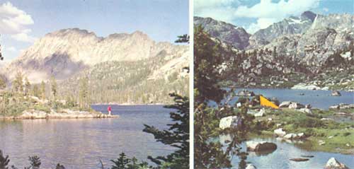
| Fisherman in the Sawtooth Primitive Area, (left), Sawtooth National Forest, Idaho F-519732 Camping at 10,000 feet, Cook Lake in the Bridger Wilderness (right) Bridger National Forest, Wyoming F-519733 |
| Wilderness | Date Created |
National Forest |
Acreage | Description |
| COLORADO | ||||
| La Garita | 1932 | Gunnison, and Rio Grande | 48,486 |
La Garita Wilderness takes its name from the Spanish term for "The Overlook." The La Garita features San Luis and Stewart Peaks, both over 14,000 feet. La Garita is noted for its alpine terrain astride the Continental Divide. Steep talus slopes and glacial rock deposits are common, and streams and lakes contain native cutthroat and eastern brook trout. La Garita generally is accessible from July through September. There is abundant wildlife in an alpine and subalpine setting. |
| Maroon Bells-Snowmass | 1933 | White River | 71,060 |
The 60-mile boundary of Maroon Bells-Snowmass Wilderness, encompasses one of the most picturesque regions in Colorado. Capitol, Snowmass, Maroon Bells, Castle, Pyramid and a host of other peaks and high ridges range from 12,000 to 14,259 feet. Challenging, yet accessible from boundary-line campgrounds, the "Bells" is a family favorite for horse or hiking travel. Conundrum Hot Springs, near timberline, gushes warm water. Visitors of long ago built a small bathing pool below the spring and the water is just a little above body temperature. Mountain sheep spend both summer and winter here. Most streams provide excellent fishing. |
| Mount Zirkel | 1931 | Routt | 72,472 |
Named for its highest point, 12,200-foot Mt. Zirkel, this area is noted for its many alpine lakes. More than 20 named lakes, plus nearly that many unnamed, are fishing favorites. The Sawtooth Range along the Continental Divide forms the nucleus of Mt. Zirkel. Scenery is spectacular with good fishing and hunting. Mt. Zirkel's boundaries lie close to developed recreation areas outside the Wilderness. The area is a summer range for elk. |
| Rawah | 1932 | Roosevelt | 26,674 |
The area is about 14 miles long and 3 miles wide. The name, "Rawah," means wilderness in the Ute Indian language. Elevations average 11,000 feet. The boundaries shelter 26 lakes, some prominent and others well hidden. Noted for its fishing waters, Rawah is one of the most popular Wildernesses in the Rocky Mountain Region. Part of the area is extremely rugged. |
| West Elk | 1932 | Gunnison | 61,412 |
The numerous streams in West Elk Wilderness flow to all points of the compass. Through the years, their constant downward rush has formed canyons with many interesting features. One such feature is the "Castles," which rise abruptly with sheer walls hundreds of feet high. Natural erosion has formed fantastic towers, minarets, and battlements, giving the formation every semblance of the feudal castles of Europe. The area ranges in elevation from 8,000 to 12,920 feet and is summer range for many deer and elk. |
| IDAHO | ||||
| Selway-Bitterroot | 1936 | Bitterroot, Clearwater, and Nezperce | 988,655 |
This is the largest classified Wilderness in the United States. Lying on both sides of the Bitterroot Range, which forms the boundary between Montana and Idaho, it includes large parts of the Lochsa and Selway River drainages in Idaho and the Bitterroot River in Montana. The Bitterroot, Clearwater, Lolo, and the Nezperce National Forests administer this huge area. The area is rich in history of Indians and early white men who found much of it impassable. With only occasional human visitors, much of this Wilderness remains as in ages past. It is difficult to grasp the immensity and variety of this area. Elevations range from 1,600 feet on the Selway River to over 10,000 feet in the Bitterroot Mountains. This provides for a variety of land forms, flora, and fauna. Seas of flame from wildfire have engulfed the area in the past, leaving only a few stands of huge old cedars in stream bottoms. One of the largest elk herds in the world roams this Wilderness. So great is the area, and so varied the Wilderness opportunities, that a year of exploration would still leave many parts unseen. Trails radiate into this area from access roads on all sides. (See under Montana also.) |
| MONTANA | ||||
| Anaconda Pintlar | 1937 | Beaverhead, Deerlodge, and Bitterroot | 157,803 |
An area of rugged mountains atop the Continental Divide in southwestern Montana. It is noted for its high, rugged, and beautiful mountain scenery where mountain goats make their home. One may view glacial cirques and alpine lakes, elk with their calves in the mountain meadows, inspiring views, and unusual stands of alpine larch trees. Sparkling streams, fed by perpetual snowbanks above timberline, tumble down steep canyons from the high mountain meadows. A variety of flora and fauna may be observed. Trails, including a "hi-line" trail along the top of the range, are plentiful for foot travelers or horseback riders. Cutthroat and rainbow trout fishing is excellent in lakes and streams. This Wilderness is named after the nearby town of Anaconda and Charles Pintlar, a pioneer trapper and early settler in the nearby Big Hole Valley. |
| Bob Marshall | 1931 | Flathead, and Lewis and Clark | 950,000 |
This Wilderness is noted for outstanding hunting, fishing, scenery, and geology. Extending 60 miles from north to south along the Continental Divide in northern Montana, it includes the headwaters of the Flathead River on the west and the Sun River on the east. Topography ranges from rugged, precipitous ridge tops, to gently sloping alpine meadows, to forested river bottoms. A 15-mile long Cambrian limestone reef on the crest of the Divide is called the "Chinese Wall" because its 1,000-foot vertical face suggests the Great Wall of China. Fossils of extinct animals a billion years old are found here. Game animals include the wolverine and grizzly bear, deer, elk, moose, black bear, mountain goat, mountain sheep, and mountain lion. Native black-spotted cutthroat and Dolly Varden trout are plentiful. |
| Cabinet Mountains | 1935 | Kaniksu, and Kootenai | 94,272 |
This northwest Montana Wilderness is composed of a series of prominent peaks and surrounding timbered valleys and ridges. Snow-clad peaks and glacial lakes; cold streams and cascading waterfalls; mountain goat and grizzly bear; large specimens of white pine and western red cedar; interesting rock specimens—all characterize this area. Here, one will find some of the most beautiful subalpine scenery in western Montana. Access roads from the nearby towns of Libby, Troy, Thompson Falls, and Noxon, lead to the Wilderness. Hiking, camping, hunting, fishing, and photography predominate. Due to very limited forage, horse use is not encouraged. A few peaks offer some technical climbing opportunities. Most western big-game animals inhabit this Wilderness. There is a wide variety of conifer trees, shrubs, and flowering plants. Huckleberries are abundant. Elevations range from 3,000 to 8,712 feet atop Snowshoe Peak. |
| Gates of the Mountain | 1948 | Helena | 28,562 |
Named for the mountains that seemed to bar passage of the Lewis and Clark Expedition up the Missouri River on their historic trek to the Pacific. This small Wilderness is of interest to hiking parties and is also suitable for horseback trips. One will view picturesque limestone cliffs and weathered rock formations. Trails pass through narrow gorges such as Refrigerator Canyon, so named because of the cool air flowing through a narrow passage among towering rock walls. A moss-like phlox covers the rocks with brilliant green. A great variety of flora adds color to the mountain meadows. Water is scarce, and streams sink into fissures and disappear. There are no fishing waters within the area, but fishing is excellent in the nearby Missouri River. Mountain goats are frequently seen in areas of deep canyons and towering cliffs; elk, deer, bear, and many smaller animals and birds are found in this Wilderness. Wild turkeys and vultures (turkey buzzards) are common. |
| Selway-Bitterroot | 1936 | Bitterroot, and Lolo | 251,950 |
A mountainous, wooded area lying mostly west of the Bitterroot Range, it contains wildlife and vegetation of great variety. With the Idaho section, it is the largest unit of the Wilderness System. (For details, see under Idaho.) |
| NEVADA | ||||
| Jarbidge | 1958 | Humboldt | 64,667 |
Rugged mountainous terrain with eight peaks over 10,000 feet. Deer are plentiful, small game and birds numerous, and good fishing in streams and one lake. One of the most scenic and remote spots in Nevada. |
| WYOMING | ||||
| Bridger | 1931 | Bridger | 383,300 |
Located in the Wind River Range with elevations from 9,500 to 13,785 feet on Gannett Peak, the highest in Wyoming, the area is characterized by massive granite outcrops. Hundreds of lakes and picturesque streams provide excellent fishing. Noted for mountain climbing and live glaciers. |
| North Absaroka | 1932 | Shoshone | 351,104 |
As its "sister" wilderness, the South Absaroka, this area is best known for its big-game hunting and for fishing. It is marked by steep canyons, etched through time by rushing streams. Home to the Shoshone Indian, the area served as a temporary haven for Chief Joseph of the Nez Perce. John Colter, discoverer of Yellowstone National Park, was one of the first mountain men to travel here. Today's wilderness explorer in the North Absaroka Wilderness discovers a region apparently untouched by civilization. It contains glaciers, a natural bridge, and standing petrified trees. |
| South Absaroka | 1932 | Shoshone | 483,130 |
The vast South Absaroka is a favorite of the early fall big game trophy hunter and the summer wilderness trail rider. Many of the trails hiked or ridden today were first made by the Shoshone Indians, who prized this area for its herds of mountain sheep, elk, deer, moose, and bear, including the grizzly. The area's many streams and lakes offer good trout fishing. Its great size, many miles of trails, and superlative scenery place the South Absaroka high on the list for a true wilderness experience. |
| Teton | 1934 | Teton | 563,500 |
This is a region of high plateaus, large valleys, and mountain meadows that can be easily traversed. Of special interest is Two Ocean Pass, where Two Ocean Creek divides and sends one stream to the Pacific and one to the Atlantic. Noted for elk hunting and fishing—it is summer range for the Jackson Hole elk herd. |
 | ||||
| PRIMITIVE AREAS | ||||
| COLORADO | ||||
| Flat Tops | 1932 | White River | 102,124 |
This is a land of violent contrasts—rolling lands, steep cliffs, jagged rocks, mountain peaks, open parks of grasslands, and densely timbered valleys. The major part of the famous White River big game herd of several thousand deer and elk use this area during the summer and fall. An abrupt, irregular border of lava rocks distinctly outlines the portion named "Flat Tops." There are about 160 miles of trails in this Primitive area. |
| Gore Range-Eagle Nest | 1933 | Arapaho, and White River | 61,101 |
The "Gore" is a favorite of backpacker and mountain climber. A network of 11 trails, totaling about 80 miles, leads the visitor through virgin forest, cascading streams, past deep clear lakes, in one of the most rugged mountain ranges in Colorado. This area literally stands on edge and is made up of a mass of sharp-pointed peaks, crests, and ridges. Great masses of snow perpetually lie on the almost vertical sides of this range. Mt. Powell, 13,534 feet, is the highest in the area. There are 17 peaks over 13,000 feet, 33 over 12,000 feet, and 40 that reach 11,000 feet in elevation. |
| San Juan | 1932 | San Juan | 238,407 |
This Primitive area includes the "Window" on the Continental Divide, a famous landmark mentioned often in diaries of early travelers and explorers. The area is a mecca of scenic beauty, recreational enjoyment, and a haven for wildlife. In a normal year it is impossible, because of snow, to reach the high country before July. The best time for travel begins about mid-July and lasts until mid-September. While the eye is continuously drawn to towering mountain peaks, beauty carpets the ground in a wide variety of vegetation. The 14,000-foot peaks of the Needle Mountains and Grenadiers offer the most popular climbing challenges. The area abounds in wildlife, including a grizzly bear management area. |
| Uncompahgre | 1932 | Uncompahgre | 53,252 |
Sheltered by the Uncompahgre Mountains, with peaks reaching to over 14,000 feet, the Uncompahgre contains countless lesser peaks, glaciated basins, small glistening lakes, and tumbling waterfalls. Half-hidden ruins of historic old mines and mining camps lure the history buff. Deer, elk, bear, bighorn sheep, grouse, wild turkey, ptarmigan, and trout are plentiful. Trails wind through sharp canyons, climb across lush mountain meadows, higher and higher, until the arctic-like alpine zone is reached. And, all around, a jagged line of peaks towers above. This area is a blend of man and nature—always inviting exploration. |
| Upper Rio Grande | 1932 | Rio Grande | 56,600 |
Bordering the giant San Juan Primitive Area is the jewel-like Upper Rio Grande Primitive Area. Situated on the slopes of the Continental Divide, the Rio Grande, with its many streams, forests, and open parks, is best described as "peaceful." Ringed with high mountain peaks, the terrain is such that any family group can enjoy its trails on foot or horseback. Camping and trout fishing are its major attractions. |
| Wilson Mountain | 1932 | San Juan, and Uncompahgre | 27,347 |
One of the smaller areas, Wilson Mountains is a favorite for both the mountain climber and the family. This area has survived early mining activity and other attempts by man to conquer it. Wilson Peak, Mount Wilson, and El Diente Peak, all over 14,000 feet, attract the serious mountain climber. Navajo Lake, featuring golden trout, draws the backpacking family. The countryside sparkles with wild flowers in mid-July. Large and small game are abundant. |
| IDAHO | ||||
| Idaho | 1931 | Boise, Challis, Payette, and Salmon | 1,224,733 |
A large, rugged, scenic, and mountainous area, with towering peaks and deep canyons. It embraces the Middle Fork of Salmon River, noted for flat boating and fishing. It offers exceptionally fine hunting with large herds of deer and elk. Bighorn sheep are a common sight along the river. |
| Salmon River Breaks | 1936 | Bitterroot, and Nezperce | 216,870 |
This Primitive Area is composed of both steep, rugged, riverbreak terrain, and forested, mountainous country. Located on the north side of the Salmon River, "River of No Return," it extends 40 miles through a roadless area midway between North Fork and Riggins, Idaho. Sport fishing for steelhead trout and salmon, big-game hunting for elk and mountain sheep, adventuresome white-water boating, and camping are the favorite activities. The riverbreak and mountain scenery are pleasures to be remembered or captured on film. History of Indians and white pioneers and miners are subjects for study. |
| Sawtooth | 1937 | Boise, Challis, and Sawtooth | 200,942 |
An exceptionally scenic area, it features the tooth-like Sawtooth Mountains with numerous deep gorges, glacial basins, with over 170 Alpine lakes. Fishing is good to excellent. The area is noted for wildlife including deer, elk, mountain goats, bear, mountain lions, and a variety of small game. |
| MONTANA | ||||
| Absaroka | 1932 | Gallatin | 64,000 |
This area lies just north of Yellowstone National Park. It is largely a forested, high mountain area with interspersed mountain meadows. Visitors are few due to the lengthy trail access from road ends. Solitude, therefore, becomes one of the primary attractions. Big-game animals within this Primitive Area are elk, moose, deer, bear—including a few grizzlies—mountain sheep, and mountain goats. Occasionally, an old renegade bull buffalo can be seen grazing the high ridges. Fishing is excellent in the larger streams and the one lake. From the higher ridges in the area, one can enjoy spectacular views of the surrounding peaks. Season of use is limited due to snow on the high mountain divides surrounding the area. |
| Beartooth | 1932 | Custer, and Gallatin | 230,000 |
This area is composed of Montana's most rugged country, often termed "unfinished country." It contains majestic peaks, deep canyons, high elevation tundra plateaus, and hundreds of lakes. The highest mountain in Montana, 12,799-foot Granite Peak, is located in the heart of this area. The true tests of man's ability to meet the challenges of Primitive living can be experienced here. Weather can be severe all months of the year. Much of this beautiful country lies exposed to nature's elements above timberline. Key attractions for the adventuresome are true glaciers, some of which contain grasshoppers—preserved for centuries in the ice—colorful waterfalls and cascades, bighorn sheep and goats, alpine meadows, and challenging peaks for experienced climbers. |
| Mission Mountain | 1931 | Flathead | 73,340 |
This relatively small area is located on the east side of the highly scenic and spectacular Mission Mountain Range north of Missoula. Entrance trails pass through majestic stands of virgin spruce, western larch, and fir. Much of the area can be seen only by hikers who travel without trails to the higher reaches of this rugged mountain range. Forage and trails are scarce, thereby limiting horse travel. The area receives heavy precipitation, mostly snow. Undergrowth, such as yew and snowbrush, is heavy and restricts travel at the lower elevations. Activities include mountain climbing, exploring rugged country, studying glaciers, photographing wildlife and beautiful scenery, hiking, camping, fishing glacial lakes, hunting mountain goats, elk, deer, bear—including grizzlies—or relaxation in a quiet, colorful natural setting. |
| Spanish Peaks | 1932 | Gallatin | 49,857 |
Visitors receive a rewarding experience as they travel through the timber-covered lower slopes, over grassy ridges, along tumbling streams, into high mountains, and up to the craggy, rugged mountain peaks. Named by the Crow Indian Tribe after finding six Spanish trappers in the vicinity in 1836, they called it "the canyon where the Spaniards stop." Alpine glaciation has produced spectacular features consisting of steep, rugged peaks, knife-edge ridges, and numerous cirques containing lakes surrounded by alpine meadows. Elevations range from 6,000 feet to 11,015 feet on Gallatin Peak. There are 25 peaks over 10,000 feet that probe the clear mountain air. Timberline is at about 9,000 feet. Moose, elk, deer, mountain sheep and goat, and black bear inhabit the area. Lakes and streams contain cutthroat, rainbow, brook, and grayling trout. Hiking, riding, camping, fishing, hunting, nature study, and photography highlight the activities of this scenic Madison Mountain Range. |
| UTAH | ||||
| High Uintas | 1931 | Ashley, and Wasatch | 237,177 |
The High Uinta Mountains, ranging from 8,000 to 13,449 feet, are the highest in Utah and the only major east-west range in the United States. A wild, picturesque region, rich in scenic, geological, and biological interest, the area is noted for fishing in over 250 small lakes. |
| MONTANA | ||||
| Cloud Peak | 1932 | Bighorn | 137,000 |
This area is named after its highest point, 13,165-foot Cloud Peak. Lowest point is the Main Fork of Paintrock Creek, lying at 8,500 feet. With a mean elevation of 10,000 feet, the season of use runs from about June 15 to September 15. Nearly vertical walls, 1,000 to 5,000 feet high, form a most impressive backdrop. The granite west side of Cloud Peak is dramatic in its gray solidity. Mather Peak and Blacktooth Peaks are breathtaking. Lake Solitude is the largest lake in the area; smaller mountain lakes are Crater, Cliff, and Geneva Lakes. Wildlife, including the tiny rock coney, the elk, moose, deer, mountain sheep, bear, fox, or his larger cousin. the coyote, adds to the primitive enjoyment. Cloud Peak contains 256 fishing lakes and 49 miles of fishing streams. |
| Glacier | 1937 | Shoshone | 177,000 |
This region of extremely rough and rugged topography has appeal to the hardy outdoorsman. It takes its name, not from ice-age history, but from some of the largest living glaciers within the continental United States. Much of the area is bare granite rock, planed off by recent or living glaciers. Highest peak is Gannet Peak, the highest point in the State of Wyoming, at 13,735 feet. There are numerous alpine lakes. |
| Popo Agie | 1937 | Shoshone | 70,000 |
Centuries of glacial action have resulted in a photographer's paradise in Popo Agie. Lying along the Continental Divide, the Popo Agie features over 200 lakes, high, jagged peaks, and deep narrow canyons, Seven major trails provide a journey through geologic history. Snow-storms and cold weather can be expected above timberline any time of the year. This high country is rarely open before mid-July. |
| Stratified | 1932 | Shoshone | 203,930 |
To the rockhound or geology buff, the Stratified area provides a never-ending succession of discovery. This area is rich in petrified remains of forests, ferns, and animal life. A hiking or horseback trek through the Stratified is a trip backward in time. Sections of petrified trees may be found on the gravel bars of almost all of the streams. Standing petrified tree trunks may be seen at the head of Frontier Creek. The area provides excellent hunting for big game, but only fair fishing. Campsites for wilderness travelers are numerous and well-distributed. |
THE SOUTHWEST
ARIZONA AND NEW MEXICO
Arid desert areas abound with the giant Saguaro cactus, gila monster, side-winder, tumbleweed, and sagebrush. There are snowcapped mountains as well as deep, sheer canyons that once housed early cliff dwelling Indians. The rocky peaks and isolated mountain fastnesses were the province of gold prospectors and early badmen.
Stands of pine and spruce grow in parklike array at higher elevations, receiving precious, life-sustaining water from runoff and storage of the deep winter snows.
Still visible on the arid desert floor are marks made by the great wagons of early settlers of the West. Deep within its National Forests, one can find roughly worded epitaphs on stone outcrops which commemorate forgotten skirmishes between the U.S. Cavalry and Indians.
The Spanish tried and failed to conquer this land—today you can trace Coronado's expedition across it. And you can visit Indian ruins of a civilization that reached its height long before the Spanish invaders came.
A timeless land—beautiful and forbidding.
|
| Escarpment in the Sycamore Canyon Primitive Area, Prescott National Forest, Arizona F-519734 |
| Wilderness | Date Created |
National Forest |
Acreage | Description |
| ARIZONA | ||||
| Chiricahua | 1933 | Coronado | 18,000 |
Jutting from the floor of the desert are the rugged pine-clad peaks of the Chiricahua Mountains. This "Island in the Desert" seemingly has been bypassed by modern civilization. A century ago, the mountains were the hunting grounds for Cochise and Geronimo. Variations in elevation, exposure, slope, and moisture provide a wide diversity of plant and animal life. Among the game species is the rare Chiricahua squirrel, found only in this vicinity. |
| Galiuro | 1932 | Coronado | 52,717 |
The Galiuro is a very rough, brushy desert mountain range, rising abruptly from the desert floor. The flanks form a series of spectacular cliffs and benches. The variety of plant species includes nearly every species common to southern Arizona. Travel is extremely difficult due to the steep topography and dense brush. Water is scarce and high temperatures discourage travel during summer months. For experienced outdoorsmen, there is good hunting. |
| Mazatzal | 1932 | Tonto | 205,137 |
Known locally as the "Ma-ta-zel" Wilderness, this area embraces the north end of the Mazatzal Range. These are predominantly desert mountains, exceedingly rough and precipitous, broken by narrow, vertical-walled canyons. Many peaks are carved out of solid rock. Those who visit the area find dramatic scenery, abundant and varied wildlife, striking climatic relief, and wild country that few people experience. Elevations range from 2,500 feet to 7,800 feet. Visitors should be prepared for difficult travel situations, and should carry water and other supplies. |
| Sierra Ancha | 1933 | Tonto | 20,850 |
This is exceptionally rough, scenic, and inaccessible country. The desert mountains include precipitous box canyons, high vertical cliffs, and prehistoric cliff dwellings. The extremely rough topography limits, and in some places prohibits, cross-country travel. Plant and animal species vary from those found on the desert to those found at 8,000 feet. The Wilderness is immediately adjacent to the Sierra Ancha Experimental Forest where many wildland management research programs are undertaken. Big game is abundant. |
| Superstition | 1939 | Tonto | 124,117 |
Before white men traveled through this rough desert area, the Superstition Mountains contained an element of mystery. Indian legends are numerous. The most famous story centers on the Lost Dutchman Gold Mine. Many people have died, some under peculiar circumstances, while searching for this mine and its fabled treasure. The area is spectacularly beautiful and rugged, but can be inhospitable to those not equipped to meet nature on her terms. Searing heat and a shortage of water are typical conditions in the summer. Bitter cold, torrential rains, and snowstorms are common in the winter. To those hardy enough to meet the challenges, this Wilderness offers scenic beauty, solitude, and a chance to study the many plants and animals indigenous to the area. |
| NEW MEXICO | ||||
| Gila | 1924 | Gila | 433,690 |
This area contains the first parcel of public land ever set aside to be managed for its wild and unspoiled quality. A part of the Mogollon Plateau, the area is sharply cut by steep, rugged canyons through which flow numerous streams and rivers. Archeological sites are common throughout, giving evidence of prehistoric habitation. Chief Geronimo is reputed to have spent considerable time here. With unique historic features, outstanding scenery, hunting, fishing, and solitude, this is an extremely popular and interesting Wilderness. |
| Pecos | 1933 | Carson, and Santa Fe | 167,416 |
This area lies at the southern end of the majestic Sangre de Cristo Mountains, at the headwaters of the Pecos River. The Pecos Wilderness includes some of the most beautiful and scenic country in New Mexico. Excellent fishing and hunting, magnificent scenery, and quiet solitude attract many visitors. Truchas Peak, second highest in New Mexico, provides a challenge for mountain climbers and ecologists who may observe rare species of plants and animals. Many lakes, more than 150 miles of streams, a 100-foot waterfall, and innumerable springs are in the area. |
| San Pedro Parks | 1931 | Santa Fe | 41,132 |
A high, moist plateau of rolling mountaintops with alternating areas of dense spruce and open mountain meadows—this is the San Pedro Parks Wilderness. Deer, bear, turkey, grouse, and elk regularly draw hunters. Fishermen rarely leave the small high streams empty-handed. The green beauty of the 10,000-foot-high "Parks" is a satisfying reward to the hiker or rider. |
| Wheeler Peak | 1960 | Carson | 6,027 |
The smallest Wilderness in the West, this area offers unusual and unique experiences. The focal point is Wheeler Peak, 13,161 feet, the highest point in New Mexico. The alpine tundra that covers Wheeler and other nearby peaks is rare in the Southwest. Plant and animal species here are found only in the real "high country." Small lakes and streams provide the source of several streams that are viral to downstream water users. |
| White Mountain | 1933 | Lincoln | 31,171 |
Rising from the surrounding desert, the White Mountains reach to over 12,000 feet just outside the Wilderness. In climbing from about 6,000 feet above sea level to an altitude of 11,400 feet, five life zones are encountered. These range from the desert grassland to the subalpine. This transition through life zones is one of the most rapid and abrupt found in any Wilderness, affording the botanist an excellent opportunity for study. The Wilderness overlies one of the few molybdenum "bonanzas" found in the western hemisphere. Evaluation and exploration of this deposit is being performed under a carefully regulated program. |
 | ||||
| PRIMITIVE AREAS | ||||
| ARIZONA | ||||
| Blue Range | 1933 | Apache | 180,139 |
Lying at the southern edge of the Colorado Plateau, the Blue Range is rugged and beautiful with many geologic and scenic attractions, including timbered ridges and deep canyons. The Mogollon Rim, made famous as the "Tonto Rim" in Zane Grey's books, crosses the area from west to east. This Rim, unique both from geological and ecological standpoints, is further enhanced by the spectacular Blue River Canyon and River. There is spruce and fir in the high country, with ponderosa pine in the lower elevations. Big game is abundant. |
| Mount Baldy | 1932 | Apache | 7,106 |
Cradling the headwaters of the West Fork of the Little Colorado River, this small area typifies the higher elevation of Arizona. From 8,700 feet to 11,000 feet, the topography varies from gently sloping timbered benches to extremely steep, rockstrewn mountainsides cut by deep canyons. This is the only wilderness-type area in the State that includes the subalpine vegetation zone. The climate contrasts sharply with the hot, dry valleys of Arizona's population centers. Big game is abundant, and there is 5 miles of fishing stream. |
| Pine Mountain | 1933 | Prescott, and Tonto | 16,399 |
Lying along the high Verde River Rim, the area stands as an island of tall, green timber, surrounded by desert mountains with hot, dry mesas and deep canyons. The timber is predominantly ponderosa pine. A great variety of wildlife and plants unfolds as the hiker or rider climbs through several life zones enroute to the top of Pine Mountain at 6,800 feet. Abundant big game, but hunting is difficult because of heavy cover and steep slopes and canyons. |
| Sycamore Canyon | 1935 | Coconino, Kaibab, and Prescott | 49,575 |
As the name implies, this area contains a unique canyonland environment. The canyon cuts through the Colorado Plateau at its southern edge, the Mogollon Rim, and winds 20 miles along Sycamore Creek, spreading as much as 7 miles from rim to rim. Wind and water have exposed seven geological eras, ranging in elevation from 3,600 feet to 7,000 feet. The changes in elevation result in a variety of contrasting ecological associations set in spectacular surroundings. Red sandstone, white limestone, and brown lava contrast markedly with many types of vegetation found in the canyons. Prehistoric ruins present evidence of vanished Indian culture. |
| NEW MEXICO | ||||
| Gila | 1933 | Gila | 130,637 |
From rolling, pinyon-juniper hills and grassy benches to rough, rocky canyons and timbered mesas, this area presents a broad spectrum of wild, primitive country. It was set aside to preserve some of the geological, topographical, and ecological features not found within other Wildernesses nearby. Game is plentiful, although fishing is limited in this semiarid portion of the Mogollon Mountains. Once known as "Apacheria," or land of the Apache Indians, this area is rich in history, geology, archeology, and rugged scenery. |
| Black Range | 1933 | Gila | 169,356 |
The Black Range Primitive Area was created to preserve the wild characteristics and resources of the rugged Black Range of mountains. The rough, rocky canyons and peaks offer solitude, coupled with pleasing scenery, and relief from high desert temperature. Scars from very old forest fires are evident throughout the area. More recent wildfires provide study opportunities in ecological succession. Big game is not abundant and fishing is limited, although Diamond Creek supports the Gila Trout, a species that is almost extinct. The famous Apache Chief Geronimo used the Black Range as a hideout. |
| Blue Range | 1933 | Apache | 36,598 |
The Blue Range is traversed by the Mogollon Rim with spruce and fir in the high country and with ponderosa pine in the broken country below. Big game is abundant. (For details, see under Arizona section.) |
THE LAKE STATES
MINNESOTA
The BWCA is unique in the National Forest Wilderness Systems—it is the only lakeland Wilderness. It contains more than a thousand lakes, 10 acres in size or larger—more lakes than all but a handful of States can boast. There is an acre of water for every 5 acres of land in this million-acre tract. It is truly a "water wilderness."
As one paddles through the labryinth of Wilderness lakes and streams of the Canoe Area, forested land creates a scenic backdrop for the voyage. On portages and at campsites, you will come to know these forests intimately, and you will sense their endless variety. In some areas the trees are young and small; in others they are large and old, and the species often change abruptly.
This area also is unique in that the Wilderness Act provides that it continue to be managed under special regulations of the Secretary of Agriculture, which permit controlled use of motors and the harvest of timber in portions of the area.
|
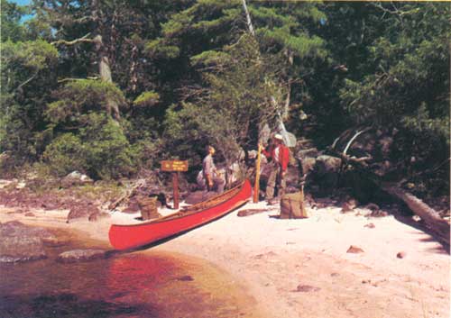
| Lac La Croix portage in the Boundary Waters Canoe Area, Superior National Forest, Minnesota F-498986 |
| Wilderness | Date Created |
National Forest |
Acreage | Description |
| MINNESOTA | ||||
| Boundary Waters Canoe Area | 1926 | Superior | 747,128 |
Jagged rocks and lush undergrowth sprawl beneath the forest canopy of this lakeland Wilderness—dotted with over 1,000 lakes and laced by a network of streams and rivers. There is excellent fishing in more remote areas of this largest Wilderness east of the Rockies—one of the largest in the system. Here, the modern-day voyageur can follow the routes of the Chippewa and Sioux, and the early day trappers and fur traders. |
 | ||||
THE SOUTHEAST
NORTH CAROLINA
Hardwoods in the Southern Appalachians grow higher than any other hardwoods on the continent. Here, the straight boles of the tulip poplar rise more than 100 feet without limbs and jut far above the surrounding oaks. In small openings of the forest grow dense clumps of laurel and azalea which in May and June blossom forth in brilliant orange, pink, and cardinal.
There is history in the mountains of the southern National Forests. Forestry in the United States was born in the mountains of western North Carolina, and its site is marked as the "Cradle of Forestry." Here, America's first forestry school has been re-created at the old Vanderbilt Estate near Asheville, North Carolina, with buildings just as they were at the turn of the century.
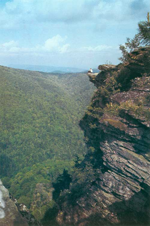
|
| Linville Gorge from Wiseman's View in the Linville Gorge Wilderness, Pisgah National Forest, North Carolina F-519736 |
| Wilderness | Date Created |
National Forest |
Acreage | Description |
| NORTH CAROLINA | ||||
| Linville Gorge | 1951 | Pisgah | 7,575 |
This area is spectacularly beautiful, with steep slopes, curious rock formations, and overhanging cliffs. For 12 miles, the Gorge encloses the Linville River which drops 2,000 feet into the valleys below. There are many varieties of plants and wildlife. Wiseman's View offers picnicking and a commanding view of the Gorge. Camping is permitted, but there are no facilities. The area is extremely rugged and those entering should notify the District Ranger at Marion. |
| Shining Rock | 1963 | Pisgah | 13,350 |
This tract has scenic waterfalls, outstanding, wildlife, and unusual vegetative cover. Its unique geological formations range from the steep outcropping of white quartz that is Shining Rock to gentle, undulating slopes. Elevations rise from 3,500 to 6,033 feet at Cold Mountain. Trails go into much of the area, and springs are numerous. Camping is permitted, but there are no facilities. Unusual care should be taken with fire. |
THE NORTHEAST
NEW HAMPSHIRE
On the eastern slopes of the Presidential Mountain Range, a narrow, steep-sided gulf offers a retreat into the solitude once known only to our forefathers.
Called the Great Gulf, this valley, 1,100 to 1,600 feet deep, is located between Mt. Washington and the Northern Peaks and extends 3.5 miles eastward from Mt. Washington. The rugged topography creates a feeling of remoteness from civilization. Only a few scattered stands of virgin spruce have remained unscathed from the hurricanes that have tormented the area.
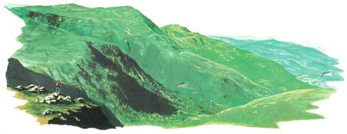
|
| Mt. Jefferson, Mt. Adams, and Mt. Madison, Great Gulf Wilderness, White Mountain National Forest, New Hampshire F-476932 |
| Wilderness | Date Created |
National Forest |
Acreage | Description |
| NEW HAMPSHIRE | ||||
| Great Gulf | 1959 | White Mountain | 5,552 |
The Great Gulf rises from valley depths of 1,600 feet to merge with the eastern slopes of Mount Washington and the Presidential Range reaching to 5,800 feet. Gouged out of surrounding mountains by glaciers, the spruce and fir of its upper reaches have been torn away by recurrent hurricanes, although hardy and colorful alpine flowers return annually to its barren crest. Descending into the "Gulf," the growth of conifers and scattered hardwoods becomes lush, with varied wildlife. The West Branch of the Peabody river cuts an arc across these acres, and in the upper reaches, are two lakes—Spaulding Lake and Star Lake. Because of its remoteness, hunting is difficult, although deer are found up to 3,500 feet, and snowshoe rabbits range up to the tree line. |
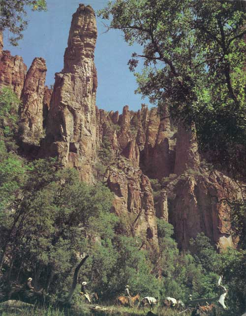
|
| Middle Fork of the Gila River, Gila Wilderness Gila National Forest, New Mexico |
| <<< Previous | <<< Contents>>> |
|
PA-942/sec2.htm Last Updated: 12-Sep-2011 |