|
The Clearwater Story: A History of the Clearwater National Forest |
|
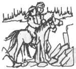
Chapter 2
Lewis & Clark East
Starting at Weippe Prairie.
June 11, 1805. Clark: "Collected our horses early with intentions of making an early start. Some hard showers detained us until 10 A.M. at which time we took our final departure from the Quamash Flats (Weippe) and proceeded with much difficulty, due to the slippery road. At nine miles we passed a small prairie (Crane Meadows) in which was quamash. At two miles further we are at the camp of Fields and Willard on Collins Creek (Lolo). They arrived at this creek last evening and killed another deer near the creek."
"Here we let our horses graze in a small glade and ate dinner. (This is the so-called Wolf Camp on Lolo Creek.) After detaining about two hours, we proceeded on, passing the creek three times and passing over some rugged hills and spurs, passing the creek on which I camped Sept. 17 (Cedar Creek). (Clark is in error. This should be Sept. 19.) Came to a small glade of about ten acres thickly covered with grass and quamash near a creek (Eldorado) and encamped."
"We passed through bad fallen timber and a high mountain this evening. From the top of this mountain I had an extensive view of the Rocky Mountains to the south and the Columbia Plains for a great extent. Also in the southwest a range of high mountains which divides the Lewis and Clark Rivers covered with snow."
Comment: Apparently the ridge between Cedar and Eldorado Creeks had been burned over, because Clark complained of windfalls and was able to view the surrounding country much better than you can do from this point today.
The Columbia Plains that he wrote about are, of course, the Nez Perce and Camas Prairies. The high mountains between the Snake and Salmon Rivers are the Seven Devils.
June 16, 1806. Lewis: "We collected our horses very early this morning, took breakfast and set out at 6 A.M. Proceed up the creek (Eldorado) about two miles through some handsome meadows of fine grass, abounding with quamash. Here we passed the creek (Eldorado) and ascended a ridge which led us to the N.E. about seven miles, when we arrived at a small branch of Hungery Creek (actually a branch of Fish Creek). The difficulty we met with fallen timber detained us so much we arrived at 11 A.M.
"Here is a handsome little glade in which we found some grass for our horses. We, therefore, halted to let them graze and took dinner, knowing there was no other place suitable for that purpose short of the glades on Hungery Creek, where we intended to camp.
"Before we reached this little branch on which we dined, we saw in the hollows and north hillsides large quantities of snow, in some places two feet deep.....However, we determined to proceed. Accordingly after taking a hearty meal, we continued our route through a thick wood with much fallen timber and intersected by many small ravines and high hills."
"The snow increased in quantity so much that the greater part of our route this evening was over snow, which has become sufficiently firm to bear our horses. Otherwise it would have been impossible to pass, as it lay in masses, in some place 8 to 10 feet deep. We had much difficulty in pursuing the road, as it was so frequently covered with snow."
"We arrived early at the place that Capt. Clark had killed and left the horse for us last September. Here is a small glade in which there is some grass. Not a sufficiency for our horses, but we thought it most advisable to remain here all night, as we anticipate if we proceed further we should find less grass.....We came 15 miles today."
Comment: The party proceeded up Eldorado Creek, crossed it and then up the ridge between Dollar and Sixbit Creeks, over the main divide into the drainage of Fish Creek, where they found a small meadow and lunched. They then went over another divide into Hungery Creek and camped at a small meadow. This meadow is unmarked and not on the maps but it is just below Windy Saddle on the road to Boundary Peak.
June 17, 1806. Clark: "We collected our horses and set out early. We proceeded down Hungery Creek about seven miles, passing it twice. We found it difficult and dangerous to pass the creek in consequence of its depth and rapidity. We avoided two passes of the creek by ascending a steep, rocky difficult hill."
"Beyond the creek the road ascends the mountains to the height of the main ridges, which divides the waters of the Kooskooske (Lochsa) and Chopunnish (North Fork) Rivers. This morning we ascended about 3 miles, when we found ourselves enveloped in snow from 8 to 12 feet deep, even on the south side of the mountains."
"I was in front and could only pursue the direction of the road by the trees which had been peeled by the natives for the inner bark, which they scrape and eat. As these trees were scattered, I with great difficulty, pursued the direction of the road one mile further to the top of the mountain, where I found snow from 12 to 15 feet deep. Here it was winter with all its rigors. The air was cold and my hands felt benumbed."
"We knew it would require 4 days to reach the fish weir at the entrance of Colt Killed Creek (White Sand), provided we were so fortunate as to be able to follow the proper ridge of mountains to lead us there. Of this all of our most expert woodsmen and experienced guides were extremely doubtful. Short of that point, we could not hope for any food for our horses."
"If we proceeded and should get bewildered in these mountains, the certainty was that we would lose all our horses and consequently our baggage, instruments, perhaps our papers, and then eventually risk the loss of our discoveries which we had already made, if we should be so fortunate to escape with life.....Under these circumstances we decided it madness in this stage of the expedition to proceed without a guide."
"We, therefore, came to the resolution to return with our horses while they were yet strong and in good order, and endeavor to keep them so until we could procure an Indian to conduct us over the snowy mountains. Having came to this resolution, we ordered the party to make a deposit of our baggage which we did not have an immediate use for; also the roots, bread or cowis which they had, except an allowance for a few days to enable them to return to a place at which we could subsist by hunting until we obtained a guide."
"Our baggage being on scaffolds and well covered, we began our retrograde march at 1 P.M., having remained about three hours on the snowy mountain. We returned by the route we advanced from Hungery Creek which we ascended about two miles and camped.....The party was a great deal dejected, though not as much as I anticipated."
Comment: The mountain on which the baggage was deposited is just west of Sherman Saddle and although it is unnamed on the map it is locally known as Willow Ridge. Their camp that night was on the south side of Hungery Creek. It is marked on the ground with an iron post.
June 18, 1806. Clark: "This morning we had considerable trouble in collecting our horses, they having straggled off to a considerable distance in search of food on the sides of the mountain in thick timber. At 9 o'clock we collected them all except two, one of which was Shield's and one Drewyers. We set out leaving Shields and LePage to collect the two horses and follow us.
"We dispatched Drewyer and Shannon to the Chopunnish Indians in the plains beyond the Kooskooske in order to hasten the arrival of the Indians who promised to accompany us, or to procure a guide at all events, and rejoin us as soon as possible. We sent by them a rifle, which we offered as a reward to any of them who would engage to conduct us to Clark's (Bitterroot) River at the entrance of Travelers Rest (Lolo) Creek. We also directed them, if they found difficulty in inducing any of them to accompany us, to offer the reward of two other guns to be given to them immediately, and ten horses at the falls of the Missouri (Great Falls, Montana)."
We had not proceeded far this morning before J. Potts cut his leg very badly with one of the large knives. He cut one of the large veins on the inner side of the leg."
"Colter's horse fell with him in crossing Hungery Creek. He and his horse were carried down the creek a considerable distance, rolling over each other among the rocks. He fortunately escaped without much injury or the loss of his gun. He lost his blanket."
"At 1 P.M. we arrived at the glade where we dined on the 16th. Here again halted and dined. As there were some appearance of deer about this place, we left J. and R. Fields with directions to hunt this evening and tomorrow morning at this place and join us tomorrow evening at the meadows on Collins (Lolo) Creek, where we intend to stay tomorrow to rest and hunt."
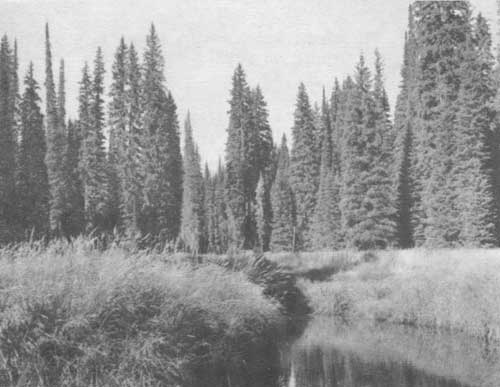
"After dinner we proceeded on to the fork of Collins Creek (Eldorado) and camped in a pleasant situation at the upper part of the meadows about two miles above our encampment of June 15. We sent out several hunters, but they returned without killing anything. They saw a number of large fish in the creek and shot at them several times without success. We ordered Gibson and Colter to prepare giggs in the morning to take some of the fish. The hunters saw much fresh appearance of bear, but very little deer sign. We hope by means of the fish and what deer and bear we kill to subsist until our guide arrives, without the necessity of returning to the Quamash Flat (Weippe). There is an abundance of food here to sustain our horses. . . . Mosquitoes troublesome."
Comment: The party retraced its route to Eldorado Creek and camped at the mouth of Dollar Creek. The present Forest Service road crosses Eldorado Creek at this point.
The mosquitoes at Eldorado Meadows come after you in swarms in the spring of the year. I don't see how they endured them.
June 19 and 20, 1806: The party stayed at Eldorado Meadows hunting, fishing, and fighting mosquitoes. Hunting was poor so they decided to return to Weippe Prairie. The lost horses were not found.
June 21, 1806. Lewis: The party returned to Weippe and "found ourselves at our old encampment". They met two Indians enroute who had part of their lost stock, which included a mule.
June 22 and 23 were spent at Weippe hunting with very good success. At 3 P.M. of the 23rd Shannon and Drewyer returned with three Chopunnish guides.
June 24, 1806. Lewis: "We collected our horses early this morning and set out, accompanied by our three guides .....we nooned it at Collins Creek .....After dinner we continued our route to Fish (Eldorado) Creek, a branch of Collins Creek where we had lain on the 19th and 20th. We had fine grass for our horses this evening."
Comment: With food, good horses and three expert Nez Perce guides, they were ready to make a second assault on their much feared foe, the Bitterroot Mountains. Notice in the next few days that these guides never miss. They waste no time looking for the trail and camp at horse feed every night. It is unfortunate that none of those who kept diaries gave the names of their Nez Perce guides. Some Indians say one the guides was a son of Twisted Hair and another the son of Red Grizzly.
|
| On their trip east in 1806 Lewis and Clark camped at Eldorado Meadows for two days of hunting, fishing, and fighting, "troublesome mosquitoes." |
|
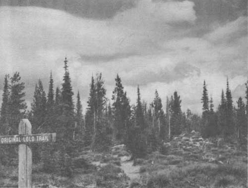
| The Lolo or Lewis and Clark Trail is still visible today atop the ridge which divides the Kooskooskee (Lochsa) and Chopunnish (North Fork of the Clearwater) Rivers. |
June 25, 1806. Lewis: "Last evening the Indians entertained us by setting the fir trees on fire. They placed a great number of dried limbs near the trunk, which when set on fire creates a very sudden and immense blaze from bottom to top of these tall trees. They are beautiful in this situation at night. This exhibition reminded me of a display of fireworks. The natives told us that their object in setting the trees on fire was to bring fair weather for our journey."
"We collected our horses at an early hour this morning. One of our guides complained of being unwell, a symptom I did not much like, as such complaints with an Indian is generally the prelude to his abandoning any enterprise with which he is not well pleased. We left them at our encampment and they promised to pursue us in a few hours."
"At 11 A.M. we arrived at the branch of Hungery Creek, where we found R. and J. Fields. They had not killed anything. Here we halted and dined and our guides overtook us. (This is the third time that they nooned it here.) After dinner we continued our route to Hungery Creek and encamped about one and a half miles below our camp of June 16.
"The Indians continue with us and I believe are disposed to be faithful to their engagements. I gave the sick Indian a buffalo robe, he having no other covering except his mocassins and a dressed elk skin without the hair."
"Drewer and Shields were sent on this morning to Hungery Creek in search of their horses, which they fortunately recovered."
Comment: Being a retired forester and a firefighter I cannot help wondering how far the fires that were set spread during the following summer.
June 26, 1806. Lewis: "This morning we collected our horses and set out after an early breakfast, or at 6 A.M. We passed by the same route we had traveled on the 17th to our deposit on the top of the snowy mountain to the N.E. of Hungery Creek. Here we halted two hours to arrange our baggage and prepare our loads. We cooked and ate a hasty meal of boiled venison and cowis."
"The snow has subsided near four feet since the 17th. We now measure it accurately and found from a mark we had made on a tree when we were last here on the 17th that it was then 10 feet 10 inches, which appeared to be about the common depth, though it is deeper still in some places. It is now generally about 7 feet."
"On our way up this mountain we killed two of the small black pheasants (fool hens or Franklin grouse) and a male of the larger dominecker or speckled pheasant (blue grouse).....The Indians inform us that neither of these species drum. They appear to be very silent birds, for I have never heard any of them make a noise in any situation."
"The Indians hasten to be off and informed us that it was a considerable distance to the place which they wished to reach this evening, where there was grass for our horses. Accordingly we sent out with our guides, who led us over and along the steep sides of tremendous mountains entirely covered with snow except about the roots of trees, where the snow had sometimes melted and exposed a few square feet of earth."
"We ascended and descended several lofty heights, but keeping on the dividing ridge between the Kooskooske and Chopunnish Rivers, we passed no stream of water. Late in the evening, much to our satisfaction and the comfort of the horses, we arrived at the desired spot and encamped on the steep side of a mountain convenient to a good spring. There we found an abundance of fine grass for our horses. This situation was the side of an untimbered mountain with a southern aspect, where the snows, from appearance had been dissolved about 10 days. The grass was young and tender, of course, and had much the appearance of a lawn."
Comment: The Indians were correct; neither the Franklin or blue grouse drum. But they do make noises. During the mating season the male blue grouse makes a grunting sound, or ump—ump—ump. The foolhen makes a snapping noise while strutting. The female of both species call their young by clucking sounds.
The party camped at Bald Mountain, which has been a favorite camping ground for parties traveling the Lolo Trail due to its abundant grass.
June 27, 1806. Lewis: "We collected our horses and set out. The road still continues on the heights of the same dividing ridge on which we traveled yesterday for 9 miles to our camp of Sept. 17. About one mile short of this camp, on an elevated point, we halted by the request of the Indians a few minutes to smoke the pipe."
"On this point the natives have raised a conic mound of stones of six or eight feet high, and on its summit erected a pine pole 15 feet long. From thence, they inform us, that passing over with their families some of the men were usually sent on foot by the fishery at the entrance of Colt Killed Creek (White Sand) in order to take fish and again meet the main party at the Quamash Glade (Packer Meadows) at the head of the Kooskooske River."
"From this place we had an extensive view of the stupendous mountains, principally covered with snow like that on which we stood. We were entirely surrounded by these mountains, from which, to one unacquainted with them, it would seemed impossible ever to have escaped. In short, without the service of our guides, I doubt much whether we, who once passed them, could find our way to Traveler's Rest Creek (Lolo, Montana). These fellows are most remarkable pilots. We find the road wherever the snow has disappeared, though it be only for a few paces."
"After smoking the pipe and contemplating this scene we continued our march, and at the distance of three miles, descended a steep mountain and passed two small branches of the Chopunnish River just above their forks, and again ascended the ridge on which we passed several miles, and at a distance of seven miles arrived at our encampment of Sept. 16, near which we passed three small branches of the Chopunnish River and again ascended the dividing ridge, on which we continue 9 miles, when the ridge becoming lower and we arrived at a station very similar to our encampment of last evening, though the ridge was somewhat higher and the snow had not been so long dissolved. Of course, there was little grass. Here we encamped for the night, having traveled 28 miles over these mountains without relieving our horses from their packs or their having food."
"The Indians inform us that there are, in the mountains to our left, an abundance of mountain sheep, or what they call white buffalo (mountain goats in the Blacklead area). We saw three mule deer this evening but were unable to get a shot at them. We also saw several tracks of these animals in the snow."
"The Indians inform us that there is a great abundance of elk in the valley about the fishery of the Kooskooske River."
"Our meat being exhausted, we issued a pint of bears oil to a man, which with their boiled roots, made an agreeable dish."
"Pott's leg which had been swollen and inflamed for several days, is much better this evening and gives him but little pain."
Comments: The rock mound on which the Indians stopped to smoke is located on the first high point west of Indian Grave. It is off the Lolo Motorway but on the old Lolo Trail. There is a small rock mound there now, much smaller than the one Lewis and Clark described. It could be the same mound much settled, or it may be that another one was erected. There are a number of old rock cairns along the Lolo Trail. They camped at Spring Hill called Red Mountain by the Nez Perce for the dock on it which turns red in the fall.
June 28, 1806. Clark: "This morning we collected our horses and set out early as usual, after an early breakfast. We continued our route along the dividing ridge over knobs and deep hollows. Passed our camp of Sept. 14 last near the forks of the road, leaving the road on which we had come, one leading to the fishery on our right immediately on the dividing ridge."
"At 12 o'clock we arrived at an untimbered hillside of a mountain with a southern aspect just above the fishery. Here we found an abundance of grass for our horses, as our guide informed us. As our horses were hungry and much fatigued and from our information no other place where we could obtain grass for them within the reach of this evening's travel, we decided to remain at this place all night, having come 13 miles only."
Comment: Gass adds that they saw numerous elk tracks at this camp ground. This is the only time elk tracks are mentioned in the Clearwater Valley.
The party has taken a shorter route than that taken westward and have arrived at Powell Junction near the place where the road goes to Rocky Point Lookout.
June 29, 1806. Clark: "We collected our horses early and set out, having previously dispatched Drewyer and R. Fields to warm springs (Lolo Hot Springs) to hunt. We pursued the heights of the ridge on which we have been passing for several days. It terminated at the distance of five miles from our camp and we descended to and passed the main branch of the Kooskooske (Crooked Creek) one and a half miles above the entrance of Glade (Brushy) Creek, which falls in on the N.E. side. When we descended from the ridge we bid adieu to the snow."
"Near the river we found a deer which the hunters had killed and left us. This was a fortunate supply, as our oil was now exhausted and we were reduced to roots alone, without salt. The Kooskooske at this place is about 30 yards wide and runs with great velocity. The bed, as of all the mountain streams, is composed of smooth stones."
"Beyond the river we ascended a very steep mountain about two miles, and arrive at the summit, where we found the old trail by which we passed when we went west, coming in from the right. The road was now much plainer and more beaten, which we were informed happened from Ootshashoots (Flatheads or Salish) visiting the fishery frequently from the valley of the Clark's (Bitterroot) River, though there was no appearance of their having been there this spring."
"At noon we arrived at the quamash flats and halted to graze our horses and dine, having traveled 12 miles. We passed our camp of Sept. 13 at 10 miles. We halted at a pretty plain of about 50 acres plentifully stocked with quamash and from appearances this forms one of the principal stages or encampments of Indians who pass the mountains on this road."
After dinner we continued our march 7 miles to the warm springs where we arrived early in the evening and sent out several hunters." (Here the warm springs are described. The party, including the guides, bathe in the warm water.)
Comment: The ridge they were following ended at Rocky Point and they descended to and crossed Crooked Fork Creek. They then climbed the ridge to the southeast and came to their old trail, which they followed to Packer Meadows, lunching at the eastern edge. They then went to Lolo Hot Springs and camped.
| <<< Previous | <<< Contents>>> | Next >>> |
|
clearwater/story/chap2.htm Last Updated: 29-Feb-2012 |