|
Trails of the Past: Historical Overview of the Flathead National Forest, Montana, 1800-1960 |
|
INTRODUCTION
(Northern Region News banner, 7 March 1938)
The history of the Flathead National Forest is closely tied to that of the Flathead Valley. This historic overview attempts to place developments on the Flathead National Forest into the broader context of developments in the Flathead Valley and beyond, both within and outside the Forest Service. The changing uses of Flathead National Forest lands reflect larger social and technological changes occurring in the United States at the same time. This overview does not address Native American use of the land in any detail because that important topic is to be the subject of a prehistoric overview of the Flathead National Forest.
In 1897 the U. S. Congress created the two forest reserves that later became known as the Flathead National Forest. Until the 1940s, the major management activities on the Forest centered on fire detection and suppression, trail building, the installation of an extensive backcountry telephone network, running big-game surveys, and the administration of forest homestead applications and a limited number of commercial timber sales. World War II marked a turning point in the management of the Flathead and other national forests. Subsequently, timber sale volumes increased dramatically, as did the public demand for recreation, and the system of fire detection changed from its previous emphasis on manned lookouts to the use of aerial patrols.
In the past several decades, competing interests in the resources of the national forests have led to conflicts over how best to manage the natural and man-made resources within the Forests. The public has become increasingly involved in the decision-making process as the various "multiple uses" of the national forests are weighed and day-to-day and long-term management decisions are made. The term "ecosystem management" has recently become popular to describe the agency's broader perspective on managing the land for which it is responsible. Change, as usual, is in the wind, due to relatively recent federal laws and to a new generation of professionals working within the Forest Service.
An understanding of human attitudes, policies, and actions on the land in the past improves decisions made today. This overview relies heavily on written documents to provide an understanding of the impacts of humans on the land in the Flathead Valley area from the years 1800 to 1960. Much can also be learned from the land itself, its vegetation and topography, and the physical remains of past human activity.
The physical evidence of the history of the Flathead National Forest is varied, and it is often fascinating to visit on site. Although some cultural resources have been destroyed by wildfire and many others by natural deterioration or intentional demolition, other resources remain to enlighten us today. Some of these are described briefly in the chapter introductions that follow. In addition, many names of mountains, creeks, and other natural features reflect earlier uses of the area, while others memorialize specific people.
It is difficult, in today's world of highway transportation, prepared foods, and computers, to comprehend the world of a Forest Service ranger in, say, 1915. The Flathead National Forest provides some of the best opportunities in the nation to enter this world of the past. Travel into the remote backcountry on foot or by horse, be sure to bring your imagination, and gain a sense of the challenges and privileges experienced by these early custodians of the national forests. But most important, get a sense of the land; the history of the Flathead National Forest is, after all, firmly rooted in the land itself.
The Flathead National Forest encompasses several million acres of land in northwestern Montana. The changing management of these public lands has played a significant role in the development of the Flathead Valley over the years, particularly in the fields of fire management, timber management, and recreation. Some Flathead National Forest employees spent their entire careers on the Flathead; others worked on many different national forests. The story of these workers - their evolving goals, their challenging working conditions - follows. But above all, the story of the Flathead National Forest is the story of the land. The history of the Flathead Valley has been shaped by its topography, the limitations the land imposes, and the opportunities it affords to the humans in the area.
Note on the Various Names of the Flathead National Forest
The land managed by the Forest Service in the northern Rockies just south of the international boundary has been known by several different names over the years, as follows:
The north portion (Stillwater, North Fork) has been called:
| 1897-1903 | Flathead Forest Reserve |
| 1903-1907 | Lewis & Clarke Forest Reserve North |
| 1907-1908 | Lewis & Clark National Forest North |
| 1908-1933 | Blackfeet National Forest |
| 1933-present | Flathead National Forest |
The south portion (South Fork, Middle Fork) has been called:
| 1897-1903 | Lewis & Clarke Forest Reserve |
| 1903-1907 | Lewis & Clarke Forest Reserve South |
| 1907-1908 | Lewis & Clark National Forest South |
| 1908-present | Flathead National Forest |
Throughout this historical overview, the appropriate name of the forest reserve or national forest is used when discussing an event at a specific date and location. The name "Flathead National Forest" is used when discussing general events on the Forest; in these cases, it implies the present boundaries and thus would include both the north and south halves of the Forest but not the lands transferred during the historic period to other agencies or national Forests.
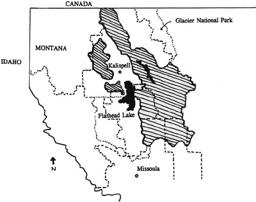
The boundaries of the Flathead National Forest have changed greatly over the decades. The current (1985) boundaries are shown in Figure 1.
|
| Figure 1. Map of Flathead National Forest and vicinity (FNF "Forest Plan" 1985). |
| <<< Previous | <<< Contents>>> | Next >>> |
|
region/1/flathead/history/intro.htm Last Updated: 18-Jan-2010 |