|
The National Forests of the Northern Region Living Legacy— |
|
Chapter 2
The Fur Trade
Settlement and Development
The entry of European and Anglo-American settlers into the northern Rocky Mountain region altered traditional resource use patterns. Native Americans living in the region at the time of the first European penetration comprised a wide variety of cultures and corresponding resource-use patterns. Yet all shared a similar world view and a level of technology that helped define their place within the natural world and that dictated limits to their effect on the environment.
Native Americans' lives were closely attuned to the physical world. They saw themselves as physically and spiritually linked with the rest of nature. Their system of land tenure was communal, with no concept of dividing the Earth into individually owned plots. Aspects of their material culture arose directly from the resources of their surrounding environment. Some activities, such as bark stripping or fire setting on the plains or in forests, altered natural life cycles, but nature could always readjust and incorporate the limited destruction into its cycles. [1]
Europeans brought a very different set of values to the Northern Region. Their intellectual heritage separated humans from nature. Many ancient European folk legends identified wilderness with monstrous, supernatural creatures and threats to security. Nature was for most Europeans something against which to do battle—to tame, to civilize, and ultimately to conquer. [2] Europeans also had a much more sophisticated level of technology and a complicated market economy. Their ability to produce and their capacity to consume goods, therefore, far surpassed that of Native American societies. This would result in tremendous growth in the demand for resources. The fur trade, then mining, and, by the end of the 19th century, the railroad significantly altered traditional patterns of resource use.
The Fur Trade
The British North West Company brought into the region the first Europeans whose goal was to exploit valuable commodities. Prodded by news of the Lewis and Clark expedition, the company put David Thompson, a talented surveyor and geographer, in charge of opening a fur trade in the area of the headwaters of the west-flowing Columbia, Kootenai, and Clark Fork Rivers. A crew under Thompson entered into what is now Idaho in the spring of 1808 and set up a trading house near Bonners Ferry. [3]
The following fall, Thompson sent Finan McDonald to a site near present-day Libby, Montana, where he and his men constructed Kootenai Post. Thompson and a team of employees then built Kullyspell House on the eastern shore of Pend Oreille Lake in the summer of 1809; later that fall, they established the Saleesh House on the Clark Fork, close to the present-day town of Thompson Falls. Although Thompson left the area shortly thereafter, he had strengthened Britain's presence in the western portion of the region by initiating a brisk trade with the Kootenai and with several of the nearby Salishan tribes. [4]
Meanwhile, American traders in St. Louis, excited by Lewis and Clark's reports hurriedly made plans to tap the fur wealth in the eastern portion of the region (sometimes called the upper Missouri country). One of them, Manuel Lisa, recruited George Drouillard and John Colter of the Lewis and Clark expedition immediately after their return and ventured back up the Missouri River in the spring. Lisa and his men set up a post at the mouth of the Yellowstone River in the fall of 1808; the following autumn, Lisa sent Drouillard to look for beaver and encourage trade with Native Americans. Drouillard journeyed east across the Little Big Horn and Rosebud Rivers to the Tongue River, where he encountered several Crow encampments. Eventually, he produced the first maps of the Tongue River area. [5]
Lisa spent the winter of 1808-09 organizing St. Louis businessmen into the Missouri Fur Company to finance his operations. The new firm quickly established trade relations with the Crows. However, similar relations with the Blackfeet were unsuccessful because of failure to take into account the situation's volatile politics. The Blackfeet not only had trading ties with the British in Canada, but were also enemies of the Crows. Company men under Andrew Henry and Pierre Menard constructed a post at Three Forks in Blackfeet country, but the Blackfeet constantly besieged it, eventually killing eight employees and destroying much equipment. The Missouri Fur Company abandoned the Three Forks venture in 1810. Fires ruined more than $20,000 worth of furs the next year; this, coupled with the threat of a looming war between Britain and the United States that would disrupt international trade, convinced the company to vacate the entire upper Missouri country for a time. [6]
Lisa reorganized the Missouri Fur Company in 1818 to make another attempt at the area, but he died before a post could be established. A trader named Joshua Pilcher gained control of the firm; 2 years later, he built Fort Benton on the Yellowstone River in Crow territory. In 1823, Pilcher sent some of his best men to initiate trade with the Blackfeet. They erected a small post below the Great Falls of the Missouri River. Within 2 weeks, the Blackfeet ambushed the trappers, killing 5 and destroying $15,000 worth of furs and equipment. Once again, the Missouri Fur Company was forced to leave the area; thereafter it focused its activities on the lower reaches of the Missouri. [7]
Almost simultaneously, a prominent Missouri politician formed a new American business to try once again to open a trading post for the Blackfeet. William Ashley's Rocky Mountain Fur Company (the name was not officially assigned until 1830) not only experienced the by-now predictable trouble with the Blackfeet, but an expedition also encountered devastating attacks by the Arikara along the lower Missouri on their way up river. The company then scuttled plans for setting up trading posts among the Native Americans in the usual fashion. [8]
Instead, Ashley devised a new type of fur operation, known as the rendezvous system. Company men, later referred to as mountain men or free trappers, gathered and dressed beaver pelts during the fall and spring. Each summer, company representatives met trappers at a prearranged time and place to give them guns, alcohol, and other goods unobtainable in the wilderness in return for their furs. The Rocky Mountain Fur Company tried to adapt the rendezvous system to the upper Missouri country; however, Native American resistance again proved overwhelming. The company then completely withdrew from the region and concentrated on the central Rocky Mountains. [9]
The British had dominated the fur trade in the western portion of the region since the War of 1812. John Jacob Astor, an American who owned a fur empire in the East, tried to control the Columbia River and its tributaries by setting up Fort Astoria at the mouth of the Columbia in 1811. Little trading took place, however, and when war broke out the next year between Britain and the United States, the stronger British presence in the area allowed the North West Company to drive out the Americans and take over the post. [10]
Trade was at first very slow because the British were unable to convince the tribes that they should trap animals. To overcome that problem and to avoid having to construct expensive posts, the North West Company revised its methods in 1815 and initiated a brigade system of trapping. Company personnel were sent out in groups of 50 to several hundred men to trap entire areas. This proved effective and resulted in increased profits. Within the region, Donald Mackenzie, a North West Company employee who had been part of Astor's crew, led three large brigades into Snake River country over a several year period and trapped nearly all of that river's tributaries. [11]
In 1821, Hudson's Bay Company absorbed the North West Company, and the old rivalry between the two ended. Hudson's Bay turned its attention to American competition, not only for the fur trade itself, but also for national control of the Pacific Northwest. It therefore devised a strategy to discourage American intrusion into the area. The brigade system was expanded in the northern Rocky Mountains to create a buffer zone free of beavers that might attract unwanted Americans. Within less than a decade, most accessible streams in Idaho had been virtually cleared of beavers. [12]
East of the Continental Divide, an ambitious upstart American company was quickly filling the vacuum left by Pilcher and Ashley. The Columbia Fur Company had the upper Missouri country almost to itself. For several years, it sent expeditions to the Powder, Tongue, and Big Horn Rivers to trade with Crows, the Assiniboines, and occasionally the Blackfeet. [13]
In the end, however, it was Astor's American Fur Company that ruled the entire region. The company created a Western Department in 1822 but did little with it until the success of the Columbia Fur Company threatened its plans in the area. Astor then bought out the smaller firm and turned it into the Upper Missouri Outfit of his Western Department. [14]
The American Fur Company tightened its grip on the region's trade by setting up a string of posts. In 1828, Kenneth McKenzie, head of the Upper Missouri Outfit, sent James Kipp to erect a large fort at the mouth of the Yellowstone River, near the present border between Montana and North Dakota. First known as Fort Floyd, its name was soon changed to Fort Union, and it became one of the major forts in the American West. [15]
The American Fur Company next waged war with the Rocky Mountain Fur Company. Beginning in 1829, it sent representatives to the annual rendezvous in an attempt to outbid its rival for the pelts of free trappers; it could easily afford to pay higher prices temporarily. Eventually, the larger business crushed the smaller one.
In 1832, the American Fur Company gained another important advantage when it began sending steamboats, which could carry much more cargo than keelboats, to Fort Union on a regular basis. McKenzie also secretly kept a small distillery at the fort. While most people in the business routinely ignored bans on trading alcohol to Native Americans, only the American Fur Company could cheaply produce ample quantities of its own, thereby not having to evade the inevitable Government inspectors along the rivers en route to the upper Missouri. [16]
In addition, Astor's men succeeded where others had failed by opening trade with the troublesome Blackfeet. James Berger, a former Hudson Bay Company employee who knew many Blackfeet, convinced members of the tribe to meet with McKenzie at Fort Union in 1830. After winning an agreement, James Kipp and 25 men constructed Fort Piegan near the mouth of the Marias River. It was abandoned temporarily; however, another of McKenzie's men, David D. Mitchell, returned in 1832 and set up Fort McKenzie a few miles upstream from Fort Piegan. [17]
By the mid-1830's, the American Fur Company had overwhelmed its competition east of the Continental Divide. The Hudson Bay Company continued operations west of the divide, but activity slowed to a trickle as profits declined in the early 1840's. It finally withdrew from the region in 1846, when its government signed a treaty with the United States establishing the 49th parallel as the boundary between Canada and the United States. Some of Hudson Bay's posts, such as Fort Hall and Fort Boise in Idaho, subsequently were converted to way stations to serve the steady stream of American settlers moving to the West along the Oregon trail. [18]
The fur trade continued over the next few decades, but deer, muskrats, otters, and eventually buffalo replaced beavers in importance after the beaver hat fell out of fashion in Europe. The fur trade had produced little permanent development in the region thus far, but it still proved to be important in the long term. Extensive exploration by countless trappers had broadened the Nation's knowledge of the area's geography and whetted the appetites of the curious. Beaver populations were decimated and their central role in stream ecology disrupted; however, the impact was temporary, as the rodents had recovered by the mid-1850's. [19]
Perhaps the fur trade's most lasting legacy was its disastrous effect on native peoples. Alcohol was previously unknown to Native Americans, and its introduction without cultural mores to govern its consumption not only devastated the lives of many individuals, but also sometimes disrupted traditional social structures. Trappers brought diseases such as smallpox, which dramatically reduced native populations. In short, fur operations contributed to the destruction of some of the region's residents and paved the way for their displacement by others. [20]
The Missionaries
The next significant group to enter the region was searching for souls rather than pelts. Missionaries played a role in the development of the area that was disproportional to their actual numbers. They were the first to practice agriculture, and their promotional activities encouraged later settlement. In 1836, the Methodists sent Henry and Eliza Spalding to proselytize among Native Americans. The husband-and-wife team set up a school and mission at Lapwai in Nez Perce country, 10 miles above the confluence of the Snake and Clearwater Rivers. [21]
Several years later, the Jesuits joined the effort; Bishop Rosati of St. Louis sent Belgian-born Father Pierre-Jean DeSmet into the West. Father DeSmet accompanied an American Fur Company caravan to the 1840 rendezvous. A delegation of Flatheads and Nez Perce met him there and took him into the Three Forks area. That winter, Father DeSmet returned to the East to raise funds, but he returned to the Rocky Mountains in the spring of 1841 to establish St. Mary's Mission in the Bitterroot Valley. The following year, another Jesuit, Father Nicholas Point, set up a mission on the St. Joe River near St. Maries, Idaho. [22] In the mid-1850's, Mormon settlers from Utah started expanding northward into the upper Snake Valley. [23]
The Mining Boom
It was the lure of precious minerals that enticed the next big wave of settlement into the region. The West's first major gold strike in California in the late 1840's suggested that there might be gold throughout the Rocky Mountains. After the best finds of the California rush had played out, many prospectors, sometimes called "rainbow chasers" moved on and searched ranges throughout the West in pursuit of the valuable yellow metal. [24]
In the late 1840's and throughout the 1850's, rumors of gold finds by Father DeSmet and by fur trappers, such as John Silverthorne and Francois Finlay, circulated within parts of the region. But the first documented discovery in the region was by James Stuart, his brother Granville, and Reece Anderson. While the trio was returning from prospecting in California, Granville became very ill, and the men had to stop for a time. While waiting for Granville's recovery, Reece and James prospected Gold Creek in Deer Lodge Valley and, on May 2, 1858, found about 10 cents worth of gold. After a slow start, the Stuarts and a few others began working the area in 1862. A small settlement, American Fork, grew up around the diggings, but success was limited. [25]
The first "rush" to the region came in 1860. A party of about a dozen miners led by Elias Davidson Pierce, a former trader to the Nez Perce at Lapwai, found gold approximately 25 miles from the mouth of the Clearwater River. Wilbur Fisk Bassett made the initial discovery around October 1, in Canal Gulch, just above its confluence with Orofino Creek. A stampede of prospectors had descended on the area by the following spring, with camps appearing in places such as Orofino and Pierce City. Before long, the Clearwater mines were sending out $100,000 in gold every month. [26]
After the best Clearwater sites were preempted, many prospectors scattered out to promising streams nearby. One party moved south to the upper south fork of the Clearwater. There, they found a large and rich deposit of gold at a depth of 2 to 3 feet, and a camp named Elk City was soon laid out close to the diggings. Others departing the Clearwater mines ended up approximately 110 miles southeast of Lewiston, Idaho, where they discovered gold in the Salmon River Valley. Deposits proved especially valuable, and before long, the new town of Florence had a surplus of miners. [27]
Some prospectors drifted far to the south into the Boise River Valley. Moses Splawn, for example, had heard from a Native American in the Clearwater and Salmon River mines about gold deposits in a basin to the south. He led a group into the area, and one member, Dave Fogus, struck color in the fall of 1862. The rush was in full swing by the following year, and the settlements of Idaho City (first called Bannock), Placerville, Hogem (first called Pioneer), Centerville, and Buena Vista, Idaho, emerged. [28]
The discovery of gold in the Beaverhead River Valley in 1862 extended the mining frontier into Montana. John White was leading a group of Idaho-bound prospectors in search of a route through the rugged Bitterroot Mountains when he struck pay dirt near Grasshopper Creek on July 28. Soon, 500 people flooded into a rough new settlement named Bannock City and staked out claims before snow fell that winter. Silver was also unearthed, and soon a smelter was in operation. [29] The best gold claims in Bannock City were soon taken, and miners fanned out in several directions. For example, clusters of diggings appeared along Horse Prairie Creek, 15 miles west of Bannock City, and along Prickly Pear Creek to the north.
Those deposits, however, paled before the strikes in May 1863, 70 miles east of Bannock City at Alder Gulch. A party under the leadership of James Stuart had set out to investigate mining possibilities in the Yellowstone Valley. Several members, however, missed a rendezvous with the main group and were turned back by Crows. [30] The discouraged men had little choice but to return to Bannock City. On their way, in late May 1863, they passed through the Gallatin and Madison Valleys and prospected while encamped near the Madison-Jefferson divide. The first pan brought in $2.40 worth of gold, and the men realized that they had uncovered a major strike. Soon, more than 10,000 people populated mining districts such as Summit, Highland, Junction, Fairweather, and Pine Grove. Alder Gulch eventually became one of the West's most valuable and colorful gold camps. [31]
|
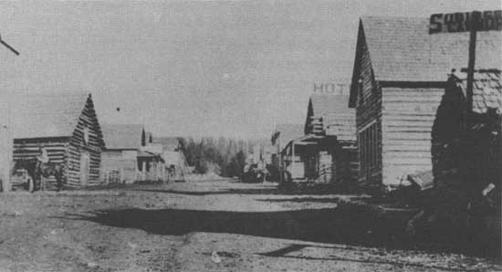
| Elk City, Idaho mining camp during the gold rush of the 1880's. |
Like most other rushes, more miners arrived in Alder Gulch than could be accommodated, so many ventured out in search of new bonanzas. One group, sometimes called the Four Georgians, first tried the Kootenai River area. After failing there, they drifted north, but still had no luck. Finally, in July 1864, they unearthed significant deposits at a place they appropriately named Last Chance Gulch. It ultimately became the most lucrative mining district in Montana aside from Alder Gulch, producing more than $19 million in gold over its first 4 years of operation. A lively mining camp named Helena emerged around the diggings and later became a commercial center and the capital of Montana. [32] A short time later, the third most important mining district in Montana was born. Late in the summer of 1864, prospectors struck pay dirt in the Big Belt Mountains east of Helena. A rush ensued in 1865 into what was named Confederate Gulch. Diamond City arose near the mines and, for a time, became perhaps Montana's most spectacular boomtown. [33]
The last major rush occurred in the Black Hills of western South Dakota. Rumors of gold finds in the area had abounded for years, but most prospectors chose to work other fields in the west of the State because the Dakota Sioux, who controlled the Black Hills by treaty, successfully kept most intruders out until about the mid-1870's. By that time, however, most rushes had ventured out and mines had come under the control of eastern venture capitalists, leaving little opportunity for the rainbow chasers. Thousands of prospectors thus turned to the Black Hills in hopes of realizing the dreams of riches that had so far eluded them. [34]
Finding it increasingly difficult to contain the miners and hoping to disprove rumors of gold, the military in 1874 send an expedition under General George A. Custer to investigate. The soldiers confirmed the presence of gold, and the invasion of prospectors intensified. Throughout the summer of 1875, troops removed violators, but more always moved in. Eventually, the military gave up trying to control the miners, and the Government, instead, removed the Sioux and tried to buy the Black Hills from them. By the fall, approximately 15,000 people had arrived, mostly concentrated in the French Creek area and in a new settlement named Custer City. Additional discoveries that winter sent many streaming north into Deadwood Gulch, where the West's most unrestrained frontier town, Deadwood, came to life in 1876. [35]
Although few people exploited them until at least a decade later, other metals such as silver, copper, lead, and zinc also were found frequently in the mountainous portions of the region. Silver appeared as early as 1862, but the first major discovery of silver-bearing quartz ledges was in the fall of 1863 by R.H. Wade in Idaho's Whiskey Gulch. The diggings proved substantial enough that Silver City soon emerged to serve mines in the War Eagle and Florida Mountains. [36] A second big silver lode was uncovered at Argenta, Montana, in 1864. Two years later, Samuel Hauser of Helena invested in the area's first smelter to process the silver ore. [37]
In subsequent years, mining in the region continued to grow and expand, and a wide variety of metals were found and used. The Phillipsburg, Montana, area, for example, witnessed the production not only of gold and silver, but also of lead and manganese in the Cable, Southern Cross, Black Pine, and Granite Mountain mines. A number of gold-silver-lead communities appeared; copper eventually provided the fortunes behind the famous wars among Montana's "Copper Kings" William Clark, Marcus Daley, and F. Augustus Heinz. [38]
Mining techniques, and mining's impact on the environment, changed over the years. Simple placer mining dominated gold diggings at first. Individually or in partnerships, prospectors worked streams for the small gold nuggets that had eroded down the mountainsides after veins containing the mineral had been exposed to the elements. Panning was the most basic method of extraction; scooping gravel and water from the streambed into a pan and shaking it were all that was required to separate the heavier gold. Other devices, such as cradles, rockers, long toms, and sluice boxes, operated on the same general principle; they could handle far more volume and were thus frequently used by teams of miners. [39]
When confronted with gold deposits in beds without running water, miners sometimes diverted streams or used hydraulic pumps to transfer water to where it was needed. Eventually, companies backed with eastern capital began investing in sophisticated equipment. In the most elaborate form of placer mining, for example, hydraulic pumps shot water through high pressure hoses at streambanks or hillsides. The earth-and-water mixture was then run through a complicated series of sluices to separate the gold. [40]
Other companies turned to even more complex forms of quartz mining. Veins of gold were sought out by sinking shafts into the mountainsides. Once found, the rich ore was extracted by breaking the auriferous vein out of its solid rock encasement. It was then crushed in stamp mills and the gold removed with quicksilver (mercury), which attracted the valuable mineral. Smelters later processed an even greater volume of gold bearing ore. [41]
Mining's impact on the region's environment intensified as methods became more complicated. Hydraulic pumping tore up gulches, stripped hillsides of vegetation, and flushed tons of sediment into streams. Quartz mining and the processes in mining and smelting silver and other metals resulted in mountains honeycombed with tunnels, high piles of tailings, and smoke-belching factories. [42]
The smelters of Butte and Anaconda brought problems along with prosperity. "In the late 1880s," the Montana Standard reminisced 100 years later, "smoke from seven Butte smelters showed that the copper mining business was doing well. But that same smoke also made it necessary for streetlights to be turned on at mid-day." In 1902, farmers in the Deer Lodge Valley noticed that their livestock were dying, and they blamed the Anaconda Company, which operated the mines and smelters. Court battles ensued, lasting until 1911, when the Anaconda Company won the final appeal in the circuit courts.
The company subsequently bought the lands of most of the surrounding ranchers and operated them as one gigantic ranch. Poisonous smelter emissions wiped out thousands of acres of timber and much of the vegetative cover. Although land exchanges and emission controls, as well as the closing of many of the mining operations in later years, eased environmental pollution, the Environmental Protection Agency and the Forest Service today are still concerned with rehabilitating the lands damaged around the turn of the 20th century. [43]
"Boasts about Butte's health and prosperity ignored the environmental atrocities," one author said of this period. "Sulfur, copper and arsenic fumes killed grass, flowers and trees; and cats who licked the grime off their whiskers risked arsenic poisoning." [44]
|
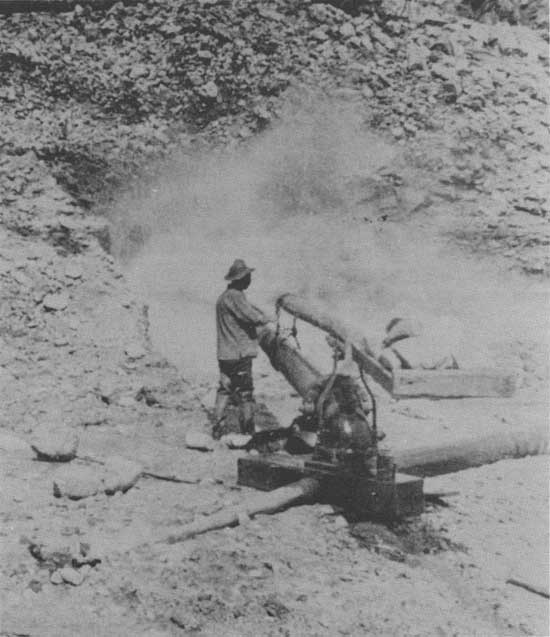
| Powerful pump used in hydraulic mining in Idaho during last decades of the 19th century. |
The Developing Regional Economy
Mining dramatically hastened the pace of the overall development within the region. While many mining camps became ghost towns, those that survived frequently evolved into cities that served the supply needs of surrounding diggings and communities. Lewiston became the headquarters for most mineral activity in northern Idaho. Boise and Idaho City emerged as major commercial and industrial centers in the Boise Basin. In Montana, Helena, Virginia City, and Butte came to fulfill a similar function. Mining, in effect, propelled parts of the region from a pre-agricultural economy into a commercial, urban economy almost overnight. [45] Perhaps most significantly, unlike the fur trade, mining fostered sizable population increases and consequential increases in demands for consumer goods, transportation, and timber resources—thus stimulating the development of a permanent economic infrastructure.
Ancillary industries and services were established to serve the needs of increasingly complex communities. Timber operations, for example, soon developed to meet the demand for mine shafts, fuel, and housing—and soon for railroad ties and trestles. Regional timber then expanded to supply the larger lumber markets of the East. [46] Many original prospectors were formerly merchants and in some cases loggers from the East. After failing to strike it rich searching for gold, some of them naturally returned to what they knew best. [47]
Many miners had been farmers; several quickly found they could make much more money by putting their old skills to use to take advantage of the typically exorbitant prices for scarce food commodities in remote and isolated mining camps. Farms and ranches usually began to dot the fertile valleys near mining areas not too long after the original gold strikes. [48] Cattle raising and staple crops such as grains and potatoes were most common at first; then fruit growing became popular in some areas, especially Idaho. [49]
The Road to Statehood
As populations expanded, efforts to give the Northern Region a political identity (statehood) intensified. In the Northwest Ordinance of 1787, Congress established procedures governing territorial expansion and the incorporation of new frontiers into the United States. Areas moved through a series of three phases as populations increased. At first, they enjoyed little self-rule and were administered largely by the Federal Government. The president, for example, appointed the territorial governor and the chief justice of the court system. Local governance increased at each step, until an area finally became eligible for statehood and thus received equal status within the Union. Upon reaching a population of 60,000, a territory could draw up a constitution and then petition Congress for acceptance into the Union. [50]
The process began for the western part of the region first, largely because of an earlier surge of settlement into the Willamette Valley of Oregon. Idaho and Montana were included in Oregon Territory, which Congress created in 1848. In 1853, the territory was split, with Idaho and western Montana becoming part of the new Washington Territory.
At the other end of the region, settlement had extended into the eastern Dakotas. Congress responded in 1861 by organizing Dakota Territory, which embraced not only the Dakotas, but also Montana and part of Idaho after they were removed from Washington Territory. [51]
Almost simultaneously, the mining rushes began attracting an almost instant population into the mountains of Idaho and Montana. Leaders in established communities within both Washington and Dakota Territories feared being politically outnumbered by miners and lobbied Congress in 1863 to create a new Idaho Territory (including Montana) out of the vast area between the two established territories. [52]
Idaho Territory was too large to govern from the start. Many of its miners were already moving east to the gold rushes in Montana. They concluded that the capital of Lewiston was too far away. They contacted Sidney Edgerton, a former Ohio congress man who had recently been appointed chief justice of Idaho Territory, to lead a campaign to carve Montana out as a distinct territory. [53]
Congress was willing to consider the idea, largely because the Idaho Territorial Legislature was lobbying for something similar—to split at the Continental Divide, with statehood granted to the western portion (to be called Jefferson in the proposal) and separate territorial status for the eastern portion. Edgerton's political muscle proved most effective. Idaho lost its bid for statehood, but Congress did designate a Montana Territory in 1864, with a western boundary of the Bitterroot Mountains, considerably west of the divide. [54]
For the next couple of decades, the region existed as a sort of colonial appendage of the United States. Politics revolved around a number of local interests and issues, but the lack of local control was clearly the overriding political concern. Residents resented that outsiders with little real interest or familiarity with the area were making most of the important decisions. Statehood, therefore, became a treasured political goal. [55]
Montana also launched a premature and ill-fated attempt at statehood in the 1860's. It was not until the 1880's, after further economic diversification and population growth, that campaigns with serious chances of success began. In 1883, the Montana Territorial Legislature called a special election to choose delegates to draft a constitution. The next year, voters approved the constitution and sent it to Congress for consideration. [56]
Dakota Territory undertook a similar effort at about the same time. In 1882, a group of Republicans from the southeastern corner of the territory formed the Dakota Citizen's League, which called for a convention the next year. Delegates met in Sioux Falls and drew up a constitution, revising it again 2 years later. Thus, by the mid-1880's, both Montana and Dakota Territories stood poised and ready for congressional action. National politics, however, would force them to wait a few more years. [57]
Democrats controlled the House of Representatives and the White House under President Grover Cleveland. They favored granting statehood to Montana Territory, because its population was seen as slightly Democratic, but they opposed the same for Republican-leaning Dakota. The Republicans held a majority in the Senate and, predictably, preferred just the opposite. The resulting stalemate was not broken until the next election. [58]
In 1888, the Republicans took the presidency with Benjamin Harrison and secured majorities in both houses of Congress. Knowing that it would be only a delaying tactic to oppose statehood, the "lame duck" Democratic majority in the House consented to advancing statehood for Dakota, Washington, and Montana. Montana was becoming increasingly Republican because of more migration from northern States after the Civil War. Democrats and Republicans also agreed to split the Dakota Territory into two States. Thus, on February 22, 1889, President Harrison signed an omnibus bill that, in effect, authorized and invited the four prospective States to submit constitutions. [59]
Idaho lagged behind in the statehood process, having spent much of the 1880's in turmoil over hostility toward its Mormon population and over moves in northern Idaho to secede and merge with Washington Territory. Finally, in 1890, Democratic Territorial Governor George L. Shoup organized a bipartisan constitutional convention. Voters overwhelmingly approved the results, and the Republican Congress quickly accepted the new, and safely Republican, State of Idaho into the Union. President Harrison made it official with his signature on July 3, 1890. [60]
The region was now fully incorporated into the United States. For the foreseeable future, American political institutions and attitudes toward resource development would govern the region and determine its fate. As these Northwest States entered the Union, Americans began to realize that the great frontier had ceased to exist. The minerals, timber, wildlife, waterways, and virgin lands that the frontier had always held in a seemingly unlimited supply were being rapidly depleted. This new consciousness impelled Congress to enact the Forest Reserve Act in 1891, the year after the admission of Montana, Idaho, and the Dakotas as States of the Union. Although they did not know it at the time, the Forest Reserve Act would affect the future of Northern Region citizens almost as much as would statehood.
Reference Notes
1. Angie Deho, A History of the Indians of the United States (Norman: University of Oklahoma Press, 1970), pp. 33-18; William Brandon, Indians (New York: American Heritage, 1985), pp. 20-21, 99.
2. Roderick Nash, Wilderness and the American Mind (New Haven, CT: Yale University Press, 1967), pp. 8-20.
3. William H. Goetzmann, Exploration and Empire: The Explorer and the Scientist in the Winning of the American West (New York: Vintage, 1966), pp. 10-13; F. Ross Peterson, Idaho: A Bicentennial History (New York: W.W. Norton, 1976), p. 33.
4. D.W. Meinig, The Great Columbia Plain: A Historical Geography, 1805-1910 (Seattle: University of Washington Press, 1968), p. 36; Michael P. Malone and Richard B. Roeder, Montana: A History of Two Centuries (Seattle: University of Washington Press, 1976), pp. 34-35.
5. Richard Edward Oglesby, Manuel Lisa and the Opening of the Missouri Fur Trade (Norman: University of Oklahoma Prewss, 1963), pp. 33-64, Burton Harris, John Colter: His Years in the Rockies (New York: Scribner's, 1952), pp. 85-101.
6. Oglesby, Manual Lisa, pp. 65-98; Hiram Martin Chittenden, The American Fur Trade of the Fur West: A History of Pioneer Trading Posts and Early Fur Companies of the Missouri Valley and Rocky Mountains and of the Overland Commerce With Santa Fe, Vol. I (New York; Rufus Rockwell Wilson, 1936), pp. 126-128.
7. Paul Chrisler Phillips, The Fur Trade, Vol. I (Norman: University of Oklahoma Press, 1961), pp. 390-395.
8. Richard M. Clokey, William H. Ashley: Enterprise and Politics in the Trans-Mississippi West (Norman: University of Oklahoma Press, 1980), pp. 62-63, 72-118.
9. Ibid., pp. 158-159, 169-171; Chittenden, pp. 262-270.
10. Phillips, Fur Trade, pp. 270-278.
11. Meinig, The Great Columbia Plain, pp. 61-62; Peterson, Idaho, pp. 37-38.
12. Meinig, The Great Columbia Plain, pp. 61-62; Peterson, Idaho, pp. 37-41.
13. Phillips, Fur Trade, pp. 410-414.
15. Chittenden, The American Fur Trade, pp. 329-330.
16. Clark C. Spence, Montana: A History (New York: W.W. Norton, 1978), pp. 17-18; Chittenden, The American Fur Trade, pp. 346-361.
17. Phillips, Fur Trade, pp. 421-429.
18. Paul C. Phillips, "The Fur Trade in Montana," in Michael P. Malone and Richard B. Roeder, eds., The Montana Past: An Anthology (Missoula: University of Montana Press, 1969), pp. 47-54; Earl Pomeroy, The Pacific Slope: A History of California, Oregon, Washington, Idaho, Utah and Nevada (New York: Knopf, 1966), p. 57, Peterson, Idaho, p. 47.
19. John E. sunder, The Fur Trade on the Upper Missouri, 1840-1865 (Norman: University of Oklahoma Press, 1965), pp. 11, 17; David J. Wishart, The Fur Trade of the American West, 1807-1840: A Geographical Synthesis (Lincoln: University of Nebraska Press, 1979), pp. 35-36, 66.
20. Merrill G. Burlingame, The Montana Frontier (Bozeman: Big Sky Books, Montana State University, 1942), pp. 72-74.
21. Peterson, Idaho, pp. 44-45.
22. Burlingame, The Montana Frontier, pp. 290-297.
23. Peterson, Idaho, pp. 48-54.
24. Pomeroy, The Pacific Slope, pp. 49-50.
25. Merrill G. Burlingame, "The Mining Frontier in Montana," in Malone and Roeder, eds., The Montana Past, pp. 63-65.
26. William S. Greever, The Bonanza West: The Story of the Western Mining Rushes, 1848-1900 (Norman: University of Oklahoma Press, 1963), pp. 257-260.
29. Robert G. Athearn, High Country Empire: The High Plains and Rockies (Lincoln: University of Nebraska Press, 1965), p. 85.
30. Burlingame, "The Mining Frontier in Montana," pp. 68-70.
33. Malone and Roeder, Montana, p. 52.
34. Bruce Nelson, Land of the Dakotas (Lincoln: University of Nebraska Press, 1961), pp. 140-14.4.
35. Watson Parker, Deadwood: The Golden Years (Lincoln: University of Nebraska Press, 1981), pp. 3-18; Rodman Wilson Paul, Mining frontiers of the Far West, 1848-1880 (New York: Holt, Rinehart and Winston, 1963), pp. 177-180.
36. Spence, Montana, p. 34; Greever, The Bonanza West, p. 271.
37. Burlingame, "The Mining Frontier in Montana," pp. 77-78.
39. Paul, Mining Frontiers, pp. 19-21.
40. Ibid., pp. 29-32; Malone and Roeder, Montana, pp. 54-55.
41. Burlingame, "The Mining frontier in Montana," pp. 76-77; Spence, Montana, p. 33.
42. Malone and Roeder, Montana, p. 55; Peterson, Idaho, p. 105.
43. "Air Quality Battles As Old As the State," Butte, Montana Standard (January 9, 1989); Letter, Bob Milodragovich for Region 1 History Review Committee to Henry C. Dethloff January 24, 1989.
45. Duane A. Smith, Rocky Mountain Mining Camps: The Urban Frontier (Bloomington: Indiana University Press, 1967), pp. 4-6; Peterson Idaho, p. 57; Pomeroy, The Pacific Slope, p. 53.
46. Athearn, High Country Empire, pp. 70-72; Spence, Montana, p. 33.
47. Smith, Rocky Mountain Mining Camps, pp. 126-127.
49. Robert E. Strahorn, The Resources of Montana and Attractions of Yellowstone Park (Helena: Montana Territorial Legislature, 179), p. 20; Robert E. Strahorn, The Resources and Attractions of Idaho Territory (Boise City: Idaho Territorial Legislature, 1881), p. 6.
50. Howard Roberts Lamar, Dakota Territory, 1861-1889: A Study of Frontier Polities (New Haven, CT: Yale University Press, 1956), pp. 1-8.
51. Oscar Osburn Winther, The Great Northwest: A History (New York: Knopf, 1950), pp. 163-164; Malone and Roeder, Montana, pp. 70-71.
52. Meinig, The Great Columbia Plain, pp. 238-239; Winther, The Great Northwest, p. 239.
53. Malone and Roeder, Montana, pp. 71-72.
55. Peterson, Idaho, pp. 91-92; Elwyn B. Robinson, History of North Dakota (Lincoln: University of Nebraska Press, 1966), pp. 199-200.
56. Malone and Roeder, Montana, p. 147.
57. Lamar, Dakota Territory, pp. 199-207.
58. Malone and Roeder, Montana, pp. 148-149.
59. Lamar, Dakota Territory, pp. 262-267.
60. Peterson, Idaho, pp. 93-97.
| <<< Previous | <<< Contents>>> | Next >>> |
|
history/chap2.htm Last Updated: 10-Sep-2008 |