|
The National Forests of the Northern Region Living Legacy— |
|
Chpaer 1
The Northern Rocky Mountains: The Land and People
Perhaps more so than in other parts of the United States, the Forest Service and forest resources permeate the lives of the people who live in the States served by the Northern Region—Montana, Idaho, North Dakota, South Dakota, and Wyoming. The Northern Region manages approximately 25 million acres of public lands in these five States. This land contains national forests and national grasslands in the northern Rocky Mountains and Great Plains, from the Idaho-Washington border eastward to the Dakotas and southward to central Idaho's Salmon River in the west and to the northwest corner of Wyoming in the east. [1]
The climate in the area varies in temperature; it is more severe in the eastern portion, where cold and dry continental air dominates. (Granite Peak, at 12,799 feet, in the Absaroka-Beartooth Wilderness of the Custer National Forest is the highest elevation in the Northern Rockies.) The western section enjoys somewhat milder temperatures because of the moderating influence of air from the Pacific Ocean. This eastern-western difference and the varying elevation and geology throughout the region result in a wide range of environments, ecosystems, and resources.
Long ago, geological forces pushed the Rocky Mountains upwards, giving the adjacent Great Plains a downward slant toward the east. The rivers draining from the Rocky Mountains into the Mississippi River subsequently deposited sediment onto the plains in a process known as aggradation. Over time, deep soils were formed. The rivers periodically changed course, slicing and cutting through the plains, until the terrain took on its present appearance of mostly flat land or rolling hills with occasional mesas, buttes, and badlands. [2]
The Rocky Mountains block moist air masses that flow from the Pacific Ocean toward the region. This forces most of the available precipitation to drop over the mountainous western portions, rather than over the plains to the east. Annual moisture totals in the plains stand at near-desert levels—about 10 inches annually— close to the foothills of the mountains, but the totals slowly rise toward the east—about 15 inches—in the western Dakotas. [3]
Some river valleys and small outcroppings of volcanic mountains in the plains have sufficient precipitation to support tree growth, but many areas do not. Most ecosystems on the plains are dominated by a variety of grasses that thrive under drier conditions. Plains grasses are divided into short (grama, buffalo) and tall (western wheat) types; the latter require more moisture. The more humid eastern edge of the plains lies in a transitional zone in which both short and tall grasses can be found. As precipitation levels fall off toward the west, however, the mixture gives way to predominantly short grasses. [4]
Harsh weather conditions on the plains ensure survival for only the most hardy forms of life. Strong winds, heat, drought, and fires ignited by thunderstorm lightning are constant summer threats; winters are typically long and cold, with occasional blizzards and subzero temperatures. As a result, the equilibrium of plant and animal life is frequently upset, and ecosystems experience wild swings in the cycles of death and regeneration. [5]
The mountainous portions of the Northern Region consist of rugged ranges, usually running on a north-south axis and broken by broad, flat valley floors and foothills. Peaks average 5,000 to 8,000 feet, with many 11,000 to 12,000 feet. Correspondingly, precipitation levels vary greatly, resulting in diverse vegetation and ecosystems. [6]
Conditions in the western mountains generally become more moist in higher altitudes and toward the west and northwest. In drier areas, grasslands and meadows rich in flowers and shrubs adjoin forests dominated by several types of pine trees, juniper, and Douglas-fir. Patches of aspen may appear in some places; occasional shrubs, such as snowberry or ninebark, may grow beneath the taller trees. The wetter forests support a greater variety of plant life, with such trees as spruce, cedar, larch, and hemlock and such shrubs or low trees as paper birch, Pacific yew, willow, mountain ash, thimbleberry, and huckleberry. The forest eventually thins near the timberline, and trees give way to an alpine ecosystem of grasses, sedges, and wildflowers. [7]
The Region's First Humans
The best archaeological evidence indicates that human use of the Northern Region began about 12,000 to 10,000 B.C.; however, archaeological data are more rare for this area than for other parts of the country, which in itself suggests late or little use by early humans. The first Native Americans in the area hunted now-extinct animals, such as mammoths, giant bison, and giant moose. Because winds blowing across the receding glaciers of the last ice age provided heavier precipitation, vegetation at that time was very lush, thus supporting the huge herds of big-game mammals that early nomadic predators followed. [8]
Between 5,000 to 4,000 B.C., a climate change brought drier conditions to the Northern Region, and many of the largest animals died out. As a result, a new type of prehistoric people evolved. Some evidence suggests that they may have migrated from the Southwest. Archaeological finds, such as grinding stones, pestles, and a variety of plant-processing tools, reveal the use of a greater diversity of the region's resources. A lifestyle developed that revolved around many plant products gathered from the forests, in addition to several types of smaller game animals. [9]
About 5,000 years later, yet another new group appeared—the direct ancestors of many of the groups that Europeans would later encounter in the region. Their lifestyle was similar to the people before them, except they eventually developed the bow and arrow and would increasingly rely on the bison. Improved technology allowed them to better exploit the hoofed resources that thrived on the region's nutritious grasses. [10]
These newest arrivals penetrated from the North and the Northwest into the region's western mountains. They developed a foraging lifestyle, relying on a wide range of available resources. Double lean-to long houses were made of wood and brush. The men hunted small game (and an occasional elk or bison), either individually or communally, and the women searched for berries, roots, nuts, and other edibles. [11]
Several important root crops were diet staples of all of the plateau cultures in the area. Bitterroot, for example, was ready for harvest sometime in May. The camas plant played an even more central role in the Native American economy. It grows in great abundance in mountain meadows with rich soils and beautifies the landscape in mid-summer with bluish-purple flowers. The Native Americans dug up the nutritious bulbs and prepared them in many different ways, drying many of them for long-term storage. [12]
The Kootenai
The first group to migrate into the region from the North was the Kootenai, who settled in the humid forests and rugged mountains of Montana and northern Idaho along the river that bears their name. Some scholars have argued that their language is distantly related to Algonkian. In addition to bitterroot and camas, the Kootenai gathered wild onions, huckleberries, blackberries, chokeberries, gooseberries, strawberries, and tree "moss" (actually lichens). In the spring, when tree sap was running, they sometimes stripped the bark off western yellow pine, western white pine, or quaking aspen to obtain the sweet, tender, edible inner layer—the cambium. [13]
The Kootenai were divided into subgroups, known as Upper and Lower (a reference to their location along the Kootenai River). Both fished for trout, whitefish, salmon, and sturgeon and hunted mountain sheep, bear, moose, elk, and deer. The Upper Kootenai incorporated aspects of plains culture into their lifestyle, traveling eastward into the grasslands every year to hunt bison. The Lower Kootenai were well known for their elaborate communal hunts of ducks, geese, and deer. [14]
The Salishan and Shaptin Peoples: The Kalispel, Coeur d'Alene, Nez Perce, and Flatheads
Two closely related Salish-speaking groups migrated into the area just south of the Kootenai. The Kalispel settled along the Pend Oreille River in Idaho and eastward into Montana, while the Coeur d'Alene occupied the Spokane River valley south of the Kalispel. Their subsistence patterns in many ways resembled the Kootenai, with the addition of a few local plants, such as thimbleberries, currants, and hazelnuts. Fish was an important source of protein for both groups, but only the Kalispel followed the salmon runs that supported so many Native Americans in the Columbia River basin. [15]
A Shaptin-speaking group, the Nez Perce, claimed the land below the Coeur d'Alene in what is now central Idaho. Their economic base was typical of Native American plateau cultures, although they also hunted bison periodically and possessed more plains culture than any other tribe west of the Continental Divide. The Nez Perce created their material needs directly out of local resources, fashioning clothes and furniture out of animal skins and using sheep horns for cups, bowls, and spoons. Women made wallets and bags out of Indian hemp, wove baskets out of cedar root, and prized elk's teeth as ornamentation. [16]
The easternmost of all the Salishan peoples were the Flatheads, whose name originated from the particular gesture used to indicate their name in local sign language. Before about 1600, the Flatheads lived in the Three Forks area in southwestern Montana, subsisting on roots, berries, fish, and small game for most of the year. Similar to their close allies, the Nez Perce, they incorporated aspects of plains culture into their economy and sometimes migrated as far east as the Big Horn Mountains in pursuit of bison. After the Shoshonis and, later, the Blackfeet moved into the area, however, the Flatheads retreated into the mountains and resided in the Bitterroot Valley of west-central Montana. [17]
The Flatheads continued to journey occasionally to the plains for bison until the mid-1800's, but the threat of enemies forced them to stay in the mountains more and rely increasingly on a foraging economy. In addition to the root gathering typical of neighboring groups, women dug sunflower roots and collected sunflower seeds. Men hunted deer and elk and trapped many smaller animals, including otter, lynx, marten, muskrat, and marmot. They also caught many fish using hooks made from bone. [18]
The Uto-Aztecan
Further south, beyond the Salishan peoples, three Uto-Aztecan-speaking groups dominated southern Idaho and southwest Montana. The Sheepeaters, or Mountain Snakes, for example, were Shoshonean people who preyed primarily on mountain sheep during the summer and descended into the milder valley of the Lemhi River or into smaller valleys nearby to spend the winter. Their isolated existence in remote high altitude areas made them among the most seldom-encountered groups by Europeans. [19]
The Snake River Shoshonis, or Snakes, and the Bannocks were originally distinct groups speaking different Uto-Aztecan dialects. After the early 1700's, they became closely linked and were usually found together. Their economy represented an adaptation of a plateau lifestyle to the drier climate in the northern fringes of the Great Basin. They shared some characteristics with their Salishan neighbors to the north. Camas roots, sunflower seeds, chokecherries, and serviceberries were important vegetable staples, along with deer, elk, antelope, and salmon for meat. [20]
The Snake River Shoshonis and the Bannocks relied less on larger game and more on smaller animals plentiful in their environment, including rabbits, prairie dogs, sage hens, groundhogs, and badgers. Snakes, lizards, grass-hoppers, mice, crickets, ants, and insect larvae also were occasionally eaten. They also took advantage of several plant food sources unique to the Great Basin, including yampa and a variety of grass seeds. Whites later referred to these peoples as "digger" Indians because they literally seemed to dig much of their food supply from desert hiding places. [21]
In the early 1600's, the Shoshonis began moving northeasterly across the mountains of Montana and onto the plains, where they slowly developed new patterns of resource use, concentrating more on bison, antelope, and elk. Sometime shortly before the turn of the next century, they acquired horses from the Utes to the south. Before long, the Shoshonis began trading horses to the Bannocks when that group turned to a lifestyle revolving around hunting bison on horseback. The two groups quickly moved further onto the plains and eventually dominated the area. Some Salishan tribes retreated further into the mountains, while others, such as the Flatheads and Kootenai, occasionally formed alliances with the Shoshonis and Bannocks and were able to continue using plains resources for awhile—at least until the Blackfeet arrived. [22]
The Changing Native American Culture
Shoshoni and Bannock rule on the northern plains was relatively short lived. By the early 1700's, many tribes had begun migrating onto the grasslands from the east. Former agricultural peoples and foragers were being driven out of the Upper Midwest by the ripple effect of the European fur trade to the east. Some tribes traded for guns and used them against enemies to dominate rich fur-producing areas in the West.
At the same time, the acquisition of horses and guns was enabling the Shoshonis and Bannocks to use plains resources on a more permanent basis. Previously, few groups actually lived on the plains. Most of those who traveled to the plains to hunt bison did so only temporarily, then returned to their homes in the Rocky Mountains or in the valleys of some of the tributaries of the Mississippi River. However, virtually all groups had horses by about the 1730's, which, with the gun, greatly improved their mobility and allowed them to hunt bison successfully on a year-round basis. [23]
In effect, improved technology and mobility allowed the development of a distinctive plains culture and economy based on modified forms of resource use. Native Americans lived in a symbiotic relationship with the huge herds of big-game animals. They occasionally set fire to the grasses on the plains, which encouraged the growth of new grasses on which bison, antelope, and elk thrived. Plains tribes extended some of their traditional woodlands lifestyle into the grasslands; they typically lived in timbered river valleys and ventured onto the plains to hunt. Bison were always favored when available, but deer, elk, antelope, bear, and mountain sheep also were pursued. [24]
Plains life supported a higher standard of living for most groups, including a certain level of surplus at times. Bison were most central to the plains economy. The meat was dried and sometimes mixed with dried berries to form pemmican, which could be stored for considerable lengths of time. Hide was used to cover lodges and to make everything from riding gear to weapons and containers. Bones were fashioned into tools, hair was used to make paint brushes, and sinew was turned into string or boiled into a type of glue. Women even powdered babies with pulverized bison dung. Smaller animals, such as beaver, mink, otter, wolves, and foxes, were trapped and their fur used for clothing, which was frequently ornamented with claws, teeth, or feathers. Most Native Americans on the plains did not engage in agriculture, but the women gathered plant products such as chokeberries, serviceberries, wild carrots, and wild turnips. These foods, however, were secondary in a diet otherwise dominated by meat. [25]
Native Americans lived in a symbiotic relationship with a huge herd of big-game animals. 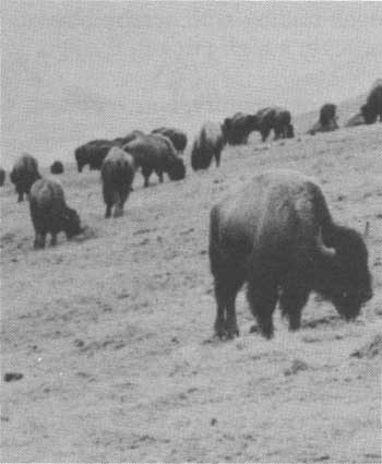
|
About four centuries before the emergence of the plains culture, a Siouan-speaking group known as the Mandan established a village on the Missouri River in what is now North Dakota. In a pattern typical of the time, the Mandans supplemented their corn production by hunting bison in a range westward to the eastern edges of what is now the Northern Region. Sometime in the early 1600's, they were joined by another Siouan-speaking tribe, the Hidatsa, who had broken away from the Dakota Sioux in northern Minnesota. A faction within the Hidatsa split before long and moved further west into south-central and southeastern Montana. This faction began to turn increasingly to the bison as a primary food source. Except for a period when they continued to grow corn in the Yellowstone River Valley, they adapted a plains lifestyle—especially after acquiring horses in the early 1700's. They would later be called the Crows and would further divide into two subgroups—the River Crows who lived north of the Yellowstone and the Mountain Crows who resided in the Absaroka and Big Horn ranges. [26]
Eventually, Upper Midwest tribes from the east who were being displaced by the European fur trade began to put pressure on the Crows. The Cheyennes, an Algonkian-speaking people from Minnesota, came first. By the early 1700's, the Cheyennes had migrated as far west as the Black Hills of eastern South Dakota, where they acquired horses and guns, turned to a plains lifestyle, and started ranging further west to hunt bison. [27]
Pushing the Cheyennes for a time, but later allied with them, were the powerful western divisions of the Dakotas, or Sioux, consisting of the Yanktons, the Yanktonais, and the Tetons. From the headwaters of the Mississippi, these Siouan-speaking peoples migrated southwesterly in retreat from their enemies, the Chippewas, who had acquired guns before them. By about 1775, the Dakotas had penetrated the grasslands, ridden on horseback gained access to guns of their own, and joined the emerging plains culture. [28]
The western Dakota continued moving in response to pressing white settlement. The Tetons eventually joined the Cheyennes, dominating as far as southeastern Montana. The Yankton and Yanktonais claimed the area just to the east in the Dakotas. A faction that had splintered off from the Yanktonais, the Assiniboines, migrated onto the plains of east-central Montana and ranged from the Missouri River in the south to Canada in the north. [29]
The European Entry Into the Region
At the same time, another wave of Algonkian-speaking groups was leaving homelands in Canada and becoming part of the plains culture in portions of what is now the Northern Region. The Piegans, one of the principal divisions of the Blackfeet, moved to the foothills of the Rocky Mountains in Montana and hunted at least as far south as the Three Forks area. Another group, the Atsinas (or Montana Gros Ventres), which had at one time been part of the Arapaho tribe, allied with the Blackfeet and lived just to the east of the Piegans and to the west of the Assiniboines. Together, the Blackfeet and the Atsinas played a major role in driving the Shoshonis from the plains of Montana. [30]
The same European expansionist pressures that had forced many Native Americans onto the plans would also eventually bring Europeans themselves into the Northern Region. Spain first directed Europe's attention toward America after Christopher Columbus' explorations at the end of the 15th century. Spaniards began forging an empire based in Central and South America; then they pushed northward through Mexico into what is now the Southwest United States. [31]
France did not lag far behind Spain in exploiting New World opportunities. The French set up colonies along the St. Lawrence River in the 1530's and quickly began trading with nearby Native Americans to obtain furs, which brought a high price in Europe.
England stepped in by the turn of the next century, concentrating most of its efforts along the Atlantic seaboard to the south of the French and in the Hudson Bay area to the north of the French. The English also established trade relations with Native Americans, and the two nations thus became rivals for the loyalties of various surrounding tribes. [32]
In 1670, England's Hudson Bay Company received a crown charter, which conferred exclusive rights to all fur-bearing animals on lands that drained into Hudson Bay. The company's success represented a challenge to French traders, who began moving westward and northward into the interior of Canada in an attempt to beat the English to virgin lands. The competition between the two countries, however, involved more than just the fur trade; both sides hoped to find the elusive Northwest Passage—the fabled water route allegedly linking the interior of the continent to the Pacific Ocean. The possessor of the passage supposedly would dominate the lucrative trade with the Orient for profitable luxury items such as spices, silk, and precious gems. [33]
The French sponsored expeditions into the West beginning in the late 1730's to investigate the potential for fur operations and to lay claim to the Northwest Passage. Led by Pierre Gaultier de Varennes (better known as the Sierur de La Verendrye), a retired soldier and fur trader, the first exploration set out from Lake Winnipeg in Canada but made it only as far as the Mandan villages. Unable to try again himself, La Verendrye sent his two sons, Francois and Louis-Joseph, on a second expedition in 1742. There is disagreement over how far the La Verendrye brothers traveled. The evidence is sketchy, but apparently they came within view of either the Big Horn Mountains or the Black Hills. They may have actually entered the Northern Region, or stopped just short of it. [34]
The rivalry between the two European superpowers eventually erupted into a series of conflicts referred to as the "Wars for Empire." The last in the sequence, the French and Indian War, ended in 1763 with the Treaty of Paris and confirmed British dominance in North America. France had to surrender almost all of its New World territories. Although now under English control, several French fur companies in southern Canada continued to compete with the Hudson Bay Company. In the 1780's, these companies combined to create the North West Company. The Hudson Bay Company and the North West Company pushed the British Canadian frontier further westward; by 1800, both were situated just north of what is now the Northern Region. [35]
Spain was by this time an empire in decline, but it made one last effort to compete for control of the northern territories. In 1762, Spain had acquired from France the land later known as the Louisiana Territory, including the portion of the Northern Region east of the Continental Divide, before France conceded its other North American territories to England in the Treaty of Paris. The Spanish also claimed the Pacific Northwest, including the portion of the Northern Region west of the Continental Divide, but so did England, Russia, and the United States. In 1792, Spain tried to establish a presence within the upper Missouri country (the eastern portion of the region) by hiring a French fur trader, Jacque D'Englise, to head an expedition into the area. He and his crew made it only to the Mandan villages before having to return with the bad news that the British were making inroads into the area. [36]
Spain responded to the British presence by forming the Missouri Company to win control of the fur trade in the upper Missouri country and thus ensure that profits from it would flow to Spain instead of Britain. But the Missouri Company encountered stiff resistance from tribes further south that desperately wanted to prevent Native Americans in the Northern Region from getting guns and trade goods. The Spanish retreated to their base in St. Louis shortly before 1800 and probably never ventured much beyond the Mandan villages. They may not have actually penetrated the region, but they brought back to European settlements some of the first reports of its geography, its native peoples, and its resources. [37]
The Lewis and Clark Expedition
In 1801, Thomas Jefferson became president. The United States by then had become a serious contender in the international competition for the control of the Northwest Territory. For many years, Jefferson had been interested in the West, both as an object of his scientific curiosity and as a likely outlet for his dreams of national expansion. He began planning an exploratory journey to the Pacific Ocean shortly after his inauguration. Because it was 2 years before the United States owned the Louisiana territory, Jefferson tried to keep the mission a secret to avoid trouble with Spain. He wanted to confirm U.S. claims to the Pacific Northwest and to investigate the presence of European rivals throughout the West. He also was interested in learning about resources, especially beaver populations. Beavers were quickly becoming the mainstay of the fur trade because of their fur's popularity among the more affluent Europeans. [38]
President Jefferson asked his private secretary and fellow Virginian, Meriwether Lewis, to lead the undertaking. Lewis agreed, but he insisted that William Clark, the youngest brother of the Revolutionary War hero George Rogers Clark, be appointed co-captain and share authority equally. Lewis, Clark, a regular crew of 30, and an auxiliary crew of 16 trained for the journey in the winter of 1803-4. By this time, American claims to the Pacific Northwest had been substantially improved by the Louisiana Purchase of 1803. Lewis and Clark departed from St. Louis in the spring of 1804, rowing, poling, and pulling a 50-foot keelboat and two smaller pirogues about 10 miles a day up the Missouri River. [39]
The explorers spent the first winter at the Mandan villages. When western Native Americans came to trade with the Mandans, Lewis and Clark questioned them carefully about the geography that lay ahead. They also spent considerable time trying to discourage warfare among the tribes in the upper Missouri country to ensure the peaceful passage of the vessels up and down the Missouri for the fur trade they hoped would follow. Toussaint Charbonneau of France was hired to serve as an interpreter to help deal with the Native Americans they would encounter. Charbonneau's Shoshoni wife, Sacajawea, later proved invaluable to the expedition as a guide and as a mediator with her people. [40]
When spring arrived, the auxiliary crew, having transported supplies only as far as the Mandan villages, floated the keelboat back to St. Louis. The rest headed upstream to complete the most difficult and unfamiliar part of the voyage. Within several weeks, the expedition reached the eastern edge of the Northern Region. In early June, Lewis and Clark noticed a major river entering the Missouri. They had arrived at the mouth of the Marias River; it was so full of spring runoff that it was difficult to determine which was the tributary and which was the Missouri. After several days of investigation, Lewis and Clark correctly chose the Missouri and thus avoided spending the winter in unfamiliar mountains. [41]
Continuing up the Missouri, the explorers eventually encountered Great Falls, where the city by that name now stands. It took a month of hard labor to portage around the falls before they finally entered the foothills of the Rocky Mountains. At this point, Lewis and Clark desperately hoped to find the Shoshonis to trade for horses to carry themselves and their cargo across the mountains. Near the end of July 1805, they came to the Three Forks area, where the Jefferson, Madison, and Gallatin Rivers join to create the Missouri. They then headed up the Jefferson, crossing the Continental Divide in mid-August. [42]
Once on the western side of the mountains, the party followed the Lemhi River downstream and finally located the Shoshonis. After a joyful reunion between Sacajawea and her family, Lewis and Clark obtained the needed horses. The Shoshonis directed the expedition northward into Montana's Bitterroot Valley. There they encountered cooperative Flatheads, who advised the expedition on how to get through the mountains ahead. The route suggested by the Flatheads followed the Bitterroot River to where Lolo Creek enters it and then crossed the rugged Bitterroot Mountains through Lolo Pass. [43]
The scarcity of game and the rush to beat the winter snows made this the most difficult stretch of the journey. The expedition reached the Clearwater River Valley in late September and met some friendly Nez Perce, who helped build boats for the remainder of the trip and kept the expedition's horses until its return. The explorers then floated down the Clearwater, into the Snake, and finally into the Columbia River, arriving at the Pacific coast in November 1805. [44]
The joyous crew built several cabins along the Columbia, a little inland from the ocean, and spent a long, wet winter. Near the end of March 1806, they headed home, retracing their original route to near the juncture of Lolo Creek and the Bitterroot River. Lewis and Clark then split their command to explore more of the upper Missouri country. Lewis and a small group went northward down the Bitterroot, crossed the mountains through Lewis and Clark Pass, and descended the Sun River to Great Falls. At that point, Lewis headed north with a few men to investigate the Marias River. But when two Blackfeet were killed in a brief skirmish over some stolen horses, the men quickly rushed back to the safety of the Missouri. [45]
Meanwhile, Clark continued to retrace the expedition's original route, back across the Continental Divide and into the Three Forks area. He sent 10 men down the Missouri to rendezvous with Lewis at Great Falls. The rest of that party crossed the Gallatin Valley and eventually entered the upper Yellowstone River through Bozeman Pass. They floated down the Yellowstone to where it enters the Missouri, where they awaited the arrival of the rest of the crew. The entire party was reunited in mid-August and arrived in St. Louis on September 23, 1806. [46]
The Historical Significance of the Expedition
The expedition route passed through what are now six Northern Region National Forests: the Lolo, Helena, Bitterroot, Beaverhead, Clearwater, and Nez Perce. The expedition was important to the development of the region for a number of reasons. It helped ensure American control of the entire area by confirming U.S. claims to the Pacific Northwest and by establishing relations with many powerful Native American tribes. The expedition also ended speculation about a Northwest Passage. As a result, Americans began to view the West as much more than an avenue to the Orient, and their attention focused on what seemed to be the endless potential for resource development. [47]
Lewis and Clark advertised the splendor and economic value of the lands they crossed. President Jefferson had instructed them to record their observations, and they filled more than a dozen notebooks with descriptions of everything from terrain to weather conditions to flora and fauna. They collected hundreds of plant and animal specimens, adding more than 200 species to the world's list of known types. Perhaps most important for the immediate future were the reports about beaver in the region. The expedition confirmed speculation that the area indeed had an ample supply, and traders wasted little time in taking advantage of the situation. [48]
While Lewis and Clark's work may have contributed to the region ultimately becoming American, in the short term it prodded the British into redoubling their own efforts to control the northwestern frontier. In the winter of 1804-05, for example, Lewis and Clark encountered a North West Company trader named Francois Larocque in the Mandan villages. Larocque tried to convince them to let him join the expedition to the Pacific, but Lewis and Clark were suspicious of any competition. Not wanting to be beaten by the upstart Americans, in 1805 the North West Company sent Larocque exploring into southeastern and south-central Montana. Starting out from the Assiniboine River in Canada, Larocque and his men crossed the Dakotas in a southwesterly direction until they reached the Yellowstone River. They continued upstream and investigated the Tongue and Big Horn drainages before heading home. Although Larocque returned with optimistic reports about an abundance of beaver in the area, the North West Company never followed through—at least not in that portion of the Northern Region. [49]
By the early 19th century the introduction of horses and guns by explorers had changed the native economy and society. Greater changes were on the horizon. Early explorers such as Lewis and Clark represented the cutting edge of an expansive culture with a much more advanced level of technology and a different set of attitudes and values about the physical environment and peoples' places within it. The Anglo-American culture would soon displace the traditional Native American methods of resource use and would dramatically change the relationship between humans and the environment.
By the end of the 19th century, mining, logging, cattle-raising, homesteading, railroads, and the appurtenances of modern American life transformed the wildernesses of the Northern Region into States of the Nation. The Forest reserves and then the national forests, under the management of the USDA Forest Service, were established to protect, preserve, and manage the forest resources of what would become the Northern Region. The purpose was to ensure that those resources continue to be used by humans as they had been for thousands of years.
Reference Notes
1. A small portion of Idaho's Kaniksu National Forest crosses into eastern Washington.
2. Walter Prescott Webb, The Great Plains (Boston: Ginn and Company, 1931), pp. 10-14; Herbert S. Schell, History of South Dakota (Lincoln: University of Nebraska Press, 1975), p. 6.
3. Schell, South Dakota, pp. 11-12; Elwyn B. Robinson, History of North Dakota (Lincoln: University of Nebraska Press, 1966), p. 8.
4. Robinson, North Dakota, pp. 8, 13; Michael R. Beckes and James D. Keyser, "The Prehistory of the Custer National Forest: An Overview," prepared for the USDA Forest Service, 1983, p. 13, historical files, Custer National Forest.
5. Webb, The Great Plains, pp. 31-46; Little Missouri National Grasslands, Custer National Forest, Environmental Statement: Management Plan, Rolling Prairie Unit, prepared for the USDA Forest Service, 1975, p. 5, in historical files, Custer National Forest.
6. C. Milo McLeod and Douglas Melton, The Prehistory of the Lolo and Bitterroot National Forests: An Overview (Missoula: USDA Forest Service, Region 1, 1986), pp. viii-5l.
7. Rick Reese, Rick Graetz, Stewart Aitchison, Dave Alt, and Wayne Phillips, "Montana's Mountain Ranges," Montana Magazine (1981), pp. 20-29.
8. McLeod and Melton, Lolo and Bitterroot: Overview, pp. v-1-v-2, v-7, and v-16; Beckes and Keyser, Prehistory of the Custer, pp. 84-85.
9. "Appendix J: Montana's Historical Legacy," in historical files A-O, Bitterroot National Forest, Hamilton, Montana; Beckes and Keyser, Prehistory of the Custer, pp. 84-85; William L. Bryan, Jr., Montana's Indians: Yesterday and Today (Helena: Montana Magazine, 1985), p. 9.
10. Bryan, Montana's Indians, pp. 9; Beckes and Keyser, Prehistory of the Custer, p. 89.
11. Bryan, Montana's Indians, pp. 9, 118; Alice Beck Kehoe, North American Indians: A Comprehensive Account (Englewood Cliffs, NJ: Prentice Hall, 1981), pp. 359-360.
12. Larry S. Thompson, Montana's Explorers: The Pioneer Naturalists (Helena: Montana Magazine, 1985), p. 27; Kehoe, North American Indians, pp. 359-360.
13. Harry Holbert Turney-High, Ethnography of the Kootenai (Menasha, WI: American Anthropological Association, 1941), pp. 8-12, 83-96; Olga Wedemeyer Johnson, Flathead and Kootenai: The Rivers, the Tribes, and the Region's Traders (Glendale, CA: Arthur H. Clark Company, 1969), pp. 72-74; Thain White, "Scarred Trees in Western Montana," in Montana State University Anthropology and Sociology Papers, No. 17 (Missoula: Montana State University, 1963), pp. 1-8.
14. Deward E. Walker, Jr., Indians of Idaho (Moscow: University of Idaho Press, 1978), pp. 37, 45.
15. Ibid., pp. 55-56, 59, 65; Robert C. Carriker, The Kalispel People (Phoenix: Indian Tribal Series, 1973), pp. 11, 14-15.
16. Herbert Joseph Spinden, "The Nez Perce Indians," Memoirs of the American Anthropological Association 2 (1908): 201-06; Francis Haines, The Nez Perce: Tribesmen of the Columbia Plateau (Norman: University of Oklahoma Press, 1955), pp. 2-14; Alvin M. Josephy, Jr., The Nez Perce Indians and the Opening of the Northwest (New Haven: Yale University Press, 1965), p. 16.
17. Michael P. Malone and Richard B. Roeder, Montana: A History of Two Centuries (Seattle: University of Washington Press, 1976), p. 11.
18. Ibid.; Harry Holbert Turney-High, The Flathead Indians of Montana (Menasha, WI: American Anthropological Association, 1937), pp. 111-121, 115, 123-124.
19. Virginia Cole Trenholm and Maurine Carly, The Shoshonis: Sentinels of the Rockies (Norman: University of Oklahoma Press, 1964), pp. 22-23; Kehoe, North American Indians, p. 354.
20. Brigham D. Madsen, The Northern Shoshoni (Caldwell, ID: Caxton Printers, 1980), pp. 18-19.
21. Robert H. Lowie, "The Northern Shoshoni," Anthropological Papers of the American Museum of Natural History 2 (1909): 184-185, 187.
22. George E. Hyde, Indians of the High Plains: From the Prehistoric Period to the Coming of Europeans (Norman: University of Oklahoma Press, 1959), pp. 121-122, 124, 126-127, 137; Kehoe, North American Indians, p. 277.
23. Hyde, Indians of the High Plains, pp. 136, 153; Arrell Morgan Gibson, The American Indian: Prehistory to the Present (Lexington, MA: D.C. Heath, 1980), pp. 242-243, 246.
24. Kehoe, North American Indians, pp. 271-273.
25. Robert H. Lowie, Indians of the Plains (New York: McGraw Hill, 1954), pp. 11-18.
26. Dale K. McGinnis and Floyd W. Sharrock, The Crow People (Phoenix: Indian Tribal Series, 1972), pp. 3-9, 21, 25; Robert H. Lowie, The Crow Indians (New York: Holt, Rinehart and Winston, 1935), pp. 72-89.
27. George Bird Grinnell, The Cheyenne Indians: Their History and Ways of Life, vol. 2 (New Haven: Yale University Press, 1923), pp.20-22, 30-31, 166-191; E. Adamson Hoebel, The Cheyennes: Indians of the Great Plains (New York: Holt, Rinehart and Winston, 1960), pp. 59-67.
28. Schell, History of South Dakota, pp. 19-20.
29. Royal B. Hassrick, The Sioux: Life and Customs of a Warrior Society (Norman: University of Oklahoma Press, 1964), pp. 11-19, 188-189; Edwin Thompson Denig, Five Indian Tribes of the Upper Missouri: Sioux, Arickaras, Assiniboines, Crees, Crows (Norman: University of Oklahoma Press, 1961), pp. 3-38, 63-71.
30. John C. Ewers, The Blackfeet: Raiders on the Northwestern Plains (Norman: University of Oklahoma Press, 1958), pp. 6-1l, 84-86; Malone and Roeder, Montana, pp. 17-18.
31. See Elizabeth A.H. John, Storms Brewed in Other Men's Worlds: The Confrontation of Indians, Spanish and French in the Southwest, 1540-795 (College Station, TX: Texas A&M University Press, 1976), p. 805.
32. William Brandon, Indians (New York: American Heritage, 1985), pp. 162-164, 185-187.
33. William H. Goetzmann, Exploration and Empire: The Explorer and the Scientist in the Winning of the American West (New York: Vintage Books, 1966), pp. 8-10.
34. Schell, History of South Dakota, pp. 26-30.
35. Malone and Roeder, Montana, pp. 20-21.
36. Robert G. Athearn, High Country Empire: The High Plains and Rockies (Lincoln: University of Nebraska Press, 1960), pp. 6-7.
37. Ibid., pp. 8-9; Schell, History of South Dakota,pp. 32-36.
38. Thompson, Montana's Explorers, pp. 6-7; Athearn, High Country Empire, pp. 12-14.
39. Goetzmann, Exploration and Empire, pp. 4-6; Schell, Montana, pp. 39-40.
40. Reuben Gold Thwaites, ed., Original Journals of the Lewis and Clark Expedition, 1804-1806, vol. I (New York: Antiquarian Press, 1959), p. 249; David Lavender, The Rockies (Lincoln: University of Nebraska Press, 1968), p. 42.
41. Thwaites, Original Journals, I, pp. 283-285 and II, pp. 113-126.
42. Ibid., II, pp. 178-229; Lavender, The Rockies, pp. 43-44.
43. James P. Ronda, Lewis and Clark Among the Indians (Lincoln: University of Nebraska Press, 1984), pp. 140-143, 153-158; Thwaites, Original Journals, III, pp. 27-28, 33-34, 45-106.
44. Ronda, Lewis and Clark, pp. 158-163; Thwaites, Original Journals, III, pp. 107-242.
45. Thwaites, Original Journals, III, pp. 243-63; IV, pp. 3-195; V, pp. 183-244.
47. Gerald Rawlings, The Pathfinders: The History of America's First Westerners (New York: Macmillan, 1964), pp. 47-48; Malone and Roeder, Montana, pp. 31-32.
48. Goetzmann, Exploration and Empire, pp. 3-4; Thompson, Montana's Explorers, p. 19.
49. David Lavender, Westward Vision: The Story of the Oregon Trail (New York: McGraw-Hill, 1963), p. 103; Malone and Roeder, Montana, p. 34.
| <<< Previous | <<< Contents>>> | Next >>> |
|
history/chap1.htm Last Updated: 10-Sep-2008 |