|
History of the Fremont National Forest
|
|
Chapter 1
Lake County Background
The Fremont National Forest, located in Lake and Klamath Counties in south-central Oregon, was named for Captain John C. Fremont, the Pathfinder, who was sent to explore this country in 1843.
Geography
This forest, on a high plateau and containing approximately 1,195,031 acres, is composed of two separate areas of the extreme eastern part of the Cascade Mountains. One area includes the Warner Mountains from Abert Rim to the California line. The other comprises the mountains between Lakeview and Beatty, bounded by the California line on the south, and the Deschutes National Forest on the north. The Fremont Forest practically marks the eastern limit of ponderosa pine in southeastern Oregon. Ninety percent of the total stand of timber is ponderosa pine. The remainder consists of white fir, lodgepole pine, incense-cedar, sugar pine, and juniper.
Major resources are water, timber forage for livestock and big game, recreation and wildlife. Approximately 72 percent of the Forest lies in Lake County and 28 percent in Klamath County. The elevation varies from 4200 feet to 8500 feet. Parts of the plateau rise to 6,000 and 7,000 feet, and in some places drop off abruptly in precipitous rimrock faces 2,000 to 3,000 feet. Chief among these prominences are Yamsey Mountain, Winter Ridge (known as Summer Lake Rim), Deadhorse Rim, Warner Mountains, and Abert Rim. Abert Rim is one of the highest and most definite exposed geologic faults in North America. It rises nearly 2,500 feet above the lake shore with a 640-foot vertical cliff of layer upon layer of lava at the top.
The Fremont Forest furnishes protection to the headwaters of the Williamson, Sprague, and Sycan Rivers. The Sycan flows into the Sprague, and the Sprague into Williamson, which in turn empties into Upper Klamath Lake. This water finally finds an outlet to the Pacific Ocean through the Klamath River.
The Chewaucan River, Drews Creek, Cottonwood Creek, and many other smaller streams on the east side of the mountains are within the northwestern extension of the Great Basin, and have no outlet to the sea. Many lake depressions are found on the east side.
Fremont streams furnish water directly or indirectly (underground) to seven communities and hundreds of farm families, including irrigation for 308,000 acres of farm land. Water and soil are the basic resources that enable the people living in the vicinity of the Fremont Forest to maintain a prosperous and pleasant livelihood.
Pleasing contrasts of scenery are afforded by mountains and lakes, timbered hills and desert wastes, gentle slopes and high rims.
Timber is the most valuable crop of the Fremont Forest. It is sold to mills in Lakeview, Klamath Falls, Bly, Paisley, Silver Lake, and Bend. Under the basic principle of sustained yield, the Forest is managed for continuous renewal of timber crops to replace those harvested. Accordingly, not more than 143 million board feet of timber, which is the estimated annual growth, are cut each year. The same principle of sustained yield applies to wildfire, forage for livestock, and other renewable resources.
The Fremont is one of the most important grazing forests in Region 6, annually furnishing forage for more than 34,700 cattle, 6,580 sheep, 30 horses, and several thousand mule deer. Careful management of grazing animals is required to insure maximum production of forage and to prevent accelerated soil erosion.
Recreation is furnished to over 70,000 persons each year who come to the Fremont to hunt, fish, ski, picnic, and camp. Hunters come from many places to hunt mule deer, waterfowl and upland game birds. Many improved campgrounds are available. Quite a number of interesting geological formations, Indian writings and historical points are found in or near the Forest.
Snake Indians and Early Explorers
This section of the State of Oregon was, before the coming of the white man, the home of the Indians. The natives who inhabited the lake country belonged to the Shoshone family, whose territory spread over southeastern Oregon, southern Idaho, and the whole of Utah and Nevada, extending into Arizona and New Mexico and the eastern border of California. This family has been divided by historians into two great nations: the Snakes (or Shoshones) and the Utahs.
John Work
One of the earliest expeditions by white men, of which we have record, was the trip through the present Lake County by John Work in October 1832. John Work was an explorer and fur trader for the Hudson's Bay Company. He tells of traveling near a chain of lakes, believed by Lewis A. McArthur of the Oregon Historical Society and Judge Robert Sawyer of Bend, to be the Warner Lakes. From these lakes, the party traveled west through the Rabbit Hills of Abert Lake. He tells of the party being attacked by small bands of Indians and the scarcity of water. Much of the route was stony which made the horses lame and tired. The weather was stormy most of the time. For food the party killed hares, ducks, and geese.
The party made one camp on a small creek believed to be Crooked Creek where Chandler Park is now. From this camp the men hunting food saw what they called Blacktail deer and gray sheep, but were unsuccessful in killing any. Some of the men found some wild plums, which were a major source of food for the local Indians. The plums were of a pretty good size, but the bushes were small. The Indians used the plum pits for beads. Work said the plums were the first fruit of this kind he had found in the Indian country. "C. Rondeau, L. Dondeau, J. LaRocque, and J. Rocquebin killed each a horse to eat. These men have been very improvident and did not husband their provisions with sufficient economy or they would not have had to kill horses yet."
Ewing Young
Ewing Young, in the fall of 1833, led a trapping company from the tributary streams of the Columbia River across Oregon to the upper end of the Sacramento Valley. The exact route taken is not known, but it is thought to have been by the way of Goose Lake and Pit River, the most practicable route.
Colonel J. J. Abert
In 1838, Colonel J. J. Abert, a United States engineer, prepared a map of the Oregon country in which Warner Lakes and other natural features of the present Lake County were shown. The data for this map, as credited by Colonel Abert, was obtained from Hudson's Bay explorers and trappers. Another map prepared from the same source was published in 1844 by M. Mofras, attache of the French Legation to Mexico. These maps showed a chain of four lakes in Warner Valley lying in the directions of northeast and southwest called by Mofras, "lacs des plants" — lakes of plants or vegetable growth, and according to Abert, connected by "plants river."
On Mofras' map is shown a trail called "Route des wagons des State Unis au Oullamet" — the United States wagon road to the Willamette — crossing the valley between the second and third of the "lacs des plants."
John C. Fremont
In December of 1843, John C. Fremont and his party traveled through Lake County while on his second exploring trip to the northwest coast. The party was on a trip through the unexplored regions between the Columbia River and California, and embracing the central basin of the continent between the Rocky Mountains and the Sierra Nevada. The party started from The Dalles on the Columbia River in November of 1843. Fremont reported on his proposed trip and actual trip as follows:
"This was our projected line of return — a great part of it absolutely new to geographical, botanical and geological science — and the subject of reports in relation to lakes, rivers, deserts, and savages hardly above the condition of mere wild animals, which inflamed desire to know what this terra incognita really contained. It was a serious enterprise, at the commencement of winter, to undertake the traverse of such a region, and with a party consisting only of twenty-five persons, and they of many nations — American, French, German, Canadian, Indian and colored — and most of them young, several being under twenty-one years of age. All knew that a strange country was to be explored, and dangers and hardships to be encountered; but no one blanched at the prospect. On the con:rary, courage and confidence animated the whole party. Cheerfulness, readiness, subordination, prompt obedience, characterized all; nor did any extremity of peril and privation, to which we were afterward exposed, ever belie, or derogate from, the fine spirit of this brave and generous commencement.
"December 16. We traveled this morning through snow about three feet deep, which being crusted, very much cut the feet of our animals. The mountain still gradually rose; we crossed several spring heads covered with quaking asp, otherwise it was all pine forest. The air was dark with falling snow, which everywhere weighed down the trees. The depths of the forests were profoundly still; and below, we scarcely felt a breath of the wind which whirled the snow through their branches. I found that it required some exertion of constancy to adhere steadily to one course through the woods, when we were uncertain how far the forest extended, or what lay beyond; and, on account of our animals, it would be bad to spend another night on the mountain. Toward noon the forest looked clear ahead, appearing suddenly to terminate; and beyond a certain point we could see no trees. Riding rapidly ahead to this spot, we found ourselves on the verge of a vertical and rock wall of the mountain. At our feet — more than a thousand feet below — we looked into a green prairie country, in which a beautiful lake, some twenty miles in length, was spread out along the foot of the mountains, its shores bordered with green grass. Just then the sun broke out among the clouds, and illuminated the country below, while around us the storm raged fiercely. Not a particle of ice was to be seen on the lake, or snow on its borders, and all was like summer or spring. The glow of the sun in the valley below brightened up our hearts with sudden pleasure, and we made the woods ring with joyful shouts to those behind; and gradually as each came up, he stopped to enjoy the unexpected scene. Shivering on snow three feet deep, and stiffening in a cold north wind, we exclaimed at once that the names of Summer Lake and Winter Ridge should be applied to these two places of such sudden and violent contrast.
"December 20. Traveling for a few hours down the stream this morning, we turned a point of the hill on our left, and came suddenly in sight of another and much larger lake, which along its eastern shore was closely bordered by the high, black ridge which walled it in by a precipitous face on this side. Throughout this region the face of the country is characterized by these precipices of black volcanic rock, generally enclosing the valleys of streams, and frequently terminating the hills. Often in the course of our journey we would be tempted to continue our road up the gentle ascent of a sloping hill, which at the summit would terminate abruptly in a black precipice, spread out over a length of 20 miles. The lake, when we first came in view, presented a handsome sheet of water; and I gave to it the name of Lake Abert in honor of the Chief of the Corps to which I belonged. The fresh water stream we had followed emptied into the lake by a little fall; and I was doubtful for a moment whether to go on or encamp at this place. The miry ground in the neighborhood of the lake did not allow us to examine the water conveniently, and being now on the borders of a desert country, we were moving cautiously.
"December 25. We were roused on Christmas morning by a discharge from the small arms howitzer, with which our people saluted the day; and the name of which we bestowed on the lake. It was the first time, perhaps, in this remote and desolate region, in which it had been commemorated. Always on days of religious or national commemoration our voyagers expect some unusual allowance; and, having nothing else, I gave to them each a little brandy, (which was carefully guarded as one of the most useful articles a traveler can carry,) with some coffee and sugar, which here, where every eatable was a luxury, was sufficient to make them a feast. The day was sunny and warm; and, resuming our journey, we crossed some slight dividing grounds into a similar basin, walled in on the right by a lofty mountain ridge. The plainly beaten trail still continued, and occasionally we passed camping grounds of the Indians, which indicated to me that we were on one of the great thoroughfares of the country. In the afternoon I attempted to travel in a more easterly direction; but, after a few more laborious miles, was beaten back into the basic by an impassable country. There were fresh Indian tracks about the valley, and last night a horse was stolen. We encamped on the valley bottom, where there was some cream-like water in ponds, colored by a clay soil, and frozen over. Chenopodiaceous shrubs constituted the growth, and made again our firewood. The animals were driven to the hill, where there was tolerable good grass.1
Captain William H. Warner
The next white men to visit this country was an exploring party under command of Captain William H. Warner, U. S. Topographical Engineer. He was accompanied by an escort of the Second Infantry commanded by Lt. Col. Casey. They started from Sacramento in August, 1849, and the purpose of the expedition was to locate a suitable emigrant and military road, and a railroad pass along the southern boundary line of Oregon.
Warner explored the country to the east and north of Goose Lake and spent several weeks in the Warner basin. In returning from Warner, on September 26 the party was ambushed by Indians killing Warner, Francis Bercier, the guide, and George Cover. A valley, lakes, and mountains were named for Captain Warner.
After the death of Captain Warner, Lieutenant R. S. Williamson was placed in command, who continued the work and reported in favor of the Pit River route.
Colonel C. S. Drew
The discovery of gold in eastern Oregon and Idaho in the early sixties and the consequent increased travel through this area was the reason for sending out some volunteer troops under Colonel C. S. Drew in 1864. Large numbers of miners were coming from the Willamette Valley, California, and other points, through Lake County to the gold fields of John Day, Powder River and Boise, Idaho. Several military forts were established along the route of travel from which to protect the settlers and to hunt down the Indians.
Colonel Drew escorted a party of miners from the present site of Chiloquin to Fort Boise in 1864. En route, he discovered the narrows between north and south Warner Valley. His route included the present site of Lakeview and the Jordan Valley, south and eastward from Lakeview. Drews Valley west of Lakeview was named for Colonel Drew.2
General Crook Establishes Camp Warner, 1866
During the early part of 1866, the Army under command of General George Crook, established a military camp on the eastern slope of Hart Mountain. This action was the result of numerous massacres and depredations by the Indians. The post was located in ponderosa pine timber in a well-sheltered basin at an altitude of about 6,500 feet and was known as Camp Warner.
On July 31, 1867 a new Camp Warner was located on Honey Creek in open-timbered country, about fifteen miles west of North Warner Basin and thirty-five miles north of the Oregon-California and Nevada state boundary line. The elevation was 500 feet lower than the first camp. The place was surrounded by mountains with only one outlet. It could have been approached from only one direction by an enemy, and then one rapid firing gun could have defended the place against a thousand warriors. A large spring of water flowed out of the side of the mountain near the fort and this furnished a small waterworks which supplied the soldiers with all the pure water that was needed. The mountains were covered with stately pines, and from this forest they secured timber to construct the government buildings and wood for the fort. A small sawmill was set up, and while some of the soldiers were fighting and scouting, others were engaged in logging, sawing and building.
The Honey Creek Camp was built on what is now Con Taylor land. Today, all buildings of the fort are gone, but foundation sites are easily discerned, and old square nails, parts of burned squared timbers, and other remains have been found. Portions of the old military road westward to Goose Lake Valley can be seen. Portions of the old road are shown on the General Land Office survey plats. The old military road to Fort Bidwell is outside the forest boundary.
First Settlers, 1867-70
A very few settlers came to the Goose Lake Valley in 1867 and 1868. After the Indian treaty of 1869, more arrived. Also, after the Civil War, many soldiers came west and settled in the valleys of Oregon, including Lake County.
In 1867, Joseph Ross settled in Goose Lake Valley on the California side of the line. When he arrived, some of the Indians were still hostile, so he was afraid to go into the woods to cut logs for a cabin. He therefore lived in a dug-out and because of this the Indians called him a "crazy paleface" and did not bother him.
In September of 1867, David R. Jones brought a load of grain to Camp Warner. He later took a homestead near Plush in Warner Valley, where he had many narrow escapes from the Indians. His daughter, [?]ce, was the first white child born in Warner on August 24, 1869. She married Warren Laird, Sr., of Plush.
In 1869, M. W. Bullard, a bachelor, settled near the head of the Goose Lake Valley on land described as Section 15, Township 39 South, Range 20 East, W.M. He donated this land upon which the town of Lakeview was later built. He built a log house, consisting of three rooms. One was used for a living room where he cooked, ate, and slept; the next room was used for a wood shed and storeroom; and, the other was used for a barn. The grade school in north Lakeview is named the Bullard School.
A. Snider came to Goose Lake Valley in 1868 and took a claim at Willow Ranch.
B. A store was started near the state line in 1869, but was unsuccessful due to the scattered population.
C. Hagerhorst came to Lake County about this time and was the first man to run sheep. He had a store at the present site of the Ned Sherlock ranch, which he sold to J. W. Howard.
Mrs. Henry Hammersly Newell came to Lake County from western Oregon in 1869 at the age of nine with her parents in the first wagon train. The eight families in the train were the first to settle here though several bachelors had arrived earlier. Families which arrived with this train were the Hammerslys, McCulleys, Tandys and Millers.
These immigrants had to ferry across Sprague River in boats owned by the Indians. When they arrived at Whiskey Creek, they found the Indians had a stockade and bridge across the creek. The Indians wanted $20 for allowing them to cross. Not feeling they could pay this amount, they went a short distance up the creek where they forded it. That night, after crossing Sprague River, a son was born to one of the Newell families. The next day they crossed the Devils Garden, one of the roughest spots in the country, on their way to Lakeview. One of the early arrivals, M. McShane, settled in Crooked Creek.
August Miller brought in a herd of cattle, being one of the first stockmen.
Joe Robnette built the first flour mill at New Pine Creek in about 1870.
Mrs. J. P. Duke (Minnie Myrtle), daughter of Mr. and Mrs. H. D. Myrtle, was one of the first children born in Lakeview. The Myrtles came to Lake County in 1869. They also had difficulty in crossing the Sprague River, but finally persuaded the Indians to let them cross.
John O'Neil was an early settler in Goose Lake Valley. When General Crook took charge of the military forces in this area, Mr. O'Neil came with him in charge of the pack train. He later settled near the state line in 1869.
Other settlers in Goose Lake Valley at this were A. Z. Hammersly, William Hammersly, T. Reed, William Tandy, Robert Tandy, Milton Brown, A. F. Snelling, H. M. Henderson, Sparks, Stone, Bogue, and Alexander Reed from the Willamette Valley.
Sawmills and Lumbering
As previously noted, the first lumbering in Lake County was done by the soldiers under General Crook after they had moved from the mountains east of the lakes to a point on Honey Creek in 1867. Jim McShane's brother, Joseph McShane, was the blacksmith for this operation which cut lumber to build the camp.
The first mill to furnish lumber for home building in Goose Lake Valley was cut by the Joseph Creek Mill, located about six miles southeast of the lower end of Goose Lake. This was a water mill with a capacity of about ten thousand feet daily. It was built by a Mr. Spaulging in about 1872. Lumber from this mill was taken as far north as New Pine Creek and also used for buildings in Alturas. A few years later, a small mill was built on Franklin Creek about four miles south of Davis Creek. This was known as a sash saw — a blade running up and down and cutting on the down stroke, driven by a sweep horsepower, and cut perhaps a thousand feet daily.
About 1874, Hyronymous and Russell built a water mill on Lassen Creek. This mill had a thirty-two foot overshot water wheel, and cut ten or twelve thousand feet daily.
E. W. Joseph, father of the late George W. Joseph, built a mill about 17 miles north of Lakeview at Mill Flat on the mountain road to Paisley in about 1875. This was a small steam-powered mill which had no planer. It was sold two or three years later to O. L. Stanley, who moved it in 1878 to a location on Camp Creek about a half mile below the summer home of George Stephenson. Lumber from this mill was brought into Lakeview for the earliest buildings here.
In about 1879, "Flintlock" Smith built a mill on Thomas Creek near the Hammersly place. It was run by a flutter wheel and was able to saw very little lumber.
Next was the J. M. Russell mill on Cottonwood Creek about three miles west of Cottonwood Dam, built in 1879. George Lynch helped build this mill. The first year, it was powered by two ten-horse power portable threshing machine engines. The second year, Russell put in a turbine water wheel. Seven men were employed in the mill and four in the woods.
In 1883, the Snelling brothers, Fuller and Vince, put a steam mill on the headwaters of Cox Creek about two miles south of the site of the E. W. Joseph mill. In 1885, this mill was moved to McShane Creek, a mile west of Crooked Creek.
On May 4, 1888, this mill burned from a sheep camp fire. It was rebuilt and acquired by Hawkins and Snelling, but burned again on August 6, 1889. It was then rebuilt near the Sam Dicks place in Crooked Creek. In 1906, it was moved to Camp Creek by the Lakeview Lumber Company, composed of Massingill, Bernard and Rinehart. This is where Clarence Rinehart received his first training in mechanics.
James T. Metzker built a steam mill at the 7-Up Ranch in 1888, and later moved it to Camas Prairie. His sons, Johnny and Clarence, hauled most of the lumber which was used for the buildings in Plush. Logging was done with bull teams.
Another mill was built by James K. Snyder in 1893 in the Camp Creek area. This mill was powered by a merry-go-round such as used for moving houses. Burt K. Snyder did his first work there, making the horse go and keeping the flies off the horse.
After helping fight the fire which burned the town of Lakeview on May 22, 1900, George Lynch was sent to the Hawkins and Snelling Mill to order lumber to rebuild the Bailey and Massingill store. He tried unsuccessfully to borrow a bicycle, so took one from the bicycle dealer. Since it had no light, he wired a lantern on it. He rode it as far as Warner Canyon where he borrowed a horse and went to the Hawkins and Snelling mill. He arrived there at 2:00 a.m. and ordered the lumber. He went to work at the mill and stayed for two years, working in both the mill and logging operations.
George Lynch came to Lake County and began working in mills in 1879. At one time, he owned a mill at Rosie Creek which burned after three years. He said the pay in the early years was $40 a month and board. The pay was not always in cash, but sometimes in pumpkins or other food. He said that more than two grades of lumber ("rough and clear surface") could be made in the early days, and that their planing mills could turn out any grade or type of lumber that was turned out in 1947. Mr. Lynch continued working in mills and woods until he was past 85.
Up to 1907, five small mills were operating in the county, the capacity of which in no instance exceeded 10,000 feet per day. The working season was about six months.
In 1910 and 1911, "Judge" Wilshire operated a waterpower sawmill at the edge of the forest on Cottonwood Creek. The mill could run about an hour and then had to shut down for water. One of the first to take out a timber sale on the forest, Wilshire on July 1, 1911, bought 25,000 feet (B.F.) of Western yellow pine and 14,000 feet of sugar pine. He was given until July 11, 1912, to complete the contract. Bill Harvey drove a six-horse team with a jerk line and hauled the lumber to Lakeview. Wilshire also had a large band of sheep in the Cougar Peak area.3
Gold Mining
In 1871-72, great interest was taken in prospecting and mining by the settlers. Two mining districts were formed: Campbell's on the west and north sides of Goose Lake, and the Goose Lake district east of the lake. Many claims were staked out but gold was not found in quantities to warrant large expenditures.4
First Post Offices
The first post office in Goose Lake Valley was opened at Willow Ranch in 1869, where A. Snider had taken a homestead and opened a store in 1868.
In 1873, a post office was established at the A. Tenbrook ranch several miles south of Lakeview. Mr. C. Hagerhorst, who came to Lakeview in 1870, was one of the first to run sheep. He started a store at the present site of the Ned Sherlock ranch, and the post office was moved into his store. In 1877, J. W. Howard, an Englishman and father of Harry Howard of Lakeview, bought the store from Mr. Hagerhorst and moved it to Lakeview. One of the first couples to be married in Lakeview was J. W. Howard and Eva Hubbard, who were married at the Tenbrook Hotel in 1877.
Post offices were established at Silver Lake and Summer Lake on December 9, 1875.
The post office was established in Lakeview in late 1876. The New Pine Creek Post Office was started December 8, 1876, with S. A. Hammersly as Postmaster.
The first steamboat on Goose Lake was built by Wheeler and Tom Little in 1883 for a pleasure boat and to transport flour and fruit from New Pine Creek to the west side. Whenever the boat ventured to the north end of the lake, it would go aground because of the shallow water.
Lake County Created in October, 1874
Lake County was originally a part of Wasco County, which included all country east of the Cascades into Wyoming. In the 1860s, the area which is now most of Lake County was taken from Wasco and added to Jackson County with the seat in Jacksonville.
The settlers of Goose Lake Valley were from 200 to 300 miles from their county seat at Jacksonville. Since the trip had to be made over very rough country of mountains, lakes, and poor roads, the people decided they needed a new county. The settlers wanted the county named Crook in honor of General Crook, the Indian fighter. However, the bill was introduced and passed in the Oregon legislature in 1874 with the name as Lake County. At that time, Lake County included what is now Klamath County. The legislature created Klamath County from the western part of Lake County in 1882. In 1885, the Warner Valley area, formerly in Grant County, was added to Lake County.
Lynching
On August 20, 1894, a lynching occurred in Lakeview in front of the courthouse. W. S. Thompson was a desperado who lived in Warner Valley. The day before the lynching he smashed his wife's nose, broke three of her ribs, slashed his wife's saddle horse to death and ripped open the abdomens of several other horses.
While Frank Lane, Lake County Sheriff, was out of town, a group of citizens headed by Joe Morrow took the jail keys away from Al Heminger, Deputy Sheriff, got Thompson out of jail, and hanged him from the courthouse porch. The coroner's jury found that he came to his death from strangulation by unknown parties.
After the jury was dismissed, a Warner Valley citizen asked Mr. M. Barry, a member of the jury, what the verdict was. After being informed, the Warner man said, "Then I guess I'll go and get my rope."
Some time later, Mr. Al Heminger, who felt some responsibility for the occurrence of the lynching, committed suicide.
Lake County Prospers, 1899
During 1899, Lake County enjoyed the most prosperous year in its history. The sale and shipment of about 35,000 head of cattle brought nearly $1,000,000 into the county. On 75,000 head of sheep driven to market, $225,000 more was added to the Lake County stockmen's income. One million, five hundred thousand pounds of wool were sheared and shipped, bring the sheepmen $195,000. In addition to the sales of cattle, sheep, and wool, 1,500-2,000 heads of horses and mules were sold, valued from $25,000 to $40,000. Also, 1,000-1,500 hogs for $90,000 and 2,500 goats for $7,500 were sold making a total of $1,460,000 received from stock.
The sawmills of the county were not able to supply the demand for lumber, notwithstanding that they turned out over 1,250,000 feet valued at $20,000. The number of buildings erected was nearly double the number of any former year.
Lakeview Burned, 1900
On May 22, 1900, the town of Lakeview was almost completely destroyed by fire. The loss was estimated at $250,000. All but two of the business houses were burned, causing a loss of about $250,000. Sixty-four buildings were destroyed, many of them stores carrying large stocks of merchandise. Two entire blocks in the main business section were destroyed, as well as the greater portions of six other adjoining blocks. No lives were lost. The residents went to work putting up new buildings and by October, the town boasted fifteen brick buildings with three more under construction.
On November 23, 1902, another fire occurred with a loss of about $11,100.
Warner Valley Land Case
By action of the 1860 Congress, all swamp lands within the State of Oregon were granted to the State. In 1870, the Oregon legislature authorized its citizens to buy this swamp land. However, very little of the land of eastern Oregon had been surveyed, and the character of the land was not of record. Therefore, a great controversy arose as to whether the lands in question were swamp lands on March 12, 1860, the date Congress passed the bill.
This controversy, which lasted 25 years, was carried on between the Warner Valley Stock Company, a corporation, and the settlers in Warner Valley, for the ownership of 4,000 to 5,000 acres of land. Several families settled on these lands, cultivated them, and made their homes there. However, their failure to obtain title to the lands on account of the dispute with the Warner Valley Stock Company, was very detrimental to the county. Because of this, immigration to this valley was greatly retarded, and some settlers who attempted to build homes were forced to abandon them. "It caused a valley, by nature intended for the small farmer and stock raiser, to be the range ground for a large stock company. It left a section of the county, capable of supporting a large population, but sparsely settled. It does not take the decision of a court to show which would be the better condition for Lake County and its inhabitants."
The case was tried in local courts and taken to the Oregon State Supreme Court. The decision finally handed down gave the settlers, who had been able to stay, the lands they had filed on. In later years, some of the ranchers obtained grazing permits on the national forest.
Forest Reserves
In 1892, President Benjamin Harrison, by Congressional Act of 1891, created the first forest reserve — the Yellowstone National Park Timberland Reserve — in Wyoming. During his term, he set aside forest reservations totaling 13,000,000 acres. The Act of 1891, however, failed to provide for the protection and administration of the reserves, and the forestry movement was loudly charged with "locking up" from use the forest resources of the country.
President Grover Cleveland in 1897 added 21,000,000 acres to the Forest Reserve System. The act of June 4, 1897, clearly defined the purposes of the reservations. These were "to improve and protect the forest within the reservation, or for the purpose of securing favorable conditions of water flows, and to furnish a continuous supply of timber for the use and necessities of citizens of the United States."
All reserves were in the West. The task of placing them under administration was large and complicated. Many Western interests, especially stockmen, bitterly opposed every step on the part of the government. The forest reserves were placed under the Department of Interior, which had no foresters. The Division of Forests in the Department of Agriculture under Dr. Bernard E. Furnow, a trained forester from Prussia, was a small unit of less than a dozen men in the Department of Agriculture, with no administrative authority over the forest reserves. The result was a makeshift administration that called forth public criticism and ridicule.
In 1898, Gifford Pinchot, the first native American to obtain professional training in forestry, succeeded Dr. Fernow as head of the Division of Forestry. With great energy and leadership, he enlarged the scope of the Division's activities, increasing it during the next seven years from a personnel of eleven to over eight hundred men, many of whom were graduates of the new forestry schools at Biltmore, Cornell, and Yale. Under his leadership, the Division became a bureau in 1901.
When Theodore Roosevelt became President in 1901, he brought new enthusiasm to the whole conservation movement. Through his influence, Congress passed an act on February 1, 1905, transferring the forest reserves to the Department of Agriculture. On July 1, 1907, the Bureau of Forestry became the Forest Service and the resources were given the official designation of National Forests.
The Act passed on February 1, 1905, opened the way to the greatest achievement in American Conservation and did four things:
1. opened natural resources of the forest to legitimate use,
2. placed the Federal forests under the foresters,
3. stabilized, for all time, the principle of reserving for public purposes the Federally-owned forest lands, and
4. marked the beginning of American forestry on a broad scale.
On February 1, 1905, the Secretary of Agriculture, James Wilson, wrote Gifford Pinchot, Chief Forester:
"In the administration of the forest reserves it must be clearly borne in mind that all land is to be devoted to the most productive use for the permanent good of the whole people and not for the temporary benefit of individuals or companies. . .Where conflicting interests must be reconciled, the question will always be decided from the standpoint of THE GREATEST GOOD OF THE GREATEST NUMBER IN THE LONG RUN."
This policy has been practiced by the Forest Service ever since.
Funds for Administration
In the early days of the forest reserves, Congress appropriated very little money for administration, and none for development and protection of the forests. The timber, forage, water, scenery, recreation and wildlife could not be used because there were no roads, and the timber was being destroyed by fire because of lack of equipment and men. Gradually, Congress has appropriated money for these purposes. Roads, trails, telephone lines, and ranger stations have been built. Range watering places have been developed, as well as public campgrounds and summer homesites.
Forest Ranges and Range Wars
From the early days in the West, cattle and sheep were grazed on mountain ranges in the summer and returned to the lower country for winter. This custom was well-established before the first forest reserve. Since the public domain was open and free to grazing, the numbers of livestock increased by leaps and bounds. Soon the range became overstocked and overgrazed, and conditions became desperate. Conflicts over choice forage became common; range wars followed, with loss of human life and livestock, especially sheep, for the cowman openly opposed the coming of the sheep on the range.
The organized sheep shooting started in some of the central Oregon counties and lasted from 1896 to 1906. One of the worst range wars occurred in northern Lake County on the desert east of Silver Lake in the vicinity of Christmas Valley. One of the largest slaughters of sheep at one time was on the evening of February 3, 1904, when about 2,200 sheep belonging the Benham brothers were killed by unknown persons. Five masked men rode up to the herder, Phil P. Barry, tied his hands and placed a sack over his face. Then they started to work killing the sheep with knives, clubs and guns, which required all night. A few sheep escaped the men but were later killed by coyotes. By the time the herder had walked to Silver Lake and notified the authorities at Lakeview, three days had elapsed. No trace could be found of the men and no information could be obtained. Several persons received warnings to keep quiet, in the form of letters mailed from distant points. One morning a merchant at Silver Lake found a rope tied to his door with a note advising him not to talk.
Later, J. C. Conn, a merchant at Silver Lake, lost a valuable string of freight wagons by fire. Mr. Conn was reluctant to say much about it, though he suspected that he was being punished for giving out some information about the sheep killing.
On March 4, 1904, J. C. Conn walked out of his store and was not seen alive again. A search of the entire country was made for him. The creek, which was high at the time, was dragged for several miles. About six weeks later, a buckaroo found his body about a mile from Silver Lake, lying face up, arms outstretched. Mr. Conn's revolver was by his side. He had two bullet wounds in his chest and one in his back. One bullet passed through his body and was found a few inches underground. The coroner's jury came to the conclusion that Mr. Conn died from self-inflicted wounds, though it was believed that he was murdered.
On April 29, 1904, another band of sheep was killed on the desert near Silver Lake. Out of a band of 2,700 head, 300 or 400 were all that could be found. This killing was handled in the same way as the first one. Several rewards were offered for the conviction of the sheep killers and for the murderer of J. C. Conn, but no arrests were made.
In 1902, 30% of the sheep died on the desert because they were too poor when winter began. The ranges were quite heavily stocked with local sheep and every year many thousands of mutton sheep were brought in from the sheep district of Crook and other counties. These sheep were herded all summer under the pretext of driving them to market. There was no regulation of any kind and all the herders were each chasing after some favorite "camp." It was common to find three to six bands of sheep meeting at well-known camps. Of course, only one band could stay and then the others would have to look for a new place. These meetings commonly caused "mix-ups," damaged the bands considerably, destroyed much feed, and caused useless traveling to some corral to separate the bands.
From the foregoing information, it can be seen that some government regulations of the ranges was badly needed. The cattlemen and sheepmen who owned range property and who had a prior right to use the range were in favor of government administration of the ranges.
The Oregon Journal of Portland, Oregon, in its Sunday edition of July 25, 1948, carried a story by Elsie King entitled "Oregon's Bloodiest War," telling of the many disputes between the cattlemen and sheepmen, and of killings and quoted excerpts from a letter to the Portland Oregonian, dated December 29, 1904, signed "Corresponding Secretary, Crook County Sheepshooting Association of Eastern Oregon," which in part reads:5
"Our annual report shows that we have slaughtered between 8,000 and 10,000 head during the last shooting season and we expect to increase this respectable showing during the next season provided the sheep hold out and the governor and the Oregonian observe the customary laws of neutrality."
But the growing feeling that there was need of supervision and allotment of grazing rights inclined many stockmen favorable and as more and more were becoming informed of the purpose of the national government, the opposition melted away.
Proposed Goose Lake Forest Reserve
Filibert Roth, who was sent out from Washington in 1903 to investigate the proposed Goose Lake Forest Reserve, included the following in his report:
"Sentiment: Sentiment with regard to Forest Reserve is all that could be desired. With the exception of some of the newspapers which have been making money by advertising the timber and other land claims (a very lucrative business during the last two years), a few range hogs, and the numerous timber claim locaters, there is no one who was consulted in the matter but was in favor of a reserve.
"Recommendations: It is recommended that the Goose Lake Forest Reserve be created at once, that the necessary patrol be provided as soon as practicable (even if but one man can be spared)."
The nearest railroad at this time was the northern terminus of the narrow gauge Nevada-California-Oregon at Madeline, California, 100 miles south.
Cattle owned in the vicinity of the lands recommended for withdrawal were as follows. Counting only those who possessed 25 head or more, there were 64 owners with about 17,000 head of cattle, of whom:
| 6 owned over 1,000 head | |
| 2 owned over 300 to 1,000 head | |
| 10 owned | 100 to 300 head |
| 20 owned | 50 to 100 head |
| 25 owned | 25 to 50 head |
Since the cattle had to be fed in winter, most cattlemen owned meadow and farm lands where feed was prepared for winter use.
The sheep encroached on the open cattle range, and therefore the cattlemen had to acquire and fence their lands, both summer pasture in the mountains, and meadow lands on their ranches.
Establishment of Goose Lake and Fremont Forest Reserves
The Goose Lake Forest Reserve was established August 21, 1906, and extended from the Warner Mountains north of the California line, and the area surrounding Dog Lake north to a line between the Klamath Indian Reservation and the town of Paisley. The Fremont Forest Reserve was established September 17, 1906, by proclamation signed by President Theodore Roosevelt (34 Stat. 3226, U.S. Statutes at Large, 59th Congress, 1905-1907, Vol. 34, Part 3, pages 323202). It extended from that line north along the Indian Reservation, thence west to the summit of the Cascade range, thence north to a point northwest of Crescent, thence east, including the timber line south and east of the Paulina Mountains, thence following the timber line south to the point of beginning. It included the territory north of the Goose Lake Forest Reserve extending from Paisley almost to Bend. At this time, the area of the Goose Lake Reserve was 630,000 acres, and the Fremont 1,235,720 acres. The forests were put under administration February 1, 1907, by Executive Order No. 817.
On July 1, 1908, parts of the Fremont were transferred to the Deschutes and Umpqua, and the Fremont and Goose Lake Forests were combined, and given the name of Fremont. This name was selected for the combined forest by Gilbert D. Brown, because of the fact that Captain John C. Fremont had explored the greater part of this territory.
An act of Congress on March 4, 1907, 34 Stat. 1269, provided that "The Forest Reserves shall hereafter be known as National Forests."
Later Boundary Changes
On July 1, 1911, the Paulina National Forest was created out of the southern part of the Deschutes, the northern part of the Fremont, and parts of the Cascade, Crater, and Umpqua Forests, covering an area of 473,124 acres.
On March 15, 1912, the Yamsey Mountain addition containing approximately 92,000 acres was added to the Fremont National Forest. This area included Townships 29 and 30 South, Ranges 12 and 13E., W.M., and also the strip of National Forest land on the west side of Silver Creek in Townships 29 and 30, Range 14E., W.M. This land was taken from the Paulina Forest and gave the Fremont a total of 944,000 acres.
At this time, the Fremont had approximately 1,000 miles of exterior boundaries, and about 670 miles of interior boundaries. This entailed a considerable amount of work since the boundaries up to this time were posted with cloth signs, which had to be replaced frequently. During the summer of 1912, the metal boundary signs were brought into use.
Paulina Discontinued
On July 1, 1915, the short-lived Paulina Forest, under W. W. Cryder, Forest Supervisor, was discontinued. Parts of it were added to the three parent forest — Fremont, Deschutes, and Crater — and part eliminated from National Forest and restored to homestead entry.
Silver Lake Addition
On May 14, 1930, 224,291 acres, known as the Silver Lake Addition, were included within the Forest boundary in the northern part of the Forest by Congress, Public Law 214. This changed the total gross area from 935,714 to 1,160,005 acres, and the net areas from 849,286 to 975,015 acres. By Presidential Proclamation 2143, dated October 14, 1935, (49 Stat. 3486) 566,588 acres gross, and 67,026 acres net were added to the Fremont National Forest. After other minor changes the totals were:
| Gross | 1,767,396 |
| Alienated | 623,663 |
| Net | 1,143,733 |
On February 12, 1942, President Roosevelt signed two executive orders, No. 9060 (7 FR 1059) adding 21,235 acres of timber land to the Fremont, and No. 9061 (7 FR 1060) transferring 15,673 acres of grazing land from the Fremont National Forest to the Department of Interior to be administered by the Grazing Service. Most of the eliminated and acquired land lies in the vicinities of Silver Lake and Paisley, and along the eastern boundary of the Warner District. As a result of the above executive orders, the acreage of the Fremont was then:
| Gross | 1,772,637 |
| Alienated | 520,357 |
| Net | 1,252,280 |
In addition to the above major changes, several other eliminations, additions, and numerous land exchanges have changed the acreage many times.
Klamath Indian Termination Act
On July 1, 1961, as a result of the Klamath Termination Act for the Klamath Indian Reservation, 525,700 acres of former Indian Reservation lands were placed under National Forest administration. A new National Forest, called the Winema, (named for the heroine of the Modoc War — Woman of the Brave Heart) composed of the former Indian lands and parts of the Rogue River, Deschutes, and Fremont was created.
By this change in boundaries, the Fremont lost to its western neighbor, the Winema, 144,000 acres, which included the western part of the Silver Lake District lying in Klamath County. In return, the Fremont received several large and scattered areas of about 96,000 acres on the west side of the Bly and Paisley Districts, some of which are bounded by the Winema. The net loss to the Fremont was about 37,300 acres. The 1963 acreage figures for the Fremont were as follows:
| Lake County 61% | Klamath County 29% | Total | |
| Forest | 835,846 | 354,532 | 1,208,378 |
| Private | 327,651 | 182,273 | 509,924 |
| Totals | 1,181,497 | 536,805 | 1,718,302 |
The allowable cut on the 144,000 acres removed from the Silver Lake District in Klamath County was 5,000,000 board feet annually, while the allowable cut on the 96,000 acres added to the Bly District is about 14,000,000 board feet annually. This will result in Lake County's receiving more lieu-of-tax funds from timber receipts than in the past. Lake County's share of receipts in 1961 was $405,007, but under the new plan the shares would be around 519,300. The reason for this is that the Fremont will have a larger annual allowable cut, and a larger percentage of the Fremont lands will be in Lake County than before, hence a larger percentage of the timber revenues.
Due to more recent boundary changes, the Forest now contains 1,105,031 acres, with approximately 7,270 of the Forest in Lake County and 2,870 in Klamath County.
NOTES
1. Bach quotes Fremont from F. A. Shaver, A. P. Rose, R. F. Steele, and A. E. Adams. An Illustrated History of Central Oregon. Spokane, WA. Western Historical. 1905. pp 806-808.
2. Bach continues to follow Shaver, et. al., here and below. pp 808-827.
3. Bach's information here comes from interviews with George Lynch, George Stephenson, and Lynn Cronemiller.
4. Bach quotes and paraphrases this and the material below from Shaver, et. al.
5. The author of the outrageous letters to the Oregonian has been identified as Roscoe Knox, a Lake County wit.Sketches about the Deschutes Country, Portland: Oregon Historical Society, 1981.
|
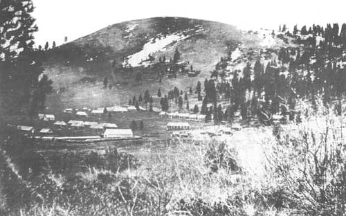
| Fort Warner on Honey Creek. The Fort was moved to Honey Creek during the summer of 1867. (U.S. Signal Corps photo #111-SC-83561, National Archives.) |
| <<< Previous | <<< Contents>>> | Next >>> |
|
fremont/history/chap1.htm Last Updated: 01-Feb-2012 |