|
Heceta House: A History and Architectural Survey |
|
SECTION TWO: GROUNDS, ARCHITECTURE, AND ALTERATIONS
II. ALTERATIONS TO LANDSCAPE
Alterations were made to the station almost as soon as it was completed. In 1895, a land slide behind the tower made it necessary to cut back the slope to prevent further sliding.
A flag pole was erected between the houses in 1914, and, in 1916, major changes were made which effected the appearance of both houses and grounds. The outhouses were razed; a sewer system consisting of a pipe over the bluff was installed; and the picket fence surrounding the house was changed to wire and post.
There is no record explaining why the original fence was replaced. Picket may have required too much maintenance, and wire was much in vogue at the time.
Approximately 1923, the wooden boardwalk to the lighthouse was replaced by a concrete sidewalk with a pipe handrail. The wooden walkways around the houses also were changed.
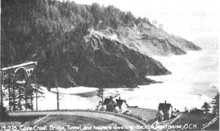
In 1930, preparations began for construction of the Heceta Head-Cape Creek section of the Roosevelt Highway.
Completion of the highway changed the nature of life on the coast, and it changed the Heceta Head station as well.
One site map shows the highway running through the station, taking the barn in its course. However, this map is inaccurate. It is true that the highway originally swung closer to the station, but the photograph below, taken between 1934 and 1939, shows that it still missed the barn site by a good distance.
A landslide that occurred in 1961 removed a chunk of road above the garage. The highway had to be moved 75 to 100 feet to the east, according to one of the workers who repaired it.1
1John Gunter, Oregon State Highways employee, telephone interview held November 19, 1979.
The confusion over the fate of the barn may have resulted from the fact that the barn was razed in 1932, the same year the highway was completed. Once the road was finished, the keepers may have decided they had no further use for the barn. The ease of driving to Florence for dairy products made the raising of cows unnecessary and automobiles had replaced horses long before the road was built.
The switch from horse and wagon transportation to the automobile also signalled the decline of the wagon road below the keepers' quarters. A dirt road in front of the houses was established for automobile use.
|
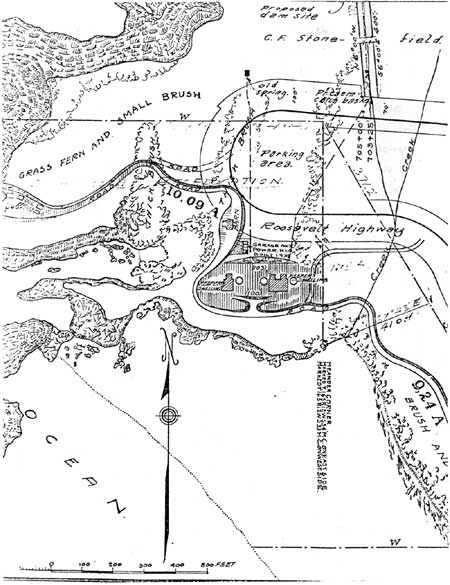
| Portion of Lighthouse Service site map shows highway going through Heceta Head Station. Also note the location of water systems. (click on image for a PDF version) |
In 1934, the Lighthouse Service purchased roughly one-third of an acre for construction of a new water system. The Stonefields sold the land for $50. The purchase price included the right to lay an underground pipeline to the station. Location of the site is listed on the preceding map as "proposed dam site."
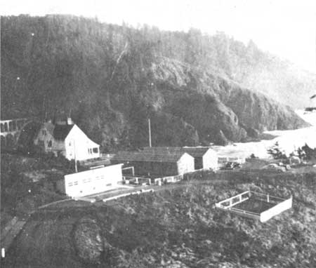
The 1930's were a decade for change at Heceta Head. As mentioned in the previous section, electric power reached the station in 1934. A combination garage-power house was built behind the single dwelling that year. The garage still stands, though it is used only for storage.
In 1939, the rear wings of the duplex were removed and, approximately 1940, the single house was razed. Reduction of personnel due to the installation of electric power lines remains the best explanation for razing the house.
The 1940's also brought great changes to the station, though the alterations were of a temporary nature.
When Coast Guard troops began arriving in early 1943, two barracks were erected on the site of the former keeper's dwelling; the north barrack was the mess hall, and the south was the living quarter.
It is interesting to note that sanitation measures did not improve on the 1916 "pipe over the bluff" system. During the war, the sewage of 75 men was piped over the bluff, just as it had been in previous years.
A lookout tower was built above the lighthouse. A Coast Guard inventory sheet lists the cost of the lookout as $75. Stanley Anderson, the cook stationed at Heceta Head during the war, says the 'tower' was little more than a small shelter that provided scant protection for the unfortunate on duty.
In addition to the other buildings, two sentry houses were built, one at the entrance to the driveway and another at the end of the driveway. Dog houses were erected on the hillside beside the duplex, and a fenced training area for the dogs was established at the location of the former chicken yard.
A few items at the station often are attributed to Coast Guard military personnel, but evidence does not support this belief.
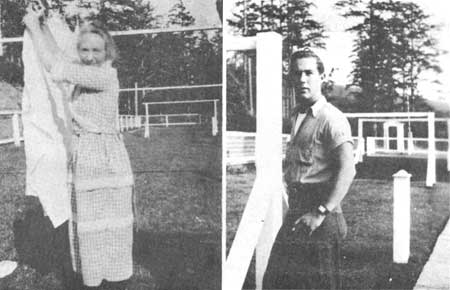
One of these is the short, wood post behind the duplex. It is imbedded in cement, and presently serves as a bird feeder.
Early residents conclude that the post was put up by the Coast Guard. However, a photograph of Mrs. DeRoy, circa 1920, distinctly shows the Coast Guard post.
|
| Mrs. DeRoy and unidentified member of the Coast Guard pose near post. Note the sentry station in the photograph on the right. |
It is possible that the post was once part of a "call bell" system installed in 1895. The Annual Reports of the Lighthouse Board for that year state, ". . .electric call-bell wires were set up and wires strung."2 This theory is supported in part by the Hansen sisters, who remember an early telephone system that connected the keepers' houses with the tower. They claim the system never worked properly.
2Annual Reports of the Lighthouse Board. 1895, as listed in Record Group No. 26, National Archives.
The post lines up exactly with the tower, so it is quite possible that some lines could have reached from the post to the lighthouse.
If it is true that the communications system did not work, the wires may have been removed by early keepers. The solitary post therefore would not have been noticed or even recognized by later residents.
Two cables located on the trail to the beach also pose a mystery. It has been suggested that they were part of an underground communications system which connected wartime military posts along the coast, but, according the a Coast Guard inventory sheet, the telephone was the only communications system then in existence.
The barracks may have remained standing as late as 1950. However, a few white parking bumpers are the only evidence remaining today of the Heceta Head military base.
In recent years, few changes have been made to the grounds, though the duplex has undergone some remodelling. Nevertheless, the appearance of the site has altered considerably.
The fence that once marked the boundary of the wagon road has disappeared, and, for a time, the road disappeared under heavy brush. State Parks personnel rebuilt part of the trail in 1963, and Forest Service workers later extended the path. The trail now corresponds with the route of the old wagon road.
The fence that marked the boundary between government and Stonefield property has deteriorated, although some cedar posts still are standing.
However, the most dramatic changes have occurred as a result of the growth of vegetation. Salal and blackberry bushes have filled in the hillside once devoted to gardens and dog shelters, and the Sheep Hill that provided excellent grazing land has surrendered to Sitka spruce.
The growth of the trees had the effect of placing a barrier between the house and tower, so the sense of a combined light station is lost. With the hill overgrown, it is hard to imagine that keepers could once easily monitor the beacon from their homes.
| <<< Previous | <<< Contents>>> | Next >>> |
region/6/siuslaw/heceta_house/sec2-2.htm
Last Updated: 04-Aug-2008