|
History of The Willamette National Forest
|
|
APPENDICES (continued)
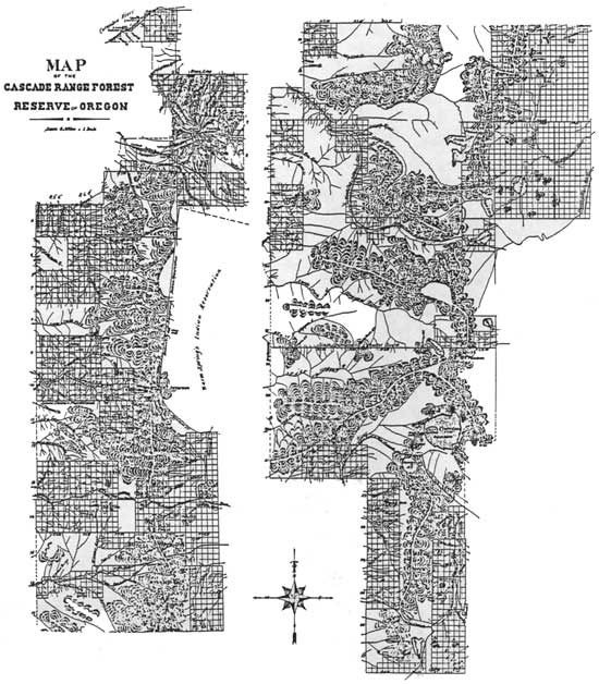
(THE CASCADE RANGE FOREST RESERVE.)
BY THE PRESIDENT OF THE UNITED STATES OF AMERICA.
A PROCLAMATION.
Whereas, it is provided by section twenty-four of the Act of Congress, approved March third, eighteen hundred and ninety-one, entitled, "An act to repeal timber-culture laws, and for other purposes," "That the President of the United States may, from time to time, set apart and reserve, in any State or Territory having public land bearing forests, in any part of the public lands wholly or in part covered with timber or undergrowth, whether of commercial value or not, as public reservations, and the President shall, by public proclamation, declare the establishment of such reservations and the limits thereof;"
And Whereas, the public lands in the State of Oregon, within the limits herein after described, are in part covered with timber, and it appears that the public good would be promoted by setting apart and reserving said lands as a public reservation.
Now, Therefore, I, GROVER CLEVELAND, President of the United States, by virtue of the power in me vested by section twenty-four of the aforesaid Act of Congress, do hereby make known and proclaim that there is hereby reserved from entry or settlement and set apart as a Public Reservation, all those certain tracts, pieces or parcels of land lying and being situate in the State of Oregon, and particularly described as follows, to-wit:
Beginning at the meander corner at the intersection of the range line between Ranges six (6) and seven (7) East, Township two (2) North, Willamette Meridian, Oregon, with the mean high-water-mark on the south bank of the Columbia River in said State; thence northeasterly along said mean high-water-mark to its intersection with the township line between Townships two (2) and three (3) North; thence easterly along said township line to the north-east corner of Township two (2) North, Range eight (8) East; thence southerly along the range line between Ranges eight (8) and nine (9) East, to the south-west corner of Township two (2) North, Range nine (9) East; thence westerly along the township line between Townships one (1) and two (2) North, to the north-west corner of Township one (1) North, Range nine (9) East; thence southerly along the range line between Ranges eight (8) and nine (9) East, to the south-west corner of Township one (1) North, Range nine (9) East; thence easterly along the Base Line to the north-east corner of Township one (1) South, Range ten (10) East; thence southerly along the range line between Ranges ten (10) and eleven (11) East, to the south-east corner of Township four (4) South, Range ten (10) East; thence westerly along the township line between Townships four (4) and five (5) South, to the south-west corner of Township four (4) South, Range nine (9) East; thence southerly along the west boundary of Township five (5) South, Range nine (9) East, to its intersection with the west boundary of the Warm Springs Indian Reservation; thence southwesterly along said Indian reservation boundary to the south-west corner of said reservation; thence south-easterly along the south boundary of said Indian reservation to a point on the north line of section three (3), Township twelve (12) South, Range nine (9) East, where said boundary crosses time township line between Townships eleven (11) and twelve (12) South, Range nine (9) East; thence easterly to the north-east corner of Township twelve (12) South, Range nine (9) East; thence southerly along the range line between Ranges nine (9) and ten (10) East, to the south-east corner of Township thirteen (13) South, Range nine (9) East; thence westerly along the Third (3rd) Standard Parallel South, to the north-east corner of Township fourteen (14) South, Range nine (9) East; thence southerly along the range line between Ranges nine (9) and ten (10) East, to the south-east corner of Township fifteen (15) South, Range nine (9) East; thence easterly along the Third (3rd) Standard Parallel South, to the north-east corner of Township sixteen (16) South, Range nine (9) East; thence southerly along the range line between Ranges nine (9) and ten (10) East, to the south-east corner of Township twenty (20) South, Range nine (9) East; thence easterly along the Fourth (4th) Standard Parallel South, to the north-east corner of Township twenty-one (21) South, Range nine (9) East; thence southerly along the range line between Ranges nine (9) and ten (10) East, to the south-east corner of Township twenty-three (23) South, Range nine (9) East; thence westerly along the township line between Townships twenty-three (23) and twenty-four (24) South, to the south-east corner of Township twenty-three (23) South, Range six (6) East; thence southerly along the range line between Ranges six (6) and seven (7) East, to the south-west corner of Township twenty-five (25) South, Range seven (7) East; thence westerly along the Fifth (5th) Standard Parallel South, to the point for the north-west corner of Township twenty-six (26) South, Range seven (7) East; thence southerly along the surveyed and unsurveyed west boundaries of Townships twenty-six (26), twenty-seven (27), twenty-eight (28), twenty-nine (29) and thirty (30) South, to the south-west corner of Township thirty (30) South, Range seven (7) East; thence westerly along the unsurveyed Sixth (6th) Standard Parallel South, to the point for the north-west corner of Township thirty-one (31) South, Range seven and one-half (7-1/2) East; thence southerly along the surveyed and unsurveyed west boundaries of Townships thirty-one (31), thirty-two (32) and thirty-three (33) South, Range seven and one-half (7-1/2) East, to the south-west corner of Township thirty-three (33) South, Range seven and one-half (7-1/2) East; thence easterly along the township line between Townships thirty-three (33) and thirty-four (34) South, to the north-east corner of Township thirty-four (34) South, Range six (6) East; thence southerly along the east boundaries of Townships thirty-four (34) and thirty-five (35) South, Range six (6) East, to the point of intersection of the east boundary of Township thirty-five (35) South, Range six (6) East, with the west shore of Upper Klamath Lake; thence along said shore of said lake to its intersection with the range line between Ranges six (6) and seven (7) East, in Township thirty-six (36) South; thence southerly along the range line between Ranges six (6) and seven (7) East, to the south-east corner of Township thirty-seven (37) South, Range six (6) East; thence westerly along the township line between Townships thirty-seven (37) and thirty-eight (38) South, to the south-west corner of Township thirty-seven (37) South, Range four (4) East; thence northerly along the range line between Ranges three (3) and four (4) East, to the north-west corner of Township thirty-six (36) South, Range four (4) East; thence easterly along the Eighth (8th) Standard Parallel South, to the south-west corner of Township thirty-five (35) South, Range four (4) East; thence northerly along the range line between Ranges three (3) and four (4) East, to the south-west corner of Township thirty-one (31) South, Range four (4) East; thence westerly along the township line between Townships thirty-one (31) and thirty-two (32) South, to the south-west corner of Township thirty-one (31) South, Range one (1) East; thence northerly along the surveyed and unsurveyed Willamette Meridian to the north-west corner of Township twenty (20) South, Range one (1) East; thence easterly along the township line between Townships nineteen (19) and twenty (20) South, to the north-east corner of Township twenty (20) South, Range one (1) East; thence northerly along the range line between Ranges one (1) and two (2) East, to the north-west corner of Township eighteen (18) South, Range two (2) East; thence easterly along the township line between Townships seventeen (17) and eighteen (18) South, to the south-east corner of Township seventeen (17) South, Range two (2) East; thence northerly along the range line between Ranges two (2) and three (3) East, to the south-west corner of Township seventeen (17) South, Range three (3) East; thence easterly along the surveyed and unsurveyed township line between Townships seventeen (17) and eighteen (18) South, to the point for the south-east corner of Township seventeen (17) South, Range four (4) East; thence northerly along the surveyed and unsurveyed range line between Ranges four (4) and five (5) East, subject to the proper easterly or westerly offsets on the Third (3rd) Second (2nd) and First (1st) Standard Parallels South, to the north-west corner of Township five (5) South, Range five (5) East; thence easterly along the township line between Townships four (4) and five (5) South, to the southeast corner of Township four (4) South, Range six (6) East; thence northerly along the range line between Ranges six (6) and seven (7) East, to the north-west corner of Township four (4) South, Range seven (7) East; thence easterly along the township line between Townships three (3) and four (4) South, to the southwest corner of Section thirty-four (34), Township three (3) South, Range seven (7) East; thence northerly along the surveyed and unsurveyed section line between Sections thirty-three (33) and thirty-four (34), twenty-seven (27) and twenty-eight (28), twenty-one (21) and twenty-two (22), fifteen (15) and sixteen (16), nine (9) and ten (10) and three (3) and four (4), to the north-west corner of Section three (3) of said Township and Range; thence easterly along the surveyed and unsurveyed township line between Townships two (2) and three (3) South, to the point for the south-east corner of Township two (2) South, Range eight (8) East; thence northerly along the unsurveyed range line between Ranges eight (8) and nine (9) East, to the south-east corner of Township one (1) South, Range eight (8) East; thence westerly along the township line between Townships one (1) and two (2) South, to the south-east corner of Section thirty-four (34), Township one (1) South, Range eight (8) East; thence northerly along the section line between Sections thirty-four (34) and thirty-five (35), twenty-six (26) and twenty-seven (27), and twenty-two (22) and twenty-three (23) to the north-east corner of Section twenty-two (22); thence westerly along the section line between Sections fifteen (15) and twenty-two (22) to the south-east corner of Section sixteen (16); thence northerly on the section line between Sections fifteen (15) and sixteen (16) to the point for the north-east corner of Section sixteen (16); thence westerly along the section line between Sections nine (9) and sixteen (16) to the southeast corner of Section eight (8); thence northerly along the section line between Sections eight (8) and nine (9) and four (4) and five (5) to the north-west corner of Section four (4), Township one (1) South, Range eight (8) East; thence easterly along the Base Line to the south-east corner of Section thirty-three (33), Township one (1) North, Range eight (8) East; thence along the unsurveyed section lines northerly to the point for the north-east corner of Section thirty-three (33), westerly to the point for the north-east corner of Section thirty-two (32), northerly to the point for the north-east corner of Section eight (8), westerly to the point for the south-west corner of Section six (6); thence northerly along the unsurveyed range line between Ranges seven (7) and eight (8) East, to the point for the northwest corner of Township one (1) North, Range eight (8) East; thence westerly along the unsurveyed township lines between Townships one (1) and two (2) North, to the north-west corner of Township one (1) North, Range seven (7) East; thence northerly along the surveyed and unsurveyed range line between Ranges six (6) and seven (7) East, to the mean der corner at its intersection with the mean high-water-mark on the south bank of the Columbia River, the place of beginning.
Excepting from the force and effect of this proclamation all lands which may have been, prior to the date hereof, embraced in any legal entry or covered by any lawful filing duly of record in the proper United States Land Office, or upon which any valid settlement has been made pursuant to law, and the statutory period within which to make entry or filing of record has not expired; and all mining claims duly located and held according to the laws of the United States and rules and regulations not in conflict therewith;
Provided that this exception shall not continue to apply to any particular tract of land unless the entryman, settler or claimant continues to comply with the law under which the entry, filing, settlement or location was made.
Warning is hereby expressly given to all persons not to enter or make settlement upon the tract of land reserved by this proclamation.
In witness whereof, I have hereunto set my hand and caused the seal of the United States to be affixed.
| [SEAL.] |
DONE at the City of Washington, this twenty eighth day of September, in the year of our Lord, one thousand, eight hundred and ninety-three, and of the Independence of the United States the one hundred and eighteenth.
GROVER CLEVELAND.
BY THE PRESIDENT:
ALVEY A. ADEE,
Acting Secretary of State.
THE CASCADE RANGE FOREST RESERVE.
(SECOND PROCLAMATION.)
BY THE PRESIDENT OF THE UNITED STATES OF AMERICA.
A PROCLAMATION.
WHEREAS, The Cascade Range Forest Reserve, in the State of Oregon, was established by proclamation dated September 28, 1893, under and by virtue of section twenty-four of the Act of Congress, approved March third, eighteen hundred and ninety-one, entitled, "An act to repeal timber-culture laws, and for other purposes", which provides, "That the President of the United States may, from time to time, set apart and reserve, in any State or Territory having public lands wholly or in part covered with timber or undergrowth, whether of commercial value or not, as public reservations, and the President shall, by public proclamation, declare the establishment of such reservations and the limits thereof"
And whereas, it is further provided by the Act of Congress, approved June fourth, eighteen hundred and ninety-seven, entitled, "An act making appropriations for sundry civil expenses of the Government for the fiscal year ending June thirtieth, eighteen hundred and ninety-eight, and for other purposes", that "The President is hereby authorized at any time to modify any Executive order that has been or may hereafter be made establishing any forest reserve, and by such modification may reduce the area or change the boundary lines of such reserve, or may vacate altogether any order creating such reserve".
Now, therefore, I, WILLIAM MCKINLEY, President of the United States, by virtue of the power vested in me by the aforesaid act of Congress, approved June fourth, eighteen hundred and ninety-seven, do hereby make known and proclaim that there is hereby reserved from entry or settlement, and added to and made a part of the aforesaid Cascade Range Forest Reserve, all those certain tracts, pieces or parcels of land lying and being situate in the State of Oregon and particularly described as follows, to wit:
The south half (S. 1/2) of Township one (I) South, Townships two (2) South, three (3) South, and four (4) South, Range eleven (11) East, Willamette Meridian; Townships five (5) South, Ranges nine (9) and ten (10) East: and so much of Townships six (6) South, Ranges nine (9) and ten (10) East, as lies north of the Warm Springs Indian Reservation.
Excepting from the force and effect of this proclamation all lands which may have been, prior to the date hereof, embraced in any legal entry or covered by any lawful filing duly of record in the proper United States Land Office, or upon which any valid settlement has been made pursuant to law, and the statutory period within which to make entry or filing of record has not expired: Provided, that this exception shall not continue to apply to any particular tract of land unless the entryman, settler or claimant continues to comply with the law under which the entry, filing or settlement was made.
Warning is hereby expressly given to all persons not to make settlement upon the tract of land reserved by this proclamation.
In Witness Whereof, I have hereunto set my hand and caused the seal of the United States to be affixed.
| [SEAL.] |
DONE at the City of Washington this first day of July, in the year of our Lord one thousand, nine hundred and one, and of the Independence of the United States the one hundred and twenty-fifth.
WILLIAM McKINLEY
By the President:
DAVID J. HILL,
Acting Secretary of State.
THE CASCADE RANGE FOREST RESERVE
OREGON
(THIRD PROCLAMATION.)
BY THE PRESIDENT OF THE UNITED STATES OF AMERICA.
A PROCLAMATION.
WHEREAS, the Cascade Range Forest Reserve, in the State of Oregon, was established by proclamation dated September twenty-eighth, eighteen hundred and ninety-three, and the boundaries thereof have been subsequently changed to include additional lands in the State of Oregon, and also to exclude from the reserve certain lands in said State;
And whereas it appears that the public good would be promoted by further adding to the said forest reserve certain lands, in the State of Oregon, which are in part covered with timber;
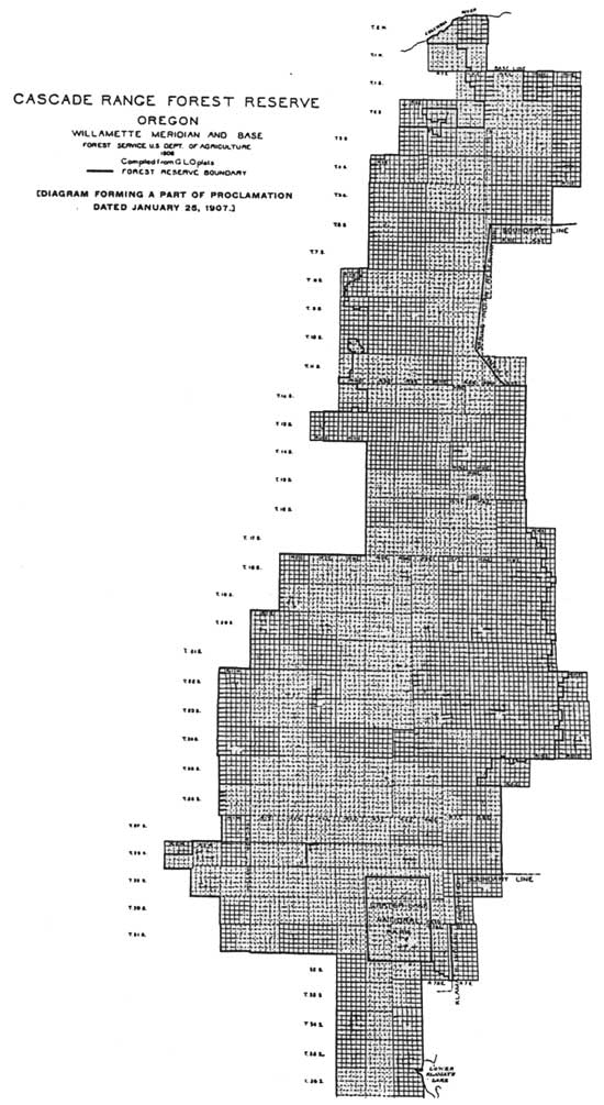
Now, therefore, I, THEODORE ROOSEVELT, President of the United States of America, by virtue of the power in me vested by the Act of Congress, approved June fourth, eighteen hundred and ninety-seven, entitled, "An Act Making appropriations for sundry civil expenses of the Government for the fiscal year ending June thirtieth, eighteen hundred and ninety-eight, and for other purposes," do proclaim that the aforesaid Cascade Range Forest Reserve is hereby further enlarged to include the said additional lands, and that the boundaries of the reserve are now as shown on the diagram forming a part hereof;
Excepting from the force and effect of this proclamation all lands which are at this date embraced in any legal entry or covered by any lawful filing or selection duly of record in the proper United States Land Office, or upon which any valid settlement has been made pursuant to law, and the statutory period within which to make entry or filing of record has not expired; and also excepting all hands which at this date are embraced within any withdrawal or reservation for any use or purpose to which this reservation for forest uses is inconsistent: Provided, that these exceptions shall not continue to apply to any particular tract of land unless the entryman, settler, or claimant continues to comply with the law under which the entry, filing, or settlement was made, or unless the reservation or withdrawal to which this reservation is inconsistent continues in force; not excepting from the force and effect of this proclamation, however, any land within the boundary herein described, which has been withdrawn to protect the coal therein but this proclamation does not vacate any??? such coal land withdrawal; and provided that these exceptions shall not apply to any land embraced in any selection, entry or filing, which has been allowed or permitted to remain of record subject to the creation of a permanent reservation.
Warning is hereby given to all persons not to make settlement upon the lands reserved by this proclamation.
In Witeness Whereof, I have hereunto set my hand and caused the seal of the United States to be affixed.
| [SEAL.] |
DONE at the City of Washington this 25th day of January, in the year of our Lord one thousand nine hundred and seven, and of the Independence of the United States the one hundred and thirty-first.
THEODORE ROOSEVELT
By the President:
ELIHU ROOT
Secretary of State.
THE CASCADE RANGE FOREST RESERVE
OREGON
(FOURTH PROCLAMATION.)
BY THE PRESIDENT OF THE UNITED STATES OF AMERICA.
A PROCLAMATION.
WHEREAS, the Cascade Forest Reserve, in the State of Oregon, was established by proclamation dated September twenty-eighth, eighteen hundred and ninety-three, under the name of The Cascade Range Forest Reserve, and the boundaries thereof have been subsequently changed to include additional lands in the State of Oregon, and also to exclude from the reserve certain lands;
And whereas, it appears that the public good would be promoted by further adding to the said forest reserve certain lands, in the State of Oregon, which are in part covered with timber;
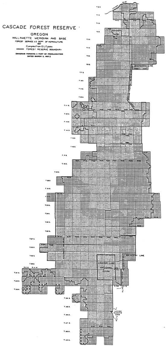
Now, therefore, I, THEODORE ROOSEVELT, President of the United States of America, by virtue of the power in me vested by the Act of Congress, approved June fourth, eighteen hundred and ninety-seven, entitled, "An Act Making appropriations for sundry civil expenses of the Government for the fiscal year ending June thirtieth, eighteen hundred and ninety-eight, and for other purposes," do proclaim that the aforesaid Cascade Forest Reserve is hereby further enlarged to include the said additional lands, and that the boundaries of the reserve are now as shown on the diagram forming a part hereof;
Excepting from the force and effect of this proclamation all lands which are at this date embraced in any legal entry or covered by any lawful filing or selection duly of record in the proper United States Land Office, or upon which any valid settlement has been made pursuant to law, and the statutory period within which to make entry or filing of record has not expired; and also excepting all lands which at this date are embraced within any withdrawal or reservation for any use or purpose to which this reservation for forest uses is inconsistent: Provided, that these exceptions shall not continue to apply to any particular tract of land unless the entryman, settler, or claimant continues to comply with the law under which the entry, filing, or settlement was made, or, unless the reservation or withdrawal to which this reservation is inconsistent continues in force; not excepting from the force and effect of this proclamation, however, any land within the boundary herein described, which has been withdrawn to protect the coal therein but this proclamation does not vacate any such coal land withdrawal; and provided that these exceptions shall not apply to any land embraced in any selection, entry or filing, which has been allowed or permitted to remain of record subject to the creation of a permanent reservation.
Warning is hereby given to all persons not to make settlement upon the lands reserved by this proclamation.
In Witness Whereof, I have hereunto set my hand and caused the seal of the United States to be affixed.
| [SEAL.] |
DONE at the City of Washington this 2d day of March, in the year of our Lord one thousand nine hundred and seven, and of the Independence of the United States the one hundred and thirty-first.
THEODORE ROOSEVELT
By the President:
ELIHU ROOT
Secretary of State.
CASCADE NATIONAL FOREST
OREGON
(FIFTH PROCLAMATION.)
BY THE PRESIDENT OF THE UNITED STATES OF AMERICA.
A PROCLAMATION.
WHEREAS an Executive Order dated June thirtieth, nineteen hundred and eight, directed that a part of the Cascade National Forest, in the State of Oregon, should be known as the Cascade National Forest; and
WHEREAS it appears that portions of the Cascade National Forest should be included in the Santiam National Forest and the Paulina National Forest; and
WHEREAS it appears that a portion of the Umpqua National Forest should be transferred to the Cascade National Forest;
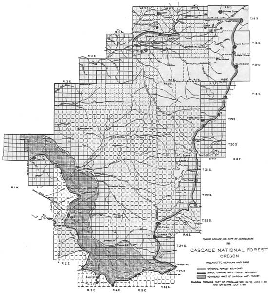
Now, therefore, I, WILLIAM H. TAFT, President of the United States of America, by virtue of the power in me vested by the Act of Congress approved June fourth, eighteen hundred and ninety-seven, entitled "An Act Making appropriations for sundry civil expenses of the Government for the fiscal year ending June thirtieth, eighteen hundred and ninety-eight, and for other purposes," do proclaim that on and after July first, nineteen hundred and eleven, the boundaries of the Cascade National Forest shall be as shown on the diagram forming a part hereof.
This proclamation shall not prevent the settlement and entry of any lands heretofore opened to settlement and entry under the Act of Congress approved June eleventh, nineteen hundred and six, entitled "An Act To provide for the entry of Agricultural lands within forest reserves".???
It is not intended by this proclamation to release any land from reservation nor to reserve any land not heretofore embraced in a National Forest.
In Witness Whereof, I have hereunto set my hand and caused the seal of the United States to be affixed.
| [SEAL.] |
DONE at the City of Washington this seventh day of June, in the year of our Lord one thousand nine hundred and eleven, and of the Independence of the United States the one hundred and thirty-fifth.
WM H TAFT
By the President:
P. C. KNOX
Secretary of State.
[No. 1130.]
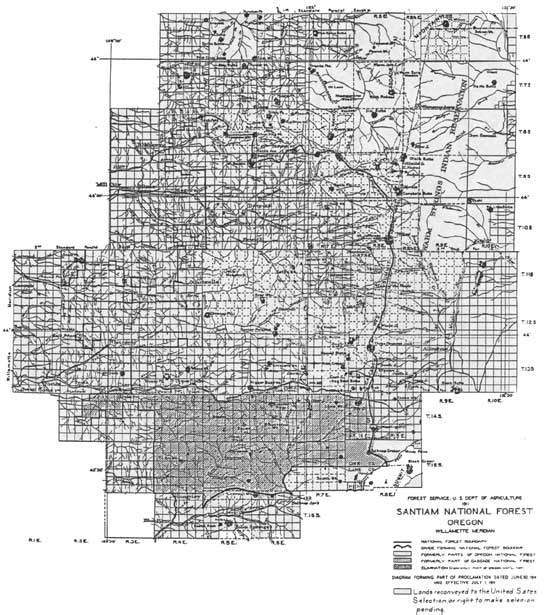
SANTIAM NATIONAL FOREST
OREGON
BY THE PRESIDENT OF THE UNITED STATES OF AMERICA.
A PROCLAMATION.
WHEREAS it appears that portions of the Oregon and the Cascade National Forests, within the State of Oregon, should constitute the Santiam National Forest;
Now, therefore, I, WILLIAM H. TAFT, President of the United States of America, by virtue of the power in me vested by the Act of Congress approved June fourth, eighteen hundred and ninety-seven, entitled "An Act Making appropriations for sundry civil expenses of the Government for the fiscal year ending June thirtieth, eighteen hundred and ninety-eight, and for other purposes," do proclaim that on and after July first, nineteen hundred and eleven, the boundaries of the Santiam National Forest shall be as shown on the diagram forming a part hereof.
This proclamation shall not prevent the settlement and entry of any lands heretofore opened to settlement and entry under the Act of Congress approved June eleventh, nineteen hundred and six, entitled "An Act To provide for the entry of Agricultural lands within forest reserves".???
It is not intended by this proclamation to reserve any land not heretofore embraced in a National Forest, nor to release any land from reservation.
No public land is included in Section twenty-four (24), Township eleven (11) South, Range three (3) East, Willamette Meridian, Oregon, which is eliminated from the Oregon National Forest by a proclamation effective July first, nineteen hundred and eleven, changing the boundaries of said Forest.
In Witness Whereof, I have hereunto set my hand and caused the seal of the United States to be affixed.
| [SEAL.] |
DONE at the City of Washington this thirtieth day of June, in the year of our Lord one thousand nine hundred and eleven, and of the Independence of the United States the one hundred and thirty-fifth.
WM H TAFT
By the President:
HUNTINGTON WILSON
Acting Secretary of State.
[No. 1163.]
EXECUTIVE ORDER
TRANSFER OF LANDS FROM THE
CASCADE AND SANTIAM NATIONAL FORESTS TO THE WILLAMETTE NATIONAL
FOREST
OREGON
Under authority of the act of Congress approved June 4, 1897 (30 Stat. 11, 36; U.S.C., title 16, sec. 473), and on the recommendation of the Secretary of Agriculture, it is hereby ordered that the Cascade National Forest as defined by proclamation of June 7, 1911 (37 Stat. 1684—1685), be consolidated with the Santiam National Forest as defined by proclamation of June 30, 1911 (37 Stat. 1712), and amended by act of February 28, 1925 (43 Stat. 1080). The area hitherto comprising the Cascade and Santiam National Forests shall hereafter be known as the Willamette National Forest.
It is not intended by this order to give any publicly owned lands a national-forest status which have hitherto not had such status, nor to remove any publicly owned lands from a national-forest status.
This order is effective July 1, 1933.
FRANKLIN D ROOSEVELT
THE WHITE HOUSE,
April 6, 1933.
[No. 6104]
| <<< Previous | <<< Contents>>> | Next >>> |
|
region/6/willamette/history/app-1.htm Last Updated: 08-Dec-2008 |