|
Hanford Reach National Monument Washington |
|
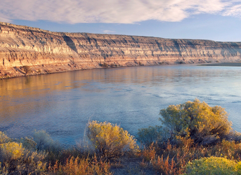 USF&WS photo | |
The Hanford Reach National Monument, comprising over 196,000 acres in arid eastern Washington, was the first national monument for the U.S. Fish & Wildlife Service and broke the mold, so to speak, of what a national wildlife refuge is. Yes, there is abundant wildlife, endangered species, and unique ecosystems. However, no other refuge is so focused on history, cultural resources, geology, paleontology, and other non-wildlife-related resources. Throw in an eligible wild and scenic river—rare for the agency outside of Alaska—and the FWS had to rethink how to manage resources with which it typically had little experience.
The land comprising the Monument has an unusual and colorful provenance. The entry of the United States into World War II and the race to develop an atomic bomb led to a search for a suitable place to locate plutonium production and purification facilities. In 1943, the War Department (later to become the Department of Defense) went in search of a remote, easily defensible, geologically stable site, with plenty of cool water, abundant energy (from hydropower dams on the Columbia River), and a moderate climate, on which to build secret plutonium production reactors. The U.S. Army Corps of Engineers selected a site in Washington State near the isolated desert towns of White Bluffs and Hanford. The War Department acquired land through condemnation and purchase of private lands and withdrawal of public lands within the basin formed by Rattlesnake Mountain and the Saddle Mountains. The Atomic Energy Commission, a precursor to the Department of Energy, then established and ran the Hanford Site (then known as the Hanford Engineering Works).
For more than forty years, the primary mission at the Hanford Site was the production of nuclear materials for national defense. The DOE developed infrastructure and facility complexes to accomplish this work in the central portion of the site, but large tracts of land were used as protective buffer zones for safety and security purposes and remained undisturbed. These buffer zones preserved a nationally significant biological and cultural resource setting in the Columbia Basin region, unique in that similar resources elsewhere in the Columbia Basin have been destroyed or replaced by development.
In the early 1970s, there was a reduced need for large safety and security buffer zones around the Hanford Site, and the DOE transferred management of portions of the “North” or “Wahluke Slope” (the area north of the Columbia River) to the FWS—through the creation of the Saddle Mountain National Wildlife Refuge—and to the Washington State Department of Fish and Wildlife. By the late 1980s, the primary DOE mission had changed from defense materials production to environmental restoration, waste management, and science and technology research, further decreasing the need for a large land base. In 1997, the DOE transferred the administration of the Fitzner-Eberhardt Arid Lands Ecology Reserve (ALE) to the FWS. In 1999, the Wahluke Slope lands managed by the WDFW, known as the Wahluke Wildlife and Recreation Area, were transferred to the FWS to be managed under DOE permit as part of the NWRS.
In the 1980s, concerns for protection of the Hanford Site’s natural and cultural resource values grew, as did interest in consolidating management under one natural resource agency. In 1988, Congress directed the Secretary of the Interior and the Secretary of Energy to identify and evaluate the outstanding features of the Hanford Reach and its immediate environment—including fish, wildlife, geology, scenery, recreation, historic and cultural values—and recommend alternatives for their preservation. The resulting Department of the Interior report, the Hanford Reach of the Columbia River Comprehensive River Conservation Study and Environmental Impact Statement, identified the FWS as best suited to protect those values and the lands necessary to support them. After years of discussion and controversy, the question of protection was settled when President Clinton created the Monument through his powers under the American Antiquities Act.
Source: USF&WS Website (May 2023)
|
Establishment Hanford Reach National Monument — June 8, 2000 |
For More Information Please Visit The  OFFICIAL WEBSITE |
Documents
Comprehensive Conservation Plan
Cultural Resource Review (April 2002)
Geological/Paleontological Review (August 2002)
Visitor Services Review (November 2002)
Wildlife and Habitat Management Review (June 2002)
Comprehensive Conservation Plan, Hanford Reach National Monument (September 2008)
Comprehensive Conservation Plan Planning Update 2, Hanford Reach National Monument (July 2003)
Draft Comprehensive Conservation Plan and Environmental Impact Statement, Hanford Reach National Monument (November 2006)
Hanford Reach National Monument Rattlesnake Unit: Draft Supplemental Environmental Impact Statement for Public Access (August 2018)
Hanford Endemic Plants Population Monitoring (Joseph Arnett, January 17, 2012)
Hanford Facts (Date Unknown)
Hanford Wildlife (March 1992)
Hunting Regulations, Hanford Reach National Monument (August 2023)
Introduction to the Hanford Reach National Monument (Date Unknown)
Map: Hanford Reach National Monument (undated)
Proclamation 7319—Establishment of the Hanford Reach National Monument (William J. Clinton, June 9, 2000)
Recovery and Rehabilitation of Vegetation on the Fitzner-Eberhardt Arid Lands Ecology Reserve, Hanford Reach National Monument, Following the 24 Command Fire (James R. Evans and Marita P. Lih, February 2005)
River Corridor Integrated Land Planning Document DOE/RL-2015-59 (February 2016)
Sport Hunting: Wahluke Unit of The Hanford Reach National Monument (May 2007)
The History of Hanford Reach National Monument (c2002)
White Bluffs at Hanford Reach (Nick Zentner, Date Unknown)
hanford-reach/index.htm
Last Updated: 01-Jan-2025