|
War in the Pacific
Asan and Agat Invasion Beaches Cultural Landscapes Inventory |

|
| PART 1 |
EXECUTIVE SUMMARY
General Introduction to the CLI
The Cultural Landscapes Inventory (CLI) is a comprehensive inventory of all historically significant landscapes within the National Park System. This evaluated inventory identifies and documents each landscape's location, physical development, significance, National Register of Historic Places eligibility, condition, as well as other valuable information for park management. Inventoried landscapes are listed on, or eligible for, the National Register of Historic Places, or otherwise treated as cultural resources. To automate the inventory, the Cultural Landscapes Automated Inventory Management System (CLAIMS) database was created in 1996. CLAIMS provides an analytical tool for querying information associated with the CLI.
The CLI, like the List of Classified Structures (LCS), assists the National Park Service (NPS) in its efforts to fulfill the identification and management requirements associated with Section 110(a) of the National Historic Preservation Act, NPS Management Policies (2001), and Director's Order #28: Cultural Resource Management (1998). Since launching the CLI nationwide, the NPS, in response to the Government Performance and Results Act (GPRA), is required to report on an annual performance plan that is tied to 6-year strategic plan. The NPS strategic plan has two goals related to cultural landscapes: condition (1a7) and progress on the CLI (1b2b). Because the CLI is the baseline of cultural landscapes in the National Park System, it serves as the vehicle for tracking these goals.
For these reasons, the Park Cultural Landscapes Program considers the completion of the CLI to be a servicewide priority. The information in the CLI is useful at all levels of the park service. At the national and regional levels it is used to inform planning efforts and budget decisions. At the park level, the CLI assists managers to plan, program, and prioritize funds. It is a record of cultural landscape treatment and management decisions and the physical narrative may be used to enhance interpretation programs.
Implementation of the CLI is coordinated on the Region/Support Office level. Each Region/Support Office creates a priority list for CLI work based on park planning needs, proposed development projects, lack of landscape documentation (which adversely affects the preservation or management of the resource), baseline information needs and Region/Support office priorities. This list is updated annually to respond to changing needs and priorities. Completed CLI records are uploaded at the end of the fiscal year to the National Center for Cultural Resources, Park Cultural Landscapes Program in Washington, DC. Only data officially entered into the National Center's CLI database is considered "certified data" for GPRA reporting.
The CLI is completed in a multi-level process with each level corresponding to a specific degree of effort and detail. From Level 0: Park Reconnaissance Survey through Level II: Landscape Analysis and Evaluation, additional information is collected, prior information is refined, and decisions are made regarding if and how to proceed. The relationship between Level 0, I, and II is direct and the CLI for a landscape or component landscape inventory unit is not considered finished until Level II is complete.
A number of steps are involved in completing a Level II inventory record. The process begins when the CLI team meets with park management and staff to clarify the purpose of the CLI and is followed by historical research, documentation, and fieldwork. Information is derived from two efforts: secondary sources that are usually available in the park's or regions' files, libraries, and archives and on-site landscape investigation(s). This information is entered into CLI database as text or graphics. A park report is generated from the database and becomes the vehicle for consultation with the park and the SHPO/TPO.
Level III: Feature Inventory and Assessment is a distinct inventory level in the CLI and is optional. This level provides an opportunity to inventory and evaluate important landscape features identified at Level II as contributing to the significance of a landscape or component landscape, not listed on the LCS. This level allows for an individual landscape feature to be assessed and the costs associated with treatment recorded.
The ultimate goal of the Park Cultural Landscapes Program is a complete inventory of landscapes, component landscapes, and where appropriate, associated landscape features in the National Park System. The end result, when combined with the LCS, will be an inventory of all physical aspects of any given property.
Relationship between the CLI and a CLR
While there are some similarities, the CLI Level II is not the same as a Cultural Landscape Report (CLR). Using secondary sources, the CLI Level II provides information to establish historic significance by determining whether there are sufficient extant features to convey the property's historic appearance and function. The CLI includes the preliminary identification and analysis to define contributing features, but does not provide the more definitive detail contained within a CLR, which involves more indepth research, using primary rather than secondary source material.
The CLR is a treatment document and presents recommendations on how to preserve, restore, or rehabilitate the significant landscape and its contributing features based on historical documentation, analysis of existing conditions, and the Secretary of the Interior's standards and guidelines as they apply to the treatment of historic landscapes. The CLI, on the other hand, records impacts to the landscape and condition (good, fair, poor) in consultation with park management. Stabilization costs associated with mitigating impacts may be recorded in the CLI and therefore the CLI may advise on simple and appropriate stabilization measures associated with these costs if that information is not provided elsewhere.
When the park decides to manage and treat an identified cultural landscape, a CLR may be necessary to work through the treatment options and set priorities. A historical landscape architect can assist the park in deciding the appropriate scope of work and an approach for accomplishing the CLR. When minor actions are necessary, a CLI Level II park report may provide sufficient documentation to support the Section 106 compliance process.
|
Park Information | ||||||||||||||||||||||||||||||||||||||||
| Park Name: | War in the Pacific National Historical Park | |||||||||||||||||||||||||||||||||||||||
| Administrative Unit: | War in the Pacific National Historical Park | |||||||||||||||||||||||||||||||||||||||
| Park Organization Code: | 8790 | |||||||||||||||||||||||||||||||||||||||
| Park Alpha Code: | WAPA | |||||||||||||||||||||||||||||||||||||||
|
Property Level And CLI Number | ||||||||||||||||||||||||||||||||||||||||
| Property Level: | Component Landscape | |||||||||||||||||||||||||||||||||||||||
| Name: | Asan and Agat Invasion Beaches | |||||||||||||||||||||||||||||||||||||||
| CLI Identification Number: | 975116 | |||||||||||||||||||||||||||||||||||||||
| Parent Landscape CLI ID Number: | 725542 | |||||||||||||||||||||||||||||||||||||||
Inventory Summary | ||||||||||||||||||||||||||||||||||||||||
| Inventory Level: | Level II | |||||||||||||||||||||||||||||||||||||||
Completion Status:
| ||||||||||||||||||||||||||||||||||||||||
Component Landscape Description
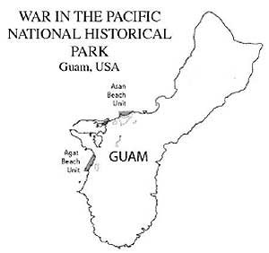
Asan Beach Unit and Agat Beach Unit is considered one of five component landscapes within the War in the Pacific National Park. These beaches, although not contiguous, are the two landing beaches of the American military forces on July 21, 1944. Beach areas were chosen by the U.S. Navy because the natural features presented the most opportunity to land, establish a foothold, transfer supplies onto the island, and advance to secure the Orote Peninsula and the Island of Guam. Both beaches were the battlefields of the first and most intense combat between American and Japanese troops. Both landing beaches were the first and crucial sites of one military strategy.
The Asan Beach Unit consists of 109 acres of land and 445 acres offshore. The Agat Beach Unit consists of 38 land acres and 557 acres offshore.
Cultural Landscapes Inventory Hierarchy Description
War in the Pacific National Historical Park is located on the west-central coast of the Island of Guam in the Pacific Island Cluster of the Pacific West Region. War in the Pacific National Historical Park is comprised of a single park-wide landscape with five noncontiguous component landscapes: Asan and Agat beach units, Asan Inland Unit, Mt. Alifan, Mt. Chachao and Mt. Tenjo, and Piti Guns (see heirarchy description graphic). Asan and Agat Invasion Beach Units are the two invasion beaches where American troops landed on July 21, 1944 with the intent of liberating the island of Guam from Japanese military occupation. Asan and Agat Invasion Beaches are the battlefields of Phase I of the United States invasion. Other than Asan and Agat Invasion Beaches, there are four remaining units of the park. The four noncontiguous units, Asan Inland Unit, Mt. Alifan, Mt. Chachao and Mt. Tenjo, Piti Guns also played important roles in the battle, but after the beach heads were secured. These four units are high ground, ridges and mountains that surround two landing beaches and were crucial to the Japanese defense.
|
WAR in the PACIFIC NATIONAL HISTORICAL PARK CULTURAL LANDSCAPE |
|
Asan and Agat Invasion Beaches Asan Inland Unit Mt. Alifan Unit Mt. Chachao and Mt. Tenjo Unit Piti Guns Unit |
War in the Pacific National Historical Park is comprised of five parent landscapes including Asan and Agat Invasion Beaches (CLI Team/PISO/2003).
Location Map
Location map showing the island of Guam and the Asan and Agat Beach Units (CLI Team/PISO/2003).
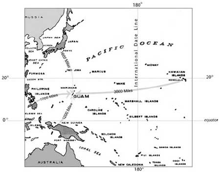
Location map showing the Island of Guam in the South Pacific (CLI Team/PISO/2003).
Boundary Description
Asan Beach Unit and Agat Beach Unit are two of the seven units that make up the War in the Pacific National Historical Park. This CLI report assesses resources on land within the authorized park boundaries of Asan and Agat beach units. The park authorized boundary and the cultural landscape boundary are the same.
The National Park Service (NPS) authorized park boundary encompass specific resources related to World War II on parcels owed by the NPS (federal), the Government of Guam (public), and private landowners. The intent in the Proposed Master Plan (1967:3) states: "...acquisition of specific lands for protection and development purposes with territorial zoning of certain adjoining lands in order to preserve valid historic scenes for interpretive purposes." The original intent was for the NPS to acquire land within the designated park boundaries as it became available for purchase (Public Law 95-348 95th Congress August 18, 1978). Asan and Agat beach units are comprised of lands near and around the towns of Agat and Asan. Therefore, within the authorized park boundaries there are mixtures of historic parkland adjoining residential and commercial lands.
The Asan Beach Unit contains 109 land acres and 445 acres of water, of which 238 acres are federally owned by the NPS (see site plan section for the land ownership map). It is one continuous section of land three miles west of Agana, the capitol of Guam. It also surrounds the village of Asan. The proposed boundary for Asan begins on the western edge of Adelup Point and extends to the western edge of Asan Point along the Matgue River. The southern boundary is Marine Drive and the northern boundary is offshore.
The Agat Beach Unit contains 38 land acres and 557 acres of water, of which 63 acres are federally owned by the NPS (see site plan section for land ownership map). The land portions are noncontiguous but share a common eastern boundary, Highway 2. The offshore or western boundary is a continuous line along the coral reef from Bangi Point, north to Apaca Point. Apaca Point is the northern most segment containing the delta of the Namo River and two large coral outcroppings. Ga'an Point, the center segment, is approximately one mile south of Apaca Point. One small parcel just south of the village of Agat is owned by NPS but has no visitor improvements. Bangi Point and Alutom Island located at the southern end.
Regional Context
Cultural Context
As early as 2000 B.C., the Chamorro people migrated from Southeast Asia to settle in Guam. In 1521, Magellan was the first explorer to land on Guam and by 1565 the Spanish began to colonize and send missionaries to convert people to Catholicism. The first Spanish settlement, established in 1668, remained under Spanish rule until United States acquired the island in the Spanish-American War in 1898. During the Spanish rule, Chamorro population declined (Rogers 1995:79) and Filipinos and Carolinians (from the western Carolines) were imported to repopulate the island, manage Spanish cattle herds and provide additional labor. This migration pattern continued throughout the period of American rule. Today, Chamorro, Carolinian, Spanish, and Filipino tradition and culture remain an important part of Guamanian life and culture.
Political Context
Guam is an unincorporated United States flag territory. Guamanians are United States citizens but do not vote in United States presidential elections. As of July 1950, the people of Guam were granted civilian rule through the Organic Act of Guam. There are three branches of government: the executive, the legislative, and the judicial. The island's first elected governor (the highest political position) was elected in 1970.
Physiographic Context
Guam is the largest and southernmost of the Mariana Islands chain. Guam is located at 13 degrees north latitude and is approximately 209 square miles in area. This tropical islands northern half is a limestone plateau with 50-foot cliffs descending into the sea. The southern half of the island is a series of volcanic mountains along the western coast and smaller, gentler volcanic hills sloping toward the east. Coastlines vary from pitted coral limestone to swampy wetlands, to sand beaches. The sea to the west of Guam and the Philippine Sea and to the east is the Pacific Ocean. Coral reefs surround most of the island. The ocean depts drop dramatically beyond the fringing reefs.
Site Plan
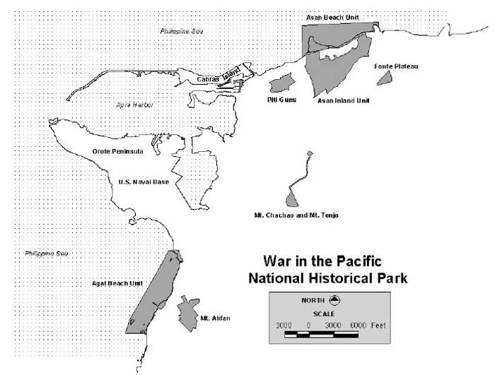
War in the Pacific National Historical Park noncontiguous units
includes Asan Beach Unit, Agat Beach Unit, Asan Inland Unit, Fonte
Plateau Unit, Mt. Chachao and Mt. Tenjo, Mt. Alifan Unit and Piti Guns
Unit (click on image for an enlargement in a new window) (CLI Team/PISO/2003).
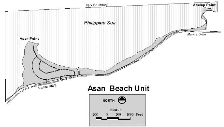
Asan Beach Unit (click on image for an enlargement in a new window) (CLI Team/PISO/2003).

Agat Beach Unit (click on image for an enlargement in a new window) (CLI Team/PISO/2003).

Asan Beach Unit land ownership map (click on image for an enlargement in a new window) (CLI Team/PISO/2003).

Agat Beach Unit land ownership map (click on image for an enlargement in a new window) (CLI Team/PISO/2003).
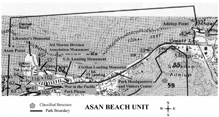
Map of the structures located in the Asan Beach Unit (click on image for an enlargement in a new window) (CLI Team/PISO/2003).

Map of structures located in the Agat Beach Unit (click on image for an enlargement in a new window) (CLI Team/PISO/2003).

Existing vegetation map of the Asan Beach Unit (click on image for an enlargement in a new window) (CLI Team/PISO/2003).

Existing vegetation map of the Agat Beach Unit (click on image for an enlargement in a new window) (CLI Team/PISO/2003).

Existing vegetation map of the Agat Beach Unit (click on image for an enlargement in a new window) (CLI Team/PISO/2003).
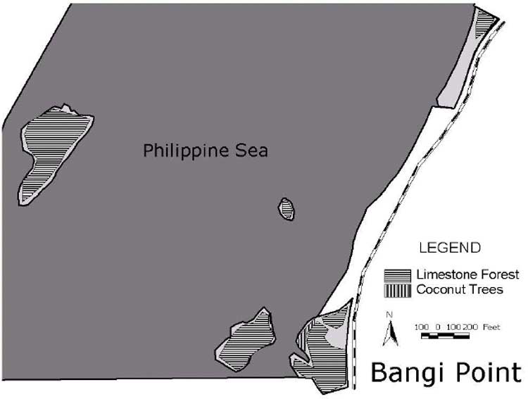
Existing vegetation map of the Agat Beach Unit (click on image for an enlargement in a new window) (CLI Team/PISO/2003).
Chronology
| Year | Event | Description |
| 2000 BC | Settled | 2000 BC - Guam inhabited by people migrating out of Southeast Asia. |
| 1521 AD | Explored | Ferdinand Magellan, the Spanish Captain of The Trinidad, is the first European to land on Guam. |
| 1664 - 1898 AD | Colonized | Spanish period in the colonization of Guam. |
| 1898 AD | Purchased/Sold | United States purchases Guam, Philippines and Puerto Rico from Spain as settlement for the Spanish-American War. |
| 1898 - 1941 AD | Settled | First American period of settlement on Guam. |
| 1900 AD | Destroyed | Typhoon destroys the last Spanish leprosarium on Asan Beach. |
| 1900 AD | Moved | Apolinario Mabini and other Filipino prominent civilians and revolutionary generals from the Philippines are banished to Guam (Asan Beach) by the U.S. Government because they refused to take an oath of allegiance to the United States. |
| 1917 AD | Retained | Enlisted German Navy crew held at the detention facility on Asan Beach by the U.S. Military. |
| 1922 AD | Established | U.S. Marines establish a quartermaster depot at Asan Point, which includes a small practice range and barracks. |
| 1940 - 1941 AD | Removed | U.S. Navy engineers use outer edge of Asan Point to quarry limestone. |
| 1941 - 1944 AD | Colonized | Japan invades Guam only hours after attacking Pearl Harbor, Hawaii and occupies the island for four years. |
| 1941- 1944 AD | Colonized | Japanese occupy Guam and destroy all existing American military buildings and begin establishing rice paddies for food production for the soldiers. |
| 1941-1970 AD | Built | Mole (rock rubble breakwater) is built just offshore of Asan point creating an inner reef flat platform. Date of construction is unknown, however, it was possibly built during the United States presence on Guam (between 1941-1970's). |
| 1944 AD | Built | A four-lane, 12 mile super highway with 9 bridges between Agana and Sumay is completed by U.S. Navy Seabees and U.S. Army Engineers. |
| 1944 AD | Built | American Seabees follow invasion troops ashore and immediately begin road construction. |
| 1944 AD | Colonized | United States declare sovereignty over Asan and Agat landing beaches and the entire Island of Guam. |
| 1944 AD | Destroyed | U.S. Navy Task Force 53 and 58 start intense preinvasion bombardment of Guam's landing beaches (Asan and Agat). Vegetation and existing buildings are destroyed. |
| 1944 AD | Destroyed | U. S. Navy demolition teams destroy 640 Japanese-built defense obstacles offshore of Asan Beach and 300 offshore of Agat Beach. |
| 1944 AD | Established | Forager - Phase I begins. 3rd Marine Division and 1st Provisional Marine Brigade invade and establish a foothold on Asan and Agat beaches. |
| 1944 AD | Explored | Submarines and long-range submarines begin photographing and conducting reconnaissance of Guam including both landing beaches (Asan and Agat). |
| 1944 AD | Moved | American units liberate large groups of Guamanians held in concentration camps. Guamanian relief camps were set up at Asan and Agat beaches. |
| 1944 AD | Planted | U.S. Navy conducts aerial seed dispersal of an introduced legume (tangen-tangen) to reduce soil erosion, especially on ridges such as the Asan Ridge. |
| 1944 AD | Removed | U.S. Army Engineers use outer edge of Asan Point to quarry limestone. |
| 1944 AD | Settled | Guamanians begin returning to their homes and ranches and rebuilding their villages. |
| 1965 AD | Built | A U.S. Navy hospital is built during the Vietnam War (ca. mid-1960's) on Asan Beach. Over 40 quanset huts were arranged in a semi-circular pattern with a concrete crescent-shaped drive. The existing entry road to Asan Beach Unit follows this same pattern. |
| 1975 AD | Abandoned | Vietnam refugee camp on Asan Beach is closed. |
| 1975 AD | Preserved | Agat Invasion Beach is listed in the National Register of Historic Places. |
| 1975 AD | Rehabilitated | An old Navy hospital building on Asan Beach is converted into a refugee camp in order to hold Vietnamese refugees. |
| 1978 AD | Preserved | War in the Pacific National Historical Park placed on the National Register of Historic Places. |
| 1979 AD | Preserved | Asan Invasion Beach listed on the National Register of Historic Places. |
| 1997 AD | Destroyed | Typhoon Paka, with winds up to 236 mph causes damage to Asan and Agat beaches, destroying sidewalks, vegetation, and altering the shoreline. |
| 2002 AD | Destroyed | Super-Typhoon Pongsona causes damage to Asan and Agat beaches, destroying facilities along the shoreline, vegetation, sidewalks, and roads and altering the shoreline. |
Statement of Significance
War in the Pacific National Historical Park is the battlefield where the United States defeated Japan and liberated Guam. The island was initially attacked by the Japanese only hours after the Pearl Harbor attack (December 7, 1941 in Hawaii, December 8th in Guam (across the international dateline). Guam fell to the Japanese on December 10th, 1941. The Japanese occupied the island for two and one half years until American forces regrouped, reorganized and turned their attention to re-securing their presence in the Pacific. On July 21, 1944, American troops landed on Asan and Agat beaches. The island was considered secured twenty days later, on August 10th, 1944.War in the Pacific National Historical Park was listed on the National Register in 1978. Asan and Agat beach units were listed on the National Register as invasion beaches. Asan Invasion Beach was listed in 1979 and Agat Invasion Beach was listed in 1975. These landscapes and their associated features remain from a significant event in our national history. Criteria A (Event) - as a landscape that was associated with an event that made a significant contribution to the broad patterns of American history. Asan and Agat beach units also hold potential to yield important information. Criteria D (Information Potential) - may likely yield important prehistory or historic archeological information. The period of significance for the Asan and Agat invasion beaches is 1941 to 1945, marking the beginning and ending of the War in the Pacific. The landscape characteristics that contribute to the period of significance are buildings and structures, archeology, natural systems and features, spatial organization, topography, vegetation and views and vistas.
Asan and Agat beaches both contain coral rock outcroppings up to 100 feet high, and these provided vantage points, natural camouflage, and fields of fire over the beaches for the Japanese. These outcroppings were the best location for the Japanese to build defense structures. Pillboxes, bunkers, gun emplacements and batteries were built into the natural crevices and caves. When U.S. Navy pre-invasion strategists studied cloudy aerial photographs, the outcroppings were mistaken as simple sand hills and the gun emplacements did not show through heavy vegetation. Therefore, defense structures were not bombed during the pre-invasion aerial attack. This oversight caused the initial invasion to be much more difficult and costly to the American troops. These defense positions became Japanese strongholds from which intense artillery fire poured down on advancing Americans before they even reached the shore. "The men soon learned that terrain, rather than the enemy, would be their worst obstacle the first day ashore" (Lodge 1998:40).
Asan and Agat beach sites are both known to have been primary habitation sites from the period of initial contact and throughout the subsequent history of Spanish, Japanese, and American occupation. It can be assumed that these sites would likely yield subsurface archeological information. Although no specific archeological studies have been done on Asan or Agat beach units, it is probable that they contain subsurface information from WWII, pre-war, the Spanish Occupation Period, and periods of pre-history (Latte and Pre-Latte).The natural terrain designated that Asan and Agat beaches would be the primary landing areas and initial battlefields. These two invasion beaches are located six miles apart, on the west central coast of the Island of Guam. Asan is the northern landing beach and Agat is the southern landing beach. Both beaches are enclaves, backed by high foothills and ridges of Mounts Alifan, Chachao, Tenjo, and the Fonte Plateau. Asan and Agat beaches were separated by the Orote Peninsula. The Orote Peninsula, edged with 200-foot sea cliffs, contained the only functional airfield on the island and enclosed the north side of the Apra Harbor. This natural terrain was an asset to defensive troops which favored the Japanese forces and influenced the American offense strategy.
Securing the high ground was an essential part of the American invasion strategy, and an offensive line was drawn on the map extending from Facpi Point (south of Agat Beach) along the ridgeline to Adelup Point (northern edge of Asan Beach). This became the primary objective known as the Force Beachhead Line (FBL). American forces were to 1) establish a foothold on the two invasion beaches, 2) advance forward converging and securing the Orote Peninsula, and 3) capture the FBL. Therefore, although Asan and Agat battlefields were miles apart, they were part of one strategic plan, and the first major tactical maneuver to liberate Guam.Asan and Agat beaches became the initial landing fields, battlefields and sites of the most intense combat. This first day resulted in over 600 American and 200 Japanese casualties. By the morning of July 22, both beaches were secure and became supply nodes where supporting troops, medical supplies, personnel, artillery, and equipment were transferred from American ships anchored offshore. Once Asan and Agat beaches were secure, America again had a foothold on Guam and liberation of the island and its people. These battlefields commemorate the efforts by American troops to protect the United States Territory and liberate the people of Guam from Japanese oppression.
| <<< Previous | <<< Contents >>> | Next >>> |
wapa/cri/part1.htm
Last Updated: 03-may-2004