| Marines in World War II Commemorative Series |
|
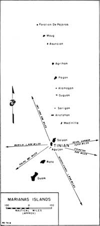
A CLOSE ENCOUNTER: The Marine Landing on Tinian by Richard Harwood Three weeks into the battle for Saipan, there was no doubt about the outcome and V Amphibious Corps (VAC) commanders began turning their attention to the next objective—the island of Tinian, clearly visible three miles off Saipan's southwest coast. Its garrison of 9,000 Japanese army and navy combatants, many of them veterans of the campaigns in Manchuria, had been bombarded for seven weeks by U.S. air and sea armadas, joined in late June by massed Marine Corps and Army artillery battalions on Saipan's southern coast. The 2d and 4th Marine Divisions, both still in the thick of the Saipan fight, had been selected for the assault mission. The crucial question of where they would land, however, was still undecided. There was strong support among the planners for a landing on two narrow sand strips—code named White 1 and White 2—on Tinian's northwest coast; one was 60 yards wide, the other 160. But Vice Admiral Richmond K. Turner, overall commander of the Marianas Expeditionary Force, was skeptical. He leaned toward Yellow Beach, made up of several wide, sandy strips in front of Tinian Town, the island's heavily fortified administrative and commercial center.
On 3 July, VAC's Amphibious Reconnaissance Battalion, commanded by Captain James L. Jones, was put on alert for reconnaissance of these potential landing sites. On 9 July, the day Saipan officially was declared secured, Jones got his operation order from Marine Lieutenant General Holland M. Smith, commander of Expeditionary Troops. His men were to scout out the Tinian beaches and their fortifications and determine their capacity to handle the landing force and keep it supplied. Accompanying naval underwater demolition teams would do the hydrographic work and locate underwater obstacles, natural or man-made. Captain Jones picked for the job Company A under the command of Captain Merwin H. Silverthorn, Jr., the son of a Marine general and World War I veteran, and Company B, commanded by First Lieutenant Leo B. Shinn. The Navy assigned to the mission Underwater (UDT) Team 5, led by Lieutenant Commander Draper L. Kauffman, and UDT Team 7 under Lieutenant Richard F. Burke. They rehearsed the operation on the night of 9-10 July off the beaches of Saipan's Magicienne Bay. On the evening of the 10th, the Marine and Navy units boarded the destroyer transports Gilmer and Stringham for the short trip into the channels separating the two islands. The teams debarked in rubber boats at 2030, paddled to within 500 yards of the beach and swam to their destinations. Fortunately, it was a black night and although the moon rose at 2230, it was largely obscured by clouds. Yellow Beach was assigned to Silverthorn's Company A. He led 20 Marines and eight UDT swimmers ashore. They found a beach near Tinian Town flanked on each side by formidable cliffs. There were many floating mines and underwater boulders in the approaches. On the beach itself, double-apron barbed wire had been strung. Second Lieutenant Donald F. Neff worked his way 30 yards inland to locate exit routes for vehicles. Nearby, talkative Japanese work crews were building pillboxes and trenching with blasting charges. Neff spotted three Japanese sentries on a cliff overlooking the beach; now and then searchlights scanned the beach approaches. Silverthorn, Burke, and their men made it back to the Gilmer safely. Their impression of Yellow Beach as a landing site was distinctly unfavorable.
To the north, at the White Beaches assigned to Company B, things had not gone well. Strong currents pushed the rubber boats off course. The team headed for White 1 was swept 800 yards north of its destination and never got ashore. The party headed for White 2 wound up on White 1 and reconnoitered the area. Both parties were picked up by the Gilmer. The next night 10 swimmers from Company A were sent back to reconnoiter White 2 and had a successful trip. The reports on the White beaches were encouraging. Although the landing areas were very restricted, it was concluded that amphibian tractors (LVTs) and other vehicles could negotiate the reefs and get ashore, and that troops with little difficulty could clamber over the low cliffs flanking the beaches. Marines forced to disembark from boats at the reef could safely wade ashore through the shallow surf. Members of Kauffman's UDT party confirmed the Marine findings and reported that "no mines or manmade underwater obstructions were found." A few hours after the reconnaissance team returned from White 2, Admiral Turner's objections were withdrawn and a command decision to use the northern beaches was made. On 20 July, a time and date for the landing were fixed: 0730 on 24 July.
|


