|
YELLOWSTONE
The History of the Construction of the Road System in Yellowstone National Park, 1872-1966 Historic Resource Study, Volume I |

|
|
Part One: The History of the Construction of the Road System in Yellowstone National Park, 1827-1966 and the History of the Grand Loop and the Entrance Roads |
CHAPTER XIII:
HISTORY OF NORTH ENTRANCE ROAD
A route from the Upper Yellowstone Valley to Mammoth Hot Springs area existed prior to the creation of Yellowstone National Park in 1872, but it would be many years before the route could be called a road. In 1879, Superintendent Philetus Norris termed "a portion of the canon of the main Gardiner [sic], and all of those of the west and middle branches, are utterly impassable for even a bridle path." [1] Two different routes left the mouth of the Gardner River for the springs, but neither were passable, and Norris did not want to expend much valuable money on their improvement. He spent considerable time trying to site a suitable location. "In this I finally succeeded, and without sharp curvatures, carried a line of easy grades for some 3 miles, and with only a moderate amount of bridging, constructed a road much shorter and in all respects superior to what could have ever been made upon either of the other routes at manifold its cost." [2] Norris avoided the Gardner River Canyon and constructed a road in the approximate location as the older tourist route.
The North Entrance remained the most popular entrance into the Park, and the usage was increased after the Northern Pacific Railroad completed their line to near Gardiner, Montana in 1883. One of the first jobs the Army Corps of Engineers undertook was the improvement to the four miles section of road between Gardiner, Montana and Mammoth Hot Springs costing about $50. After filling the ruts and removing the stumps on the old road, Lt. Dan Kingman recommended abandoning the route for a new one, following the Gardner River through the canyon. The steep inclines of the old road presented many problems particularly to the freighters and especially in wet weather. [3]
Kingman knew that the canyon route, with its exceptional obstacles, would be expensive to construct and estimated that it would cost approximately $2,000 per mile, which is more than double what it would cost in other areas of the Park. During 1883, he spent $5,740 and estimated an additional $3,000 would be needed to complete the job. Before the crews stopped for the winter, an excellent road had been constructed up to the point of the rock work. Kingman hoped to complete the entire project before the first visitors arrived the following spring. [4]
In the Annual Report for 1889, several bridges, without specific locations, spanning the Gardner River were listed
three spans of 33 feet—no truss
three spans of 32 feet—King post
one span of 28 feet, a coulee—no truss
two spans of 40 feet and 20 feet—King and Queen post [5]
During 1901 and 1902, Hiram Chittenden supervised work on the road and in 1903, one his major achievements, the construction of the North Entrance Arch was completed. Chittenden felt that the heavily traveled, highly visible northern park entrance at Gardiner deserved an impressive entrance gate. The Northern Pacific Railway's train station, designed by Robert Reamer, had been completed adjacent to the park boundary on the western edge of Gardiner and the new route into the park was scheduled for construction. The railroad and the wagon roads ended in two loops, with the train station placed in between. One side of the station was used to unload the passengers and the other side, for the conveyance of carriages. On the carriage driveway side, an artificial pond was constructed. Approximately 30 feet above the train station grounds, Chittenden constructed the entrance arch. The corner stone for the entrance arch was laid in a ceremony attended by President Theodore Roosevelt on April 24, 1903, and the first visitors passed through the arch on September 1, 1903. [6]
By 1903, the Army road was widened to 25 feet, the grades had been reduced to 8%, and the road had been surfaced with gravel or macadam. All of the old wooden culverts had been replaced with vitrified clay-pipe or cast-iron culverts. The four crossings of the Gardner River were bridged with steel structures set on monolithic concrete abutments. [7]
During the autumn of 1906, a dry slide occurred near the first bridge from Gardiner, followed my more sliding during the winter. Another slide developed 1-1/2 miles further down the road which was removed by sluicing. Other 1907 spring damage was described:
Next to the slides the most expensive work has been in keeping the road from being washed out. Large boulders aggregating more than 200 tons, fell in a section of the Gardiner [sic] River less than 150 feet in length, one boulder alone weighing approximately 75 tons. This rock had to be removed in order to keep the road from being washed out. Upward of 20 breaks in the wall occurred in the vicinity of 1-1/2 miles from Gardiner. The wall along the river is a dry wall and the water rushing down washes out the material behind the rocks and below the water. The result is that the road is all undermining along the wall, which always gives away during high water, when it is most difficult to repair. . . . On one occasion it was necessary to take a few men available and work two days and a night save, for a few hours in the early morning. Too much stress cannot be laid upon the fact of these dry walls must be replaced by those laid in mortar. . . . I am firmly of the opinion that if the water in the Gardner River is as high next summer as it has been this season, that someday the road will be so washed out as to require using the old road from Gardiner to Mammoth Hot Springs which runs over the hills and which has not been used for 12 years or more. [8]
Severe damage and deterioration effected this section of road for many years. The following excerpts from reveal the extent of the problem.
1908— . . .considerable work was again required at the slide in the bend about 1-1/2 miles from Gardiner, which has been troublesome for more than a year. An additional 2,000 yards or more of earth were removed and it was thought that with the quantity removed a year ago, it was secure but proved again troublesome on account of the numerous openings which are in the sidehill. A few yards below this slide difficulty was again experienced during high water in keeping the road from being washed out. The wall at this point was faced with planks which were held in place by large steel bars. This section probably a stretch of 100 yards of dry rubble, should be laid in mortar this season.
1909— . . .Trouble was again encountered at the slide on the Mammoth Hot Springs to Gardiner road about 1-1/2 miles from Gardiner. It was necessary to remove about 500 yards of earth which slipped into the road from the steep hillside. Efforts have been made to eradicate the troublesome spring here by diverting the small stream on the hill above but so far no marked results have been secured. The retaining wall in the bend of the Gardner River at this point was rebuilt in March 1909, but a portion of it, as well as parts of the old wall, both below and above the bend were washed out by the very high water in the Gardner River in the early part of June. The water at this bend has quite a fall and strikes the wall at right angles. The road was saved by the construction of a revetment of logs and sand bags held by heavy iron bars at those points where the retaining wall gave way. It will be necessary to either relocate the road at this point or to construct a substantial wall of masonry or concrete.
1911— . . .A concrete retaining wall, 487 feet long was constructed about 3-1/2 miles from Mammoth Hot Springs. This is the first concrete revetment wall constructed in the park. . . . the dry rubble wall along the Gardner River is in bad condition.
1912— . . .I think it well to call your attention to the condition of the road between here and Gardiner. The heavy teams hauling in your winter supply of coal so shook the road at the dangerous and narrow part that a section of it fell into the river, leaving a roadway of only about 3 feet in width for a distance of about 12 feet.
The bridge, about 1-1/2 miles from Mammoth Hot Springs, 48 feet long and 16 feet wide, consists of four stringers carrying a pole floor. The two outside stringers are in fairly good condition, but the middle ones are in an advanced state of decay. Two braces, each 22 feet long and 10 inches in diameter are necessary to keep the abutments from sliding down hill towards each other. About 100 feet of side-hill grading opposite the lake is needed. Near Gardiner a 10 feet culvert is to be built as there is no timber within two miles of this point, the culvert can be built of rock, leaving spaces wide enough to carry the stream of water.
. . . there is a sliding bank above the road caused by seepage water from a lake some distance back from the road. Steps were taken last fall to divert the drainage of the country behind the lake and to drain the lake. The sliding bank, for a distance of about 1,000 feet had, last summer and fall, covered about half of the road and will have to be cleared out next summer. Along this sliding bank and in the near vicinity the retaining wall along the river is in bad condition and about 1,000 feet of concrete wall, 9 feet high is needed. Last fall, this road was nearly closed by the sliding bank.
. . . the past week of warm weather and rains has caused the Gardner River to rise rapidly and it is now washing away the earth and the stone retaining wall. I expect the road to go any day. Authority granted to expend 500 dollars park revenue for repairs to old trail, commencing Mammoth Hotel running due north and entering Park road about alfalfa field, . . . .
This wagon trail was practically impassable for any class of vehicles on account of earth slides, boulders, broken culverts and an unserviceable bridge. The work done consisted of dismantling the old wooden bridge and the construction of a timber bridge with a span of 25 feet and 12 feet approach at each end. This bridge spans a ravine about 25 feet deep. All other culverts and bridges were built of rough timber, these varied in length from 4 to 16 feet. Many boulders were removed from the road by blasting and excavating, plowing was done where necessary and the entire length of trail was graded. Widening was also done in many places, leaving this trail in good condition for light vehicle traffic.
1913— . . .A 24 inch metal culvert 130 feet long was placed at the entrance arch to carry the spring flood water. Six hundred and fifty feet of retaining wall, built of rubble laid in cement mortar was constructed along the Gardner River and the old dry rubble wall was patched in numerous places. High water in the spring of 1913 developed several new bad places in the wall and several hundred feet of wall along this road will be replaced during the coming year. . . . The road was widened at several places, the gravel bank near Gardiner was sloped back, a retaining wall was built along the slide at the two mile post, and a large part of the slide removed, and practically the entire road regraveled.
1915— . . .slide is located just above the 2 mile post from Gardiner and a length along the road of nearly 800 feet. Sluicing was begun with the pump installed last fall and a few days later with water from a lake nearly 200 feet above the road at the slide. . . .During the month, one-half mile, between the Entrance Arch and freight road, was completed and oiled with a light layer of sand and gravel on top. . . . [9]
Throughout the summer of 1917, the crews worked diligently to keep the canyon road open, but the 1918 spring thaw caused extensive damage to one mile of the road. One of the last projects, the Army Corps of Engineers supervised before turning over the road construction and improvements to the newly created National Park Service, was making improvements to the old wagon or freight road as it had to be used while the main road could be reconstructed. [10]
Despite recommendations from the Army Corps of Engineers that the entrance road be reconstructed over the hill, National Park Service Director Stephen Mather favored reconstruction through the canyon. In fact, he called the construction of a new road through the Gardner River Canyon the first important engineering project undertaken by the newly formed engineering division. [11] However, the annual reports for the next few years indicate that mostly improvements and not reconstruction were undertaken. In 1920 considerable graveling, some grading and log cribbing was placed to prevent washing out by flood waters. In 1921, 1,300 cubic yards of material was moved from the slide area which had moved 15 feet during the past year. In 1923, about 400 feet of road near the 2 mile post was widened and 1700 cubic yards of rock was blasted from the sandstone cliffs above roadway. [12]
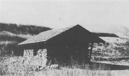
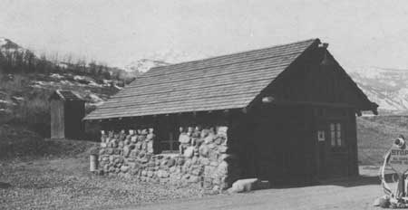
In August and September of 1921, a new stone building to house rangers assigned to checking traffic at the North Entrance was built. The new building replaced an "unsightly tent arrangement" near the Arch. The building, which was compatible in design and material, to the basaltic rock arch, was 15 feet by 16 feet, with walls 24 inches thick. The masonry walls were 8 feet 6 inches in height with 2 logs 7 inches in diameter resting upon them. The dovetailed log constructed gables were covered with a cedar shake roof. The porch was constructed of flagstones embedded in cement mortar. [13]
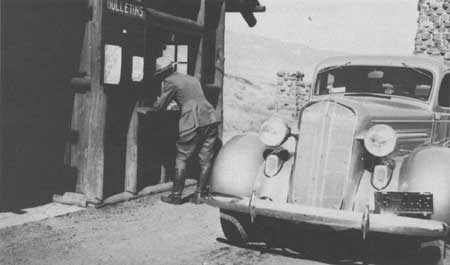
During the 1930s, several plans for the road's relocation and/or reconstruction were discussed. [14] In March 1937, a fire destroyed the checking station near the North Entrance Arch. A temporary station was built several hundred feet east of the burned station. [15]
On August 18, 1941, a severe storm hit the northern part of the Park. The North Entrance Road was closed for several hours because of several slides and washouts. Many of the culverts were blocked with debris. Gas shovels and patrol graders were used by the maintenance crew over the following ten days to put the road in good order. [16]
As a result of the 1959 earthquake, some repair work was done in July of 1962, but the major work done on this road section was part of the Mission 66 project during the 1960s. In addition to surfacing and constructing new guard rails, two new bridges were built to span the Gardner River. [17]
|
|
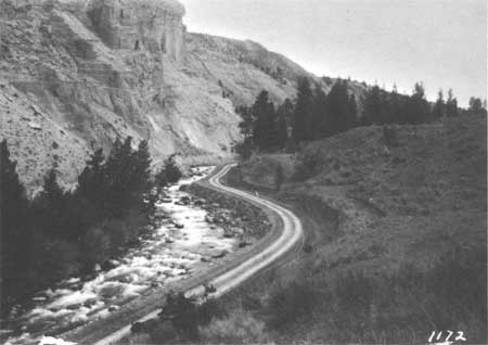
Road Through Gardner River Canyon, 1912 Courtesy Yellowstone National Park Archives |
|
|
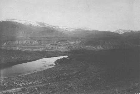
Hill Road Realignment, Gardiner to Mammoth Hot Springs, 1918 Courtesy Yellowstone National Park Archives |
|
|
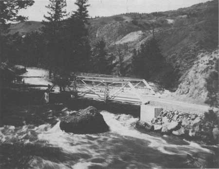
Middle Gardiner River Bridge, early 1900s Courtesy Yellowstone National Park Archives |
|
|
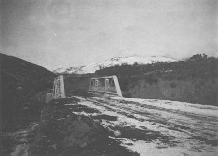
Lower Gardner River Bridge, 1905 Courtesy Yellowstone National Park Archives |
|
|
North Entrance Checking Station, 1922 Courtesy Yellowstone National Park Archives |
|
|
North Entrance Checking Station, 1936 Courtesy Yellowstone National Park Archives |
|
|
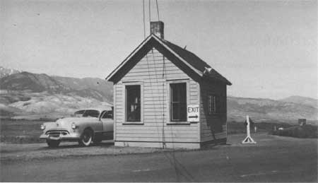
North Entrance Checking Station (Temporary), 1937 Courtesy Yellowstone National Park Archives |
|
|
North Entrance Checking Station, 1938 (Remodeled after Fire of March 1937) Courtesy Yellowstone National Park Archives |
|
|
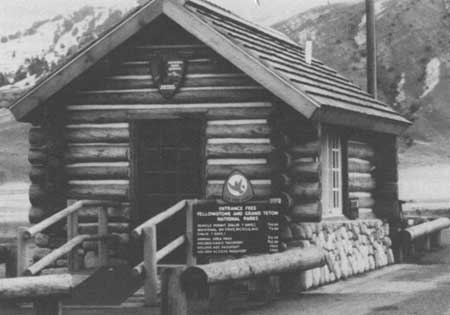
North Entrance Checking Station, 1949 Courtesy Yellowstone National Park Archives |
|
|
North Entrance Checking Station, 1990 Courtesy Yellowstone National Park Archives |
CHAPTER XIII:
ENDNOTES
1. Philetus Norris, Report Upon the Yellowstone National Park for the Year 1879 (Washington D. C.: Government Printing Office, 1880), 3-4.
2. Norris, Report Upon the Yellowstone National Park for the Year 1879.
3. Kingman Report for 1883, 11-12.
5. Report of the Secretary of War Being Part of the Messages and Documents Communicated To The Houses of Congress and The Beginning of The First Session of The Fiftieth Congress in 4 Volumes, Volume II- in fours parts, Part IV (Washington D. C.: Government Printing Office, 1889), "Annual Report of Maj. Charles J. Allen, Corps of Engineers, Officer in Charge, for the Fiscal Year Ending June 30, 1889," 2863.
6. Hiram Chittenden, Annual Report Upon the Construction, Repairs, and Maintenance of Roads and Bridges in the Yellowstone National Park and Construction of Military Roads from Fort Washakie to Mouth of Buffalo Fork of Snake River, Wyoming, and Erection of Monument to Sgt. Charles Floyd in the Charge of Hiram A. Chittenden, Captain, Corps of Engineers, Appendixes FFF and KKK of the Annual Report of the Chief of Engineers for 1904 (Washington D. C.: Government Printing Office, 1904), 2889.
7. Hiram Chittenden, Annual Report Upon the Construction, Repairs and Maintenance of Roads and Bridges in the Yellowstone National Park and Construction of Military Roads from Fort Washakie to Mouth of Buffalo Fork of Snake River, Wyoming, and Erection of Monument to Sgt. Charles Floyd in the Charge of Hiram A. Chittenden, Captain, Corps of Engineers, Appendixes GGG and KKK of the Annual Report of the Chief of Engineers for 1903 (Washington D. C.: Government Printing Office, 1903), 2890.
8. Ernest Peek, Annual Report of the Chief of Engineers for 1907 (Washington D. C.: Government Printing Office, 1907), 2468.
9. Ernest Peek, Annual Report of the Chief of Engineers for 1908 (Washington D. C.: Government Printing Office, 1908), 2547. "Report of Inspection of Bridges in the Yellowstone National Park, made September 24, 25, 26, 1909," with recommendations by request of Capt. Wildurr Willing, Corps of Engineers, U. S. A. C. H. Knight, C. W. Kutz, and Jay J. Morrow, Report Upon the Construction, Repair, and Maintenance of Roads and Bridges in the Yellowstone National Park and Report Upon the Road Into Mount Rainier National Park and Report Upon the Crater Lake National Park (Washington D. C.: Government Printing Office, 1911), 3030-3031. H. W. Child, President Yellowstone Park Transportation Company, to Acting Superintendent, Yellowstone National Park, 2 May 1912. William Nespital, "Notes on the Condition of the Old Road from Mammoth Hot Springs to Gardiner," April 10, 1912. C. W. Knight, Army Corps Engineering Officer, to Chief of Engineers, Army Corps of Engineers, 19 February 1912. Lt. Col. Brett, Superintendent, Yellowstone National Park, to Secretary of the Interior, 14 May 1912. Lt. Col. Brett, Superintendent, Yellowstone National Park, to Secretary of the Interior, 20 May 1912. "Report of Work Repairing Old Wagon Trail between Mammoth Hot Springs to Gardiner," May 27 to June 21, 1912. Lt. Col. Brett, Superintendent, Yellowstone National Park, to Secretary of the Interior, 22 June 1912. C. H. Knight, J. B. Cavanaugh, and J. J. Morrow, Report Upon the Construction, Repair, and Maintenance of Roads and Bridges in Yellowstone National Park; Report Upon the Road Into Mount Rainier National Park; and Report Upon Crater Lake National Park, Appendixes EEE and FFF (Washington D. C.: Government Printing Office, 1913), 3269-3270. "Report for November, 1915."
10. G. E. Verrill and George Zuin, Report Upon the Construction, Repair, and Maintenance of Roads and Bridges in the Yellowstone National Park; Report Upon the Road Into Mount Rainier National Park; and Report Upon Crater Lake National Park, Appendixes EEE and FFF (Washington D. C.: Government Printing Office, 1918), 1977-80.
11. Annual Report of the Director of the National Park Service to the Secretary of the Interior for the Fiscal Year Ended June 30, 1919 (Washington D. C.: Government Printing Office, 1919), 46-47.
12. Report of the Director of the National Park Service to the Secretary of the Interior for the Fiscal Year Ended June 30, 1921 (Washington D. C.: Government Printing Office, 1921), 209. Report of the Director of the National Park Service to the Secretary of the Interior for the Fiscal Year Ended June 30, 1921 and the Travel Season 1921 (Washington D. C.: Government Printing Office, 1921), 165. Report of the Director of the National Park Service to the Secretary of the Interior for the Fiscal Year Ended June 30, 1923 and the Travel Season 1923 (Washington D. C.: Government Printing Office, 1923), 116.
13. Annual Report of the Director of the National Park Service to the Secretary of the Interior for the Fiscal Year Ended June 30, 1921 and the Travel Season 1921.
14. One of the proposals was from Gilmore Clark, Landscape Architect from Westchester County, New York who developed a Mammoth Plan.
The alternative of leaving Mammoth Hot Springs at the northeast corner or through the Transportation Company Grounds and following the hillside in the vicinity of the old high-line road to Gardiner was investigated by logging with automobile and on foot with Abney, although no staked line was run. This proposed route would leave Mammoth Hot Springs from behind the two storage sheds of the Transportation and descend along the east exposed hillside on 2% and 3% grades for the first two miles. This 2 mile point would be directly above a small lake and the purpose of using light descending grades to this point is to make use of the most stable ground and cross the drainage area above the lake in the most desirable place. From this point to the North Entrance approximately 2.5 miles it is necessary to continue on a 5% descending grade as much of the distance as practicable and the line would be then fairly rough, rolling country which would require considerable curvature some of which would approach the minimum radii, a sustained 5% grade for the last 2.5 miles will reach the elevation of the North Entrance without employing development, but some of the country, particularly in the last mile, would necessitate curvature which might almost resemble switchbacks. This route is the shortest and most direct route possible between Mammoth and Gardiner. Running in approximately a due north and south direction, it lies principally on east exposure and almost entirely thru open sagebrush country. Where the line would fall on north exposure or around points with northeast exposure, it would doubtless be subject to deep snow drifts but probably of little more consequence that what would occur on the canyon route as the difference in elevation is not great. This line would pass above the treacherous unstable, shifting ground which is caused principally by seepage from the lake which was mentioned below the two mile point. This line offers the opportunity, when considered with certain alternates of the other entrances to Mammoth Hot Springs, of bringing traffic into Mammoth Hot Springs before making junction with another entrance road of connecting with Mammoth Hot Springs at the logical geographic location, thereby affording the unacquainted tourist an exit from Mammoth Hot Springs in the direction he desires to go.
"Report to Horace Albright by Gilmore Clark, June, 1930."
15. Howard Gregg, "Monthly Narrative Report to the Chief Architect," December 20, 1937 to January 20, 1938. File Box 10, Yellowstone National Park. National Archives and Records Center, Denver, Colorado.
16. Phillip Wohlbrandt, Park Engineer, "Final Report, Project No. 508, Flood Damage, Reconstruction of Mammoth-Gardiner Road, April, 21, 1943."
17. Fixed Property Records for Yellowstone National Park, National Park Service, Rocky Mountain Regional Office files, Denver, Colorado.
| <<< Previous | <<< Contents>>> | Next >>> |
hrs-roads/chap13.htm
Last Updated: 20-Apr-2016