|
YELLOWSTONE
The History of the Construction of the Road System in Yellowstone National Park, 1872-1966 Historic Resource Study, Volume I |

|
|
Part One: The History of the Construction of the Road System in Yellowstone National Park, 1827-1966 and the History of the Grand Loop and the Entrance Roads |
CHAPTER XV:
HISTORY OF EAST ENTRANCE ROAD
Appropriations for the East Entrance Road were approved June 6, 1900 and March 3, 1901, with work beginning July 1, 1901 under the direction of Capt. Hiram Chittenden. After careful inspection of the two possible routes, Jones Pass and Sylvan Pass, both of which were considered "excessively difficult", the Sylvan Pass route was chosen. Several reconnaissance surveys were made on the Sylvan Pass route finding immense physical obstacles, but Captain Chittenden favored the selection because "The pass is one of great scenic beauty and will be an important addition to the attractions of the Park." The lower elevation, by 1000 feet, of this route over the higher Jones Pass route was also factored into the selection. [1]
With the termini of the route, the outlet of Yellowstone Lake and a point where the east entrance boundary crosses the Shoshone River, predetermined, the survey proposed a route which left a point 1/4 mile below the lake outlet in a straight line over flat ground through a forested area to the Pelican Creek valley. From that point the road went along the north bank of Indian Pond (also known for a number of decades as Squaw Lake) and on the west shore of Turbid Lake, crossing over a low pass east of Lake Butte between Bear and Cub Creeks. After crossing Cub Creek, above the hot springs, the road followed the slopes of the hills that divide the Cub and Clear creek valleys. On either side of Cub Creek, the road offered very good views of Lake Yellowstone. The route then ascended the Clear Creek valley on the creeks north bank to Sylvan Lake. [2]
Chittenden described the area in his report for 1901, "This place is one of scenic attractions unsurpassed in any part of the mountains. Sylvan Lake is a small but exceedingly beautiful sheet of water near the summit of the pass, which is about 2 miles farther east". From Sylvan Lake to the Pass, the road then traverses very difficult natural conditions for the pass is very narrow. Captain Chittenden called it ". . . unique among mountain passes in that it is almost entirely loosened from the cliffs on either side by the action of frost. This broken rock varies in size from fine pebbles to pieces a cubic yard in volume." [3] From the top of the pass, the route descended on an extreme grade down into the valley of the North Fork of the Middle Creek for approximately 4 miles to the junction with the main creek. From that point the survey suggested that the route follow along the north bank of the Middle Creek to its junction with the Shoshone River, approximately 7 miles east.
Despite very difficult natural conditions such as excessively steep slopes, unstable ground, prevalent avalanche and landslides conditions, and huge boulders in the route, Captain Chittenden believed that the "scenery along the entire valley of this stream is on the highest scale of grandeur and sublimity" outweighed the obstacles.
During the first construction season, the crews cleared a swath 30 feet wide and 12.3 miles long, from the lake outlet to a point 3/4 of a mile from the Cub Creek crossing. A total of 41 acres was cleared and in most cases the timber was "taken out of sight of the roadway." The grading from the lake outlet to near Indian Pond and on to the top of a ridge south of Turbid Lake, provided a passable road 9.6 miles in length. The grading project also included the construction of a causeway across Pelican Flats, which was 1,500 feet long, 18 feet wide, and 3-1/2 feet high. An approach to the Yellowstone River, 18 feet wide and 4 feet high with cribbing to the top, was also part of the project. Some the road projects were slowed due to the crews being pulled for two weeks of fighting forest fires. [4]
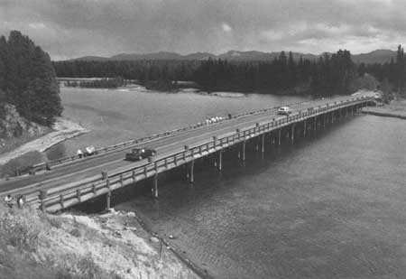
Early in the planning stage, a ferry site was chosen on the Yellowstone River, 1/4 mile from the lake outlet. Pile and timber approaches, which extended 2 feet on either side of the water line, were constructed in a position to point downstream at an angle of 3 degrees to the norm of the current. Later, construction began on a pile vent bridge, 360 feet long on earth approaches. The average penetration of the driven piles was 7 feet. In order to provide access for rowboat passage and to avert a heavy embankment on the eastern approach, the bridge's center was raised approximately 3 feet above the ends giving it a curved profile. The bridge was completed in 1902. The other substantial bridge completed that year was another pile bridge, 192 feet long over Pelican Creek. In addition to these two bridges, which Chittenden described as "plain structures", the crews, under the supervision of assistant engineer, S. F. Crecelius, built six other bridges over streams between Turbid Lake and Sylvan Pass, the longest of which crossed Cub Creek. [5]
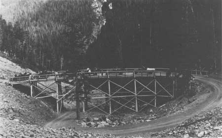
The road opened to the public on July 10, 1903, but the excessively steep slope east of Sylvan Pass remained an important piece of unfinished work. In 1905, several wooden bridges were built along the route, including one over Grinnell Creek. The following year, an 150 feet wooden viaduct was completed on the difficult section east of Sylvan Pass. Chittenden described the construction of the viaduct "by which the road down the mountain on the east side of Sylvan Pass is made to pass over itself in order to secure the necessary reduction in grade". [6]
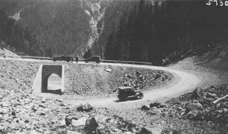
In addition to the 1909 construction of a new bridge at Turbid Lake and the construction of a 25 foot timber bridge at an unnamed location on the East Entrance Road in 1913, not much new construction was undertaken until 1916 and 1917. [7] By 1917 the wooden viaduct east of Sylvan Pass was replaced by a 60 feet span wooden bridge with a large rock fill at the west abutment. The Pelican Creek Bridge was partially refloored and many of the smaller bridges along the route received lesser repairs. Some widening and grading was done, as well as the installation of numerous galvanized-iron culverts. [8]
The Park received the first road paving appropriation for the Grand Loop in 1917, however, most of the money was returned to the general treasury as a result of the United States entry into World War I. Soon after the end of war, automobile travel to the park increased tremendously as reflected in the statistics for 1917—5,703 automobiles entered compared to 10,737 in 1919. This increase naturally would necessitate more road improvements. [9] In 1923, seven miles of road were widened and 3 miles were surfaced. [10]
During 1924 and 1925, there was much debate over the advantages and disadvantages of the Bureau of Public Roads taking over the responsibility of road improvement and road construction in the national parks. However, there was one agreement between the two groups in regards to road work in Yellowstone and that was the fact that the East Entrance Road from the Lake outlet to the East boundary would need complete reconstruction on most segments. A 1925 estimate for the reconstruction project was approximately $400,000. [11]
In 1926, the Bureau of Public Roads reached a working agreement with the National Park Service and construction of the East Entrance Road became one of the first projects under the new arrangement. As part of the agreement, the Bureau would provide all of the technical expertise and the National Park Service landscape architects would provide the design and special treatments pertaining to landscape architecture. The National Park Service and the Bureau worked closely in order for the road system including the bridges to harmonize with the natural features and surroundings.
The 1927 survey between Sylvan Pass and the Fishing Bridge suggested that the new road be relocated to take advantage of higher vistas including the Grand Teton in addition to the elimination of many sharp turns and curves. [12] During, July of 1928, the contractor, Morrison Knudsen Company of Boise, Idaho, completed different stages of clearing, grubbing, grading, and surfacing. Cement rubble headwalls were installed by a masonry crew of one stone mason and two helpers. [13] The mason's work also included the construction of the Cub Creek Bridge.
On September 2, 1928, a heavily loaded and miscalculated shot went off causing significant damage to the standing timber on the hillside and even onto the opposite side of the canyon. Immediate cleanup was ordered, but a more abiding consequence resulted with the issuance of more stringent changes to the specifications. [14] The crews finished the 1928 construction season with more cleanup, plowing portions of the old 1901 road, dressing of the borrow pits and put finishing touches at points requested by Superintendent Albright and the park landscape architect. [15]
The following construction season, blasting procedures were carried out in a safer manner and precautions were taken to both protect the passing traffic and also to try to reduce the inconvenience to the visitors. Between 7 p.m. and 7 a.m., the East Entrance gate and a barricade at Fishing Bridge were padlocked to prevent nighttime travel. During the working hours, flagmen used a signal system at potential dangerous points. Extensive settlement occurred over the winter on the completed Cub Creek section. In one case the road settled as much as 3-1/2 feet and minor sliding occurred in several places. [16] Construction work, mostly grading, drainage and some surfacing, during the 1929 season concentrated in the eastern half of the road, between Sylvan Pass and the East Entrance. The grading on the East Entrance Road was considered by the Bureau officials to be "one the heaviest, per mile, grading jobs that will be had in Yellowstone and one which involved greater traffic hazards and difficulties than will usually be expected". [17] The mason and his crew completed cement rubble masonry work on the concrete box culverts and corrugated metal pipe culverts were installed as the drainage work demanded. [18]
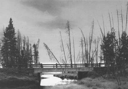
Completing the surfacing on the segment lasted for the next few construction seasons. In 1934, construction began on the new Pelican Creek Bridge and the Sedge Creek Bridge. [19] By 1935, 25.64 miles of the 26 miles East Entrance Road had been completed. The remaining section, the approaches to the Fishing Bridge were completed and opened to travel on August 1, 1937. [20] By this time, the East Entrance Road was the most heavily traveled road in the park with 50,176 vehicles using it. The second heaviest volume of traffic was on the Lake Junction to Canyon segment with 43,645 vehicles. [21]
In 1939 and 1940, the road received a 6" depth of base course surface of crushed rock and gravel and a 2" top course of dense graded plant mix bituminous surfacing with a stone chip cover coat to the width of 22 feet with 1 foot shoulders. A short realignment was made at Steamboat Point to move the existing road off a thermal area to solid ground. The crushed rock used in the surfacing material came from flattening out slopes on Sylvan Pass; the medium quality bank gravel and the good quality lake shore gravel for aggregate came from two nearby pits. The binder material, which came from a pit near Sylvan Lake, was mixed with rock from Sylvan Pass and from a roadside cut at the east entrance to the spur road for Lake Butte.
The top course, which had been stockpiled and dried, was mixed with MC-3 outback asphalt at a Madison stationary mixing plant. The mixture was then spread by a paving machine at an average temperature of 200 degrees F. and was rolled with a 7-ton roller approximately 3 hours after being spread and then again the second day. Traffic flowed on lane after the first rolling. After 4 to 5 weeks the seal coat and a final layer of stone chips were applied then rolled with a 8 to 10 ton roller. The road was opened to traffic 24 hours after the last rolling. In addition to the surfacing, new parking areas, including a very large area just west of Fishing Bridge were constructed.
The contractor, Taggert Construction Company of Cody, Wyoming, brought the equipment and supplies in from Cody, as well as obtaining the asphaltic material from Cody area refineries. No great difficulties were encountered on this two year project and no major accidents occurred. Most of the skilled labor were hired from the Cody area; in 1939, the unskilled labor were hired from the National Reemployment Service office at Mammoth Hot Springs and in 1940, from the National Reemployment Service office in Cody. The 74 men crew were based at a camp located 1/2 mile north of Fishing Bridge and used the National Park Service mess hall at Lake and the contractor's at Pelican Creek. [22]
In the spring of 1941, Wyoming Congressman John J. McIntyre requested the National Park Service consider keeping the East Entrance Road open year round. In the National Park Service acting director's negative reply, he emphasized the severe winter road conditions on that segment and the extreme high costs of keeping that section of the park open. He stated that a 1940 study examined the feasibility of keeping the park roads open during the winter, but the high costs in addition to the severe weather conditions and the small numbers of winter visitors, compelled the National Park Service to deny opening up the Park for winter travel. [23]
The United States' entry into World War II brought major road projects to a halt and it would be the MISSION 66 period before the East Entrance Road underwent any major work. Up to 1960, $2,567,000.00 had been spent on the 26.3 miles East Entrance Road and 3.9 miles of parking area. In 1961, $8,343.46 was spent on bridge work and improvement. In 1962, $42,698.84 was spent on resurfacing, replacement of 1,540 feet of guardrail and work around Indian Pond. [24]
In 1963, a location survey was completed for the segment of the East Entrance Road beginning at a point 1,000 feet west of the Sylvan Pass summit to the east boundary of the Park and also including an 850 feet connection to U. S. Highway 14 and 20 in the Shoshone National Forest. In November, 1964, the contract was awarded to Cave Construction, Inc. of Great Falls, Montana. The project, which began on July 1, 1965, began with clearing, excavating and embankment construction. The crews excavated using 966 Caterpillar front-end leaders, Euclids, dump trucks and dozers. Tractor-drawn sheepsfoot or vibratory rollers were used for compaction, with the water needed for compaction of subgrade and base course being obtained from Middle Creek by the assistance of a portable water plant and tank trucks.
The material for the base course came from a talus slope south of Sylvan Pass summit. The placement of the bituminous preservative treatment was completed on August 18, 1966. In addition to road surfacing, 4,550 lineal feet of 18-inch trench was dug for the Mountain States Telephone Company's underground cable. Corrugated metal pipes, 18 inches to 30 inches in diameter, with concrete headwalls, drop inlets and metal end sections were installed to aid surface drainage. Two of the existing culverts were enlarged by using 10' by 5'3" structural plate arch pipes. Before the project ended, some grading, realignment, widening of the existing road, construction of a new entrance station and several parking areas were completed. The engineers reported that "no unusual engineering problems" were found on this project. The total cost of the project excluding the utility work amounted to $687,935.39. The work crews, who mostly came from the area, lived in trailer houses which were sited outside of the park, near Holm Lodge.
At the conclusion of the project, the engineers recommended a surfacing contract for the reshaping and permanent surfacing of the old roadway which had received damage from the heavy construction traffic. The engineers considered the old road to be in a hazardous condition. [25] In 1968, $847,078.11 was spent on the same section of road and on 8.053 miles of parking In 1969, $2,954.77 was spent on the same section. In 1970, $348,827.02 was spent on shoulder improvements and in 1976, $631,401.02 was spent on bituminous surfacing of previously constructed section from the East Entrance to Sylvan Pass. In 1983, $132,497.00 was spent on replacing the cable guardrail and in 1987, more guardrail work was completed for an a cost of $1,906.10. Thus as of 1987, $4,422,406.76 had been spent on the East Entrance Road. Extensive repair was done to 2,430 linear feet of masonry guardrail east of Sylvan Pass. Approximately 2,290 linear feet of wooden quardrail was replaced, including the rails on the Pelican Creek and Sedge Creek Bridges. [26]
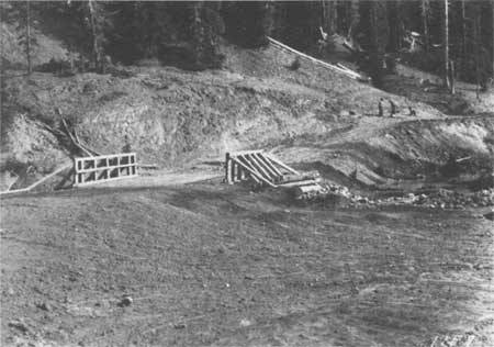
|
|
Cub Creek Bridge, ca. 1900 Courtesy Yellowstone National Park Archives |
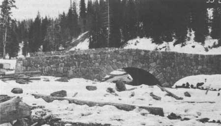
|
|
Cub Creek Bridge, 1929 Courtesy Yellowstone National Park Archives |
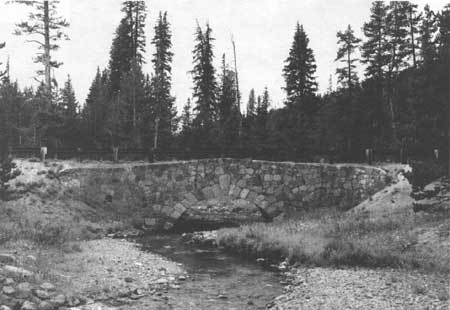
|
|
Cub Creek Bridge, 1989 Courtesy Historic American Engineering Record, Jet Lowe, 1989 |
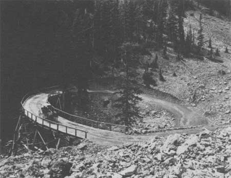
|
|
Corkscrew Bridge, 1912 Courtesy Yellowstone National Park Archives |
|
|
Corkscrew Bridge, 1917, First Cars on Wooden Structure Courtesy Yellowstone National Park Archives |
|
|
Corkscrew Bridge, 1922 Courtesy Yellowstone National Park Archives |
|
|
Fishing Bridge, 1989 Courtesy Historic American Engineering Record, Jet Lowe, 1989 |
|
|
Sedge Creek Bridge, 1989 Courtesy Historic American Engineering Record, Jet Lowe, 1989 |
|
|
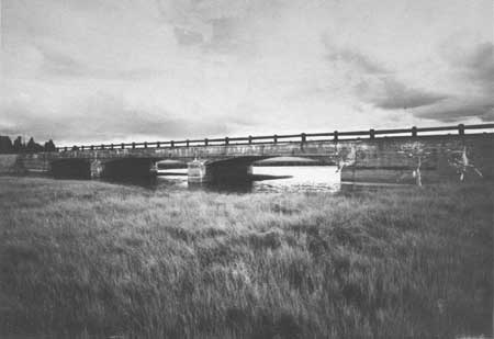
Pelican Creek Bridge, 1989 Courtesy Historic American Engineering Record, Jet Lowe, 1989 |
|
|
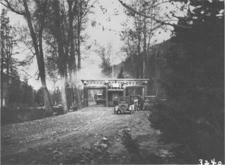
East Entrance Checking Station, 1924 Courtesy Yellowstone National Park Archives |
|
|
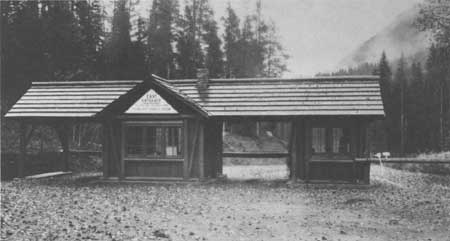
East Entrance Checking Station, 1929 Courtesy Yellowstone National Park Archives |
|
|
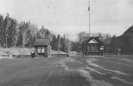
East Entrance Checking Station, 1941 Courtesy Yellowstone National Park Archives |
CHAPTER XV:
ENDNOTES
1. Hiram Chittenden, Report Upon the Construction, Repairs, and Maintenance of Roads and Bridges in the Yellowstone National Park and Construction of Military Road from Fort Washakie to Mouth of Buffalo Fork of Snake River, Wyoming and Erection of Monument to Sgt. Charles Floyd In the Charge of Hiram M. Chittenden, Captain, Corps of Engineers. Appendixes FFF, III, and JJJ of the Annual Report of Chief of Engineers for 1901 (Washington D.C.: Government Printing Office, 1901), 3794.
2. The segment of 1901 route from Turbid Lake to Sylvan Pass is roughly the same route as the designated pack trail route, —.
5. Hiram M. Chittenden, Improvement of Yellowstone National Park, Including the Construction, Repair and Maintenance of Roads and Bridges. Annual Report of the Chief of Engineers for 1902, Appendix FFF (Washington D.C.: Government Printing Office, 1902), 3035.
6. Hiram M. Chittenden, and John Mills, Annual Report Upon the Construction, Repair, and Maintenance of Roads and Bridges In the Yellowstone National Park and the Road Into Mount Rainier National Park; Survey for Wagon Road from Valdes to Fort Egbert, Alaska, and Survey for Military Trail Between Yukon River and Coldfoot, Alaska, Appendixes FFF and DDD of the Annual Report of the Chief of Engineers for 1905 (Washington D.C.: Government Printing Office, 1905), 2811.
Hiram M. Chittenden, Ernest Peek, John Mills, and Francis A. Pope, Annual Report Upon the Construction, Repair, and Maintenance of Roads and Bridges in the Yellowstone National Park and the Road Into Mount Rainier National Park, Appendixes GGG and JJJ of the Annual Report of the Chief of Engineers for 1906 (Washington D.C.: Government Printing Office, 1906), 2255.
7. Wildurr Willing and C.W. Kutz, Report Upon the Construction, Repair, and Maintenance of Roads and Bridges in the Yellowstone National Park and Report Upon the Road Into Mount Rainier National Park, Appendixes GGG and HHH (Washington D.C.: Government Printing Office, 1909), 2510.
C. H. Knight, J.B. Cavanaugh, and Jay J. Morrow, Report Upon the Construction, Repair, and Maintenance of Roads and Bridges In the Yellowstone National Park, Report Upon the Road Into Mount Rainier National Park. Report Upon Crater Lake National Park, Appendixes EEE and FFF (Washington D.C.: Government Printing Office, 1913), 3269.
8. Stephen Mather, Report of the Director of the National Park Service to the Secretary of the Interior for the Fiscal Year Ended June 30, 1917 (Washington D.C.: Government Printing Office, 1917).
9. Secretary of the Interior Franklin Lane to Senator Francis Warren, 29 January 1920. Yellowstone National Park Archives, Yellowstone National Park.
10. "Proposed Road Projects for 1923." The document had no author or exact date.
11. Horace Albright, Superintendent, Yellowstone National Park to Stephen Mather, Director of the National Park Service, 29 July 1925. Yellowstone National Park Archives, Yellowstone National Park.
12. Sheridan Post Enterprise, October 30, 1927.
13. "Monthly Narrative Report, July 31, 1928 of Yellowstone National Park, District No. 3." File Box: Roads B.P.R. Yellowstone National Park Archives. Yellowstone National Park.
14. "Monthly Narrative Report September 30, 1928, Yellowstone National Park, District No. 3." File Box: Roads B.P.R. Yellowstone National Park Archives, Yellowstone National Park.
15. "Monthly Narrative Report, September 30, 1928, Yellowstone National Park, District No. 3." File Box: Roads B.P.R. Yellowstone National Park Archives, Yellowstone National Park.
16. "Monthly Narrative Report, June 30, 1929, Yellowstone National Park, District No. 3." File Box: Roads B.P.R. Yellowstone National Park Archives, Yellowstone National Park.
17. "Monthly Narrative Report, July 31, 1930, Yellowstone National Park, District No. 3." File Box: Roads B.P.R. Yellowstone National Park Archives, Yellowstone National Park.
18. "Monthly Narrative Report, October 31, 1929, Yellowstone National Park, District No. 3." File Box: Roads. B.P.R. Yellowstone National Park Archives, Yellowstone National Park.
19. "Report to the Chief Architect through the Superintendent, Yellowstone National Park by Mr. Franklin Mattson, Landscape Architect, September 28 - October 28, 1934." Memorandum to C. Capes from Mr. Franklin Mattson, Landscape Architect, 1 August 1935. R.G. 79. Yellowstone. File Box: 10. National Archives and Records Center, Denver, Colorado.
20. E. H. Cowan, Chief Engineer. Inspector-Superintendent," Final Construction Report (1936-37) on Grand Loop 1-El, Parking Area, and East Entrance (Fishing Bridge) 5-D1, part D2, Bridge, Approaches, Surface and Secondary Roads. Yellowstone National Park, Wyoming. U. S. Bureau of Public Roads, D-3." Loose Folder. Yellowstone National Park Archives. Yellowstone National Park.
21. C. Capes, "Traffic Survey Report Intra-Park Travel Season 1937, Yellowstone National Park, Wyoming, September 20, 1937." File Box 13. Yellowstone National park Archives. Yellowstone National Park.
22. E. H. Cowan, "Final Construction Report (1939-40) on Grand Loop National Park Project 1-E1, part F1, and East Entrance National Park Project 5-D1, D2, part C, Bituminous Surfacing Yellowstone National Park, State of Wyoming, March 11, 1941." File Box: Roads: Road System Reports 1931-1943. Yellowstone National Park Archives, Yellowstone National Park.
23. Acting Director, National Park Service, A. E. Demaray to Wyoming Congressman, John J. McIntyre, 22 April 194l. Yellowstone National Park Archives, Yellowstone National Park.
24. Real Property Records for Yellowstone National Park, East Entrance Road, Rocky Mountain Regional Office, National Park Service. The records do not detail the work other than in broad terms, i.e. resurfacing, improvements, etc.
25. "Final Construction Report (1965-1966) on Yellowstone National Park Project 5(1) East Entrance Yellowstone National Park, State of Wyoming." Office of Division of Maintenance. Yellowstone National Park.
26. Real Property Records for Yellowstone National Park, East Entrance Road. "Project Summary. East Entrance Guardrail. Yellowstone National Park." Division of Maintenance, Yellowstone National Park.
| <<< Previous | <<< Contents>>> | Next >>> |
hrs-roads/chap15.htm
Last Updated: 20-Apr-2016