|
YELLOWSTONE
The History of the Construction of the Road System in Yellowstone National Park, 1872-1966 Historic Resource Study, Volume I |

|
|
Part One: The History of the Construction of the Road System in Yellowstone National Park, 1827-1966 and the History of the Grand Loop and the Entrance Roads |
CHAPTER XVI:
HISTORY OF SOUTH ENTRANCE ROAD
The idea for a South Entrance Road was first promoted by Capt. William A. Jones in his Report Upon the Reconnaissance of Northwestern Wyoming Including Yellowstone National Park Made in the Summer of 1873, but it would be the 1890s before any semblance of a road was built. [1] During the earliest years, most of the visitors arrived via the north and west entrances, but tourists began to use the South Entrance by 1890. With urging from the governor of Wyoming, a congressional appropriation of $15,000 was granted in 1892 for the construction of a road from the Upper Geyser Basin to the South boundary. [2]
By the turn of the century Army engineer Hiram Chittenden described the South Entrance Road as ". . . merely grubbed and cleared, with trees and stumps left in middle of roadway most of the distance. The whole road is in a wretched condition and a disgrace to the Government." [3] With a $20,000 appropriation, Chittenden began improvements on the stretch of road between Yellowstone Lake and the Snake River. "Good substantial bridges" were built to span the Lewis River and Crawfish Creek. [4] In 1902, 10 bridges and 40 culverts were built on the road, with the Lewis River and Crawfish Creek bridges considered the most important. The Lewis River Bridge was a 188 feet long wooden bridge resting upon crib piers and two crib abutments; the Crawfish Creek Bridge was a 42 feet long wooden bridge. [5]
The north and west entrances continued to be the most popular entries into the Park. The South Entrance Road, in 1909, was mostly used by the military personnel in their travels to and from the Snake River Soldier Station. [6]
In 1912, a road assessment was conducted to determine the suitability from an engineering standpoint of the system for the introduction of automobile traffic in the Park. The Army Corps officer, Captain Knight, concluded that it would be better if the existing system were reconstructed than creating a separate system for motorized vehicles as some had suggested. Captain Knight felt that the South Entrance Road, which was still considered to be of minor importance, needed only partial widening with "some relocations to reduce grades and the replacement of most of the wooden bridges and culverts which are generally in worn-out condition". [7]
By 1915, part of the road had been widened from 12 to 18 feet and some of the wooden bridges had been replaced. Thousands of feet of the South Entrance Road was realigned six to seven miles south of West Thumb and engineers began building 4-foot-high rock retaining walls. [8] By 1917, all but 2 miles of the road was considered improved in addition to widening, grading and realignments, 18 and 24-inch log and galvanized corrugated iron culverts were installed. [9]
In 1917, Secretary of the Interior Franklin Lane, visited the Park and after traveling on the South Entrance Road, he requested "a railing sufficient to hold cars from running over, painted or whitewashed white so as to be easily seen from either direction." He outlined other dangerous road sections on the system.
In 1918, the newly created National Park Service assumed the responsibility for road improvement and construction in Yellowstone National Park. The South Entrance Road still was not heavily traveled by tourists and was considered in fair condition, except for the need for repair to many of the smaller bridges and pole culverts and to the sections of road that were washed out due to very high freshest and excessive rainfall during the spring of 1918. [10]
Secretary of the Interior Franklin Lane reaffirmed the Army Corps of Engineers philosophy toward road construction in the Park. In his statement of National Park Policy, he addressed road construction specifically by calling for the harmonizing of roads, trails, buildings, and other improvements with the landscape, and the employment of "trained engineers who either possess the knowledge of landscape architecture or have a proper appreciation of the aesthetic value of park lands." [11]
In 1925, the old log Crawfish Creek bridge was replaced by a 54 feet steel bridge on concrete abutments. The 15 degree skew bridge, which was placed over the creek at an angle to permit the road to be straightened at the crossing, had been relocated from it original sitting over the Gardner River in 1919. [12]
In 1926, the National Park Service and the Bureau of Public Roads reached an agreement that the Bureau would survey, construct, and improve the road system in the Park. As part of the terms of the agreement, the Bureau of Public Roads would provide all of the technical expertise and the National Park Service would provide the design and special treatments pertaining to landscape architecture. The National Park Service landscape architects worked very closely with the Bureau in order for the road system, including the bridges, to harmonize with the natural features and surroundings. At that time, most of the park roads were considered unimproved and some of the roads were so narrow that they were restricted to one-way traffic. The Bureau initiated the park survey in 1926, and construction began the following year. The 1926 survey for the South Entrance Road suggested reconstruction for many stretches of the road, widening all sharp curves between West Thumb and Lewis Lake, widening the road between Lewis Lake and the Snake River Station, the replacement of the Lewis River Bridge with a concrete structure, the replacement of 12 small log bridges with concrete culverts, and the replacement of wooden culverts with metal culverts. [13]
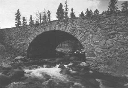
During 1930 and 1931, additional survey work was done on the South Entrance Roads, concentrating on the northern portion of the road from West Thumb to Lewis Lake. Surveys on the southern portion were done in 1932. The Lewis River Bridge site was very easily established as being very near the older bridge, but the Crawfish Creek Bridge site took extensive investigation and discussion. The design was finally approved and prepared during the winter of 1933-34. The designs for the bridges were completed by the National Park Service landscape architects—a log structure for the Lewis River Bridge and a stone-faced concrete structure for the Crawfish Creek crossing.
The newly proposed Crawfish Creek Bridge, which replaced the very narrow steel truss bridge built by the Army Engineers, and others being designed at the time, received much attention. The chief engineer of the National Park Service felt that it was ". . . worthwhile, if possible, to utilize a type of architecture that will blend harmoniously with the landscape. On the other hand, it must be realized that a bridge will always look like a bridge no matter what attempts are made to blend it into the surroundings or how much money is expended on it. This fact in many cases has been frankly conceded and steel or concrete types have been adopted. Masonry arches are of course the most desirable for most locations in National Parks, where ruggedness of landscape is the rule." [14]
By 1941, the most southerly portion of the South Entrance Road had been improved to 22-foot width bituminous surface with gravel shoulders on an originally graded 26 foot shoulder width. The northern half of the road was graded to a 28 foot shoulder width. [15] During the 1940s and 1950s, extensive surfacing projects were conducted on the South Entrance Road and the replacement of the guardrail, improved drainage and shoulders were carried out. In 1960, the log Lewis River Bridge was replaced leaving the third generation Crawfish Creek Bridge as the reminder of the collaboration of the Bureau of Public Roads engineers and the National Park Service landscape architects. In 1976, some road relocation and reconstruction was done on the South Entrance Road, including widening some sections to 30 feet shoulder to shoulder. Some work was done to drainage structures and replacement of guardrail. [16]

|
|
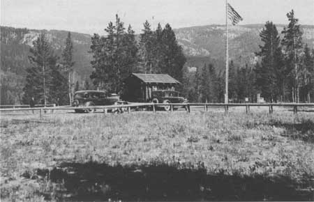
South Entrance Checking Station, 1935 Courtesy Yellowstone National Park Archives |

|
|
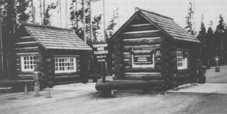
South Entrance Checking Station, 1992 Courtesy Yellowstone National Park Archives |

|
|
Crawfish Creek Bridge, 1989 Courtesy Historic American Engineering Record, Jet Lowe, 1989 |

|
|
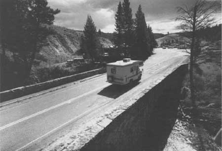
South Entrance Road over Crawfish Creek Bridge, 1989 Courtesy Historic American Engineering Record, Jet Lowe, 1989 |
CHAPTER XVI:
ENDNOTES
1. William A. Jones, Captain, Report Upon the Reconnaissance of Northwestern Wyoming Including Yellowstone National Park Made in the Summer of 1873 (Washington, D.C.: Government Printing Office, 1875), 58.
2. W. A. Jones, Major, Construction and Improvement of Roads and Bridges in Yellowstone National Park. Appendix EEE (Annual Report of the Chief of Engineers for 1892) (Washington, D.C.: Government Printing Office, 1893).
3. Hiram Chittenden, Captain, Improvement of the Yellowstone National Park, Including the Construction, Repair and Maintenance of Roads and Bridges (Annual Report of the Chief of Engineers for 1900, Appendix LLL) (Washington, D.C.: Government Printing Office, 1900).
4. Hiram Chittenden, Captain, Army Engineer Officer, to General Gillespie, Chief of the U.S. Army Corps of Engineers, 7 December 1901.
5. Hiram Chittenden, Annual Report Upon the Construction, Repair, and Maintenance of Roads and Bridges in the Yellowstone National Park, Appendixes FFF and III of the Annual Report of the Chief of Engineers for 1902 (Washington, D.C.: Government Printing Office, 1902), 3036.
6. The United States Army took over the administration of Yellowstone National Park in 1886, just three years after the Corps of Engineers assumed responsibility for road construction. A series of soldier stations were built throughout the Park for protection purposes.
7. Memorandum for all Engineers, Overseers and Foreman Under the Engineering Department, Yellowstone Park. May, 1915.
8. Lt. Col. Amos Fries and Col. George Zinn, Report Upon the Construction, Repair, and Maintenance of Roads and Bridges in the Yellowstone National Park and Report Upon Crater Lake National Park (Washington, D.C.: Government Printing Office, 1917).
9. Memorandum from Acting Director Horace Albright to Lt. Col. Amos Fries, U.S. Army Corps of Engineers, 9 October 1917.
10. Maj. G.E. Verrill and Col. George Zinn, Report Upon the Construction, Repair, and Maintenance of Roads and Bridges in the Yellowstone National Park and Report Upon Crater Lake National Park (Washington, D.C.: Government Printing Office, 1918).
11. Stephen Mather, Report of the Director of the National Park Service to the Secretary of the Interior for the Fiscal Year Ended June 30, 1918 (Washington, D.C.: Government Printing Office, 1918), 274.
12. "Annual Report of the Superintendent of Yellowstone National Park for 1925," 9.
13. Horace Albright, Superintendent of Yellowstone National Park, to J. W. Johnson, District Engineer, Bureau of Public Roads, 11 March 1926. "Tentative Suggestions for Improvements to Park Roads."
14. Frank Kittredge, "Preserving a Valuable Heritage," Civil Engineering, September 1932, 536-37.
15. Mr. B.W. Matteson, District Engineer, Public Roads Administration to Dr. L. I. Hewes, Chief, Western Region, Public Roads Administration, 9 April 1941.
16. Fixed Property Record for South Entrance Road, Yellowstone National Park, 9 September 1976. Rocky Mountain Regional Office, Yellowstone National Park.
| <<< Previous | <<< Contents>>> | Next >>> |
hrs-roads/chap16.htm
Last Updated: 20-Apr-2016