|
YELLOWSTONE
The History of the Construction of the Road System in Yellowstone National Park, 1872-1966 Historic Resource Study, Volume I |

|
|
Part One: The History of the Construction of the Road System in Yellowstone National Park, 1827-1966 and the History of the Grand Loop and the Entrance Roads |
CHAPTER II:
THE GENESIS OF NATIONAL PARK ROAD STANDARDS 1883-1890
The region embraced in the national park from its high rugged and mountainous character, presents in varied forms and combinations almost every obstacle that nature ever offered to the construction and maintenance of roads. There are steep mountains and dense forest, rocks, streams, canons, and marshes, a moist climate, and heavy snows, besides the peculiar hot spring formations which are very extensive and afford the worst road material I ever met with.
Lt. Dan Kingman, U. S. Army Corps of Enigneers
As a result of depredations on the natural features, the wanton killing of game and poor and sometimes corrupt administration in general, members of Congress and other interested citizens requested that the administration of the Park be turned over to the military. On March 3, 1883, just 11 years and 2 days after the creation of Yellowstone National Park, the first phase of military presence began in the Nation's first park. The Army Corps of Engineers arrived to take charge of the construction and improvements to the Park's road system. Three years later, the U. S. Cavalry would join the Engineers and assume the role of administrating the Park. The Sundry Civil Appropriation Act allowed $40,000 for the protection, preservation, and improvements of the Park, of which $29,000 would be used for the improvement and construction of roads and bridle trails. The balance of $11,000 would cover the fixed salaries as established by the Act. The superintendent was to receive $2,000 and each of his ten assistants was to receive $900. [85]
On August 13, 1883, 1st Lt. Dan C. Kingman, U.S. Army Corps of Engineers, escorted by 1 sergeant and 10 privates of the 6th Infantry, arrived at the Mammoth Hot Springs headquarters. The party, which departed Omaha, Nebraska, by rail on the 28th of July, came by pack horse from Beaver Canyon, Idaho, over the Targhee Pass and down the Madison Valley. Ironically, Lieutenant Kingman's commanding officer of the Department of the Platte, Maj. Gen. O. O. Howard, was the same officer who had pursued the Nez Perce Indians through the park in 1877 and had been credited with some of the initial road work over the Mary Mountain route.
Kingman, a future chief engineer of the U.S. Army, described the conditions of the park roads as "very bad, barely passable even in good weather and the bridges constructed were covered with small poles, and then even long stretches of corduroy to weary and vex the people who were obliged to travel over them." [86] He found the bridle paths were passable by horseback.
The Army officer did not place blame for the road conditions on his predecessors, but used the limited appropriations as an excuse. However, it became very evident that during the first decade of the park, where roads were concerned, quantity not quality had been the order of the day. The existing 160 miles of roads enabled the tourists to visit the main points of interest, but as a result of minimal funding and engineering experience, the roads tended to be very hilly, crooked, and cluttered with tree stumps. Trees had been cleared only enough to provide the passage of a single wagon. Improper drainage systems often left water in the middle of the road. Kingman found the sidehill cuttings "temporary in character" and generally "supported on the outside by logs and brush." [87]
Since the Park was well into its tourist season, Kingman's immediate plans were to repair the existing roads and not construct new ones. Superintendent Conger provided Kingman with enough supplies and horse teams for 15 to 20 men. The shortness of the time available prevented any contract work during 1883 and only day labor was employed. Kingman was surprised to find sufficient numbers of men of "ordinary intelligence, but somewhat fickle and restless." [88] Thus, he very quickly was able to assemble more parties, each under the supervision of a foreman. [89]
Lieutenant Kingman purchased a 30-horsepower portable steam sawmill with a 58-inch saw. The sawmill, delivered by railroad to the end of the Northern Pacific branch at Cinnabar, was positioned near Mammoth Hot Springs. Kingman's crews used burned trees from the 1882 fire in the Mammoth area. Assessing that the trees were still usable for timber for bridges and culverts, he had the crews cut 3-inch planks and dimensional lumber before worms or decay set in.
Before 1883 ended, Kingman had progressed on road repairs, but more importantly, he developed a philosophy of landscape values, which many years later would be expressed by the National Park Service's Branch of Landscape Architecture. Recognizing the difficulties, and in some cases, what seemed to be insurmountable problems, Kingman recommended to the Secretary of War and to the Secretary of the Interior that only good roads be built in the Yellowstone. [90] He felt that they should "have something of the solid, durable and substantial quality that usually characterized the works constructed by the national government."[91]
In establishing the first park road standards, Kingman recommended:
an 18 feet an 18 feet width road, well rounded up in the center, and provided with suitable side ditches and cross culverts; that all trees be removed for a width of 30 feet; that on side hill cuttings the fill be retained by a dry stone wall, and that an ample ditch be placed on the up hill side at least a rod from the road to catch the snow water and convey it to the natural water courses, and that where there are meadows or marshes that cannot be drained and must be crossed, the corduroy be replaced by a good plank road. That all culverts be of stone or 3-inch plank, and that all bridges be well constructed of good sawed lumber. [92]
Kingman expressed further concern for the appearance and quality of the park:
. . . if it ever becomes the resort of fashion, if its forests are stripped to rear mammoth hotels, if the race course, the drinking saloon and gambling table invade it; if its vallies [sic] are scarred by rail-roads, and its hills pierced by tunnels, if its purity and quiet are destroyed and broken by the noise and smoke of the locomotive, if in short a sort of Coney Island is established there, then it will cease to belong to the whole people and will be unworthy of the care and protection of the national government. [93]
From August 1883 to the end of the construction season, Kingman's crews repaired existing roads. Finding the most heavily traveled road, the Mammoth Hot Springs to the Fire Hole Basin, in the worst condition, the largest work crews reported there until heavy snows of 18 to 30 inches during the middle of October prevented continuing. This 40-mile stretch, with the exception of a 3-mile portion in the Gibbon Canyon, was widened, straightened, stones and stumps removed, and slopes reduced. Frequently spaced turnouts and a new ford was built. The existing bridges were repaired and the corduroy sections were covered with sod and earth. Work on this section cost approximately $6,300 or $170 per mile.
The work on the four-mile section of road between Gardiner and Mammoth Hot Springs cost approximately $50 or $12.50 per mile. The crews only filled the ruts and removed stumps from this section. Kingman decided that the north entrance route, which was the most heavily used entrance, was hampered by a steep hill that had to be negotiated before arriving on the plateau at Mammoth Hot Springs. The existing road had steep inclines, which often made it impossible for wagons to ascend in wet weather. Kingman recommended abandoning the route and pursuing a new one following the West Fork of the Gardner River and joining the old road about four miles from the starting point.
Kingman knew that this route, with its exceptional obstacles, would be expensive to construct and estimated that it would cost approximately $2,000 per mile, which is more than double what it would cost in other areas of the Park. During 1883, he spent $5,740 and estimated an additional $3,000 would be needed to complete the 11-mile section. Before the crews stopped for the winter, a excellent road had been constructed up to the point of the rock work. Kingman hoped to complete the entire project before the first visitors arrived the following spring. [94]
Between the Fire Hole and the Upper Geyser Basin, a 10-mile road section, Kingman built a new bridge across the West Fork of the Fire Hole River, several small bridges and stretches of corduroy sections were repaired; ruts were filled in, all for the sum of about $850 or $85 per mile. From the Fire Hole River to the Yellowstone Falls, small bridges and corduroy sections were repaired and the general maintenance of removing stumps, trees, and rocks was accomplished for approximately $75 per mile for the 28 miles. Culvert and ditch repair was completed on the Clark's Fork Road for about $12. [95]
At the end of his first year, Lieutenant Kingman sent a request for an appropriation of $110,000 for the fiscal year June 30, 1884, to June 30, 1885. [96] Kingman recognized that in selected portions of Yellowstone, the existing roads would be relocated and/or abandoned. He urged an additional sum to purchase the Baronett Bridge, as he agreed with the previous superintendents that a toll bridge should not be allowed in a national park.
Kingman felt that miners in the Clark's Fork mining area could hardly be asked to improve the road to the eastern boundary, since it was entirely within the Park. Nevertheless, the miners received all their mail, supplies, machinery, and tools over this route. Thus, Kingman sought additional funds to improve the very bad road from Yancey's to the eastern boundary near Cooke City. [97]
While Rufus Hatch, the president of Yellowstone Park Improvement Company, concurred with Lieutenant Kingman on the condition of the roads in 1883, he noted that "The conveyance of Tourists by stage coach through the Park was conducted without a single accident, notwithstanding the rugged and in many places dangerous character of the Roads . . . ." [98] In Hatch's letter to Secretary of the Interior Henry M. Teller, he urged a "sufficient appropriation" for the roads as the visitors who make the long journey to park should not be deprived of visits to the places of interest because of the roads. He announced the company would upgrade the stage and saddle horse service in the park; he hoped the roads would also be upgraded. [99]
Lieutenant Kingman remained popular with the civilian superintendents, and in December 1885, Superintendent D. W. Wear wrote to the secretary of the interior requesting that Kingman be permanently assigned to Yellowstone National Park. [100] Kingman was steadily making progress with the construction of new roads and bridges and the improvement of the older roads. Since the fall of 1883 and prior to the beginning of the construction season of 1885, Kingman had used 200,000 feet of lumber in bridge construction. [101]
Three routes, the Mammoth Hot Springs to Gardiner, via West Fork of the Gardner River, (known today as Glen Creek), Norris Geyser Basin northwards toward Beaver Lake, and the Upper Fire Hole River to the Upper Geyser Basin, received most of the attention in 1885.
Several major bridges were completed, one over the Gardner River and two over the Gibbon River.
The 4-1/2-mile Mammoth Hot Springs to Gardiner road, via Golden Gate and the West Fork of the Gardner River was completed in June 1885. Even though started in September 1883, construction time was only 7 months. Some 1,275 pounds of explosives were used and more than 1,300 shots in drilled holes were fired. As a result, 14,000 cubic yards of solid rock were excavated in addition to a large amount of broken and crushed rock. This dangerous section of road was completed without any loss of life or injury. The completion of this section reduced the route by 1-1/3 miles and travel time to many areas in the park from 2 hours to half-a-day depending on the type of wagon and load. The reduced ascent of 250 feet to Swan Lake plateau enabled loaded wagons traveling in opposite directions to now pass with relative ease. The near vertical stone walls of the canyon prevented excavation of a roadway so that a 228-foot wooden trestle carried the roadway. Lieutenant Kingman noted in his report for 1885 that the "natural stone monument at the end of the trestle" marked what "visitors have called the Golden Gate." [102]
In the Fire Hole River to Upper Geyser Basin route, Kingman constructed a new road, as the old, poorly located road would be very costly to improve. The "unnecessarily long" old road crossed a "kind of geyser swamp" in some places and crossed soils of a "black obsidian sand" in others. [103] As the road neared the Upper Geyser Basin, the alignments of the old and new roads were almost the same. The new route, which cost a total of $6,042.53, reduced the three to four hours travel time from the Marshall Hotel at the Forks of the Fire Hole River to the Upper Geyser Basin to one hour. Kingman described it as "well built" and said that the bridges and culverts had "substantial character." He further described it as "sensibly level, and as the roadbed is mostly composed of gravel that packs well, it is a very pleasant road to drive over."[104]
The first trestle bridge built in the Park crossed the Fire Hole River above Hell's Half Acre. Kingman felt that this bridge was well suited to the unusual conditions of the locality, "enormous quantity of hot water that this river received it never carried any ice, and as its discharge is remarkably uniform (there is hardly a difference of a foot between high and low water) it bears little or no drift wood." The 100-foot-long trestle bridge, costing $400, was covered with 4-inch hewed planks. [105]
Kingman established a road camp near the Norris Geyser Basin in order to begin work on the new road between Norris Geyser Basin and Beaver Lake where it would connect with the old road at the head of the lake. The poorly located old road ran in an easterly direction south of Beaver Lake, before entering the woods near Lake of the Woods, then the road climbed the very steep Green Creek Hill, crossing the Continental Divide at the junction of the rivers near Norris Junction. Due to excessive snow depths and heavy timber covering, the snow concealed the road well into May. The poor subsurface drainage caused by the heavy clay soils and the "saucer-like shape" of the pass produced "horrible conditions" for travelers. Kingman noted that it was not uncommon "to see a team lying in the mud, tangled in their harness and floundering about in almost in unextricable [sic] confusion while the drivers looked on in despair." [106] Consequently, Kingman sought a new route that would provide more exposure to the sun, better drainage, and better soil conditions. The seven miles of new road, completed by the middle of October, cost $6269.80.
Before the close of the 1885 season, the crews replaced "a long and rather unsafe structure built of poles" with a "single span King-post truss of 30-feet" combined with a causeway, over the Gibbon River near the Norris Geyser Basin. [107]
In his final report for 1885, Kingman concluded that the use of day labor and the government's purchase of their own supplies was preferable and more economical than hiring a contractor. On October 23, the Army officer left the construction and road responsibilities with a hired watchman. The watchman's primary duty was to inspect the Mammoth Hot Springs to Gardiner road, making sure that it was open for travel during the winter. Only once during the winter of 1885-1886 did he have a closure. A small landslide, which obstructed travel for a short period, had to be cleared by hired laborers at a cost of $15.39. [108]
In Lieutenant Kingman's proposals and request for appropriations for the next season's work, he added a new category, the maintenance of existing roads. With the completion of 30 miles of new road added to approximately 30 miles more of road that was "good naturally," he intended to set up a new organization of road section crews. These crews, under the supervision of "competent roadmasters," would be responsible for an 8- or 10-mile section. Their duties would be to keep the roads clear of stones, keep the surface smooth, keep the ditches and culverts open, and try to prevent ruts from forming. Kingman felt this method would maintain the good roads in an acceptable condition at a minimum cost. [109]
In order for Kingman's new maintenance function to succeed, rules and regulations needed to be imposed regarding the different types of vehicles using the Park. In addition to the coaches and carriages used for touring parties, many different types and sizes of wagons traveled on the Park roads. Kingman's major concern was the damage caused by the different sizes of tires and heavy loads. [110]
In May 1886, an order was issued requiring all wagons hauling heavy freight over the Park roads to have a minimum of four-inch tires. [111] While this order caused some inconvenience to the major concessioner, the Yellowstone Park Association, the president, Charles Gibson, wrote to the commanding officer, Capt. Moses Harris that "Individually I approve of the wide tire order." [112]
Once again, $5,000 for the purchase of the Baronett Bridge over the Yellowstone was requested. Although Kingman used the amount that the previous Superintendents had suggested, he believed it exceeded the bridge's worth, having made comparisons of the costs of recently constructed bridges. He reported that another privately built bridge had been constructed over the East Fork of the Yellowstone during the winter of 1884-1885. Even though this unsightly and unsafe bridge was not a toll bridge, it should not have been built without the permission and supervision of the engineers working in the Park.
Kingman had more than a personal interest in the welfare of the Park. He recognized the role that Yellowstone had for scientists, as well as for travelers:
I talked with none among the thousands who visited it, who did not appreciate the wisdom that dedicated the National Park to its present uses, or who doubted that the Park was destined for a great and valuable future. It is not too much to say that if the Park can be preserved as it now is, subject only to such slight changes as are necessary to secure good roads and trails through it, and proper hotels to insure the comfort of visitors, it will become in time a health and pleasure resort unequaled in the whole world. Its maintenance is of more than national importance, it is an object of direct personal interest, now and in the time to come—to travelers and scientists the world over. [113]
Capt. Clinton Sears, who replaced Dan Kingman as officer in charge of construction of roads and bridges in May of 1887, reported that the very heavy snows during the winter of 1886-87 had left the roads in poor condition, but by June 20, they were in very good condition. The high spring runoffs caused damage to some bridges and washed out some roads. Changes to the Gardner River's main channel undermined the south abutment pier of the main bridge, but E.J. Lamartine, the overseer, built a brush and gravel dam and revetment to steer the water into the old channel. The road near the lower Gardner Bridge had to be cleared of debris, the road crowned, retaining walls rebuilt, and the bridge replanked. The wooden trestle through the Golden Gate was strengthened by the placement of new timber supports and road-bearer cross beams. A log and pole temporary bridge had to be placed over Obsidian Creek at the ford due to the unusually high runoff.
During 1887, Sears proposed to complete the 12 miles of road between Norris Basin and the Grand Canyon of the Yellowstone, build a new 7-mile road from Swan Lake Flats to Beaver Lake, build a new road between Norris Basin and Gibbon Canyon, which would complete the 6-mile gap, and build a new road of approximately 10 miles, between Gibbon Canyon and the Firehole Basin. Captain Sears adhered to Captain Kingman's philosophy of building "thoroughly good roads and bridges, . . . rather than to attempt to secure a greater mileage of inferior roads. . . . The National Park is a great national trust, which should be carefully guarded and preserved, while, at the same time, made readily, safely, and cheaply accessible throughout its extent." [114]
Sears, who was replaced by Maj. Charles J. Allen in April 1888, proposed an ambitious schedule for 1888, [115] but due to lack of sufficient appropriations, little was accomplished that year. However, a new five-mile road was built from the Norris Hotel across the Gibbon Meadows connecting with the road into Gibbon Canyon, a seven-mile stretch from Obsidian Cliff northward, and the Norris Basin to Grand Canyon Road was finished. [116]
The mild winter of 1888-89 and the early spring weather enabled the road crews to begin improvement work about the middle of March in the Mammoth Hot Springs area and out in the park by April 15. Lt. William E. Craighill resumed command of the road construction and improvement work in the park in April. Using part of $25,000 appropriated in October 1888, Craighill purchased a 12-horsepower portable Nagle engine and a Brownell pony sawmill for $1,267.82. The equipment was delivered by rail to Cinnabar. The portability of the equipment reduced the cost of sawing the lumber for bridges and culverts.
Testing of the Park's white pine and red fir in a laboratory at the University of Minnesota revealed that the transverse strength for a cross section of 1-by 1-inch, and for a bearing of 12 inches, between points of support, power applied midway between the points, averaged 509 pounds for the white pine and 498 pounds for the red fir. The ultimate resistance per square inch to compression in the direction of the fiber, using tests upon blocks 7 inches long and 2-inches square, averaged 4,189 pounds for white pine and 4,973 for red fir. The preferred type of timber was red fir, which was more dense and durable and not subject to as much checking and other imperfections as was white pine. Red fir was found in the park at elevations below 6,500 feet. White pine was found all over the park. [117]
By 1889, 21 bridges had been built, including four which were considered substantial and which would meet the needs for a number of years to come. However, Lieutenant Craighill felt that eventually, as appropriations warranted, they all should be replaced with iron or stone structures.
A King and Queen post-truss with a through span of 40 feet was built over the Gardner River at the south end of Swan Lake Flats. It had a trestle span of 20 feet, a roadway width of 14 feet, and a height above low water of 6-1/2 feet. An 86-foot-long trestle bridge with a 13-foot 8-inch-width roadway between guard rails, and 5-1/2-foot height above low water, was built over the Gibbon River in the canyon. The engineers felt that a trestle bridge could be safely built because the river, which has many hot springs in its bed, would not experience ice build up. A 115-foot trestle, with a 14-foot-width roadway and 30 foot height above low water at the middle point, was built over a stream near the Yellowstone Falls. Another bridge was built near the Yellowstone Falls over Cascade Creek. This was a King and Queen post-truss, with a trestle approach of 30 feet. The span of the truss was 40 feet and the height above low water was 20 feet. [118]
By October 1889, 16 miles of new road had been built: between the Gardner River and Mammoth Hot Springs Hotel—.8 mile; in Swan Lake Flats—.9 mile; in Gibbon Canyon—2.7 miles; at the Grand Canyon—1.2 miles; on the Firehole River above the Upper Geyser Basin—3.5 miles; and on the shore of Yellowstone Lake—7.4 miles. In the improvement and construction of new roads, a mixture of gravel was added to the dark colored clay, which was found in many locales along the route of the roads. It packed well when moist. As a result of little rainfall during the summer, the roads often had several inches of fine powder or dust, which was a great nuisance to the visitors. Lieutenant Craighill recommended that the roads be covered with broken stones to help alleviate the problem.
Several construction methods changed during 1889. The 18-foot width remained the standard for level and straight sections of the road. However, widths on sharp curves were increased from 10 to 50 percent, to enable the safe passage of vehicles. The sidehill cuts, increased from 2 to 6 feet, allowed room for any accumulation to be trapped on the inner side of the road instead of reducing the width of the roadway. Dry stone walls were laid up steep hillsides. Fortunately, stone of good quality was readily available in most cases. However, Craighill found the stone in the Grand Canyon of the Yellowstone soft and unworthy as a building material. The engineering officer made an effort not to scar the landscape with unsightly borrow pits or leaving great piles of felled timber. The routine was to burn the piles if the timber could not be disposed of in any other manner. [119]
Most of the work during 1890 was in the Gibbon Canyon area and near the hotel at the Grand Canyon of the Yellowstone. Both of these projects required the construction of many retaining walls. Word reached the park in 1890 that any new road work appropriation would have a rider attached that would require the work to be done by contract. The Acting Superintendent Capt. F. A. Boutelle of the 1st Cavalry, stated in his annual report that ". . . the person who advocated that proviso must have done so very thoughtlessly, or have been ignorant of the situation." With such a short construction season and the nature of the emergency situations due to weather and topography, the use of contractors could delay the opening of the park until July. Captain Boutelle suggested that if this contract procedure should go into effect, a system for the use of day laborers needed to be included. [120]
|
|
Yellowstone National Park — 1883 Courtesy Yellowstone National Park Archives |
|
|
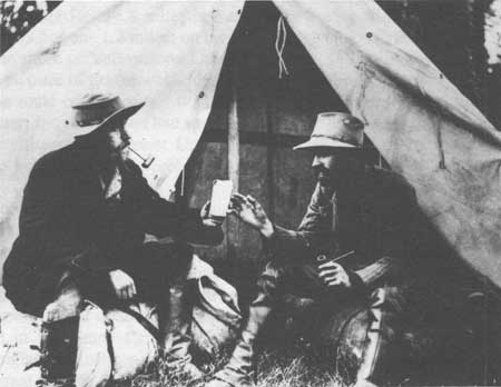
Lt. Dan Kingman, United States Corps of Engineers and Lt. R.C. Stivers,
9th Infantry, 1885 Courtesy Yellowstone National Park Archives |
|
|
United States Army Corps of Engineers at Mammoth Hot Springs, 1880s Courtesy Yellowstone National Park Archives |
|
|
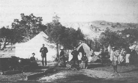
Captain Kingman (2nd from right) in camp at Mammoth Hot Springs, 1886 Photography F. J. Haynes |
CHAPTER II:
ENDNOTES
85. Secretary of the Interior, H.M. Teller to Superintendent P.H. Conger, 14 July 1883. Yellowstone National Park Archives, Yellowstone National Park.
86. Kingman did not file any reports with the Chief of Engineers, but a later Army Corps of Engineer officer, Captain Clinton B. Sears did include Kingman's notes on road improvements and construction in his report to the Chief of Engineers. See "Annual Report of Captain Clinton B. Sears, Corps of Engineers, for the Fiscal Year Ending June 30, 1887," in Report of the Secretary of War Being Part of the Messages and Documents Communicated to the Two Houses of Congress in Four Volumes (Washington D. C.: Government Printing Office, 1887).
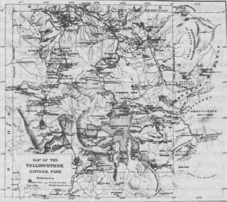
Existing roads in August 1883:
A road from western boundary to the fork of the Fire Hole River about 20 miles long.
A road from the last named point to Mammoth Hot Spring-about 40 miles.
A road from the Mammoth Hot Spring to the mouth of the Gardner River, about 4 miles.
A road from the Mammoth Hot Spring eastward via Baronetts' Bridge towards the Clark's Fork mines, about 50 miles.
A road from the forks of the Fire Hole River to the Upper Geyser Basin, about 10 miles.
A road from the same point to the Falls of the Yellowstone River about 28 miles.
And a branch from this road to the outlet of Yellowstone Lake about 8 miles.
Information regarding the road crews of 1883:
The teams ranged from 12 to 20 men under the supervision of a foreman, and each team was provided with a cook.
Pay scale: Common Laborer — $40 a month; Skilled Laborer — $50-$60 a month; Cook (according to size of party) $45-$50 a month; Foreman (according to their responsibility and knowledge required) — $50-$75 a month
Board was furnished. Daily ration for one man: fresh meat, or: 1-1/2 lbs., bacon or ham; 3/4 lb flour; 1 lb lard; 1/10 lb., potatoes; or 2 lbs onions or canned vegetables; 1 lb coffee roasted; or 2 ozs tea; 2/3 oz beans; or 3 ozs oatmeal or rice; 3 ozs canned fruits; or 1/2 lb dried fruit; 1/4 lb butter; or 3 ozs syrup; 1 gill pickles; or cheese 3 ozs condensed milk; 1/5 can baking powder; 7/100 lb salt; 01/100 lb soap; 4/100 lb candles; 2/100 lb vinegar 1/100 gallon pepper and matches. Portions were based upon the average cost of 80 cents a day for rations.
94. Ibid., 11-12. This route, though heavily timbered and covered in many places with rock and loose boulders, offered no serious obstacles to the construction of a road until the head of the canon was reached. Here for about a thousand feet, the rock walls approached each other and were nearly vertical, and the little stream in the canyon had a fall of 30 or 40 feet. Fortunately, however, the rock was of a columnar structure and there existed a natural bench, partly concealed by the talus, at about the right height, and which, by a little blasting and filling, will make an admirable road bed. 1-2.
96. Road work projects for 1884-1885.
1. Repair and improvement of existing road from Mammoth Hot Springs to boundary of park toward the terminus of the park branch of the Northern Pacific Railroad about 5 miles . . . $5,000.
2. Complete improvements of road from the Mammoth Hot Spring to Fire Hole Basin, 36 miles . . . $25,000.
3. Improvement of road from Fire Hole to Canon and Falls of Yellowstone, 28 miles . . . $2,500.
4. Improvement of road from Fire Hole Basin to upper Geyser, 10 miles, . . . $8,000.
5. Improvements of branch above route to outlet of Yellowstone Lake . . . $7,000.
6. For repairs and improvements of the road from Mammoth Hot Springs to Yancy's, 18 miles . . $1,500.
7. For constructing a new road from Yellowstone Falls via the east trail over Mt. Washburn to Yancy's, 20 miles . . . $25,000.
98. Rufus Hatch to Secretary of the Interior H. M. Teller, 1 December 1883. Yellowstone National Park Archives, Yellowstone National Park.
100. Superintendent D.W. Wear to Secretary of the Interior Teller, 3 December 1885. Yellowstone National Park Archives, Yellowstone National Park.
101. Lt. Dan Kingman to Secretary of Interior Teller, 25 March 1885. Yellowstone National Park Archives, Yellowstone National Park.
102. Lee H. Whittlesey, Yellowstone Place Names, states that, Lt. Dan Kingman, Oscar Swanson, or Ed Lamartine (the road bosses in charge of the project) probably named the canyon when they were building the first stagecoach road through Glen Creek in 1883-1884. The canyon could also have been named by park tour operator G.C. Henderson, who reported on the construction project in 1884:
To avoid the terrible hill on the only possible route from Mammoth Hot Springs to the upper districts of the park, the government has begun a road along the west fork of the Gardner River (Glen Creek) . . . When complete, this new route — the Golden Gate — will present an easy round and one that will be accessible fully two weeks earlier than that over the mountain [present day Snow Pass] up which the road now leads. (Livingston Enterprise, August 6, 1884.) Lee H. Whittlesey, Yellowstone Place Names (Helena, Montana: Montana Historical Society Press, 1988).
110. Ibid., Kingman's proposed regulations:
1. That all wagons used for the transportation of freight within the limits of the National Park shall be equipped with tires not less than 3 inches wide, and that such wagons be allowed to carry a net load of less than 3,000 pounds.
2. That for the net load of 3,000 pounds and less than 4,000 pounds, wagons shall be provided with four-inch tires.
3. That for all loads of 4,000 pounds net and upwards, they shall use 5-inch tires.
4. That it be made the duty of the Superintendent and his assistants to strictly enforce the rules.
111. Acting Secretary of Interior, H.S. Muldrow, to Superintendent, Yellowstone National Park, 25 May 1886. Yellowstone National Park Archives, Yellowstone National Park.
112. Charles Gibson to Captain Moses Harris, 23 August 1886. Yellowstone National Park Archives, Yellowstone National Park.
114. Report of the Secretary of War Being Part of the Messages and Documents Communicated to the Two Houses of Congress in Four Volumes (Washington, D.C.: Government Printing Office, 1887), Appendix AAA, "Annual Report of Captain Clinton B. Sears, Corps of Engineers, for the Fiscal Year Ending June 30, 1887," 3138-3139.
The traveled wagon roads in the Park in 1887 were as follows:
1. A road from the town of Gardiner, on the northern border of the Park, to the Upper Geyser Basin, a distance of about 50 miles. The graded portions of this road are in extent as follows: From Gardiner, via Mammoth Hot Springs, to near Swan Lake, about 10 miles. From Willow Park to the Norris Geyser Basin about 10 miles. From Gibbon Meadows to the head of Gibbon Canon [sic] about 6 miles. From the Lower Geyser Basin to the Upper Geyser Basin, 9-3/4 miles. The portion of this road not yet graded is in fair condition and perfectly safe for travel, a considerable amount of labor having been expended upon it yearly for repairs.
2. A road from the Norris Geyser Basin via the Grand Canon [sic] and Falls of the Yellowstone to Lake Outlet, about 27 miles. This road is graded for a distance of about 8 miles from the Norris Basin. The remainder of the road is in fair condition at this date. The portion of the road between the Falls and the lake is not ordinarily in condition for travel before about the middle of July, the altitude being such as to prevent the early melting of the snow.
3. A road diverging from the road to the Lake in Hayden Valley, about 8 miles from the Falls and extending to the Lower Geyser Basin, via Mary's Lake and Nez Perce Creek. The distance from the Falls of the Yellowstone to the Lower Geyser Basin by this route is about 32 miles. The road is ungraded, but in fair condition, being an excellent natural road with the exception of a somewhat precipitous descent from the plateau between the waters of the Madison and Yellowstone, on its western slope. This road from its altitude is seldom open for travel before the middle of July.
4. A road from the Lower Geyser Basin to the western border of the Park about 20 miles. This road extends beyond the Park limits to Beaver Canon [sic] Station, a stage line from that point bringing visitors to the Park at the Lower Geyser Basin. This is a fair mountain road and safe for travel.
5. A road diverging from the main Park road near Mammoth Hot Springs and extending via the canon [sic] of the East Gardner River, Baronett's Bridge, and Soda Creek, to the northeastern corner of the Park, about 55 miles, and to Cooke City, some 5 miles farther on. This road, over which all supplies for the mining camp of Cooke City are freighted, is through a rough and hilly country and throughout the greater portion of its extent is unimproved. Some slight grades have been made where it was absolutely necessary, and a few crude bridges constructed. The road has been chiefly built and kept in repair by private enterprise and is by far the worst road in the Park, being well nigh impassable a large portion of the year. Toll is very properly charged at Baronett's Bridge, as it could not otherwise be kept in repair by private means. The bridge across the Lamar River is in a very dilapidated condition and will probably not last more than a year or two longer. It would seem to be eminently proper that this road, within the Park limits, should be taken in charge by the Government, the Baronett's Bridge claim extinguished, and the road kept in proper and safe condition for travel.
115. Sears Report, 1887, 3140.
1. build a new road from Upper Geyser Basin to mouth of Yellowstone River via the west arm of the Lake
2. improve and complete the rough 14 mile road from Lake Yellowstone along the river to Grand Canyon
3. build a new 20 mile road from Grand Canyon to Yancy's
4. improve and complete an 18 mile road from Yancy's to Mammoth Hot Springs
116. Capt. Moses Harris, Annual Report of the Superintendent of Yellowstone National Park for the Year 1888 (Washington D.C.: Government Printing Office, 1888), 7 and 12.
117. Report of the Secretary of War Being Part of The Messages and Documents Communicated to The Houses of Congress and The Beginning of The First Session of The Fiftieth Congress in 4 Volumes, Volume II- in four parts, Part IV (Washington, D.C.: Government Printing Office, 1889), "Annual Report of Major Charles J. Allen, Corps of Engineers, Officer in Charge, for the Fiscal Year Ending June 30, 1889," 2857-2859.
118. "Annual Report, 1889," 2863. Bridges in the park by 1889:
1. Three spans of 33 feet over Gardner River. No truss.
2. Three spans of 32 feet over Gardner River King post.
3. One span of 28 feet, a coulee. No truss.
4. Trestle of 224 feet. Kingman's Pass. [Golden Gate]
5. One span of 14 feet over West Gardner. No truss.
6. One span of 12 feet over a slough. No truss.
7. Two spans of 40 feet and 20 feet over Gardner River. King and Queen truss.
8. One span of 32 feet over Obsidian Creek. King post.
9. One span of 16 feet over Obsidian Creek. No truss.
10. One span of 32 feet over Obsidian Creek. King post.
11. One span of 34 feet over Gibbon. King post.
12. One span of 20 feet over slough at Norris. No truss.
13. Two spans of 40 feet over Gibbon. Queen post.
14. Trestle 75 feet long over Gibbon River. Queen post.
15. One span of 38 feet over Firehole River. No truss.
16. Trestle of 66 feet over Firehole River.
17. Two spans of 36 feet over Firehole River. No truss.
18. One span of 24 feet over Gibbon River. No truss.
19. One span of 20 feet over Gibbon River. No truss.
20. Trestle 115 feet long near Yellowstone Falls.
21. One span of 40 feet over Cascade Creek. King and Queen post.
Number of culverts built 100
Linear feet of parapets and railings 1,000
120. Captain F. A. Boutelle, Report of the Superintendent of Yellowstone National Park (Washington: Government Printing Office, 1890), 8 and 9.
| <<< Previous | <<< Contents>>> | Next >>> |
hrs-roads/chap2.htm
Last Updated: 20-Apr-2016