|
YUKON-CHARLEY RIVERS
Yukon Frontiers Historic Resource Study of the Proposed Yukon-Charley National River |

|
I. THE SETTING
"Stand at Cumberland Gap," historian Frederick Jackson Turner declared in 1893, "and watch the procession of civilization, marching single file—the buffalo following the trail to the salt springs, the Indian, the fur-trader and hunter, the cattle-raiser, the pioneer farmer—and the frontier has passed by. Stand at South Pass in the Rockies a century later and see the same procession with wider intervals between." [1] Stand at the Yukon River near the Canadian border fifty years later and watch Turner's frontiers flow past modified by Alaska's unique environment: the Indian, the explorer, the trader, the missionary, the miner, the soldier, the riverboat man, the dog-team driver, the woodchopper, the homesteader, and finally the townsman.
Although never so orderly a procession as Turner describes passed through either Cumberland Gap or South Pass, his idea of moving and changing frontiers resulting in the Americanization of men and institutions has withstood the test of time and the attacks of revisionist historians. [2] By 1893 Turner had rejected contemporary historical concepts that ignored environmental factors. Instead he felt that the distinctive environment of the United States, especially the presence of free land on the western edge of advancing settlements, explained the basic American character and institutions. Attracted by dreams of economic improvement or adventure, people took into the wilderness established political, economic, and social practices. Against the hostility of a new environment these sophisticated practices gave way to new or adapted ways of life. Slowly the frontier grew more and more complex as various groups with different skills and abilities passed through, and finally a fully developed society evolved. This society, however, differed from those farther east by its separate evolution and its unique social environment. Though with essential differences because of time, place, and men, this same process repeated itself for three and a half centuries.
Alaska offered the last promise of free land and is even called the last frontier. Here exploration had barely commenced in 1890 when the Superintendent of Census declared that the frontier had passed. Turner, the historical generalist, undoubtedly did not recognize the rare opportunity presented by the vast laboratory of Alaska to test his frontier hypothesis. But Alaska in fact completes his scenario. In particular, the Yukon-Charley area, approximately two million acres around the junction of the two rivers, affords a lens through which the succession of Turnerian frontiers that made their way from Cumberland Gap to South Pass may be viewed extending to Alaska.
Like any frontier, the Yukon-Charley environment provided a decisive influence in the moulding, adapting, and inventing of social institutions. This environment, as the institutions arising from it, evolved through millions of years of uplift, erosion, and deposition. Important events in geologic time created a significant impact on man in historic time.
Throughout geologic time the earth's crust was forever in motion, buckling, fracturing, pulsating, and producing uplift and troughs as ancient seas and later glaciers emerged and submerged the land. [3] More than 520 million years ago the oldest rock in Alaska, the Birch Creek schist, formed under the sea as sediment. Later folding and intrusive lavas caused hardening and recrystallization while uplift, erosion, and primeval rivers cut into the ancient rock. At some time in the early Paleozoic era, 360 to 520 million years ago, a land mass near the upper Yukon River emerged from the sea only to be eroded and submerged again. Later an epoch of widespread vulcanism occurred under the ancient sea. For the next 200 million years mountain-building, erosion, and deposition fluctuated and changed the landscape, creating varied layers of strata. During the middle of the Jurassic period of the Mesozoic era, about 140 million years ago, great bodies of granite intruded into the previously laid sedimentary, limestone, and igneous rock. These intrusions produced uplift but, more important, brought recrystallization and metamorphism of the invaded rocks and generally formed valuable mineral deposits. The sea once again reclaimed most of interior Alaska.
|
|
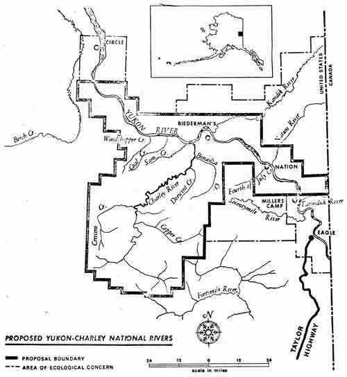
MAP 1. THE YUKON-CHARLEY PROPOSAL AREA. From the Department of the
Interior's Final Environmental Statement on Proposed Yukon-Charley
National Rivers Alaska (click on image for a PDF version) |
At the end of the Mesozoic era, 60 to 130 million years ago, with the dying out of the igneous activity came an all-important event—the injection of gold-bearing quartz veins accompanied by folding and faulting. [4] The Tintina fault, a major factor in the mineralization of Yukon-Charley, created a natural weakness or stress point that attracted the gold-bearing intrusions. During the early Tertiary period, 40 to 60 million years ago, great elevations took place, and Alaska arose from the sea with much of its present outline. Rivers and streams eroded the strata including the mineralized intrusive rocks and resulted in the development of ancient placers that in turn consolidated into conglomerate rock. At this time coal deposits were also laid down as vegetable matter in the rivers and lakes. Slowly the climate that had been subtropical began to cool. Erosion rounded mountains and created valleys of accumulated sediment. Ancient rivers flowed seeking the path of least resistence carrying in their torrent small particles of liberated gold. By the close of the Tertiary and throughout the Pleistocene, giant glaciers, originating in the mountains, waxed and waned, generally leaving the Yukon Valley free of ice and the ancient placers undisturbed.
During the last glaciation, the Yukon River remained an ice-free corridor across Alaska. As glaciers absorbed the earth's sea and the sea level dropped, a wide land bridge between Alaska and Siberia emerged. Early man and other mammals may have crossed this bridge and migrated to America along the Yukon Valley toward the United States and Mexico. [5] Following the last glacier, abrupt environmental changes caused the extinction of many of early man's food sources, such as the mastodon and musk oxen. Early man continued to adapt and change along with his environment. [6] The Yukon, whose waters and tributaries had carried away the melting glacier water, dwindled in size as the Charley, one of its largest tributaries, continued to drain the upper highland of the annual ice and snow.
As geologic time approached historic time, the environment known to the early Indian proved not dissimilar to that known to the twentieth-century Yukon trapper. The glacier-scraped highlands of the upper Charley River dominate a horizon that gently slopes down to the rounded hills, even-topped ridges, and open valleys of the Yukon Valley. The Yukon itself has cut through complex geologic structures as it flows toward the Bering Sea, leaving behind benches and terraces as testimony to its previous course and might. From a single dominant channel, often confined by resistant time-hardened rock, it breaks free upon entering the flat plains two hundred miles from the Canadian border and branches into several meandering channels. Willow, alder, and black "scrub" spruce cover its banks. As the elevation increases, the black spruce gives way to groves of white spruce, birch, and aspen. Berries of all kinds, rose bushes, and muskeg form the undergrowth.
|
|
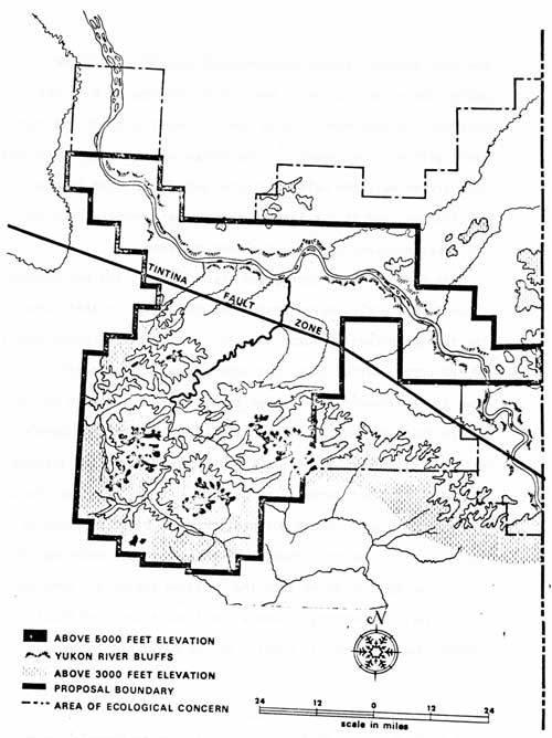
MAP 2. YUKON-CHARLEY TOPOGRAPHY From the Department of the Interior's
Final Environmental Statement on Proposed Yukon-Charley National
Rivers Alaska (click on image for a PDF version) |
But the influence that most severely distinguishes the Yukon-Charley frontier from the Cumberland Gap and South Pass frontiers of Turner is the climate. Temperatures range from seventy degrees below zero in the winter to more than ninety degrees in the summer. Sheltered by the Brooks Range to the north and the Alaska Range to the south, the Yukon-Charley area annually averages only ten to twelve inches of precipitation, comparable to the southwestern deserts. Snow cover lasts at least seven months a year while sunlight wanes to less than three hours. The impact of this climate demanded modified behavior patterns, new skills and abilities, and innovative social institutions. Even so, there as with Turner's more temperate environments, the frontier story began with the Indian.
| <<< Previous | <<< Contents>>> | Next >>> |
yuch/grauman/chap1.htm
Last Updated: 29-Feb-2012