|
National Park Service
Confinement and Ethnicity An Overview of World War II Japanese American Relocation Sites |

|
Chapter 8
Manzanar Relocation Center
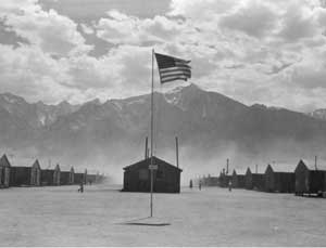 Figure 8.1. Manzanar with Mount Williamson in the background. (Dorothea Lange photograph, National Archives) |
The Manzanar Relocation Center was in east-central California, in southern Owens Valley. Located for the most part on the west side of U.S. Highway 395, it is 220 miles north of Los Angeles and 250 miles south of Reno, between the towns of Lone Pine and Independence. The central portion of the relocation center site is now a National Historic Site administered by the National Park Service. Outlying portions of the relocation center are on city of Los Angeles land administered by the Department of Water and Power and public land administered by the Bureau of Land Management.
On the western edge of the Basin and Range province, the topography of the area is dramatic, with the steep Sierra Nevada to the west and the White-Inyo Range to the east. Mount Williamson, the second highest peak in the Sierra Nevada at 14,375 feet, is 10 miles southwest. The National Historic Site itself is located where the Sierran bajada meets the valley floor at 3900 feet elevation.
The Owens Valley is in the rainshadow formed by the Sierra Nevada. Independence has a mean annual precipitation of just under 5 inches and Lone Pine approximately 6 inches. However, the valley is well-watered by Sierran streams and the relocation center site is located between two perennial streams which flow east from the Sierra Nevada, Shepherd Creek on the north and George Creek on the south. The stream flow of Bairs Creek, which crosses the southwest corner of the relocation center central area, is intermittent.
Summers are hot and winters cold, and the natural vegetation in the vicinity is desert scrub (for example, rabbitbrush and sagebrush). Non-native trees, mostly black locust, cottonwood, tamarisk, and fruit trees from abandoned ranches, farms, and the relocation center, form a band across the site.
The Manzanar Relocation Center, established as the Owens Valley Reception Center, was first run by the U.S. Army's Wartime Civilian Control Administration (WCCA). It later became the first relocation center to be operated by the War Relocation Authority (WRA). The center was located at the former farm and orchard community of Manzanar. Founded in 1910, the town was abandoned when the city of Los Angeles purchased the land in the late 1920s for its water rights. The Los Angeles aqueduct, which carries Owens Valley water to Los Angeles, is a mile east of Manzanar.
Begun in March of 1942, the relocation center was built by Los Angeles contractor Griffith and Company. Construction proceeded 10 hours a day 7 days a week; major construction was completed within six weeks. On March 21 the first 82 Japanese Americans made the 220-mile trip by bus from Los Angeles. More volunteers soon followed to help build the relocation center: over the next few days 146 more Japanese Americans arrived in 140 cars and trucks under military escort (Figure 8.2). Another 500 Japanese Americans, mostly older men, arrived from Los Angeles by train. By mid April, up to 1,000 Japanese Americans were arriving at Manzanar a day and by mid May Manzanar had a population of over 7,000 (Figure 8.3). By July Manzanar's population was nearly 10,000. Over 90 percent of the evacuees were from the Los Angeles area; others were from Stockton, California, and Bainbridge Island, Washington.
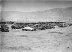 Figure 8.2. Confiscated evacuee automobiles. (Clem Albers photograph, Bancroft Library, University of California, Berkeley) |
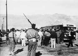 Figure 8.3. Evacuees arriving at Manzanar. (WRA photograph, National Archives) |
The central developed portion of the relocation center covers an area of approximately 540 acres (Figure 8.4). Eight watchtowers were completed on the perimeter by August 1942, and a five-strand barbed wire fence around the central area was completed by the end of the year. A military police compound with 13 buildings was located beyond the southeast quarter of the relocation center central area, south of Bairs Creek and west of U.S. Highway 395.
 Figure 8.4. Manzanar Relocation Center. (click image for larger size (~60K) ) |
Paved or oiled roads divided the central portion of the relocation center into 67 blocks, including 36 residential blocks, two staff housing blocks, an administrative block, two warehouse blocks, a garage block, and a hospital block (Figure 8.5). The 24 remaining blocks, located throughout the center, served as firebreaks. East-west roads were designated by numbers starting with 1st street at the relocation center entrance and proceeding north. The one road south of 1st Street was named Manzanar Street. North-south roads were designated by letters, starting with "A" street on the east and ending with "I" Street on the west. The evacuee residential blocks were designated 1 through 36; none of the other blocks were designated by number. The relocation center was aligned with U.S. Highway 395, rather than true north.
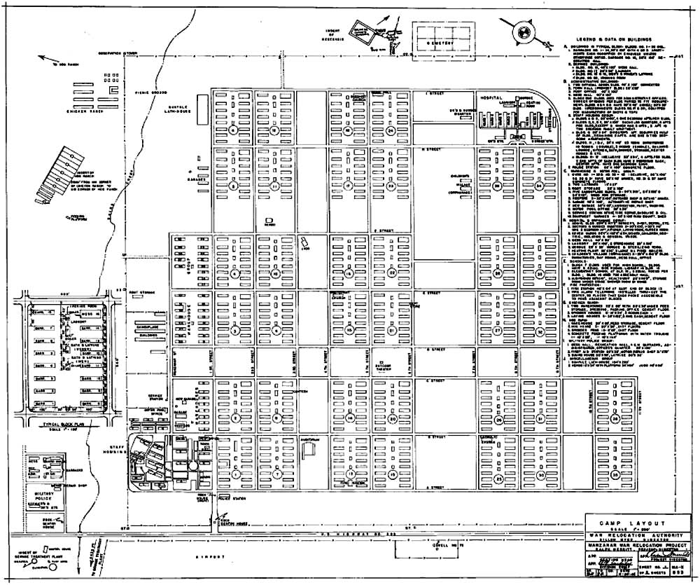 Figure 8.5. Manzanar Relocation Center central area. (National Archives) (click image for larger size) |
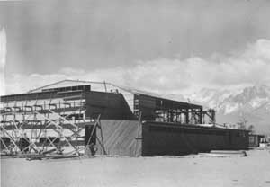 Figure 8.6. Auditorium under construction. (WRA photograph, National Archives) |
After initial construction, all additional buildings at Manzanar were completed using paid evacuee labor. Major undertakings included construction of 18 residential buildings for staff personnel; construction of an auditorium (Figure 8.6); and the construction of chicken and hog farms. Other new construction included a laundry in the staff housing area, a sentry post and police post at the relocation center entrance, a entry post at the military police compound, and a residence for the chief medical officer and appointed nurses at the hospital. In the warehouse area a root cellar, two latrines, and a garage were constructed. Also built by evacuees were a garbage can washing rack and incinerator near the hospital, a dehydration plant, Judo and Kendo buildings, a lath house, three orphanage buildings, and two outdoor theaters.
The administration block was at the relocation center entrance on the south side of 1st Street. It included nine buildings: an L-shaped office building, a town hall, a post office, a mess hall, and five staff apartment buildings. To the south of the administration block there was additional staff housing consisting of 14 apartment buildings, three dormitories, and a laundry.
West of the administration block was a garage block, a fire break, and two warehouse blocks. Buildings in the garage block included two automotive repair shops, a refrigerated warehouse, and eight other warehouses. The warehouse blocks had 29 warehouses and two latrines. A motor pool, including a service station, gasoline pump, the motor pool office, and a small unnamed structure, was south of the garage block. Four garages and a latrine were located southwest of the warehouse blocks.
Factories were located on the south side of the relocation center between the warehouse blocks and the perimeter security fence. The WRA intended the primary work at Manzanar to be industrial rather than agricultural. However, complaints from labor unions over unfair competition soon forced the WRA to limit industrial production to items slated for internal use. The chief industrial projects at Manzanar included a garment factory, a mattress factory, a food processing unit, and a short-lived camouflage net factory. Other smaller-scale industries included a furniture shop, an alterations shop, a typewriter repair shop, a sign shop, and a domestic sewing machine repair shop.
The garment factory, the first industrial project to get underway at Manzanar, was started in May 1942 in the Block 2 ironing room by ten women with a borrowed portable sewing machine. The factory was later relocated to two warehouses, where 38 industrial machines replaced borrowed domestic machines.
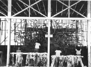 Figure 8.7. Camouflage net factory at Manzanar. (WRA photograph, National Archives) |
The camouflage net factory was run by the Southern California Glass Company under contract with the U.S. Army. The camouflage net factory included three buildings 300 feet by 24 feet by 18 feet tall for net garnishing, a 24-foot-by-100 foot enclosed shed with an attached 60-foot-by-100-foot open shed for net cutting, and a 24 -foot-by-150-foot shed for storage. Two of the net garnishing buildings had 12 foot by 20 foot additions. Net production began in June 1942 (Figure 8.7). The net factory was a major source of conflict within the relocation center, because its employees received higher wages than all other Manzanar workers and only U.S. citizens could work there.
The easternmost building of the camouflage net factory complex (the 24-foot-by-150-foot storage shed) was remodeled by the WRA for use as a mattress factory. The factory was destroyed by a fire in 1943. During its operation the factory employed a crew of 19, and produced 4,020 mattresses. The dehydration plant was a 24-foot-by-100-foot building. West of the factories there was a 26-foot-by-100-foot root storage building.
The relocation center hospital was in the northwest corner of the central area, west of evacuee residential blocks 29 and 34. It included an administration building, a doctors' quarters, a nurses' quarters, seven wards, a mess hall, a laundry, a heating plant, and a morgue, all connected by covered wooden walkways. An apartment building for Caucasian hospital staff was built using evacuee labor in a firebreak south of the hospital.
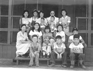 Figure 8.8. Manzanar Children's Village. (Dorothea Lange photograph, Bancroft Library, University of California, Berkeley) |
All Japanese American orphans in the restricted zone, even half-Japanese babies living in Caucasian foster homes, were sent to Manzanar. An orphanage, called Children's Village, was located near the hospital in the firebreak east of Block 29. Since the barracks provided for the evacuees were unsuitable for young children, three new one-story buildings with running water, baths, and toilets were completed in June 1942 by the evacuees. One building contained an office, superintendent's apartment, a recreation room, a kitchen, and a dining room. Another was divided into three wards: a nursery, a small children's dormitory, and a girl's dormitory. The third building was also partitioned to form three sections: a dormitory for small boys, another for older boys, and a storeroom. Over 100 children would eventually be housed at the Children's Village (Figure 8.8).
Each of the 36 evacuee residential blocks contained fourteen 20-foot-by-100-foot barracks, a mess hall, a recreation hall, two communal bathhouses, a laundry room, an ironing room, and a heating oil storage tank. The only exception was at Block 33, which lacked a recreation building. All of the buildings were constructed of wood frame, board, and tarpaper. Foundations for the barracks, mess halls, and community buildings were concrete footing blocks set at 10 foot intervals (post and pier). Foundations of the bathhouses, laundry rooms, and ironing rooms were concrete slabs.
 Figure 8.9. Barracks landscaping. (WRA photograph, National Archives) |
Although the barracks buildings and block layout were standardized, the evacuees personalized their surroundings by adding sidewalks, entries, rock-lined pathways, gardens, and small ponds (Figure 8.9). Some evacuees hand-dug basements under their barracks. Many of the residential blocks also had large community pond and garden complexes. Nearly every residential block also had its own volleyball court, a majority had basketball courts, and some had playground equipment.
The barracks and recreation buildings were also used for churches, a general store, a sporting goods store, a canteen, gift shops, a beauty parlor, a barber shop, a dressmaking shop, a shoe repair shop, a watch repair shop, a flower shop, a mail order counter, a laundry, and after April 1943 a photography studio. Block 1, at the relocation center entrance, was used for community offices and bachelors' apartments. The laundry and ironing buildings were interconnected and used for the manufacture of shoyu and tofu. All of Block 7 and the mess hall, ironing room, and one barracks of Block 2 were used for a high school. An auditorium was built by the evacuees in the fire break north of the high school. Block 16, in the central portion of the residential area, was used for elementary schools and a community center. A fire station was in a specially built building on the east side of Block 13.
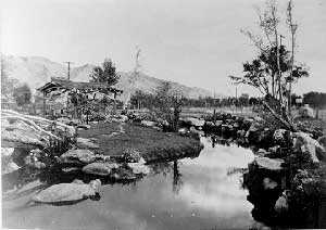 Figure 8.10. Pleasure Park. (Ansel Adams photograph, Library of Congress) |
Major developed recreation areas included a picnic area with walkways, bridges, open-air fireplaces, and a nine-hole golf course at Bairs Creek and several other community parks. Rose Park (later renamed Pleasure Park and then Merritt Park in honor of the relocation center director) was located in the firebreak between Blocks 33 and 23. It was begun in the fall of 1942 with domestic rose buds grafted to native root stock. Eventually, it included over 100 species of flowers, two small lakes, a waterfall, a bridge, a Japanese tea house, a Dutch oven, and pine trees (Figure 8.10). Cherry Park, south of the Children's Village, was begun when a nursery wholesaler donated 1,000 cherry and wisteria trees. Holes were dug at the park for swimming pools, but due to water shortages and LADWP concerns over contamination to the Los Angeles Aqueduct, they were instead seeded with grass. North Park was located between Block 32 and the perimeter security fence. It included two rock fireplaces in a grove of large cottonwoods that remained from an old ranch. Two parks were located outside the perimeter security fence, 1/4 mile and 1 mile south of the residential area. The "South Parks" opened in early 1943 under a permit system, as restrictions were relaxed and the evacuees were allowed to leave the central area.
Sports facilities included football fields and baseball diamonds in many of the firebreaks. A Judo building was constructed in the firebreak between Blocks 10 and 16 and a raised wooden platform for Kendo was built in the firebreak between Blocks 10 and 11. Outdoor theaters were located in the southwest corner of the relocation center and in the firebreak between Blocks 20 and 21.
Within several firebreaks and the cleared area between the evacuee housing and the perimeter security fence there were victory gardens divided off into individual plots of varying sizes (Figure 8.11). Evacuees also coaxed thousands of dollars worth of fruit from the hundreds of apple and pear trees that had been neglected since the town of Manzanar was abandoned. Some Manzanar evacuees conducted experiments supported by the California Institute of Technology on extracting rubber, needed for the war effort, from guayule, a small woody shrub native to the southwestern United States (Figure 8.12). Other rare plants were also cultivated to help offset war-related shortages.
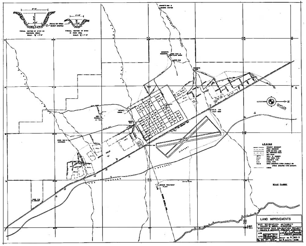 Figure 8.13. Farm fields and irrigation ditches at the Manzanar Relocation Center. (National Archives) (click image for larger size) |
 Figure 8.15. Relocation center farm field. (Dorothea Lange photograph, Bancroft Library, University of California, Berkeley) |
Large-scale farming took place outside the fenced central area (Figures 8.13-8.15). As early as April 1942 evacuees cleared a 120-acre field south of the residential area, reconditioned eight miles of old ditch, and dug two miles of new canal. In 1943, an additional 320 acres were cleared for farming, and a new system of lined ditches and pipelines was constructed. Dams were built on Shepherd and George Creeks and to supplement the stream diversions old wells were reconditioned and used.
An evacuee-constructed chicken farm was completed December 31, 1943. Located just outside the southwest corner of the fenced central area, it included a combination office, egg and feed storage, and slaughter house, 48 hen houses, 16 brooder houses, and an incinerator. The hog farm was not completed until April 30, 1944, because LADWP delayed clearance due to concerns that the daily washing of the hog pens would contaminate the city's water supply. The hog farm, -1/2 mile south of the relocation center, included six pens with concrete feeding floors and a feed storage building. In December 1943, 199 cows were purchased to start a meat herd. However, the high cost of feed prohibited maintaining the herd in peak condition, so the entire cattle project was disbanded within a year.
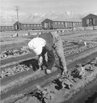 Figure 8.11. Victory gardens in a firebreak at Manzanar. (Dorothea Lange photograph, Bancroft Library, University of California, Berkeley) |
 Figure 8.12. Lath house with seedling guayule plants. (Dorothea Lange photograph, Bancroft Library, University of California, Berkeley) |
 Figure 8.14. 1944 aerial photograph showing relocation center farm fields north and south of the developed area at Manzanar, north to right. (Los Angeles Department of Water and Power) (click image for larger size (~132K) ) |
Initially sewage was treated in a 100-foot-by-20-foot-by-6-foot-deep septic tank. But, by the end of August 1942, a sewage treatment plant was completed 1-1/2 miles east of the relocation center. The 1.25 million gallon a day capacity sewage treatment plant included a control room, a clarifier, a digester, a chlorination tank, and four settling ponds. The settling ponds were apparently never used: LADWP was concerned that the ponds would provide a breeding place for ducks that would then contaminate the aqueduct. Instead the liquid sewage was chlorinated and allowed to flow via an open ditch into the Owens River.
A cemetery for the relocation center was located just outside the fenced central area on the western perimeter. A commemorative monument was built in the cemetery in August 1943. Over 135 people died at Manzanar during operation of the relocation center, but only 28 were buried in the cemetery. After the relocation center closed, all but six of the burials were moved to other cemeteries (Merritt 1946).
On November 21, Manzanar was the sixth relocation center to close. Salvage of the relocation center's buildings and materials was administered by the War Assets Administration. By December 1946, except for a few buildings in the administration and staff housing area, Manzanar was completely dismantled. The remaining buildings were used for a Veterans Housing Project. Records show 126 veterans and other people living there in August, 1948. But the veterans resided at Manzanar for only a couple of years and the building were removed. Inyo County purchased the relocation center auditorium after the center closed and leased it to the Independence Veterans of Foreign Wars who used it as a meeting hall and community theater until 1951. It was then used by the Inyo County Road Department until purchased by the National Park Service in 1996.
Manzanar was the site of one of the most serious civil disturbances to occur at the relocation centers, the "Manzanar Riot" or "Manzanar Revolt." The revolt erupted in December 1942 following months of tension and gang activity between Japanese American Citizens League (JACL) supporters of the administration and a large group of Issei and Kibei. Many of the evacuees did not regard the young JACL leaders, whom the administration relied upon, as representatives. Aliens were excluded from positions of importance in the relocation center administration, and from the better-paying jobs. Public meetings turned into shouting sessions; there were beatings, and death threats against the pro-administration Nisei were common. Recycling and garbage collection trucks with Kibei crews flying Black Dragon flags tried to stop work at the camouflage net factory, threatened workers, and even attempted to run people over. An incendiary blaze was set in late November at the co-op store, which was seen as a symbol of JACL collusion.
On December 6 a JACL leader was beaten by six masked men. Harry Ueno, the leader of the Kitchen Workers Union, was arrested for the beating and removed from the center. Soon afterward, 3,000 to 4,000 evacuees held a meeting, marched to the administration area, and selected a committee of five to negotiate with the administration. In exchange for a promise of no more demonstrations, the center director agreed to bring Ueno back to the relocation center jail.
However, when Ueno was returned the crowd formed again. Fearing the worst, the director called in the military police. The crowd sang patriotic Japanese songs, taunted the soldiers, and even threw rocks at the military police, who then used tear gas to break up the crowd. When a truck was pushed toward the jail, the military police fired into the crowd. A 17-year-old boy was killed instantly. A 21-year-old man, shot through the stomach, died in the hospital several days later. Nine other evacuees were wounded, one evacuee was treated for exposure to tear gas, and a military police corporal was wounded by a ricocheting bullet.
The committee of five was immediately arrested. Mess hall bells rang as the military police, augmented by local National Guard volunteers, patrolled the streets inside the relocation center trying to restore order. Several times during the night tear gas was used to break up crowds and impromptu meetings at mess halls. Gangs armed with knives and other weapons searched for individuals on a well-publicized death list. Sixty-five people, including the JACL leader who had been beaten, were housed in the military police compound for their own protection. Three days later they were transferred to a former CCC camp in Death Valley where they would live for the next 2-1/2 months.
In the following days 15 "troublemakers" were removed from the relocation center and held in local jails. In January they were sent to Department of Justice camps if they were aliens or to a WRA isolation center at Moab if they were citizens. The breadth of the revolt at Manzanar is evident in that only two of the 16 arrested and removed from the relocation center were from the same residential block (Ueno and another were from Block 22). And, there was widespread support for the "troublemakers": most work in the relocation center stopped for several weeks. Oil delivery and kitchen crews kept working, but all other work was suspended by the administration until after Christmas, since evacuees refused to show up. The camouflage net factory never reopened.
Central Fenced Area
All of the relocation center features at Manzanar have been recorded in detail, as part of studies undertaken for the General Management Plan for the National Historic Site (Burton 1996). The following descriptions are condensed from that report. Only three of the over 800 buildings originally at the relocation center remain. However, there is abundant evidence of relocation center features, including walls, foundations, sidewalks, steps, manholes, sewer and water lines, landscaping features, ditches, and trash concentrations. Much of the relocation center road grid remains, but many of the roads in the western third are buried by alluvium or overgrown with vegetation (Figure 8.16). Other roads are cut by gullies and major portions of two roads (1st and 7th Streets) have been destroyed by gully erosion. By far the most prevalent artifact types at the site are window and bottle glass fragments and wire nails. However, a tremendous variety of artifacts dating to the relocation center use are scattered across the central area.
 Figure 8.16. 1993 oblique aerial view of the central area of the Manzanar Relocation Center. |
Central Fenced Area
Entrance and Administrative Areas
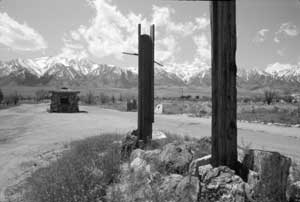 Figure 8.17. Entrance to the Manzanar Relocation Center today. |
Two paved roads run east-west from U.S. Highway 395 into the relocation center. Between these roads are two evacuee-constructed buildings, a sentry post and a police post, and a low rock-encircled earthen mound with wooden posts remaining from the relocation center entrance sign (Figure 8.17). There are rock alignments along the outside edges of the roads and rock-outlined parking spaces along the north road between the sentry post and the police post.
The sentry post is a 13-foot-by-14-foot one-room rock and concrete building (Figure 8.18). Across the road north and south of the sentry post along the perimeter there are short sections of rock and concrete walls. Decorative concrete tree stumps that were on both sides of the sentry post have been removed, and are now located at a house in the town of Independence. Located west of the sentry post, the police post is an 8-foot-by-10-foot one-room rock and concrete building (Figure 8.19). The sentry post and police post both have pagoda-style wood shake roofs and simulated wood concrete lintels over the doors and windows. North of the police post is the 20-foot-by-100-foot concrete slab of the police station (Figure 8.20).
Southwest of the entrance the administration office building location is outlined by an L-shaped rock alignment. Within the rock alignment there are four concrete footing blocks and a small concrete foundation that apparently once held a safe. On the building exterior on the north side there are two circular planters and a sidewalk incorporating a diamond-shaped planter with a metal flagpole base (Figure 8.21).
Southwest of the administration building there is a 30-foot-diameter rock and concrete planter within a traffic circle (Figure 8.22). It has many inscriptions listing Japanese American names, hometowns, and dates (Figure 8.23). A 40-inch-by-60-inch concrete slab located west of the traffic circle is divided into six panels; two are inscribed with the name "Kubota" and one has a "4/1/42" date (Figure 8.24). Remains at the staff mess hall consist of concrete footing blocks and a concrete slab with a few inscribed Japanese characters. The only remains at the town hall building and the post office are landscaping features: both have rock alignments at their north end and the town hall building has a concrete sidewalk.
The most prominent feature remaining in the staff housing area is a concrete slab patio and 3-foot to 6-foot-high wall of granite boulders and concrete at the director's residence (Figure 8.25). Also at the director's residence there are three concrete entryways, a small slab for a water heater, some concrete footing blocks, and a rock-outlined asphalt parking area. Remains of the staff apartment and dormitory buildings include concrete walkways and steps (Figure 8.26), small concrete slabs for water heaters (Figure 8.27), and a few concrete footing blocks. At one building location there is a concrete and rock pedestal, 30 inches high with a simulated wood grain top, that may have once held a sign (Figure 8.28). At another building location there is a 2-1/2-feet-to-5-feet high concrete and rock wall enclosing a concrete slab patio (Figure 8.29). Remains of the evacuee-built laundry room in the staff housing area consist of a 16-foot-by-20-foot concrete slab with a central floor drain.
Other remains in the administration and staff housing areas include a concrete slab and brick-lined hole (possibly a pit barbecue), a clothesline pole base, rock alignments bordering roads, parking areas, and buildings, remnants of asphalt roads and parking areas and gravel walkways, intact manholes, concrete and rock ditches, and storm drains. Remains of a staff victory garden are located between the staff housing area and the perimeter fence.
West of the administration and staff housing area are the foundations of the service station and gasoline pump (Figure 8.30). Nearby, the motor pool office location is indicated by concrete stoops on the north and west sides of an apparent 20-foot-by-50-foot building pad and a surrounding rock alignment. An inscription and a hand and a foot print are on the west entry slab. A pipe flush to the ground centered between two tall poles is likely the remains of an entrance gate to the motor pool parking area.
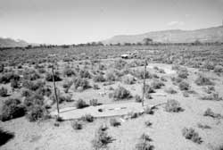 Figure 8.30. Concrete island from gasoline pump. |
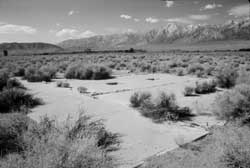 Figure 8.31. Concrete slab foundation of automotive services garage. |
Remains in the garage block include the automotive repair shop foundation and the automotive service garage foundation (Figure 8.31). Two parallel 20-foot-by-100-foot foundations are from the refrigerated warehouse. Both are perimeter foundations into which a concrete slab was later poured. The refrigeration equipment was apparently at the north end of each slab, where there is a waste pipe, two other pipes, a floor drain, and a remnant dividing wall. In the south-central portion of the block there is a 6-foot-by-10-foot concrete slab with the center portion broken out. Its central location suggests it may have been a latrine. Other features include three concentrations of rocks and boulders, two manholes, and a few concrete footing blocks at the locations of two other buildings.
Remains in the two warehouse blocks include a 20-foot-by-100-foot concrete floor of five contiguous 20-foot-by-20-foot slabs. There is a mostly buried concrete driveway on the south end. One or more concrete footing blocks remain at nineteen of the other warehouses. Two latrine concrete slabs, ne in each warehouse block, are 16 feet by 27 feet, divided into two rooms. Other features noted in the warehouse blocks include three asphalt driveways, some indistinct rock alignments, and two manholes. Southwest of the warehouses, where there were additional garages, there are three 20-foot-by-100-foot structure pads, each indicated by a leveled area with concrete footing blocks along one side, and one mostly buried 20-foot-by-100-foot concrete slab.
 Figure 8.18. Military police sentry post at the Manzanar Relocation Center today. |
 Figure 8.19. Internal police post at the Manzanar Relocation Center today. |
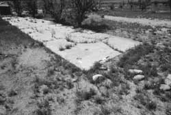 Figure 8.20. Concrete slab foundation of the Manzanar police station. |
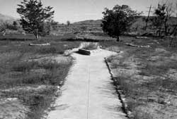 Figure 8.21. Sidewalk at the location of the Manzanar administration building. |
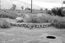 Figure 8.22. Traffic circle in the administration area at Manzanar. |
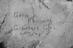 Figure 8.23. Inscription in the concrete top of the traffic circle. |
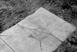 Figure 8.24. Small concrete slab in the administration area at Manzanar. |
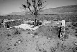 Figure 8.25. Patio and walls at the Manazanar Relocation Center director's residence. |
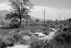 Figure 8.26. Concrete steps to building in the administration and staff area. |
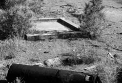 Figure 8.27. Concrete slab for water heater at a staff apartment. |
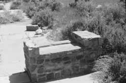 Figure 8.28. Rock and concrete pedestal for a sign in the administration and staff area. |
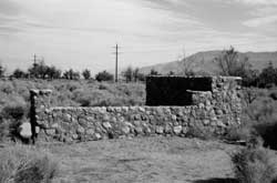 Figure 8.29. Rock and concrete wall at staff apartment. |
Central Fenced Area
Factory Area
At the camouflage net factory location there are four parallel concrete slab foundations. Three measure 24 feet by 300 feet (Figure 8.32). One has numerous rust stains from steel drums on its north end. Another has an attached concrete slab 2 foot by 3 foot with an incomplete inscription reading: "mar. 30th 194..." The westernmost net factory foundation is a 24-foot-by-100-foot concrete slab. Southwest of the net factory foundations there are two small U-shaped concrete foundations, possibly tank supports, and a pile of hotel ware ceramic fragments. Southeast of the net factory, just outside the perimeter security fence, there is a roughly 1 acre area that includes hundreds of barrel hoops (Figure 8.33), several large piles of brown and clear glass jug fragments, and other trash that may be related to the factory operation or demolition.
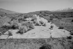 Figure 8.32. Concrete slab foundation of building at the camouflage net factory. |
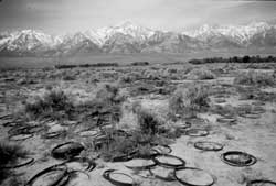 Figure 8.33. Barrel hoopos near the camouflage net factory. |
To the west of the net factory foundations was the garment factory location, now indicated by a dirt mound and remnants of a concrete border, possibly from a perimeter foundation. Remains of the root storage building consist of a dirt mound, a small depression, and some sinkholes, possibly indicating an infilled trench or pit. East of the net factory foundations, the mattress factory location is indicated by rock and concrete alignments at its north end. A dirt road now runs the length of the building site.
Central Fenced Area
Hospital
In the main hospital area, some concrete footing blocks remain at the administration building, doctors' quarters, nurses' quarters, mess hall, wards, and storerooms. Across the road in the firebreak south of the hospital, at the location of the evacuee-built Caucasian hospital staff quarters, there is an 18-foot-by-4-foot sidewalk and entry, a 7-foot-square concrete slab entry, and a 5-foot-by-8-foot concrete slab entry.
Other buildings at the hospital had concrete slab foundations, still visible at the hospital laundry, heating plant, and morgue (Figures 8.34-8.36). A 90-foot-long sidewalk attached to the morgue leads toward the hospital laundry room. It has six inscriptions, including one in Japanese. North of the morgue, the garbage can washing rack foundation consists of a 20-foot-by-35-foot concrete slab with two concrete rings to support garbage cans, a drainage trough, and a large grease trap (Figure 8.37). Other features in the hospital area include three intact manholes, a destroyed manhole, and a pulled manhole that was once embellished to look like a tree stump (Figure 8.38). Within the perimeter of the central portion of the relocation center, just west of the morgue, is a 3-acre area that includes a landfill used by the hospital, and other dumps and scattered trash from later use of the relocation center (ca. 1946-1949). The landfill has been recently capped by the National Park Service to discourage digging by relic collectors.
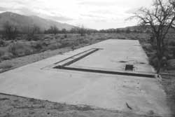 Figure 8.34. Concrete slab foundation of the hospital laundry. |
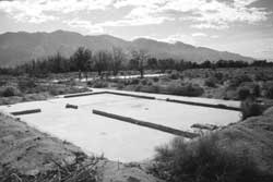 Figure 8.36. Foundation of the morgue. |
The most significant remains at the hospital are landscaping features built by the evacuees. These include rock and concrete retaining walls, an elaborate garden complex, rock alignments along the road east of the hospital, rock circles around trees, and a rock circle and a few rock clusters in the administration building area. A 3-foot-high rock and concrete retaining wall located between the administration building and the hospital wards incorporates a concrete bench with a simulated wood finish and curving rock and concrete steps to each of the wards (Figures 8.39 and 8.40). The retaining wall is partially buried and has been cut in two areas by gullies and two stairways have been destroyed. The laundry slab is enclosed on three sides by a 1-1/2-foot-high rock and concrete retaining wall; there is a cobblestone entryway with steps centered on the east side and a concrete entry ramp on the south end (Figure 8.41). The garden complex, located on the east side of the doctors' quarters location, includes a large concrete-lined pond and other landscape features (Figures 8.42 and 8.43; Table 8.1).
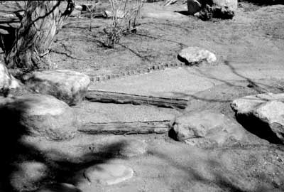
Figure 8.43. Stepping stones, wood steps, and concrete
path
at the hospital pond and garden complex.
Table 8.1. Representative ponds and gardens at Manzanar.
| Block | Description |
| Hospital | An elaborate garden complex, located on the east side of the doctors' quarters, includes a large concrete-lined pond, a stream, dispersed boulders for seating, two winding concrete walkways, boulder stepping stones, wood-reinforced pathway steps, rock borders, and other landscape features. |
| 2 | A small concrete-lined pond at the southeast corner of Barracks 2. |
| 6 | A rock garden, with some live and dead bamboo, covered with debris and leaf litter located between Barracks 14 and the mess hall. |
| 9 | An elaborate garden complex located between Barracks 14 and the mess hall, includes a large landscaped mound, boulders, a stream, rock alignments, and a buried pond. A concrete stoop for the mess hall has a simulated wood pattern and color. Another concrete stoop, on the east side of Barracks 2, has the same pattern and color. |
| 10 | An elaborate garden complex located between Barracks 12 and 13 with a concrete-lined pond, earthen mound, bench, and rock alignments. |
| 12 | An elaborate garden complex located between Barracks 14 and the mess hall, has a large concrete-lined pond, a stream with waterfalls, an island, a sidewalk, and rock alignments. |
| 15 | A small garden at the south and southeast end of Barracks 8, with concrete sidewalks, a concrete stoop, rock alignments, and a 3-foot-high upright automobile driveline used as a decorative element. |
| 22 | An elaborate garden complex located between Barracks 14 and the mess hall, includes a concrete-lined pond, a concrete sidewalk, a bridge, a waterfall, an island, and rock alignments. Inscribed in the concrete top of the bridge is "AUG. 9, 42" and in the north end of the pond the date "8-7 1942" is formed with small stones imbedded in concrete. |
| 24 | A small concrete-lined pond located between Barracks 5 and 6, with a concrete and rock channel leading away from it at the southwest corner of the mess hall. |
| 24 | A small concrete-lined pond, concrete slabs, a walkway, and rock alignments located between Barracks 8 and 9. |
| 34 | An elaborate garden complex located between Barracks 14 and the mess hall, includes a rocky mound, a concrete- lined pond, a stream, a bridge, rock alignments, and a collapsed barbed wire fence. The rocks used in the garden are metavolcanic, rather than the more commonly used local granite boulders and cobbles. |
| 35 | Rock alignments, cobblestone and concrete stoops, two 3-foot high circular planters, and a small concrete bridge along the west and north sides of Barracks 8. |
| 36 | A concrete-lined pond, a possible rock and concrete fountain, and a rock-lined concrete bridge with the inscription "36-12" located at the north end of Barracks 12. |
| 36 | A small garden with a cholla, a beavertail, and a barrel cactus located northeast of Barracks 14. |
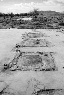 Figure 8.35. Foundation of the hospital heating plant. |
 Figure 8.40. Steps at hospital ward. |
 Figure 8.37. Foundation of the garbage can washing rack. |
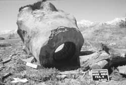 Figure 8.38. Pulled manhole at hospital. |
 Figure 8.39. Concrete bench incorporated into retaining wall at the hospital. |
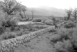 Figure 8.41. Rock and concrete retaining wall at the hospital laundry. |
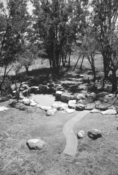 Figure 8.42. Remains of pond and garden complex at the Mananar hospital. | |
Central Fenced Area
Evacuee Residential Area
 Figure 8.44. Barracks footing blocks at Manzanar. |
Within the evacuee area little evidence remains of the barracks themselves. Concrete footing blocks are at some of the barracks locations (Figure 8.44), as are some of the pipes of the water faucets that were on the exterior of every other barracks. Concrete or rock overflow basins are present at many of the water faucets, including one in Block 19 inscribed with "June 6, 1943" and one in Block 11 inscribed with "1944" (Figures 8.45 and 8.46). At some of the barracks locations there are shallow depressions likely from infilled basements.
Nearly all of the concrete slab foundations for the latrines, laundry rooms, and ironing rooms are intact. However, some are buried by sheet wash, and in Block 1 all of the slabs have been broken up and piled and in Block 7 they have been removed. The laundry room slabs measure 20 feet by 50 feet. The ironing room slabs are 20 feet by 28 feet. The latrines consisted of two separate (men's and women's) 20-foot-by-30-foot buildings. The women's has holes for 10 toilet fixtures, the men's has eight, each had a single shower stall and a single hot water heater (Figure 8.47).
Manholes remain in many of the blocks (Figure 8.48), but water and sewer lines appear to have been removed from some blocks. Only two fire hydrants remain, both are near the auditorium. One is surrounded by a circle of rocks (Figure 8.49). Lettering on the hydrants indicate they were made by Pacific States of Provo, Utah.
Evidence of hundreds of evacuee landscaping improvements are still present, and together they comprise some of the most significant features at the relocation center site. These include concrete, rock, cobblestone, and asphalt sidewalks, walkways, and entries. Some entries were decorated, such as a concrete stoop with imbedded glazed pipe fragments at Barracks 8, Block 3, a simulated-wood concrete stoop at Barracks 2, Block 9, and an incised and painted concrete stoop on the south side of Barracks 13, Block 22 (Figures 8.50 and 8.51). Some include addresses, "9=6=1" (Block 9) and "15-13-4" (Block 15), names, or dates, "Shintoni May 21, 1944" (Block 11) and "May 8, 1942" (Block 34) (Figure 8.52). A small concrete slab on the south side of Barracks 11, Block 18, has two deliberate handprints (Figure 8.53). Photographs at the Eastern California Museum indicate that more inscriptions were once within the central area.
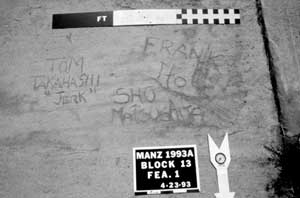 Figure 8.64. Incriptions at the Manzanar fire station. |
Other landscaping features and improvements include rock alignments along roads, around trees, and at barracks entries (Figure 8.54), a rock and concrete fountain, a concrete-lined wading pool (Figure 8.55), an arbor (Figure 8.56), clothesline posts (Figure 8.57), low fences and walls, and wooden borders and edging. The most elaborate evacuee improvements were gardens, many with ponds, waterfalls, walkways, and bridges (Figures 8.58-8.62; Table 8.1).
There are still slabs from the relocation center fire department in the east-central portion of Block 13 with various levels and types of concrete indicating more than one building episode (Figure 8.63). The entry ramp has a few shoe imprints and several inscriptions (Figure 8.64). There are two storm drains constructed of concrete and rock along the road east of Barracks 1, Block 1. A 40-foot-by-100-foot concrete slab (possibly a patio) covers the entire area between Barracks 13 and 14 in Block 13.
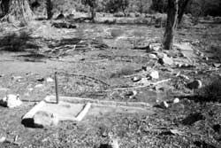 Figure 8.45. Exterior faucet in the evacuee barracks area at Manzanar. |
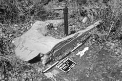 Figure 8.46. Exterior faucet in the evacuee barracks area at Manzanar. |
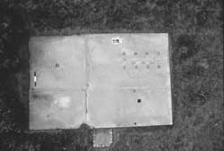 Figure 8.47. Overhead view of a concrete slab foundation of a men's latrine. |
 Figure 8.48. Manhole and cover. |
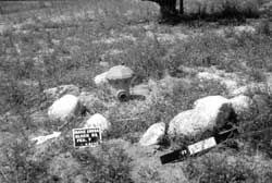 Figure 8.49. Fire hydrant. |
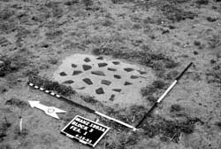 Figure 8.50. Concrete stoop with embedded pipe fragments. |
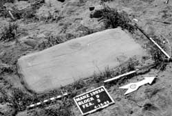 Figure 8.51. Simulated wood concrete stoop. |
 Figure 8.52. Concrete stoop with address formed by embedded stones. |
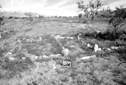 Figure 8.54. Rock alignments at barracks entry. |
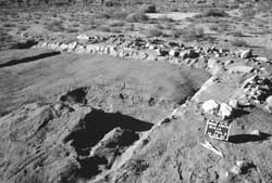 Figure 8.55. Partially exposed concrete-lined wading pool. |
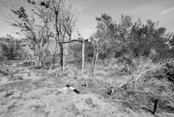 Figure 8.56. Wood arbor. |
 Figure 8.57. Wood clothesline pole. |
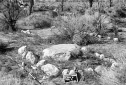 Figure 8.58. Rock work at Block 9 pond and garden complex. |
 Figure 8.59. Block 22 pond and garden complex. |
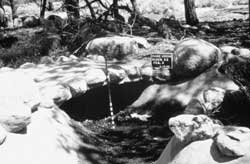 Figure 8.60. Concrete bridge at Block 22 pond and garden complex. |
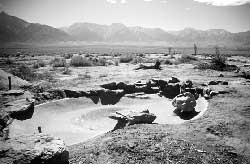 Figure 8.61. Block 34 pond. |
 Figure 8.62. Block 12 pond and garden complex. |
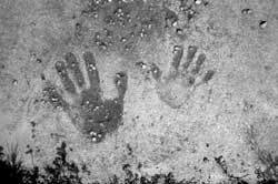 Figure 8.53. Handprints in concrete. |
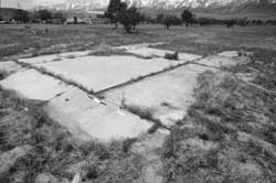 Figure 8.63. Concrete slab foundation of the Manzanar fire station. |
Central Fenced Area
Other Areas and Features
The auditorium, constructed by the evacuees, is a 12,500-square-foot wood frame building with horizontal siding on the north, west, and south sides and vertical siding on the west side (Figure 8.65). It consists of a central 82-foot-by-125-foot structure (auditorium) with a low-pitched gambrel roof, with a two-story extension on the west side (entry and projection booth) and a one-story wing along the north side (dressing and rest rooms). A similar wing along the south side of the building was removed prior to the early 1950s; the "cornerstones" from this wing were dumped in Block 13 (Figure 8.66). The building has been further modified for use as a vehicle maintenance facility by the Inyo County Road Department. The auditorium wood floor was replaced by a concrete slab and the stage at the east end of the auditorium was removed and replaced by a large truck door.
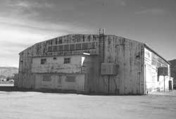 Figure 8.65. Manzanar auditorium in 1994. |
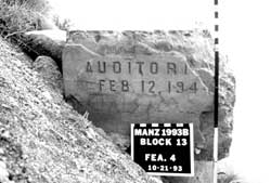 Figure 8.66. Auditorium cornerstone. |
South of the auditorium was Block 7, used as the relocation center high school, but because the northern one-third of the block was within the fenced Inyo County Maintenance Yard, it has been very disturbed. The concrete slabs for the men's latrine, the women's latrine, the laundry room, and the ironing room have been removed; all that remains of them is a small pile of concrete rubble. Barracks remains consist of two concrete footing blocks, eight upright water faucet pipes, and a few evacuee-constructed rock alignments. Recently a septic system for the auditorium was put in Block 7 by the National Park Service.
Little remains at the elementary school, which made use of the buildings in Block 16, other than the concrete slabs of the toilets, laundry, and ironing room, some rock alignments, and a few other disturbed landscaping features.
At the Children's Village, the three building locations are marked by some of the original foundation blocks. Gully erosion has destroyed the original road to the north of the Children's Village; a replacement dirt road now crosses the building locations.
Remains of sports and recreation facilities can be found within the evacuee residential area. A basketball post is at Block 3. There are decorative rock alignments, concrete slabs, concrete stoops, and elaborate rock-lined cobble and concrete walkways at the location of the evacuee-built judo house south of Block 16 (Figure 8.67). Remains of baseball and softball fields in the firebreak between Blocks 19 and 25 include lumber fragments and downed chicken wire, mostly buried by drifting sand, where the backstops used to be, and a low earthen mound at the baseball field's pitcher's mound. There is a wood home plate in the firebreak between Blocks 30 and 35 (Figure 8.68).
The firebreak west of the auditorium includes evidence of three tennis courts. There is a simple rock alignment remaining at one, remnants of concrete and rock net supports and an area of discolored soil (possibly from a clay court) at another, and a partial concrete border at the third one. The concrete border, roughly the size of a standard tennis court, has been badly damaged by a recent ditch.
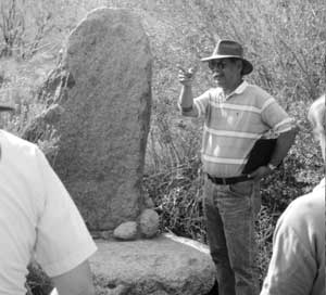 Figure 8.69. Rock work at Merritt (Pleasure) Park. |
The eastern one-third (firebreak) of Block 34 was used as a lavishly landscaped park, variously named Rose, Pleasure, and Merritt. This area has been heavily disturbed with most landscaping elements destroyed. At both the southwest and southeast corners of the park at the road there is a large elongated boulder cemented upright on a low flat boulder (Figure 8.69). Scattered rocks at both locations are probably the remains of associated rock alignments. Remains at a former teahouse location in the southwest portion of the park consist of a raised rectangular area enclosed by a rock border (Figure 8.70). To the north there are scattered rocks and a large depression. Further to the north there is another smaller depression and a small area of concrete and rock work. Apparently mostly buried, the feature may have been a concrete-lined pond or possibly the remains of a Dutch oven shown in this area on WRA blueprints. Between this feature and the teahouse location there are the disturbed remains of a large rock garden and a possible fountain.
Two large barbecue grills (Figure 8.71), constructed of concrete and stone, are in the central portion of the northern perimeter in an area used by the evacuees as a park (North Park). One is inscribed with "Ray Kobote, August 1943." Another grill, of much less substantial construction, is located in the perimeter southwest of Block 4. It consists of a crude, low U-shaped grill-like feature made of cement and concrete blocks.
In the southwest corner of the central area, west of the lath house location, there are several depressions, concrete rubble, and a portion of concrete wall at the location of the first relocation center outdoor theater. No remains associated with the nearby golf course and developed picnic area on Bairs Creek were located. Two concentrations of concrete steps and other rubble along the edge of Bairs Creek appear to be from dismantled buildings in the administration area.
There are still remnants of the evacuee and staff victory gardens in the firebreaks and around the perimeter of the residential area. Sections of pipe and ditches (both earthen and concrete-lined), some including lumber, fencing, and culverts, remain from the irrigation systems (Figure 8.72). The irrigation system that diverted water from Bairs Creek to the staff victory garden is largely intact, though no longer in use. It includes a dam, a concrete pipeline, earthen ditches, and a settling basin. Inscribed within the concrete cap wall of the dam is the date "1942." Along the ditch there are a low U-shaped concrete water diversion structures, one has several inscriptions, including names, initials, four 1943 dates (Figure 8.73), and a fallacious 1940 date.
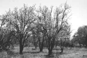 Figure 8.74. Pear trees near the Manzanar Childern's Village. |
Many of the fruit trees planted by the earlier town residents and cared for by the evacuees still remain. The best examples are east of the Children's Village and northeast of Merritt Park (Figure 8.74).
There are no remains apparent at the guayule lath house that was southwest of Block 6. But nearby there are several features likely associated with the lath house, including a large rectangular area enclosed by tamarisk and a barbed wire fence, two shallow rectangular depressions possibly from gardens, and an 11-foot-square concrete slab with the inscription "12.30.42." Nearby are concentrations of sanitary seal cans with punched bottoms which were probably used for seedlings.
Other features in the perimeter of the central area include a capped well, a fuel oil storage tank area, and numerous small artifact concentrations. Most of the latter were probably deposited as the relocation center was abandoned. Also present are three building foundations; although two are depicted on the WRA blueprints, their functions are unknown. One has the inscription "1944." They may have served as storage for the victory gardens or outlying farms.
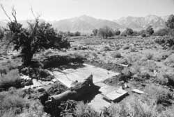 Figure 8.67. Remains of the Manzanar judo house. |
 Figure 8.68. Baseball home plate in firebreak at Manzanar. |
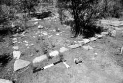 Figure 8.70. Teahouse location at Merritt (Pleasure) Park. |
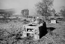 Figure 8.71. Barbeque grills at Manzanar North Park. |
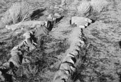 Figure 8.72. Concrete and rock irrigation ditch for victory gardens. |
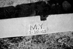 Figure 8.73. Inscription in a diversion box of the staff victory garden irrigation system. |
Security Features
As discussed above the sentry post and police post both remain at the relocation center entrance, as does the foundation of the police station, where the shootings of the "Manzanar Riot" occurred.
Remains of seven of the eight watch towers around the fenced perimeter are present. Nothing remains of the tower in the northeast corner of the relocation center; the location is now within a graded road. Although two other towers were located within the same road, pulled footings were found near their original locations. The pulled footings varied from 3 feet to 4 feet in total length, and a maximum of 2 feet in diameter. At the five remaining watch tower locations, foundations visible above ground consist of four 1-1/2-foot-by-1-1/2-foot concrete footing blocks with steel straps, spaced 11 feet apart (Figure 8.75).
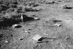 Figure 8.75. Watch tower foundation blocks. |
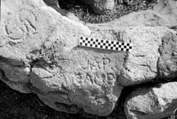 Figure 8.76. Inscription near the southwest watch tower. |
Near the watch tower footing blocks in the southwest corner of the central area there is a rock and concrete penstock inscribed with a first name, initials, a date, and the epithet "jap camp" (Figure 8.76). In addition, "Summers 1942" is formed by pebbles that were pressed into the wet concrete of the penstock. Charlie Summers was the local contractor that built the relocation center watch towers. Not much remains at the three gate house locations, once located at roads to the outlying farm fields and the relocation center landfill. At the gate house on the north perimeter there is a small rock concentration, and at the gate house on the west perimeter, there are some rocks and asphalt. There are no apparent remains of the gate house on the south side of the relocation center.
Portions of the existing barbed wire fences on the west, north, and possibly east sides of the central area appear to be from the relocation center (Figure 8.77). These fence sections are constructed of either 4-inch by 4-inch or 4-inch by 6-inch wooden posts (both nominal and actual), placed approximately 16 feet apart. These posts are distinguished from those in typical range fences in the area by their material, height (extending over 5 feet high), and patterns of nail holes. Nail holes indicate these posts originally held five wire strands at about 12-inch intervals starting at 12 inches above the ground. The top and bottom strands have been removed.
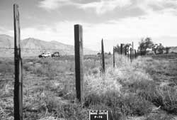 Figure 8.77. Original section of the perimeter security fence along U.S. Highway 395. |
 Figure 8.78. Concrete slab founation in the Manzanar military police compound. |
At the military police compound the locations of all 13 known buildings, except the evacuee-constructed entry post, can be discerned. Barracks locations are defined by level areas, some with a few concrete footing blocks. The officer's quarters location has a rock-lined walkway and a small yard. The guard house (military personnel jail), latrine, and first aid buildings are evident by concentrations of wire nails, concrete chunks, and other structural debris. Most of the sizable rocks at the site have traces of white paint on them. At the location of the military police motor repair shop there is a terraced area with six large concrete foundation blocks with embedded iron bars. Artifacts in the vicinity include a small electric motor core, over 25 metal bushings, and an electrical porcelain knob. A 20-foot-by-25-foot concrete slab east of the motor repair shop location is inscribed with three sets of initials (Figure 8.78). No building is shown on WRA blueprints at this location, however the slab is visible on a 1944 aerial photograph. Another enigmatic feature, located south of the barracks area, is a 1-foot-wide concrete perimeter foundation, outlining an area 7-1/2 feet by 9-1/2 feet in size.
Outlying Area
There are features remaining from virtually all of the relocation center developments outside the central fenced area. This includes the cemetery, farm fields and ditches, the chicken and hog farms, the water supply system, the sewage disposal system, and other features.
Cemetery
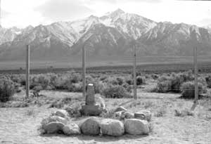 Figure 8.80. Grave at the Manzanar Relocation Center cemetery. |
The relocation cemetery is located on the west side of the central fenced portion of the relocation center. At the cemetery there is a large concrete obelisk with Japanese inscriptions on two sides (Figure 8.79). The inscription on the front (east) side translates as "Monument to console the souls of the dead" and the inscription on the back (west) side translates as "Erected by the Manzanar Japanese August 1943." Around the monument there is a concrete slab and nine concrete posts shaped and stained to resemble wood. Within the fenced cemetery area there are 14 rock-outlined plots (Figures 8.80 and 8.81), two with cut stone markers with inscriptions, two with wood posts, and one with a small unreadable wooden sign. Also within the fenced cemetery area there are three concrete foundations for wooden fence posts, one with an inscription. Across a dirt road north of the fenced cemetery enclosure there are three rock-outlined pet graves (Figure 8.82).
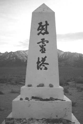 Figure 8.79. Monument at the Manzanar Relocation Center cemetery. | |
 Figure 8.81. Grave at the Manzanar Relocation Center cemetery. |
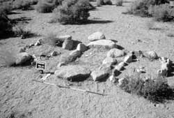 Figure 8.82. Pet cemetery at Manzanar. |
Outlying Area
Farm Fields and Irrigation Ditches
The only relocation center farm fields currently in use are the northernmost fields along the west side of U.S. Highway 395. All of the other fields and ditches of the relocation center farms lie abandoned.
Outside of the cultivated fields the ditches that brought irrigation water to the north fields are in good condition and easy to follow (Figure 8.83). There are numerous inscriptions in the concrete of the ditches, including names, initials, dates, Japanese characters, expressions of love, and a geometric design (Figure 8.84). A dam on Shepherd Creek, measuring approximately 46 feet across, was built for the early twentieth century town of Manzanar. Evacuees raised the height of the dam by adding 18 inches of concrete wall, and inscribed two sets of initials on top.
 Figure 8.83. Concrete-lined irrigation ditch near Shepard Creek. |
 Figure 8.84. Inscription in the Manzanar North Fields irrigation ditch. |
North and northeast of the northernmost farm fields there are two wells located on opposite sides of U.S. Highway 395, that were connected by a 2,750-foot-long concrete pipeline, now partially destroyed. An upturned concrete support near one of the wells is inscribed with "finished by tom fujisaki & crew mar. 23, 1944" (Figure 8.85). Parts of two bridges over Shepherd Creek built by the evacuees to access the north fields are still in use.
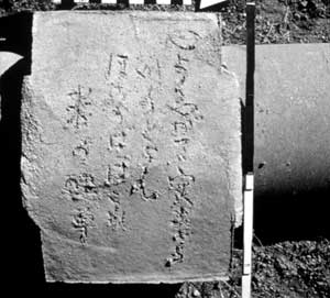 Figure 8.89. Japanese poem inscribed on pipeline support. |
Just south of the central area there are many remnants of the irrigation system that watered the southern farm fields, including concrete-lined and dirt ditches, concrete diversion boxes with wooden gates, a concrete pipeline, a 45-foot-long dam across George Creek, wells, and other features (Figures 8.86-8.88). The pipeline alignment appears as a raised berm for most of its length. Concrete piers were used to support the pipeline where it crossed washes and low spots. The top of two of these supports, on the south side of a small wash, each have a Japanese poem inscribed on them (Figure 8.89). The concrete ditches and diversion boxes include inscribed names, initials, dates, military slogans, and the greatest concentration of Japanese language inscriptions at the relocation center (Figure 8.90 and 8.91).
At George Creek, 1 mile south of the central area just west of U.S. Highway 395, there is a dam, a bridge, two wells, concrete-lined ditches and concrete pipelines, and various water control features (Figure 8.92). Inscriptions in the irrigation ditches include dates and Japanese characters translated as family names. There is an upright boulder with two smaller cemented rocks as decorative elements at each corner of the 10-foot-by-16-foot bridge (Figure 8.93). Six inscriptions in the concrete of the retaining walls at the bridge and a nearby pipe support include names, dates, Japanese characters translated as "Built by E Group in March 1944," and two place names, both "tucson," one is dated "3/6/44."
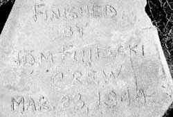 Figure 8.85. Inscription at well north of the Manzanar North Fields. |
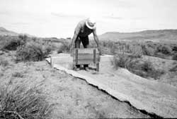 Figure 8.86. Wood control gate on one of the South Fields irrigation ditches. |
 Figure 8.87. Irrigation ditch for the Manzanar South Fields. |
 Figure 8.88. Irrigation ditch for the Manzanar South Fields. |
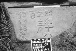 Figure 8.90. Inscription on South Fields irrigation ditch. |
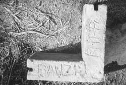 Figure 8.91. Inscription on South Fields irrigation ditch. |
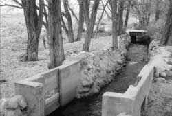 Figure 8.92. Dam and retaining walls on George Creek. |
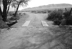 Figure 8.93. Bridge over George Creek. |
Outlying Area
Chicken and Hog Farms
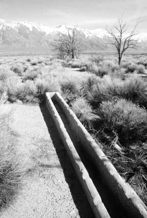 Figure 8.98. Manzanar hog farm today. |
The relocation center chicken farm was located just outside the southwest corner of the fenced central portion of the relocation center. Remains include numerous concrete slab foundations of the office and processing plant and coops, rock and concrete retaining walls, rock alignments, and an ornate 6-foot-high incinerator made of rock and concrete (Figures 8.94-8.96). Rows of black locust trees enclose the site, and within the site there are many more black locust trees and one Arizona cypress. Sheet wash has buried portions of some slabs and some features are overgrown by brush and weeds. Inscriptions in the concrete include mostly names and Japanese characters (Figure 8.97). Artifacts at the chicken farm include window glass fragments, bottle glass fragments, hotel ware ceramic fragments, wire nails, cans, pieces of lumber, bricks, clay sewer pipe fragments, and electrical porcelain knobs.
The relocation center hog farm, located-1/2 mile south of the residential area, includes several concrete slabs, some with feed troughs (Figure 8.98), a rectangular pen area defined by alignments of black locust trees, other related structures and features, scattered artifacts, and a 1,150-foot-long access road and pipeline. A concrete weir box and section of concrete-lined ditch where water was diverted from a dirt ditch has a partial 1940s date and a group of damaged Japanese inscriptions translated as seven family names and "Group B."
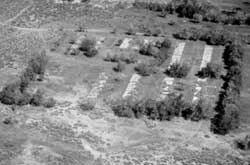 Figure 8.94. Oblique aerial view of the Manzanar chicken farm today. |
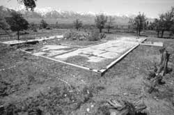 Figure 8.95. Foundation of the slaughterhouse/office at the Manzanar chicken farm. |
 Figure 8.96. Incinerator at the Manzanar chicken farm. |
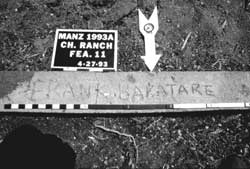 Figure 8.97. Inscription at the Manzanar chicken farm. |
Outlying Area
Water System and Reservoir
A dam on Shepherd Creek, 1-1/2 miles northwest of the central area, diverted water into an earthen ditch to the relocation center reservoir and settling basin, 1/2 mile northwest of the central area.
The concrete reservoir consists of a 120-foot-by-180-foot concrete-lined pool (Figure 8.99). To raise the water level a low stone and concrete wall was added by an evacuee work crew in February 1943. Several inscriptions were made in the wet concrete of the low cap wall. These include Japanese characters, names and dates, and the notation "stone wall by emergency crew 2/25/43" made of embedded pebbles. A large boulder along a dirt road on the west side of the reservoir was plastered with a thin layer of cement and inscribed while wet with the Japanese characters for "peace" (Figure 8.100).
A concrete-lined settling basin, approximately 75 foot by 80 foot, is located adjacent to the reservoir (Figure 8.101). On the east end there is a concrete wall with an opening to the reservoir and a spillway for bypassing the reservoir. Several areas along the wall have bottle caps pressed into the concrete and three groups of inscriptions were made while the concrete was wet. All Japanese characters, they have been translated as "the army of the emperor occupied territory, 2/17/43, to Manzanar," "banzai, the Great Japanese Empire, Manzanar Black Dragon Group headquarters," and "beat Great Britain and the USA" (Figures 8.102 and 8.103). During the relocation center occupation the inscriptions would have been under water most of the time.
A concrete- and rock-lined ditch directed water from a sand trap to the settling basin. Numerous inscriptions were made on top of the ditch wall and sand trap while the concrete was wet. Included are names, dates, Japanese characters, and the notation "constructed by chodo & inc. nov. 9 43" (Figures 8.104-8.106).
A concrete slab approximately 7 foot by 10 foot at the northwest corner of the reservoir was the foundation of a chlorination shed. A storeroom shown on WRA blueprints is indicated by wire nails, window glass, roofing, and scattered fragments of drywall and wood.
 Figure 8.107. Concrete slab foundation of the chlorination tank. |
Below the reservoir, nearly 3 miles of open concrete- and rock-lined ditches and buried concrete pipelines, several concrete weir boxes, the ten-sided 30-foot-diameter concrete slab foundation of the chlorination tank (Figure 8.107), and other water system features remain. All of the ditches are easy to follow, although many sections are damaged or silted in. The largest ditch segment, which originally held a steel pipeline, ran from the relocation center reservoir to the chlorination tank. All of the pipe has been removed.
Other ditches carried part of the water from the main pipe alignment to irrigate victory gardens within the central area of the relocation center. The ditches average 3 foot wide at the top and 1 foot wide at the bottom and are 1-1/2 feet deep. Segments of concrete pipe were used to span washes. On the west side of the chlorination tank foundation there is a concrete-lined ditch inscribed with names, dates, and Japanese characters.
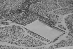 Figure 8.99. Oblique aerial view of the Manzanar water reservoir today. |
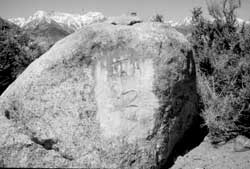 Figure 8.100. Boulder inscribed with Japanese characters for "peace". |
 Figure 8.102. Japanese inscription at the setting basin translated as "beat Great Britian and the USA". |
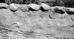 Figure 8.103. Japanese inscriptions at the setting basin translated as "banzai, the Great Japanese Empire, and Manzanar Black Dragon Group headquarters". |
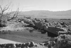 Figure 8.101. Setting basin at the Manzanar water reservoir. |
 Figure 8.104. Inscription at the sand trap. |
 Figure 8.105. Inscription at the sand trap. |
 Figure 8.106. Inscription at the sand trap. |
Outlying Area
Sewage Treatment Plant
 Figure 8.109. Clarifier at the Manzanar sewage treatment plant. |
The sewage treatment plant, located about 1 mile southeast of the relocation center residential area, was connected to the relocation center via a 4,600-foot-long sewerline. Manholes were spaced along the pipeline at 100 foot to 300 foot intervals, but many of the manholes have been destroyed.
Evidence of all of the sewage treatment plant structures remain (Figures 8.108 and 8.109). The control room remains consist of the 3-foot high raised concrete slab foundation of a three room structure measuring 30 feet east-west by 60 feet north-south. There are remnants of a decorative rock alignment on the north side of the foundation. North of the control room foundation, there is a series of concrete tanks of various proportions connected by 18-inch diameter concrete pipe which totals about 220 feet in length.
 Figure 8.108. Control room and digester at the Manzanar sewage treatment plant. |
The digester is an enclosed tank 42-1/2 feet in diameter and 19-1/2 feet high. The clarifier is a partially buried, round open-topped tank approximately 65 feet in diameter, with an interior depth of about 11 feet. One side of the tank is broken out, and all equipment has been removed. The chlorine tank is a rectangular concrete box measuring 36-1/2 feet by 16-1/2 feet, and extending 4 feet above the ground surface. Other remains at the sewage treatment plant include a concrete enclosure for a small pump, possible light fixture foundations, four rectangular settling ponds grouped together to form a larger 100-foot-by-200-foot rectangle, and an earthen ditch that carried treated sewage towards the Owens River.
Outlying Area
Landfill and Disposal Pits
The relocation center landfill covers 18 acres north of Bairs Creek about 1,000 feet west of the fenced central portion of the relocation center. The landfill consists of scattered trash and buried trash-filled trenches. There appears to have been at least five trenches, up to 400 feet long and 6 feet deep. Thousands of artifacts have been exposed by relic collectors at the two easternmost trenches (Figure 8.110). These include Japanese and government-issued ceramic fragments and dozens of intact bottles (mostly clear, with a wide variety of different shapes and sizes), some with readable paper labels (Figure 8.111). Also present in lesser amounts are sanitary seal cans, trash can lids, barbed wire, automobile parts, cast iron fragments, screws, wire nails, and oil drums. A separate deposit, cut by a recent gully, contains roofing materials, drywall, and thousands of fragments of government-issued plates, dishes, platters, and cups. The landfill was capped by the National Park Service in 1998 to deter digging by collectors.
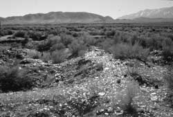 Figure 8.110. Manzanar Relocation Center landfill in 1994. |
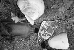 Figure 8.111. Typical artifacts at the Manzanar Relocation Center landfill. |
A 2-1/2-acre-area west of the relocation center cemetery was used for trash disposal when the relocation center closed. One area was used exclusively for the disposal of government-issued hotel ware ceramics (Figure 8.112), other areas were used for the disposal of large debris, such as vehicles, vehicle parts, concrete, and other items. Portions of at least ten partially buried vehicles are visible (Figure 8.113).
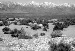 Figure 8.112. Ceramic disposal pit at the Manzanar Relocation Center. |
 Figure 8.113. Partially-buried evacuee automobile west of the Manzanar cemetery. |
Outlying Area
Other Features
 Figure 8.114. Evacuee-built oven 1/4 mile south of the central area. |
Remains at the evacuee parks south of the central area include two concrete ovens. One, 4 feet by 6 feet, is within a small, now roofless, one-room concrete and rock structure about 1/4 mile south of the central area (Figure 8.114). The oven, proportionally too large for the structure, was built by evacuees. The building itself is from a historical ranch that was in use from around the turn of the century until the mid-1930s. The other oven, of concrete and rock, was built by the evacuees within a two-room adobe-mortared rock building at an abandoned ranch 1 mile south of the central area. It is 5 feet by 7 feet in size with a 6-foot-high chimney.
There are some inscriptions carved into the clapboard siding of the Lone Pine train station (Figure 8.115). Six evacuees worked at the train station unloading materials destined for the relocation center. Only two of six known inscriptions (Garrett and Larson 1977) remain; others were stolen by removing the clapboard sometime in 1992, just after the depot was no longer watched by a caretaker (Bill Michael, personal communication, 1993).
A World War II-era airport was located just across U.S. Highway 395 from the relocation center central area. Built for the Army in 1941 for bomber pilot training, testing experimental aircraft, and aircraft emergencies, it apparently was never used by the relocation center. There are many features remaining at the airport including a powerhouse, a hangar foundation, a storage building foundation, an aircraft parking area, a wind-T support, two 5,000-foot-long asphalt-paved runways forming an X, a taxiway, and a small trash dump (Figure 8.116).
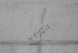 Figure 8.115. Inscription in the clapboard of the Lone Pine train station. |
 Figure 8.116. Oblique aerial view of the Manzanar airport today. |
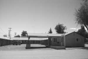 Figure 8.117. Barracks buildings at the Willow Motel in Lone Pine. |
At least fourteen relocation center buildings are still in the nearby towns of Independence and Lone Pine where they were moved after Manzanar closed. The condition of the moved structures is highly variable, but many still retain substantial architectural integrity. They include barracks, staff apartments, and the missing south wing of the auditorium (now the Lone Pine American Legion Hall). The Willow Motel in Lone Pine is made of three barracks buildings (Figure 8.117). Also in Independence are the decorative concrete gate posts originally at the relocation center entrance.
Interpretation
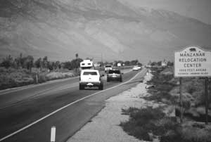 Figure 8.118. Sign along U.S. Highway 395. |
Manzanar is a registered State of California Historic Site, and is listed on the National Register of Historic Places as a National Historic Landmark. In 1992 Congress designated Manzanar a National Historic Site, and the National Park Service maintains a temporary office in Independence. Plans call for the restoration of the relocation center auditorium as an interpretive center, and possibly the reconstruction of a barracks and a watch tower. Driving and walking tours will tell the story of the relocation center while directing visitors to various features.
Along U.S. Highway 395 a sign points out the relocation center and there are turning bays for entering the site at the original entrance (Figure 8.118). At the entrance a State of California Historic Site marker has been added on to front (east) facade of the military police sentry post (Figure 8.119 and 8.120). On the back side of the sentry post there is a National Park Service information display. To the north of the sentry post there is a large granite boulder with a brass National Historic Landmark plaque (Figure 8.121); to the south there is a free-standing Blue Star Memorial Highway marker (Figure 8.122).
 Figure 8.120. Detail of the historical marker at the sentry post. |
One mile west of the entrance, the relocation center cemetery with its large memorial tower is the focus of the annual Manzanar Pilgrimage held the last Saturday of April (Figures 8.123 and 8.124). On the cemetery monument and graves visitors have placed assorted artifacts, most apparently from the nearby ceramic disposal pit, but the offerings also include historical artifacts from other areas, flowers, coins, and origami. There is a large graded parking lot adjacent to the cemetery. The current fence around the cemetery was put up by the Manzanar Committee in the 1980s. In 1994 an information board was placed at the cemetery by Derek Yemoto in honor of his interned grandparents as part of an eagle scout project (Figure 8.125)
The Eastern California Museum in Independence has an extensive display about the Manzanar Relocation Center, including artifacts and photographs (Figure 8.126). The museum maintains a comprehensive archive that includes World War II-era home movies taken at Manzanar. The museum also has the partial remains of a salvaged watch tower.
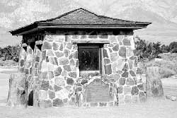 Figure 8.119. Historical marker at the military police sentry post. |
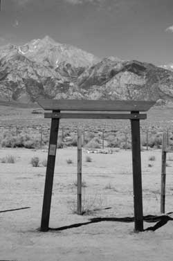 Figure 8.125. Framework for information board at the Manzanar cemetery. |
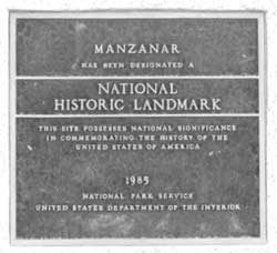 Figure 8.121. National Historic Landmark plaque, Manzanar. |
 Figure 8.122. Blue Star Memorial Highway marker. |
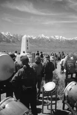 Figure 8.123. Manzanar pilgrimage. |
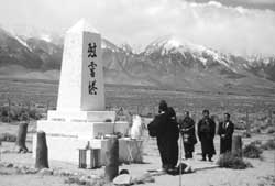 Figure 8.124. Manzanar pilgrimage. |
 Figure 8.126. Manzanar display at the Eastern California Museum in Independence. |
| <<< Previous | <<< Contents>>> | Next >>> |
wacc/74/chap8.htm
Last Updated: 20-Feb-2004