|
National Park Service
Confinement and Ethnicity An Overview of World War II Japanese American Relocation Sites |

|
Chapter 9
Minidoka Relocation Center
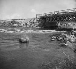 Figure 9.1. North Side Canal. (Francis Stewart photograph, Bancroft Library, University of California, Berkeley) |
The Minidoka Relocation Center was located in Jerome County, Idaho, 15 miles east of Jerome and 15 miles north of Twin Falls. The relocation center was also known as Hunt, after the official Post Office designation for the area, since there was already a town of Minidoka in Idaho, 50 miles east.
The relocation center lies within the Snake River Plain at an elevation of 4000 feet. The natural vegetation of this high desert area is dominated by sagebrush and other shrubs. Dominant geological features of the area are thin basaltic lava flows and cinder cones overlying thick rhyolite ash. The most notable topographic feature at the site is the wide meandering man-made North Side Canal (Figure 9.1). For the most part, the canal formed the southern boundary of the 33,000-acre relocation center reserve (Figure 9.2).
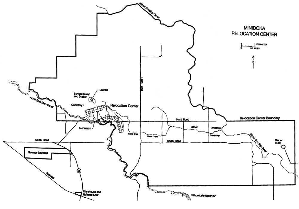 Figure 9.2. Minidoka Relocation Center. (click image for larger size (~48K) ) |
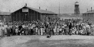 Figure 9.3. Residents of one barracks block. (from Minidoka Interlude 1943) |
Five miles of barbed wire fencing and eight watch towers surrounded the administrative and residential portions of the relocation center, which was located on 950 acres in the west-central portion of the reserve. Built by the Morrison-Knudsen Company, construction began June 5, 1942, and the relocation center was in operation from August 10, 1942 to October 28, 1945. The maximum population was 7,318; evacuees were from Oregon, Washington, and Alaska (Figure 9.3). In early 1943, all of the Bainbridge Island (Washington) residents interned at the Manzanar Relocation Center under the authority of the first Civilian Exclusion Order were moved to Minidoka. The transfer was at their own request, not only to be closer to their original home, but also because they were often at odds with their new neighbors from Terminal Island in Los Angeles.
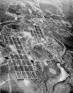 Figure 9.6. Oblique aerial view of the Minidoka Relocation Center. (from Minidoka Interlude 1943) |
There were over 600 buildings at the relocation center. Minidoka had an unusual layout due to the uneven terrain. At the other relocation centers, the barracks are all within a single large rectangular area subdivided into blocks, aligned on a single grid system. At Minidoka, the barracks blocks are in four separate groups following the arc of the North Side Canal, so that the block grids vary from the standard north-south orientation. Administration areas of the relocation center also were geographically separate, with their grids laid out at slightly different angles (Figures 9.4-9.6). There were 31 buildings in the administration and staff housing area, 19 buildings in a warehouse and motor pool area, 17 buildings at the hospital, and 15 buildings at the military police compound. Another unusual feature of the Minidoka layout is that although the residential blocks were numbered up to 44 not all numbers were used. Several blocks (for example, 9 and 11) never existed.
Each of the 35 residential blocks had 12 barracks, a mess hall, a recreation hall, and a central H-shaped building with bathrooms, showers, and a laundry. Also within the residential areas were four general stores, two dry-goods stores, two barber shops, a beauty shop, two mail-order stores, two dry cleaning stores, two watch repair stores, two radio repair shops, a check cashing service, two elementary schools, a health clinic, and two fire stations. A civic center, high school, and the evacuee-run community offices were centrally located in Block 23. In the vacant area between administrative areas and residential blocks were wells, a well house, and a sewage disposal plant.
 Figure 9.4. Minidoka Relocation Center. (National Archives) (click image for larger size) |
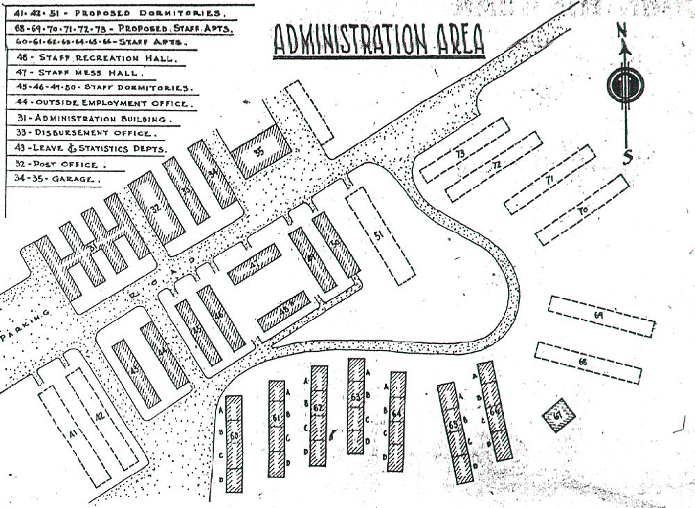 Figure 9.5. Administration area, Minidoka Relocation Center. (from Minidoka Irrigator 9/25/43) (click image for larger size) |
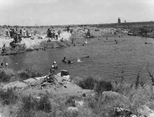 Figure 9.7. Swimming pool located south of warehouses. (WRA photograph, Bancroft Library, University of California, Berkeley) |
A gym was built by the evacuees adjacent to Block 23, and evacuees pursued outdoor sports as well. They constructed nine baseball diamonds, and in the winter water was diverted into a natural depression southeast of Block 44 for ice staking (Jim Kubota, personal communication, 1995). Swimming in the North Side Canal was common in the summer, however after a drowning accident, two swimming pools were constructed by the evacuees (Figure 9.7).
Evacuees constructed an irrigation canal to the relocation center from the Milner-Gooding Canal 5 miles east. Because of the topography the North Side canal could not used by the relocation center for irrigation without a costly pumping plant. Both the Milner-Gooding and North Side Canals had their takeout from the Snake River at Milner Dam 20 miles to the southeast. A total of 350 acres were cleared and farmed by the evacuees the first year. In 1943, 420 acres were under cultivation and in 1944 about 740 acres were planted. A variety of garden vegetables were grown in the fields, located mostly north and east of the fenced residential areas (Figure 9.8). Just outside the east side of the fenced residential area was a farm mess hall, a hog and chicken farm, and a landscaped park and picnic grounds watered with water initially hand-carried from a nearby canal.
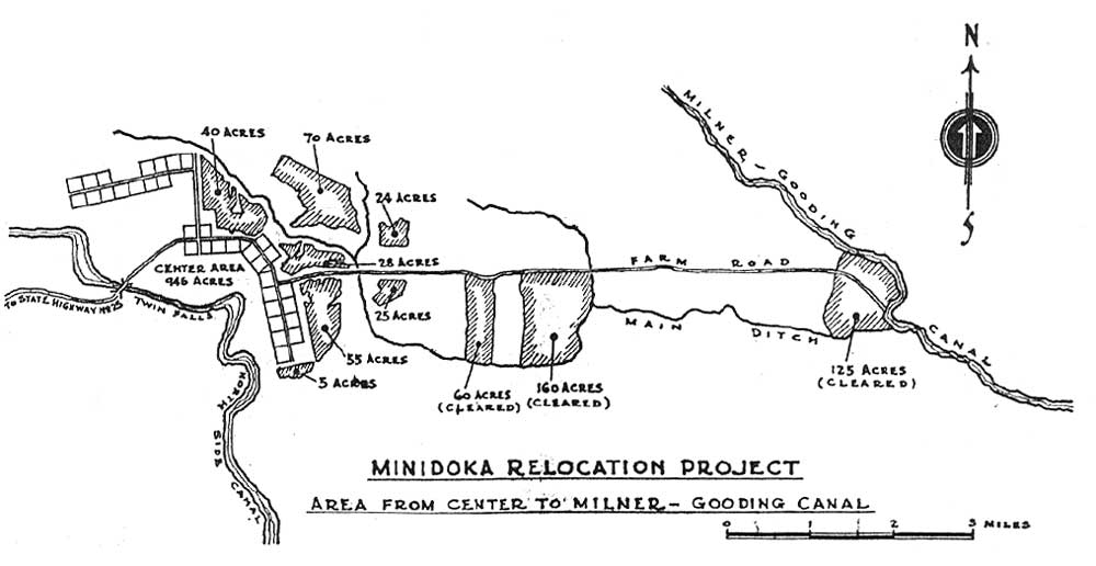 Figure 9.8. Farm fields at Minidoka. (from Minidoka Irrigator 7/21/44) (click image for larger size (~150K) ) |
A small cemetery was northwest of the central fenced portion of the relocation center (Yamaguchi 1989:41). When the relocation center was closed all of the bodies were exhumed and re-buried elsewhere. Some metal coffins remained and have been used for such things as feed and watering troughs.
Sewage lagoons were located about 2 miles southwest of the residential areas, on the other side of the North Side Canal. Also south of the canal, according to the WRA blueprints, there were a warehouse and railroad spur that served the relocation center.
After the relocation center was closed, the area was divided into small farms. Forty-three of these small farms were allotted in 1947 to World War II veterans, whose names were drawn in a lottery. In 1949 another 46 small farms were allotted. Each veteran also received two barracks. The first group of veterans lived in Block 30 of the relocation center until they could move their barracks to their own farms. The veterans and their families had to share the block's common bathroom and "some of the wives were upset to have to use community shower facilities" (Smith 1987), probably echoing the sentiments of the first, involuntary inhabitants.
Central (Fenced) Area
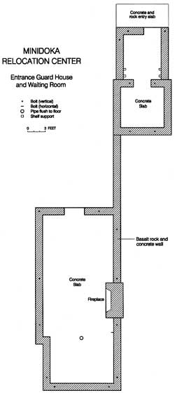 Figure 9.9. Plan map of guard house and waiting room at Minidoka. |
Only six acres of the former relocation center are currently public land. The Bureau of Reclamation manages a small parcel on the northeast side of the North Side Canal at the Hunt Bridge. The parcel includes the standing basalt and concrete walls of a guard house and waiting room, a small area across the road from the guard house that once was an ornamental garden (Lynne McDonald, Personal Communication, 1996), and historical markers. The waiting room has a large stone fireplace integral with the building's stone walls (Figures 9.9-9.12).
With a few notable exceptions, beyond the Bureau of Reclamation parcel little remains of the relocation center. Most of the central area is now cultivated fields of alfalfa, potatoes, and other crops (Figure 9.13). Concrete rubble from cleared building foundations has been pushed to the perimeter of many fields.
At least two buildings remain: Firehouse No. 1, which is now serves as a barn, and a root cellar, which is abandoned and in danger of collapsing (Figures 9.14 and 9.15). Adjacent to the root cellar are seven concrete slabs from buildings in the warehouse area (Figure 9.16). In the former administration area there is a concrete slab, with a rock alignment nearby. At least 100 feet long, the rock alignment may be the remains of a low wall or ditch. There is also a manhole, a rock alignment, and small concrete slab in the adjacent staff housing area (Figure 9.17).
Some of the farm houses and outbuildings in the central area appear to be recycled barracks or other relocation center buildings, but most have undergone extensive remodeling, with new siding and additions (Figure 9.18). The relocation center water wells appear to be still in use. The sewage disposal plant location is now a cultivated field.
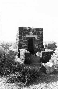 Figure 9.10. Guard house today. |
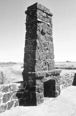 Figure 9.11. Chimney in waiting room. |
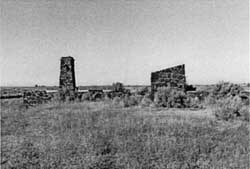 Figure 9.12. Guard house and waiting room. |
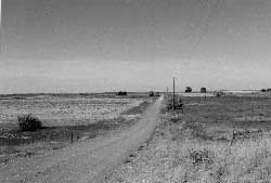 Figure 9.13. Residential area at the Minidoka Relocation Center today. |
 Figure 9.14. Root cellar under construction. (from Minidoka Interlude 1943) | |
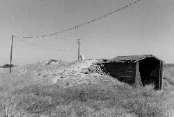 Figure 9.15. Root cellar at Minidoka today. |
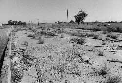 Figure 9.16. Concrete slab in warehouse area. |
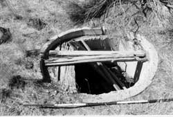 Figure 9.17. Manhole in staff housing area. |
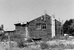 Figure 9.18. Typical reused barracks. |
Security Features
 Figure 9.19. Concrete slab reportedly for a searchlight. |
Of the security features at Minidoka only a portion of the barbed wire fence along the North Side Canal remains (Yamaguchi 1989:69). An unusual feature near the perimeter boundary fence location on the western edge of the residential area may have been security-related. It consists of a 10-foot-square concrete base that, according to a local resident, supported a searchlight used by the military police (Figure 9.19).
Outlying Features
The relocation center landfill, north of the residential area, consists of a large partially filled pit. Abundant remains there include many Japanese ceramics, a "Coke" bottle fragment from Fresno, California, and numerous smashed trash cans (Figures 9.20 and 9.21). Also present in the landfill vicinity is material apparently deposited after the abandonment of the relocation center, including building debris from field clearing, recently dumped trash, and a stripped vehicle. Some digging in the landfill by bottle collectors was apparent.
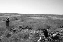 Figure 9.20. Minidoka Relocation Center landfill. |
 Figure 9.21. Japanese ceramics at the Minidoka Relocation Center landfill. |
The fields and canals made by the evacuees are still in use today. Basalt boulder and concrete "drops" constructed by the evacuees on the canal that supplied the relocation center farm fields are still in excellent condition (Figures 9.22 and 9.23). The farm workers mess hall and the hog and chicken farms are now cultivated fields.
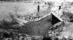 Figure 9.22. Canal drop under construction. (from Minidoka Interlude 1943) |
 Figure 9.23. One of seven canal drops at the Minidoka Relocation Center today. |
To the south of the relocation center, at the crossing of State Highway 25 and the Idaho Short Line Railroad is the railroad siding and warehouse area depicted on WRA blueprints. The area is overgrown with vegetation and covered with abundant 1950s and 1960s trash. However, the grade of the railroad spur and a leveled loading area are still apparent. Coal destined for the relocation center was apparently off-loaded onto trucks here, since copious amounts of coal residue cover the area.
Interpretation
 Figure 9.24. VFW hall in Jerome, Idaho. |
In Jerome, the County Historical Museum has a small but apparently very popular display on the relocation center. One of the volunteers there lamented that "people are more interested in [the relocation center] than the rest of the exhibits." Also of interest, the Veterans of Foreign Wars (VFW) building adjacent to the Museum was a mess hall moved from the relocation center (Figure 9.24).
East of Jerome on State Highway 25 at the turnoff to the relocation center site there is a large state historical marker (Figure 9.25). Within the relocation center itself, at the stone guard house and waiting room at the Hunt Bridge, there is a small gravel parking area, paths, and interpretative signs about the internment (Figures 9.26-9.29). Also commemorated here are the Japanese Americans from the relocation center who died serving in the military during World War II. Nearly 1,000 from Minidoka served in the army; Minidoka had the largest casualty list of the ten relocation centers.
A public ceremony was held at the site in 1979 when it was added to National Register of Historic Places (Conley 1982:198). The parking lot, paths, and interpretative signs were completed a few years after the ceremony (Turner 1989).
Recently, the Jerome County Historical Society has acquired two original Minidoka barracks and moved them to their in-progress "Idaho Farm and Ranch Museum" located 18 miles west of the relocation center site at the junction of Interstate 84 and U.S. Highway 93. One of the barracks will be used to interpret the relocation center and the other will be renovated for other uses (Asian American Comparative Collection Newsletter 16:2).
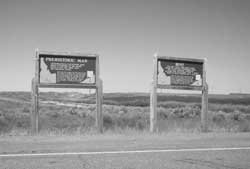 Figure 9.25. Historical markers at intersection of Hunt Road and State Highway 25. |
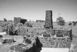 Figure 9.26. Historical markers at the guard house and waiting room. |
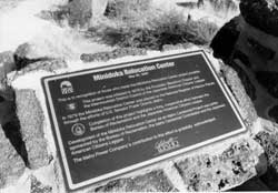 Figure 9.27. Detail of historical marker at guard house and waiting room. |
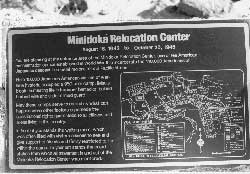 Figure 9.28. Detail of historical marker at guard house and waiting room. |
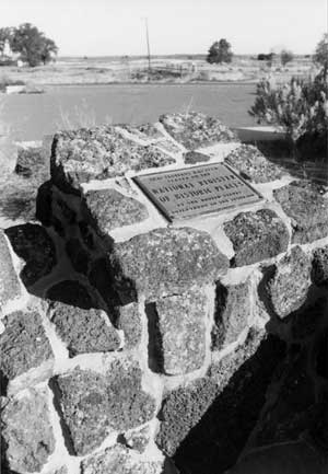 Figure 9.29. Detail of National Register plaque at guard house and waiting room. | |
| <<< Previous | <<< Contents>>> | Next >>> |
wacc/74/chap9.htm
Last Updated: 20-Feb-2004