The route chosen by the author for visiting the ruins
of the Navaho National Monument is via Flagstaff and Tuba, the distance
being not far from 200 miles to Marsh pass and 10 miles beyond to the
largest cliff-dwellings. Although the wagon road is long, requiring a
journey of at least five days, it may be traversed with carriage or
buckboard, the sandy stretch between Tuba and Red Lake being the most
difficult. The trail from Marsh pass to the great cliff-dwellings,
although now passable only on horseback, could be made into a wagon road
at small expense.
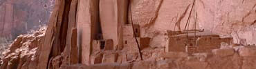
The nature of the cliffs in which the ruins of the
Navaho Monument are situated favored the construction of cliff-dwellings
rather than of open pueblos in this region. These cliffs are full of
caverns, large and small, presenting much the same condition as the
cliffs of the red sandstone elsewhere in the Southwest, as the Mesa
Verde, Canyon de Chelly, the Red Rocks south of Flagstaff, and other
sections where caverns abound. Fragments of fallen rocks present good
plane surfaces for walls of masonry, and there is abundant clay for
plastering. Trees suitable for rafters and beams are not wanting. In
short, all conditions are favorable for stone and adobe houses in the
cliffs. The neighboring Sethlagini mesa is of different geological
formation; in it are no caverns, the mesa top is broad, and ruins
thereon are necessarily open pueblos. The effect of difference in
geological structure is nowhere more evident than in these adjacent
formations.
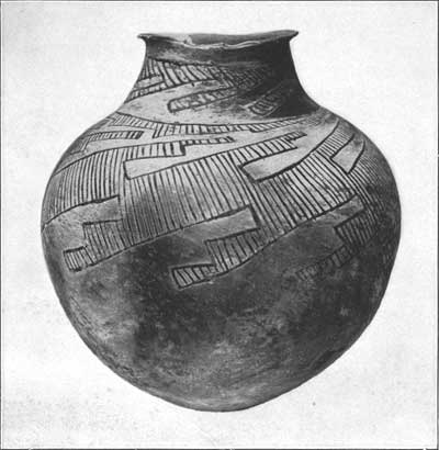
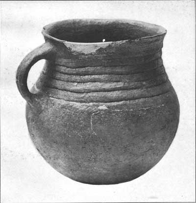
Plate 18. POTTERY FROM NAVAHO NATIONAL
MONUMENT (a large black-and-white vase [Cat No. 257774, height 17
inches] (top); b large vase with handle [Cat No. 257787, height
8-1/2 inches] (bottom))
|
If environment has had so marked an influence on the
character of building, we can readily see how it has affected arts and
crafts. We can hardly imagine a people living any length of time in this
region without being mentally influenced by the precipitous cliffs that
rise on all sides. The summits of these heights are eroded into
fantastic shapes resembling animals or grotesque human forms. The
constant presence of these marvelous forms, of awe-inspiring size and
weird appearance, exerted a profound influence on the supernatural ideas
of the inhabitants. Here were born many conceptions of earth gods and
the like, survivals of which still remain among the Hopi.
As a rule the cliff-houses are not situated in sight
of the main stream, but are hidden away in secluded side canyons,
approached by narrow entrances, their sites having been determined no
doubt by the position of the springs with their constant water
supply.
Almost every side canyon, even in a dry season, has
its spring of water which, trickling out of the rocks, follows the
canyon bed until it is finally drunk up by the thirsty sands. Often
water seeps out of a soft stratum of rock in the cave itself, where it
was gathered in artificial reservoirs that in ancient times furnished an
adequate supply for the inhabitants. One feature of these side canyons
is that they enlarge into basins surrounded on all sides by lofty
cliffs. Many of these basins are so hidden that they can be discovered
only by following dry stream-beds from their junction with the creeks.
How many of these basins are still undiscovered no one can yet tell. In
these basins now covered with bushes the aboriginal farms were probably
situated.
As the width of the valley of Laguna creek from Marsh
pass to the point where the stream receives its largest branches on the
left bank varies, the amount of arable land is greater in some places
than in others. In stretches where the stream almost washes the bases of
the ruins there could have been no extensive farming lands. The creek
meanders through the soft clay and sand which fill the valley to the
depth of many feet, forming treacherous banks that are continually
falling and changing the course of the stream, so it is quite possible
that the present configuration of the valley is very different from what
it was when the cliff-dwellings were inhabited. If the occupants once
had farms within its limits all traces of them would have long since
been obliterated. Although too much credence should not be given to
Navaho traditions, it is not unreasonable to believe that in one
particular at least they are correct. These state that, before the
introduction of sheep, grass was much higher in the level part of the
valley than at present, and formerly game (at least the mountain sheep
and the antelope) may have been more abundant. This condition would have
exerted a marked influence on the life of the cliff-dwellers.
Pictographs show that the ancient people, either here or in their former
homes, were familiar with these animals, and various objects of bone and
horn are significant in this connection.
The Navaho National Monument (see sketch map, pl. 22)
contains two kinds of ruins,a cliff-dwellings and pueblos. Most
of the latter are situated on promontories or on low hills. The
structural features of the cliff-dwellings are characteristic, their
walls being constructed of stone or adobe built against, rarely free
from, vertical faces of the cliff.
aThe writer was not able to determine the exact site of the
traditional Tokonabi, but believes one is justified in considering the
ruins visited to be prehistoric houses of the snake (Flute), Horn, and
other Hopi clans whose descendants now live in Walpi.
There are two types of kivas, one circular and
subterranean, allied to those of the Mesa Verde, the other rectangular,
above ground, entered from the sides.
The masonry of these northern ruins is crude,
resembling that of modern Walpi. The component stones are neither
dressed nor smoothed, but the walls are sometimes plastered. There is a
great similarity in architecture. No round towersb relieve the
monotony or impart picturesqueness to the buildings. The walls of ruined
pueblos in this region and the ceramic remains closely resemble those at
Black Falls on the Little Colorado. A prominent feature of the walls is
a jacal construction in which the mud is plastered on wattling
between upright poles. The ends of many of these supports project high
above the ground, constituting a characteristic feature of the ruins.
This method of wall construction is unknown at Black Falls or at Walpi,
but survives in modified form in one or more Oraibi kivas and in one at
least of the Mesa Verde ruins.c It has been described by Mr.
Cosmos Mindeleff as common to several ruins in the Canyon de Chelly.
b While circular subterranean kivas are found in some of the
ruins, none of these have the six pilasters so common higher up on the
San Juan, nor hove these rooms ventilators like those of Spruce-tree
House. Some of the ruins have rectangular kivas, above ground, entered
from one side.
cThe best example of walls of this kind is found in an
undescribed cliff-ruin in the canyon southwest of Cliff Palace.
The key to the culture of the people from which the
cliff-dweller culture was derived is probably the kiva, which furnishes
also a good basis for the classification of the Pueblos and
cliff-dwellers into subordinate groups.
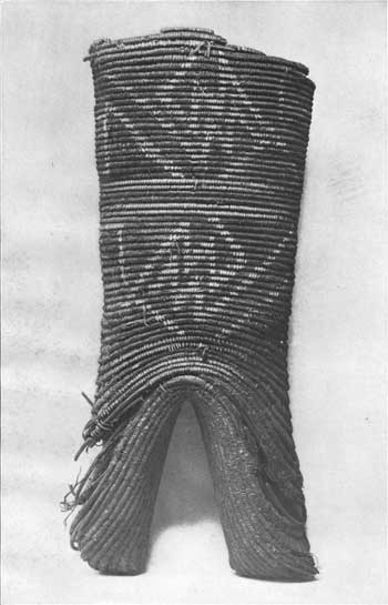
Plate 19. CLIFF-DWELLERS CRADLE—FRONT
(Dimensions; length, 22 inches; breadth, 9 inches; diameter, 6
inches)
|
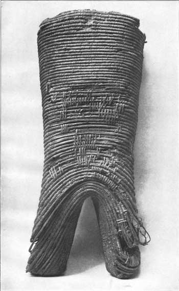
Plate 20. CLIFF-DWELLERS CRADLE—REAR
|

Plate 21. CLIFF-DWELLERS CRADLE—SIDE
|
Architecturally the kiva reached its highest
development in the Mesa Verde region, where it is a circular
subterranean room with pilasters and banquettes, ventilators and
deflectors, fireplaces and ceremonial openings, the features of which
have been described elsewhere. As we follow the San Juan down to its
junction with the Colorado we find a gradual simplification of the
circular type of kiva by the elimination of pilasters, ventilators, and
other features, the round kiva being here represented by rooms in which
almost the only architectural feature remaining is the large banquette.
The question naturally arising in this connection is, whether the
circular kiva in the eastern region is a development of that simpler
form existing in the western or whether the latter is a degenerate form
of the eastern. In other words, does the evidence show that this
particular modification spread from the east down the San Juan or from
the west up the river to the east? In this connection it may be urged
that originally the form of circular kiva lacking pilasters extended
along the entire course of the San Juan and that the kivas of the Mesa
Verde became highly specialized forms in which pilasters were developed,
while those lower down the river remained the same. We can not
definitely answer either of these questions, but taken with other
evidence it would seem that the circular form of kiva originated in the
eastern section and gradually extended westward.
The modern Hopi rectangular form of ceremonial room
situated underground seems in some instances to have derived certain
features from the circular subterranean kiva.
The chief kiva at Walpi, that used by the Snake
fraternity, is rectangular and subterranean, while that used by the
Flute priests, which is practically a ceremonial room, is a chamber
entered by a side doorway. It is suggested that the Snake kiva at Walpi
was derived from the circular subterranean kiva of Tokonabi, the former
home of the Snake clan in northern Arizona, and that the Flute chamber
was developed from the rectangular rooms in the same ruins. The old
question, so often considered by Southwestern archeologists, whether the
circular subterranean kiva was derived from the rectangular or vice
versa, seems to the writer to be somewhat modified by the fact that
ceremonial rooms of both forms exist side by side in many ancient
cliff-dwellings. From circular subterranean kivas in some instances
developed square kivas, but the latter are sometimes the direct
development of square rooms; the determination of the original form can
best result from a study of clans and their migrations.a
>aIt is generally the custom to speak of the
rectangular subterranean rooms of Walpi as kivas, while the square or
rectangular rooms above ground, in which equally secret rites are
performed, are not so designated. Both types are ceremonial rooms, but
for those not subterranean the term kihu (clan ceremonial room), instead
of kiva, is appropriate.
Naturally the questions one asks in regard to these
ruins are:
Why did the inhabitants build in these cliffs? Who
were the ancient inhabitants? When were these dwellings inhabited and
deserted?
It is commonly believed that the caves were chosen
for habitations because they could be better defended than villages in
the open. This is a good answer to the first question, so far as it
goes, although somewhat imperfect. The ancients chose this region for
their homes on account of the constant water supply in the creek and the
patches of land in the valley that could be cultivated. This was a
desirable place for their farms. Had there been no caves in the cliffs
they would probably have built habitations in the open plain below. They
may have been harassed by marauders, but it must be borne in mind that
their enemies did not come in great numbers at any one time. Defense was
not the primary motive that led the sedentary people of this canyon to
utilize the caverns for shelter. Again, the inroads of enemies never led
to the abandonment of these great cliff houses, if we can impute valor
in any appreciable degree to the inhabitants. Fancy, for instance, the
difficulty, or rather improbability, of a number of nomadic warriors
great enough to drive out the population of Kitsiel, making their way up
Cataract canyon and besieging the pueblo. Such an approach would have
been impossible. Marauders might have raided the Kitsiel cornfields, but
they could not have dislodged the inhabitants. Even if they had
succeeded in capturing one house but little would have been gained, as
it was a custom of the Pueblos to keep enough food in store to last more
than a year. In this connection the question is pertinent. While
hostiles were besieging Kitsiel how could they subsist during any length
of time? Only with the utmost difficulty, even with aid of ropes and
ladders, can one now gain access to some of these ruins. How could
marauding parties have entered them if the inhabitants were hostile? The
cliff-dwellings were constructed partly for defense, but mainly for the
shelter afforded by the overhanging cliff, and the cause of their
desertion was not due so much to predatory enemies as failure of crops
or the disappearance of the water supply.
The writer does not regard these ruins as of great
antiquity; some of the evidence indicates that they are of later time.
Features in their architecture show resemblances derived from other
regions. The Navaho ascribe the buildings to ancient people and say that
the ruined houses existed before their own advent in the country, but
this was not necessarily long ago. Such evidence as has been gathered
supports Hopi legends that the inhabitants were ancient Hopi belonging
to the Flute, Horn, and Snake families.
There is no evidence that cliff-house architecture
developed in these canyons, and rude structures older than these have
been found in this region. Whoever the builders of these structures
were, they brought their craft with them. The adoption of the deflector
in the rectangular ceremonial rooms called kihus implies the derivation
of these rooms from circular kivas, and all indications are that the
ancient inhabitants came from higher up San Juan river.
Many of the ruins in Canyon de Chelly situated east
of Laguna creek show marked evidence of being modern, and they in turn
are not so old as those of the Mesa Verde. If the ruins become older as
we go up the river the conclusion is logical that the migration of the
San Juan culture was down the river from east to west, rather than in
the opposite direction. The scanty traditions known to the author
support the belief in a migration from east to west, although there were
exceptional instances of clan movements in the opposite direction. The
general trend of migration would indicate that the ancestral home of the
Snake and Flute people was in Colorado and New Mexico.
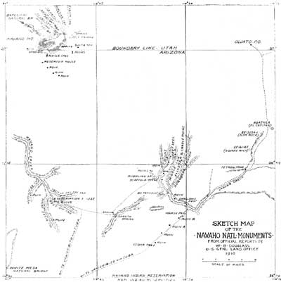
Plate 22. SKETCH MAP OF THE NAVAHO NATIONAL
MONUMENTS (click on image for an enlargement in a new window)
|
It is evident from the facts here recorded that the
ruins in the Navaho National Monument contain most important, most
characteristic, and well-preserved prehistoric buildings, and that the
problems they present are of a nature to arouse great interest in them.
Having suffered comparatively little from vandalism, these are among the
best-preserved monuments of the cliff-dwellers' culture in our
Southwest, and if properly excavated and repaired they would preserve
most valuable data for the future student of prehistoric man in North
America. It is not necessary to preserve all the ruins within this area,
but it would be well to explore the region and to locate the sites of
the ruins that it contains.