|
PIPE SPRING
Cultures at a Crossroads: An Administrative History |

|
PART X - PIPE SPRING NATIONAL MONUMENT COMES ALIVE (continued)
Planning and Development with the Kaibab Paiute Tribe and Associated Water Issues
Aside from those changes referenced in the earlier "Monument Administration" section, very few changes to the monument's physical plant took place from 1964 to 1970. Monument staff worked on preparing chapters for the monument's master plan in 1964 and 1965. No visitor center or nature trail constructed was constructed under the Mission 66 program, due to lack of funds. The trailer office continued to be used until the visitor contact station was installed at the monument in early 1968 (referenced earlier). An important shift in the monument's planning and development activity during this time period was the evolution of a closer working relationship between monument staff and the Kaibab Paiute Tribe. This shift was prompted by a number of synchronous events: the completion of State Highway 389, the availability of financial resources and planning assistance to the Tribe to enable them to develop tourism-based facilities, and the Park Service's own desire to carry out planning goals during a period of tight fiscal restraints. The Park Service's willingness to cooperate with and assist the Tribe to attain their goals was also spurred by a concern over protecting monument resources, including its "historic scene."
The monument's early efforts in the 1960s to forge cooperative agreements with the Tribe got off to a rocky start. After the tri-partite water agreement of 1933, it was another 30 years before the next agreement of a cooperative nature was executed between the monument and the Kaibab Paiute Tribe. Even then, the agreement was plagued with problems. In late 1963 Tribal Chairman Vernon Jake gave the monument permission to use the Tribe's newly dug garbage pit near Kaibab Village. (According to Management Assistant Hugh Bozarth, the Tribe originally dug this pit at his urging.) In February 1964, however, the Tribe indicated they expected the Park Service to share in the pit's maintenance expense. At Superintendent Oberhansley's direction, Bozarth drafted an agreement stating that the Park Service would share in trash pit maintenance. That seems to have been an amicable arrangement at the time. Almost one year later, however, in January 1965, the Tribe informed Bozarth that a fee of $15 per month would be charged for use of their garbage dump site. Bozarth was taken aback by the request and immediately began looking for another site to dispose of monument refuse. He learned in February that Fredonia officials would allow the use of the town's dump for a fee of $25 per year (as opposed to the tribal fee, which amounted to $180 per year). Bozarth contacted the Tribe and asked about continuing the joint-maintenance agreement of the dumpsite as opposed to paying a monthly fee but a response was very slow in coming. Meanwhile, the monument used Fredonia's dumpsite while awaiting a reply from the Tribal Council. In March Bozarth learned that certain Moccasin residents were dumping their trash into the Tribe's dumpsite with neither permission nor payment. "This is none of our business, but such are their relationships," he informed Zion officials. [1976]
In November 1965 Bureau of Indian Affairs (BIA) official Harry Dohm of Gallup, New Mexico, visited the monument and reservation to mediate a settlement between the monument and Tribe over the use of the reservation dumpsite. In December the Tribal Council met and discussed the matter but no decision was reached. By early 1966 they were offered the rate of $5 per month to use the reservation dump, which Bozarth agreed to pay. Even though the total of $60 per year exceeded the $25 a year he was then paying the town of Fredonia, it was worth not having to drive 15 miles to Fredonia to dispose of the monument's garbage.
From time to time, there were interactions between the Tribe and monument personnel on other topics. In connection with the construction of State Highway 389, Bozarth reported in February 1964 that the Tribe was considering setting up a trading post at the intersection of State Highway 389 and the road leading to the monument. Vernon Jake indicated that the post would be Indian-owned with someone contracted to operate it. As mentioned earlier, Bozarth suggested to Jake about this time that the Tribe consider building a camping area for visitors.
In April 1966 Bozarth reported that as the completion of the rerouted State Highway 389 approached, the Tribe was making plans to "establish a public service of some sort at the Moccasin intersection near the monument." [1977] Bozarth pointed out to Zion officials that any such development by the Tribe would require culinary water from Pipe Spring, not just the pond water from which their present share was derived. Such a situation would impact the water distribution method that had been in place since the three-way division box was installed in the summer of 1934. Bozarth wrote that the monument's water collection box (beneath the fort's parlor floor) was barely adequate to meet the monument's needs for culinary water. He supported the Tribe's desire to offer services that met a public need, and again encouraged tribal officials to consider putting in a camping area and a trading post.
The first formal notification of the Tribe's development plans came in the fall of 1967. Tribal Chairman Vernon Jake wrote a brief letter on October 18, 1967, to Superintendent Hamilton informing him of the Tribe's development plans:
With the recent completion of Arizona State Highway 389, the Kaibab Paiute Tribal Council is now concerned with development of tourist facilities near Pipe Springs National Monument.
We plan to develop several facilities including a campground, service station, restaurant, grocery and curio stores, and possible a motel. Additional traffic generated by completion of this highway will undoubtedly create a need for further development of Pipe Springs National Monument.
In order that both NPS and Tribal development projects be compatible, we request that you let us know what you have programmed for the monument. [1978]
Hamilton responded two weeks later, praising the Tribe's development plans as "a very worthwhile endeavor" that would meet area visitor needs. He wrote that while the principal development planned by the monument was to improve its interpretive facilities, there were other concerns:
We hope to obtain a Visitor Center where information could be provided to the visiting public and some of the exhibits would be displayed for better interpreting the history of the Fort. We would hope to eventually have more people on the staff with the increase in travel, and this would require some additional housing. As you perhaps know, with our limited space we are now discouraging camping on the Monument and will eventually restrict the site to picnicking only. We certainly do not plan to develop any facilities such as the types you are considering.
I certainly hope your plans to develop the tourist facilities will become a reality. If we can be of any assistance to you we will be glad to do so... [1979]
Hamilton offered to meet with Vernon Jake at Pipe Spring to further discuss the Tribe's plans. The matter was discussed at the November 1, 1967, Zion staff meeting. It was brought up that "some time back" there had been talk of the Indians needing a larger share of water from Pipe Spring should they actually carry out their development plans. Park Service officials opined at the meeting that the Tribe "should have enough water with their present one-third share if they made provision for proper storage of the water." [1980] By 1969, however, it would be quite apparent that they were wrong in making that presumption.
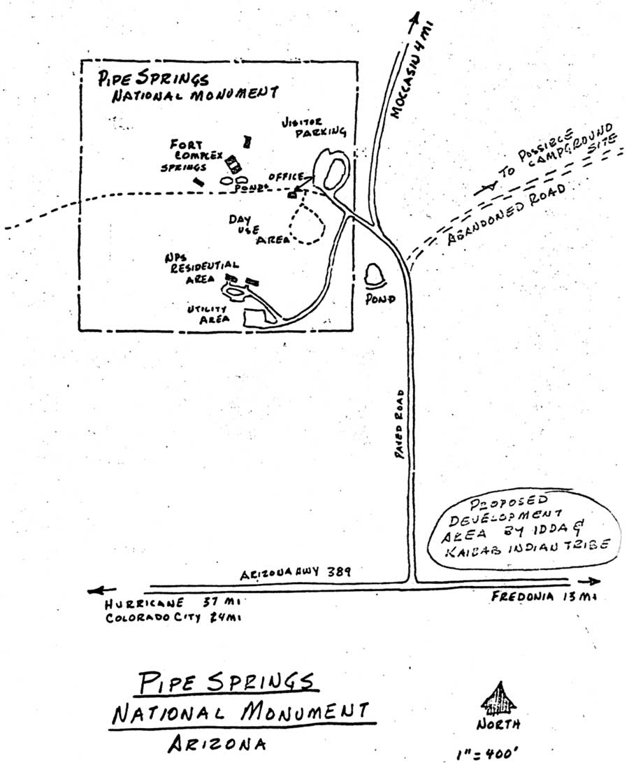
The Tribe's development plans were in large part driven by the availability of economic aid from the Economic Development Administration (EDA) which had an office located in Santa Fe. The EDA funds were funneled to various tribes through the Indian Development District of Arizona (IDDA), an NPS-administered program which functioned to assist tribes in developing and improving their economic and social well being. (IDDA was not connected to the BIA.) IDDA staff assisted the tribes with planning, design, and production of construction drawings. [1981] On December 7, 1967, Guy McIntosh, Ernest Rice, and Bill Tom of the BIA visited Pipe Spring with Tribal Chairman Vernon Jake. They discussed with Jim Harter future development plans for tourist facilities near the monument. At the request of IDDA's Project Planner Gene Griffin, a meeting was held on March 20, 1968, between Superintendent Hamilton, Landscape Architect Gene Switzer (Lake Mead National Recreation Area) and Griffin at Pipe Spring to discuss the Tribe's proposed developments. Funds came from tribal contributions and from IDDA. Preliminary plans proposed placing a campground and other developments at the intersection of State Highway 389 and the spur road to the monument, located immediately north of the highway. There was also some discussion about the possibility of a motel but this would be "sometime in the future," Hamilton reported to Regional Director Beard. [1982]
Switzer sent a more detailed report of the meeting to the Design and Construction Office, San Francisco Service Center, which included a sketch map showing the location of proposed developments. [1983] He reported that a Phoenix architectural firm (which had never seen the site) had drawn up sketches of a proposed complex that included an 80-100 unit motel, curio store, cafe, a service station, and a pay campground-trailer complex. Very little research had been done in planning the whole proposal, Switzer wrote. There were no master plan, topographic maps, aerial photos, or feasibility studies, to base plans on. Griffin indicated that IDDA did not want to ask the BIA for assistance. Switzer reported,
In our discussions we tried to diplomatically emphasize that the NPS did not intend to discourage them in a development but that the NPS was not in favor of it being located adjacent or in close proximity to the monument. It was felt that a commercial development would cheapen the historical values, the impact and impression to the visitor upon entering the facility, as well as his views to the outlying open countryside.
Our recommendations were that if the development became a reality it should be located to the east of the intersection...
After viewing several possible sites for a campground complex a location about one-half mile to the east of the monument was suggested.... It would require very little site preparation and is out of sight of the highway and monument but close enough to provide the visitor a panoramic view of the countryside and a trail system to the monument.
Water to the site would be derived from the [Indian] pond near the monument entrance and would have to be delivered through a pressure system. [1984]
Switzer pointed out that State Highway 389 was being used as a shortcut to the North Rim of the Grand Canyon and to Glen Canyon National Recreation Area from Interstate 15. Still, he could hardly imagine the large-scale developments being planned by the Tribe as a "paying proposition" in such a remote area. "The Monument itself or the reservation are not or have not been that great an attraction," he pointed out. Switzer agreed to assist the Tribe in the planning process as his time permitted, by providing information about technical matters pertaining to the preparation of a study, master plan, federal standards, etc. He informed them, however, that he could not actually prepare the master plan, renderings, and working drawings himself, as Griffin had hoped.
Discussions about tribal development plans continued after the arrival of Ray Geerdes to the monument in late April 1968. In May Zion's Chief of Maintenance Joe Davis and Civil Engineer Denny Galvin (Southwest Region) visited to look over the monument's water situation. In July three BIA officials also visited the monument while investigating the Tribe's proposed commercial developments.
118. Sketch map showing initial area proposed
to locate Indian developments, April 1968
(Pipe Spring National Monument).
(click on image for an enlargement in a new window - ~72K)
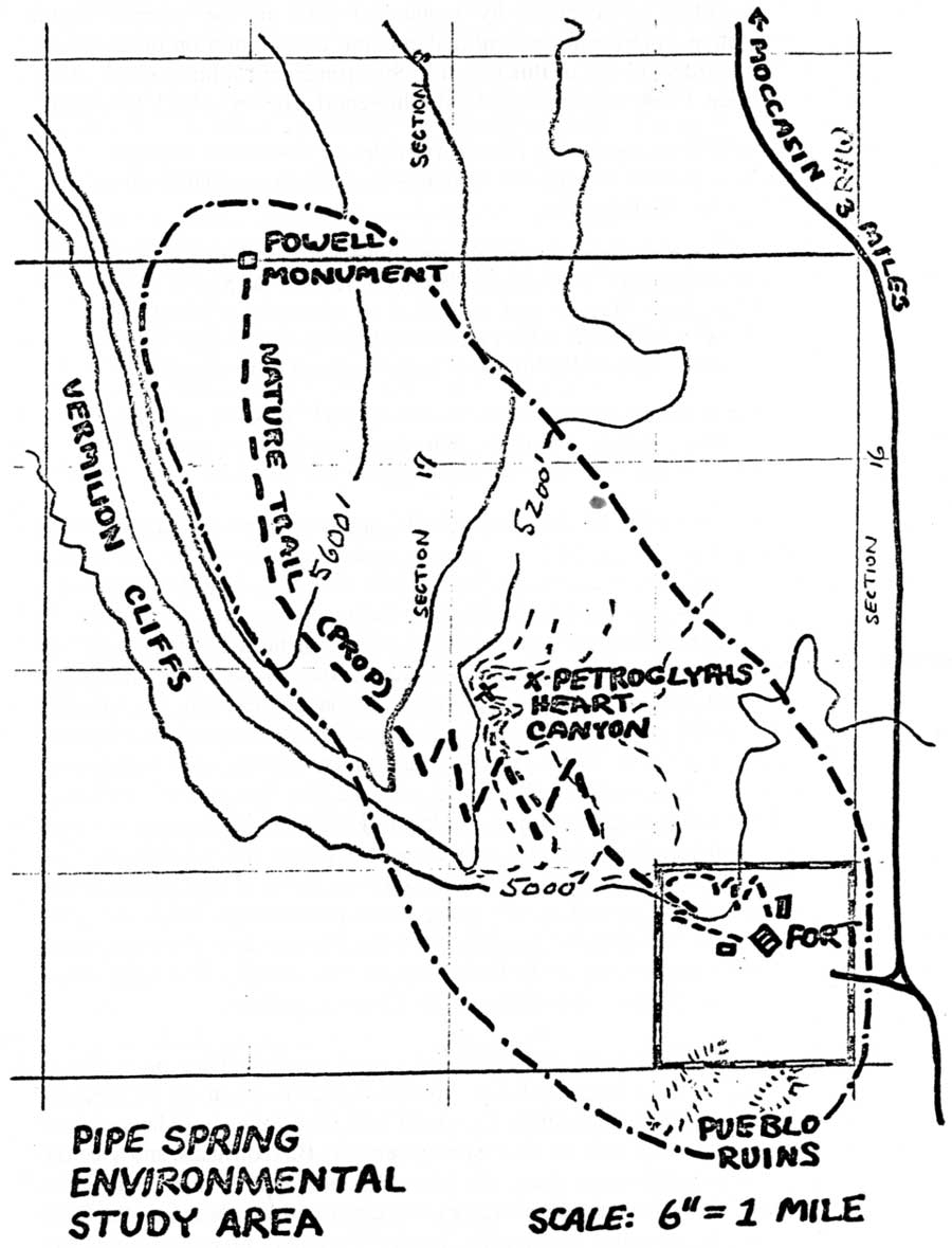
On July 13, 1968, Ray Geerdes wrote Superintendent Gilbert about an Environmental Study Area Inventory for the monument. He had received permission from Vernon Jake to include several areas within the reservation boundaries in the park's environmental education interpretive program. These areas were the Pueblo ruins south of the fort, the Heart Canyon petroglyph area, and the Powell survey monument north of the fort. Jake also agreed to allow a way trail that connected these areas to Pipe Spring National Monument's new nature trail. Geerdes felt these features belonged within the monument and he had approached Jake about the idea of the Park Service acquiring these lands. Geerdes reported,
When Mr. Jake was here the other day I discussed the general ideal [sic] with him of acquiring these areas. From this discussion I concluded that Mr. Jake is very receptive to the idea and would consider a land exchange for BLM land adjacent to the reservation. The economic value of the area outlined is almost nil as far as grazing land is concerned, but would be of tremendous value in interpreting the area. I would like to discuss this in detail with you at the first opportunity. [1985]
No records of further correspondence or discussion on this proposal are found for 1968, but the issue would be revived in late 1969.
On January 10, 1969, two men from the Phoenix BIA office, Architect George M. Causland and Engineer Victor Lund, visited the monument in connection with a proposed tribal office building. Originally, Geerdes and Vernon Jake planned to go Flagstaff that day to talk with Andy Sandaval about NYC issues. [1986] When Geerdes cancelled out (presumably to attend to the BIA meeting), Jake made other plans. On that day (January 10), a terrible accident occurred. Vernon Jake and three others -Fredonia's Mayor Arland Brooksby, Fredonia policeman Eldon Johnson, and Merrill ("Buddy") Button - were killed when their small plane crashed near Fredonia. The group was returning from a Soil Conservation Service meeting in Kingman, Arizona. All monument personnel attended the group funeral, which was held in Kanab. [1987] Bill Tom succeeded Vernon Jake as tribal chairman.
In late February, at the request of Gilbert, Geerdes prepared a summary of the monument's contacts and relations with local Paiute and Navajo. He reported that on February 12, 1969, IDDA Assistant Director Frank H. Carson spent a day at Pipe Spring explaining "all the possible Indian Development plans." [1988] The role played by IDDA in tribal developments was somewhat puzzling at that point to Geerdes who added,
What his relationship is with Mr. Gene Griffin, also of the IDDA... is not clear. In fact, the exact relationship of the IDDA and the BIA and local tribe is anything but clear. We were courteously cooperative, but I do have certain reservations about the promotional nature of this organization, its representatives, and their relationship to the above mentioned groups. [1989]
119. Sketch map showing general area Park
Service proposed to acquire from the Kaibab Paiute Tribe through land
exchange, 1968
(Pipe Spring National Monument).
(click on image for an enlargement in a new window - ~109K)
Geerdes also described involvement by monument staff in the summer youth programs, cooperation in law enforcement matters, and cooperation on development issues. Gilbert forwarded a copy of this report to Superintendent John E. Cook of the Navajo Lands Group. Cook was impressed with the report. He wrote back to Gilbert,
I certainly commend Supervisory Historian Geerdes for an excellent summary [of contacts with local Indians] and what appears to be an excellent feeling toward the local Indian people.
I particularly wish to commend him for his astuteness in acquiring 'certain reservations' about IDDA. Mr. Frank H. Carson was recently the Navajo Tribal Parks & Recreation Director and succeeded in adversely affecting our relationships with the Navajo Tribe. I recommend 'due caution' when dealing with or around Mr. Carson (I'll fill you in further in Santa Fe next week).
You might have Geerdes continue with this Navajo NYC as is and steer clear of the reservation program. It is quite political and unpredictable now and it sounds to me as if you've already a good thing going at Pipe Springs. [1990]
Over the winter of 1968-1969, the Tribe began building homes as part of a new housing project at Kaibab Village. [1991] The BIA construction superintendent was short of workers and asked Geerdes in February if he would loan some of his NYC boys for the housing project. Tim Rogers was reassigned permanently to the housing project. (Application to the Flagstaff office to refill Rogers' slot at the monument was turned down. Monument personnel were informed that the area was over its quota. Another attempt to hire an out-of-school youth that spring resulted in a heated exchange between the Flagstaff coordinating office and Geerdes. [1992] Another serious conflict arose that summer between Geerdes and Flagstaff officials over the latters' refusal to pay enrollees they had dropped from the program. [1993] ) One day a week, Geerdes released five Navajo NYC workers to work on the Kaibab Village housing project. By July two Park Service representatives sat on the Paiute-Kaibab Housing Authority, a five-member group, with Geerdes as vice-president and Mel Heaton as secretary. The organization supervised the construction of housing on the reservation as well as new water works construction. While the Tribe, BIA, and IDDA oversaw housing construction, this particular water development project on the reservation would primarily be the Park Service's responsibility. That is the reason for the participation by Geerdes and Heaton on the Housing Authority.
On April 6, 1969, Karl T. Gilbert was appointed general superintendent of the newly established Southern Utah Group (SOUG). Administrative oversight of Pipe Spring National Monument was transferred from Zion to SOUG. That following May and June a number of meetings were held at Pipe Spring between BIA officials and Geerdes regarding the Tribe's development plans. On May 13 Albert R. ("Al") Purchase, BIA Lands Operations Officer from the Hopi Agency at Keams Canyon, discussed the BIA's building plans and future water needs with Geerdes. Purchase advised Geerdes that construction of the tribal office building was to begin in the fall of 1969, just three months later. The new 3,000 square foot building was to have public restrooms and showers. It was estimated that the building's water usage would vary between 2,000 and 5,000 gallons per day. Development plans for a motel, store, filling station, and campground complex were scheduled at that time for the spring of 1970. Geerdes phoned Gilbert that day informing him of the situation. [1994] Al Purchase phoned Gilbert the following day formally advising him of the Tribe's plans to construct the office building.
On May 16, 1969, Gilbert sent a memorandum to Regional Director Kowski regarding the Tribe's development plans and his concerns about the impact on water use at Pipe Spring. Recall that the monument had yet to develop a modern water system, although one had been planned for many years. In his memorandum to Kowski, Gilbert raised several questions:
An expansion and updating of the present Pipe Spring water system is programmed for the near future. The question now comes to mind as to the advisability of a joint NPS-BIA system. Should this be considered? Are there advantages or disadvantages to it? This utilization of a single spring in the development of two separate water systems of considerable size certainly offers problems. [1995]
No event since the early 1930s had created such an immediate need to reappraise the monument's water situation, nor posed more of a threat to a mutual agreement that had been unchallenged and in place for 36 years. Up to this point, water to the Tribe had been provided from the fort ponds, water used by them primarily for stock watering and secondarily for irrigation, not for culinary use. Thus it was not only the increased amount of water needed by the Tribe that necessitated a change in the old arrangement but the kind of water needed. After conferring with Gilbert it was decided that Geerdes would check with the regional office and San Francisco Service Center regarding both the monument's requirements for water and the possibility of establishing a cooperative arrangement with the Tribe. On June 16, 1969, Geerdes received an unexpected visit in the late afternoon by BIA Plant Manager George Easton (also from Keams Canyon) and local Paiute officials. According to Geerdes, Easton "demanded to know where the new BIA water tank and line could be laid." [1996] Geerdes reported the visit to Gilbert that day. On June 18 Gilbert and Joe Davis traveled to Pipe Spring to inspect the monument's water supply in order to prepare a response to Easton's demand for immediate information.
By July 1969 tribal development plans brought the matter of water at Pipe Spring to a point of "critical reappraisal," reported Geerdes. [1997] Materials were being stockpiled for the Tribe's new office building. On July 2, 1969, a meeting was held at Pipe Spring to discuss the water distribution problem. It was attended by Karl Gilbert, Joe Davis, Jim Schaack, Bill Fields, and Ray Geerdes. [1998] Fields later wrote regarding the tribal office building, "the plans were drawn, the contract was let, and preconstruction conference held without firming [up] any plans for water for the building." [1999] It was obvious that the Tribe's one-third allotment from Pipe Spring would not meet the demands of its proposed developments. Gilbert, Davis, Schaack, Fields, and Geerdes agreed that the ideal solution would be to drill one or more wells to serve as the primary source for culinary water. Fields volunteered to request a USGS study from the Water Rights Division and ask them to schedule a test well. Fields later wrote,
It was also agreed that we should 'lay it on the line' to the Indians and BIA and attempt to work out something mutually beneficial on the spot without resorting to a discussion of legal ramifications. We will point out to them that without this spring flow there would be no Monument and without the Monument there would be little use for their complex. [2000]
There was another reason the Park Service wanted to cooperate with the Tribe on the development of a joint water system. Use of the main spring for culinary water by monument staff was responsible for an undesirable situation: when the Park Service's culinary system was in operation, the spring did not flow through the spring room, due to insufficient flow. The entire system, Bill Fields concluded, needed to be rehabilitated if the monument was to continue its use of the spring for culinary water. "Of course, if we can get culinary water from another source then the original system will work much better..." wrote Fields. [2001] A formal request from the regional office to the supervisory hydrologist, San Francisco Service Center, for a USGS study of the ground water situation was made on July 11, 1969. A request for a test well to be drilled west of the monument was also made at about the same time.
It was brought up at the above-referenced July 2 meeting that legal ownership of Pipe Spring had never been firmly established. If the Park Service's legal right as full legal proprietary owner was nonexistent preceding and apart from the Presidential Proclamation establishing the area as a national monument, then the use of water would be governed by the Winters v. United States decision. But, as in the past, there appeared to have been little enthusiasm on the part of either the BIA or the NPS to force the legal issue. Why was this so?
Recall that the Office of Indian Affairs (later renamed the Bureau of Indian Affairs) had long denied Charles C. Heaton's claim to ownership of the Pipe Spring property both before and after it was transferred to the National Park Service. Heaton had never relented on the issue, however, and the Park Service had acquired it much as they would have a privately owned property, except, that is, for the long delay in transfer of the quitclaim deed. The question of water rights — never legally settled at Pipe Spring — hinged on whether the Pipe Spring property was public domain at the time the reservation was created, or whether it was privately owned. As described in Part I of this report, Heatons' application to locate Valentine scrip certification for the Pipe Spring ranch had been held for rejection by the Commissioner of the General Land Office on April 10, 1920. Assistant Secretary of the Interior Edward C. Finney denied Heaton's subsequent appeal on June 6, 1921. As far as the BIA was concerned, the matter ended right there and meant that Pipe Spring was part of the public domain when the reservation was established. But Heaton's lawyers filed a motion for review of the June 6 decision. The case had not yet been reviewed when the monument was established. The Heaton family no longer needed to battle the issue. [2002] The legal quagmire that remained, however, resulted in future headaches for both the Park Service and Indian Service. There was reticence on the part of the heads of the sister agencies to create an all-out interdepartmental conflict. More importantly, both agencies stood to lose by pushing for full ownership of the springs. This appears to be the primary reason why the tri-party agreement stood unchallenged for so many years.
On July 3, 1969, Ray Geerdes reviewed every bit of data he could find in the monument's files on the Pipe Spring water situation. He then began preparing a lengthy memorandum to Gilbert attempting to piece together the ownership history of the ranch, which he referenced as "Some General Thoughts on Water Distribution." The Park Service had inherited a "clouded title," he concluded, which meant "a clouded water situation today." [2003] Geerdes referenced the impact that the 1957 Arizona v. California water rights case had in forcing the federal government to obtain legal documents pertinent to its ownership of Pipe Spring. In Geerdes' opinion, it then had all the proof needed to establish exclusive rights of ownership to Pipe Spring land and water. However, as the tri-party agreement was working well, the Park Service saw no reason to "rock the boat" with a legal battle. [2004]
Geerdes wrote Gilbert in the July 3 memorandum that it was in the best interests of the Park Service, "without stirring up any controversy," to do whatever was necessary to "uncloud" its title to Pipe Spring. He continued:
We should above all, honor the water arrangement with the ranchers and assure them of our every intention to do so. They are our strongest allies. Their established beneficial usage to the water, which is recognized by Arizona law, is only really valid against the legitimate heirs of the private title of the Pipe Spring property. If we have a solid undisputed title and water rights, then they do also since their rights are but a lien or obligation against ours. They are and will be our stanch, friendly allies. Besides the right established under Arizona law, there is the 1924 agreement giving them one-third of the water, subsequently honored by the tri-party arrangement of 1933.
We should assure the Indians that we do not want to go back in any way on the one-third division that was made in 1933. However, it is obvious from an amateur appraisal of the situation that the eventual needs of the new development far exceeds the one-third allowed them. At that time then Pipe Spring also would be hard pressed to maintain its water needs and its oasis-like character with even a close partition of water. This critical usage would come during the summer months, of course. In short, there is simply not enough water for our growing needs and their new plans.
Also, we are already furnishing them their share of the water which, as good neighbors, we can adjust to greater quantity or lesser quantity to keep their stock tank full. It is seriously questioned whether the new development, as such, calls for any water at all other than that which they may wish to divert from the prior use of the stock watering tank. This is in no way a 'prior' use. If we succumb to this new usage now, we do so at serious peril of the integrity of the National Park area. In addition, the problem may become acute when they utilize their third to the full, and then some aggressive type in the BIA or IDDA decide to go after a larger share. The failure to establish our real legal title puts us in a precarious position here. [2005]
"If we succumb to this new usage now, we do so at serious peril of the integrity of the National Park area." Geerdes' fear was that should the Tribe ever begin using more than its allotted third, it might set a precedent for "prior use." This made it all the more important for the Park Service to resist yielding more than the Tribe's one-third share of water to them for their new developments.
Although dated July 3, 1968, Geerdes' memorandum was both completed and transmitted to Gilbert on July 7. There the letter was edited and retyped before distribution, curiously omitting Geerdes' final paragraph. Immediately following the paragraphs cited above, he had originally written,
Hopefully a better solution is in the offing. On June 25, 1969, Tribal Chairman Bill Tom received a letter advising them that the Kaibab Paiute Tribe would be the recipient of an Economic Development [Administration] grant which would provide 80 percent on $8 a foot maximum for drilling and casing of water wells and to provide up to 3,000 gallon capacity storage tank. [In] a discussion with Bill Tom this morning (July 7), Bill expressed himself as in complete agreement on the well rather than taking any more or different Pipe Spring water. He expressed complete interest in not hurting the future of Pipe Spring. He asked whether the Park Service could go into [the] joint well project and asked for a joint meeting on July 8 with himself, Mr. Ferrell Secakuku, Assistant Director in the Economic Development Administration and Park officials. This is a happy breakthrough and should be exploited immediately. [2006]
It is not known why Gilbert chose to delete this paragraph from the circulated copy which went to the regional office, the Park Service's Water Rights Division, and possibly others.
On July 8, 1969, Karl T. Gilbert, Ray Geerdes, Bill Tom, and Assistant Director Ferrell Secakuku (IDDA) met again at the monument to discuss water and development issues. Geerdes later described the meeting as "amicable." Gilbert reported on the July 8 meeting to Regional Director Kowski on July 10. As a result of the meeting, he reported,
... the Indians now realize that a water problem does exist, and that Pipe Spring does not flow sufficient water to meet the needs of all concerned.
The meeting was friendly and cordial. The initial approach by the Indians was, 'What are you going to do to help us, and how soon?' Through explanation of our overall program we were able to re-channel their approach to a realistic one involving a solution pending a survey, resulting in possible well sites, by the U.S. Geological Survey. I am sure that the Indians understand that the maintenance of the Pipe Spring National Monument in an 'oasis' state means as much to them as it does to us. They understand that their proposed development would mean little to the traveling public without the Monument serving as an attraction and focal point.
The Indians are still pressing for a joint system, thinking totally along the lines of economy and hoping that the National Park Service will shoulder the major burden. At this time I am not in favor of a joint system; however, I do think that a single system, owned and operated by one agency, could meet the needs of all concerned. Water produced by one agency could be furnished to the other on a cost of production basis.
The water situation at Pipe Spring is critical and immediate action is imperative. We must be concerned with the Paiute Council's program of development as we cannot risk the chance of a well along the fault north of the Monument. Such a well could seriously damage the present spring.
...Further developments scheduled for the near future are a service station, 30- unit campground, 10-site trailer court, 20-unit motel with swimming pool, country store, and small restaurant with snack bar.
In our discussion water rights were not discussed. At no time did this come up, nor was there need to bring it up. All talk was based on the division of waters from Pipe Spring. Supervisory Historian Geerdes has now researched the Pipe Spring water ownership and has prepared a lengthy summary. This document will be sent to you in the near future.
Again, I emphasize the urgency of the Pipe Spring water situation. [2007]
On July 15 Gilbert forwarded the edited version of Geerdes' July 3 memorandum ("Some General Thoughts On Water Distribution") to Kowski for review and consideration. He asked that Kowski also have Bill Fields and Field Solicitor Manges review it. In his cover memorandum to the regional director, Gilbert added,
At this time there is no reason to believe that the Kaibab Paiute Tribe will challenge the present water agreement. However, there is an indication that the Local Council may be pushed by the IDDA (Indian Development District of Arizona), an organization which apparently is not too greatly concerned with previous 'white man' agreements. [2008]
Subsequent events suggest that Kowski's office immediately requested cost estimates for a USGS study of ground water and test wells in the general area of Moccasin. A week later, the chief of the Division of Water Resources (Washington office) was informed by the Division of Water Resources, San Francisco Service Center, that a ground study would cost about $1,000-$1,500. The cost estimate for an 800-1,000-foot test well ranged from $15,000-$20,000. [2009]
Bill Field's report of the July 2 meeting at Pipe Spring and his analysis of the water situation was circulated to the appropriate officials in the regional office. William E. ("Bill") Brown, Special Assistant to the Regional Director for Environmental Awareness, wrote Gilbert after reading Field's report:
I have just read Bill Field's excellent analysis of the water situation at Pipe Spring, particularly with regard to the Paiute Indian installation and its possible extensions as a recreation complex feeding basically upon our National Monument visitors. Hope you can keep me posted on this one because the ecological implications of fooling around with the springs and the aesthetic problems that might ensue from over-expansion of the Tribal installation could have profound environmental management implications. [2010]
Brown reiterated his concern a few weeks later: "...as with the Steam Generator Plant at Lake Powell, we are dealing with other groups who have prerogatives affecting our resources, and we must do all we can to assure that our administrative and environmental conservation interests are guarded." [2011]
On August 5, 1969, IDDA Director C. G. McNeil and Assistant Director Ferrell Secakuku arrived at the monument. Instead of stopping at the office to see Geerdes, McNeil bypassed the contact station and, without identifying himself, had Joe Bolander take him around the area, asking him leading questions about the water. Later, Geerdes walked up to the fort and saw what he described as a "big, heavy-set Falstaff-like creature sprawled out on one of our benches, fast asleep. Later he came to life." Geerdes later reported to Gilbert,
The best way I can describe Mr. McNeil is to say that he is the Frank Carson type only worse.... With utmost effort I maintained extreme courtesy. He began to jump all over me about the water. Some of his questions, as best I remember them [were], 'Who told you that we needed all of your water just for the office building?' 'Why in the ___ can't we just hook on to your system?' 'You obviously [have] got plenty of water here — why won't there be enough?'.... These are just a few of his choice remarks. I have never seen so much obnoxious bluster in one individual. Last Friday... I had occasion to talk to John Cook, Navajo Lands Group Superintendent, and Regional Director Kowski. Naturally the talk swung around to the IDDA and Frank Carson. The 'Modus Operandi' of the IDDA was brought sharply to mind. [2012]
Geerdes advised Gilbert "that time is running out on us in a sense. If the water study would definitely materialize in the meanwhile, we would have something definite to go on."
The next day (August 6) BIA's George Easton returned wanting immediate access to Pipe Spring water. He informed Geerdes that the BIA's temporary solution to development needs was to run a temporary connection to the monument's culinary system and put a storage tank on the hill north of the visitor contact station. This was entirely unacceptable from the Park Service's position, but to stall for time, Geerdes countered that Gilbert's approval would be required prior to such an action. He suggested that the BIA pump water out of the ponds and purify it for their use as a temporary measure. An impasse was reached. Easton informed Geerdes his superiors would want to meet with Gilbert to discuss the situation.
The next meeting was on September 11, 1969, when BIA and NPS officials reached a temporary agreement on water usage at Pipe Spring. [2013] By mutual accord, it was decided (as a temporary solution only) that the BIA would tap into the pipeline outside the monument, which emptied into the Tribe's reservoir (the "Indian pond"). The water would require treatment before it could be used for culinary purposes. The agreement bought the Park Service additional time to wrestle with the problem and to work with the Tribe to find a permanent solution.
The Park Service adopted a two-pronged strategy in response to the situation. Water exploration and the construction of one or more wells seemed to be the obvious solution and best recourse. Southwest Regional Office officials gave the well-testing project top priority. The goal was to locate an alternate water source that would supply IDDA's entire planned complex as well as culinary needs of the Park Service. All Pipe Spring water then could be used for "natural development of the oasis like quality of the area," as Geerdes later asserted. [2014] Basic considerations were that the well needed to be as close to the monument as possible, its needed to yield at least 50 gallons per minute, and no reduction in flow of Pipe Spring would be tolerated (i.e., it could not tap the same water source from which Pipe Spring flowed). Consultation by Bill Fields with Geologist William F. Mildner of the Soil Conservation Service confirmed his suspicions that a well drilled along the Sevier fault in the vicinity of the monument would most likely affect the flow from Pipe Spring. [2015] Mildner thought that water could be obtained from the alluvial fill adjacent to Two Mile Wash (northeast of the monument) without impacting Pipe Spring. He volunteered to help locate the test well on the ground. In late 1969 the regional office scheduled the test well for fiscal year 1971 as its highest priority in the Southwest Region under Water Rights Acquisition funds. Once located, the cost of the well's installation was to be born by both the Indians and the Park Service. [2016] (Kowski learned in July 1970 that the Western Service Center dropped the test well item from the 1971 program. His office took immediate action to get it put back in. [2017])
The second strategy was to attempt to determine if the Park Service's proprietary ownership of Pipe Spring could be proven in a court of law. On July 31, 1969, Field Solicitor Manges was provided a copy of Geerdes' July 3, 1968, memorandum to Gilbert (referenced earlier) and other documents pertinent to Pipe Spring ownership. He requested more documents and information from the field, but had been given everything available at the time. It was clear that additional research was called for, as Geerdes had pointed out earlier to Gilbert.
| <<< Previous | <<< Contents >>> | Next >>> |
pisp/adhi/adhi10f.htm
Last Updated: 28-Aug-2006