|
PIPE SPRING
Cultures at a Crossroads: An Administrative History |

|
PART X - PIPE SPRING NATIONAL MONUMENT COMES ALIVE (continued)
Planning and Development with the Kaibab Paiute Tribe and Associated Water Issues (continued)
Joint Planning Continues in 1970
In March 1970 a joint meeting was held to further discuss development plans. [2033] Attending the meeting were Art White, Landscape Architect Volney Westley, and Bill Fields, all of the SWRO; Karl T. Gilbert and Jim Schaack (SOUG); Joe Davis (Zion); Landscape Architect and Planner Dan Wilson (Lake Mead NRA); Ray Geerdes; Al Purchase and Ferrell Secakuku (BIA); and some members of the Tribal Council, including Bill Tom. Arrangements were made for an immediate planning study to be undertaken. A preliminary joint master plan and request to conduct a water study were given to Tom to take to the Tribal Council for approval.
BIA representatives Leroy Horn and Robert ("Bob") Orchard met with Geerdes at Pipe Spring on March 25, 1970, and with Gilbert and Tom the following day to discuss development and land exchange issues. They reported back to the BIA's area director that the Park Service wanted to restore the monument's 40-acre site to its historic appearance, remove the picnic area and all other structures not built during the historic era, build a visitor center between the Moccasin road and Section 17, and develop the Indian ruins below the monument. [2034] (At that point, the Park Service planned to relocate the monument's staff housing to reservation land leased from the Tribe.)
In late March 1970, some time after the Park Service, BIA, and tribal meeting had taken place, the Tribal Council met. Soon after, Bill Tom came by the monument and met for three hours with Geerdes. The Council had approved the joint master plan, Tom told him, but time had run out at the meeting before the water survey could be discussed or approved by the Tribe. He did not anticipate any problem, however, if Park Service officials sent him a specific request for tribal approval to drill a test well. Tom conveyed to Geerdes that while he felt he understood the range of issues discussed at the earlier meeting, he had difficulty communicating and explaining them to other tribal members. He asked if Geerdes or Gilbert could attend a tribal meeting soon to help him articulate some of the ideas that had been discussed. Tom told Geerdes that until the water problem was solved, tribal plans to construct a motel and swimming pool had been put on hold. The two men also discussed the proposed land exchange as it related to the building of a joint use visitor center. Geerdes later reported to Gilbert,
As far as the possible joint museum and interpretive center, he said that the tribal leaders all favored giving the Park Service the land right up to the new Moccasin road with the idea that eventually we would construct a large visitor center museum somewhere near the present cattle pond in which they could cooperate with us in some kind of cooperative agreement. He indicated that any time we wanted to move on the land exchange that they would initiate a request through channels or through Goldwater or other sources. They realize that even if the land exchange went through and the cooperative agreement for a joint visitor center constructed on Park land was indicated that it would take a lot of time for construction funds, etc. The general idea is that more and more they are putting themselves in our hands and under our direction. They no long have any desire or inclination to go it alone on anything. [2035]
Geerdes believed an important watershed had been crossed by the Park Service, that the agency had demonstrated to the Tribe that its good faith and concern could be taken seriously. To put the icing on this cake of "good feelings" between the agencies, BIA Project Engineer Westley Lucas donated 70 yards of gravel, oiled all the monument's roads and parking lots, and "built without compulsion" the access road into Pipe Spring before the month was out. [2036]
On April 7, 1970, Landscape Architects Volney Westley and Dan Wilson traveled to Zion to meet with General Superintendent Gilbert and some of his staff to discuss development issues at Pipe Spring. The two then headed to the Kaibab Indian Reservation and met with BIA and IDDA officials and Bill Tom. Jim Schaack and Gil Lusk joined them. The men discussed possible locations for developments while physically walking the grounds. Some possible development layouts were suggested. Dan Wilson was put in charge of preparing maps and proposed layouts.
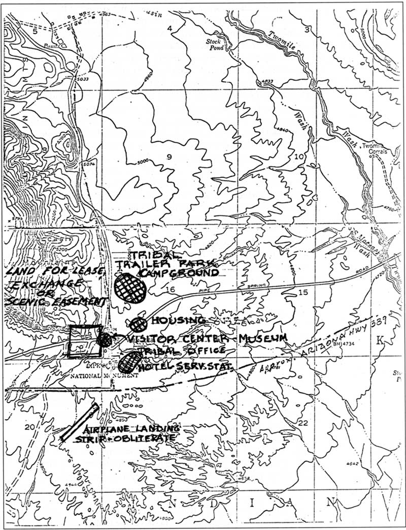
120. Sketch map of proposed locations of developments, April 1970
(Pipe Spring National Monument).
(click on image for an enlargement in a new window - ~177K)
On April 8 and 9, 1970, Gilbert, Davis, Schaack, Westley, and Wilson met at Pipe Spring with Geerdes and discussed the preliminary joint master plan, proposed land exchange, and joint-use visitor center. The group concluded there were three alternatives related to land acquisition: 1) the Park Service could press for a land exchange; 2) acquire other than fee title through a special use permit, scenic easement, or zoning of the desired buffer area; or 3) leave the land status as it was and encourage the Indians to manage the lands for recreational purposes. The recommendation was for the Park Service to push for the land exchange. With regard to the building and siting of what was then referred to as "the Tribal Visitor Center-Museum-Crafts Sales Building," three alternatives were considered: 1) the Tribe could build a facility on their land large enough for the Park Service to lease space for its visitor center and headquarters; 2) the Park Service could build on monument land (or on to-be-acquired or controlled "buffer zone" land) and grant space to the Tribe for concessions operations; and 3) a building could be constructed partly on NPS and partly on tribal land with each agency financing its portion. Since the proposed location for the visitor center was within lands proposed for future Park Service control (between the Moccasin Road and monument in the approximate area of the Indian pond), it was recommended at this meeting that the Park Service build the facility and provide space for the Tribe. The preliminary layout is shown in figure 120.
On April 30 and May 1, 1970, Ray Geerdes and Bill Tom traveled to Tuba City, Keams Canyon, Flagstaff, and the Grand Canyon on tribal and NYC program matters. The two men were unsuccessful in getting an NYC program established expressly for the Kaibab Paiute but they kept trying. Meanwhile, Geerdes found other ways to hire tribal youth through the NYC program. [2037]
At 11 a.m. on June 2, 1970, the Kaibab Paiute Tribe held an official dedication ceremony for the tribal office building, 10 new housing units in Kaibab, and the newly paved road to Kaibab and Moccasin. [2038] Both BIA and Park Service officials attended the event. Karl T. Gilbert, Ray Geerdes, and Volney Westley represented the Park Service. [2039] It is likely that addresses by either BIA or NPS officials that day included references to the mutual benefits expected to be derived from interagency cooperation. In his letter inviting Regional Director Kowski to the dedication, Superintendent Homer M. Gilliland, Hopi Agency, acknowledged the closer relationship: "The National Park Service, the Kaibab Tribe, and the Bureau of Indian Affairs are cooperating in various projects that will benefit all agencies involved. This total involvement will continue indefinitely and will provide social and economic benefits to the Indian and non-Indian communities." [2040] Indeed, by this date the agencies were working closely on a joint community master plan that involved the development of a joint-use water system and joint-use interpretive facility. Plans for a land exchange were also continuing.
On May 28, 1970, General Superintendent Gilbert made a formal request to Tribal Chairman Bill Tom for permission to drill a test well near Two Mile Wash, under the direction of USGS staff. Should an adequate well be developed on reservation land, Gilbert wrote in his memo, "we would propose entering into a formal and documented agreement regarding the use of the well. Provisions of this agreement would reflect Indian and Park Service needs based on final outcome of possible cooperative proposals." [2041] The Tribe passed Resolution K-2-70 in favor of granting permission to drill the test well on June 17 but as the resolution had to go through the BIA's Phoenix office for signatures, word was slow getting back to Gilbert. It was late July before he learned word-of-mouth that permission had been given. [2042] On August 12 Director William L. Bowen, Western Services Center, directed the chief of its Water Resources Division to take the necessary action to drill the test well. In late September Kowski made a formal request to Secretary of the Interior Walter J. Hickel that the Park Service proceed with drilling the test well(s). The objective was to locate a well capable of producing 75 gallons per minute of water. [2043]
By mid-June 1970, the Park Service had its joint development plan, maps, and layouts ready for field review as well as a draft Memorandum of Understanding (MOU) for operation and development for the Kaibab-Pipe Spring area. The Park Service had hoped to meet with BIA and tribal officials that month to go over the plan and MOU, but the earliest date convenient to all parties was July 20. On that date, a meeting was held at the new tribal office, attended by Park Service officials Karl T. Gilbert, Volney Westley, Dan Wilson, and Ray Geerdes; tribal officials Bill Tom and Ralph Castro; and BIA officials Al Purchase, Bob Orchard, and Homer G. Gilliland. Mutual concerns of water, land lease, or usage, and possible joint operation of a visitor center were discussed. [2044] Wilson and Orchard presented their respective proposed plans. [2045] In order that vistas south of the monument would remain unimpaired, the Park Service wanted there to be no developments along the main highway. The BIA plan called for all commercial development to be on the east side of the Moccasin road, with nothing located along the highway. Orchard's plan called for locating a picnic area west of the road, separate from the campground area, which was to be sited north of the tribal office. Geerdes argued for keeping the picnic area with the campground on the east side of the road. Others were in agreement. There was additional discussion about the campground, museum, and trailer park. Funds were immediately available to the Tribe to build a $6,500 trailer park. The Tribe's request for funds to build the motel had previously been turned down. The idea of a service station had also been dropped, but approved plans still were in place for additional housing and a $85,000 museum. Either BIA or tribal officials raised the question, would the Park Service be interested in leasing the Tribe's museum building as a visitor center? That was a possibility, Park Service officials responded.
Gilbert brought up the question of a land exchange at this July 20 meeting. Gilliland said he didn't think an exchange would be possible, but that land could be leased to the Park Service. [2046] Uncertain he could sell the Washington office on the idea of lease, Gilbert then asked about the possibility of a scenic easement. Discussion continued on the leasing idea. Gilliland and Tom were interested in knowing how joint plans might benefit the Tribe, particularly in the creation of new jobs. Tom was in favor of a snack bar and craft shop so that his people could continue to live and work on the reservation.
During the summer of 1970, in addition to its concern with the visual impact of tribal developments, the Park Service had concerns about a proposed transmission line south of Pipe Spring. Park Service officials were first notified about the Navajo Project's proposed line on May 13, too late to provide official comment at public meetings scheduled for May 5-7 in Las Vegas, St. George, and Kanab. Called the "Navajo-McCullough Transmission Line," it was to be located about four miles south of Pipe Spring, crossing the Arizona Strip from the Navajo Generating Station to the McCullough Switching Station. Park Service officials met with representatives of Los Angeles' Department of Water and Power on July 20 and expressed their objections to the damage to the historic and environmental scene, as visitors would view it from the monument. The intrusion of high tension lines and support towers cutting a swath across the scenic view was unacceptable, they maintained. Up to that time, Park Service officials argued, the panorama across the Arizona Strip was "practically unaltered" from the homesteading period of the late 1920s and 1930s. [2047] (Of course State Highway 389 was incongruous, but was acceptable because it brought visitors!) They suggested the company consider two alternate routes for its transmission line, one through the reservation and the other to the north, through BLM land. [2048] Company officials agreed to conduct a helicopter survey to determine if the Park Service's proposed alternate routes were feasible. Later, Gilbert was informed that the company's helicopter survey indicated that both routes proposed by the Park Service would work but that either route would be more costly than the route originally proposed. (See "The Navajo-McCullough Transmission Line" section, Part XI, for the outcome.)
| <<< Previous | <<< Contents >>> | Next >>> |
pisp/adhi/adhi10h.htm
Last Updated: 28-Aug-2006