|
PIPE SPRING
Cultures at a Crossroads: An Administrative History |

|
PART X - PIPE SPRING NATIONAL MONUMENT COMES ALIVE (continued)
Nature Trail
In mid-January 1964, Bob Olsen, Hugh Bozarth, and Joe Bolander scoped out possible courses for what was then called "a historic foot trail." Of course, as recounted in earlier chapters, this scoping exercise for a nature, geological, and/or historic walking trail had been performed from time to time for over three decades, but no funds were ever available to carry out plans. Olsen wrote,
A logical route is along the stone boat trail that runs along the face of the ridge west of the buildings, then up the ridge, and back to a point somewhere near the east cabin. There is about 400 feet of the stone boat trail, which is 2 to 3 feet high. It is first recognizable 225 feet west of the fort. [2055]
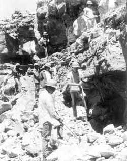 121. NYC boys working on the nature trail, July 1968. Boys include Russell and Clarence Tom, Larry Stephenson, Steve Tait, and "two Navajo" — possibly Johnnie Manymule, Keith Yazzie and/or Rex Tsi. Ray Geerdes is in uniform, leaning on a shovel. (Pipe Spring National Monument). |
The "stone boat trail" is also referred to in reports as the "quarry road" or "quarry trail." (Its historic use was described in Part I.) The proposed circle trail scoped out by the three men in January was given the name "Wamptun Trail." It terminated at the Powell survey monument. [2056]
On January 31, 1964, Olsen, Bozarth, and Bolander explored an area along the ridge just west of the monument boundary. Several large rocks with lines of cleavage cut in them and a large rock with three drill holes in it led the men to think that some of the rock used for the fort was quarried there. [2057] Several inscriptions were also located near this site. In March 1964 Olsen took Leonard Heaton about 500 feet west of the monument boundary to the site Bozarth discovered where there were a series of drill holes in the rock. Heaton told him the drill holes were of CCC vintage. In other words, this was the quarry site Camp DG-44 used for stone when it was needed for projects, such as to line the parking area with curbing. The CCC boys acquired quite a reputation for carving their names into historic buildings on the monument, so it is hardly surprising they also left inscriptions at their quarry site. A tentative sign plan was prepared for the nature trail in 1964. Though the trail had not been improved in any way, it appears that some visitors hiked it during the 1960s, just as Leonard Heaton had in the 1950s, at that time often accompanied by a group of boy scouts.
Nothing was done in the way of trail construction until 1968. In a cover letter for the monument's Environmental Study Area Inventory submitted to Zion in July 1968, Ray Geerdes pointed out the value of a combined historical/geological/nature trail:
Although the purpose of the trail is amply justified for interpretive purposes on a day by day basis it is ideally suited for an Environmental Education situation as it gives an excellent panorama overlooking the whole Arizona Strip country and an outstanding way to contrast the old overgrazed area with the native grass restoration projects. In addition it gives access to the Heart Canyon Petroglyphs and the Powell survey marker. [2058]
Zion officials were open to lending a hand, and Neighborhood Youth Corps enrollees afforded the monument additional labor. That May Geerdes began soliciting advice from trail foremen in area parks on building the combined history, geology, and nature trail. On July 8, 1968, Jim Schaack and Joe Davis came from Zion to inspect the proposed route for the new trail with Geerdes. On July 10 and 11 a trail crew from Zion blasted the overhangs for the trail route. A crew of NYC boys worked that month on building the trail, about one-half mile in length. Geerdes later estimated that the boys saved the Park Service $3,000 in construction costs. [2059] The first group to officially hike the newly created trail (still without signage) was a group of 30 4H girls from Fredonia on July 30. As mentioned earlier, Geerdes received permission from Tribal Chairman Vernon Jake to add a gate and way trail to connect the nature trail to the Heart Canyon petroglyph area and Powell monument. Former Custodian Leonard Heaton's recommendation for a trail, first made to Southwestern National Monuments' Superintendent Frank Pinkley in January 1934, had finally been realized.
In October 1968 the Zion Natural History Association purchased metalphoto materials for the monument to develop interpretive signage along the self-guided trail. In November 1968 Zion staff assisted Allen Malmquist with the construction of 14 metalphoto-routed interpretive signs, which were erected the same month along the trail. By July 18, 1969, Geerdes estimated over 3,000 people had used the new trail. [2060]
| <<< Previous | <<< Contents >>> | Next >>> |
pisp/adhi/adhi10j.htm
Last Updated: 28-Aug-2006