|
Golden Spike
Cultural Landscape Report |

|
CHAPTER 3:
EXISTING CONDITIONS
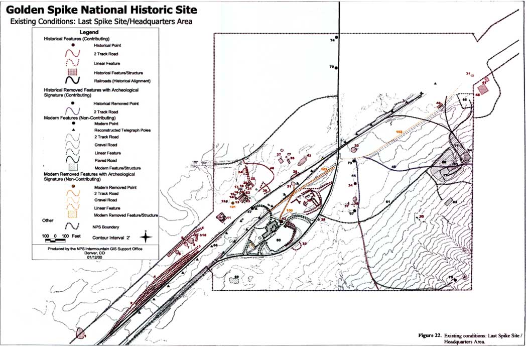
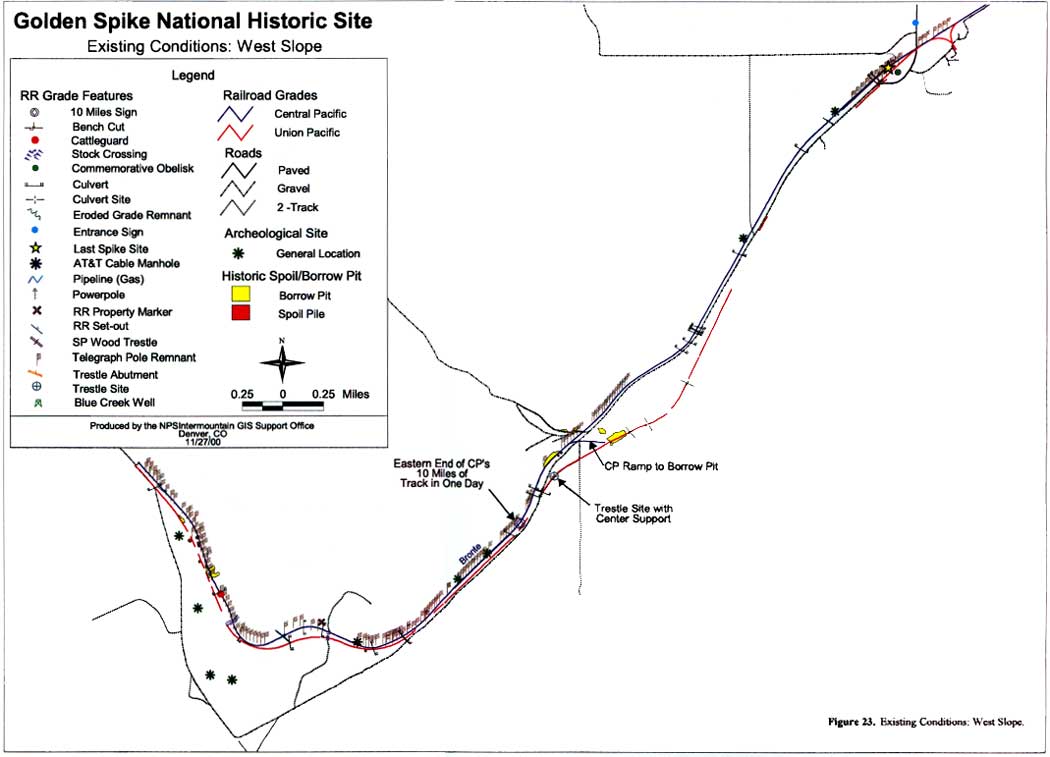
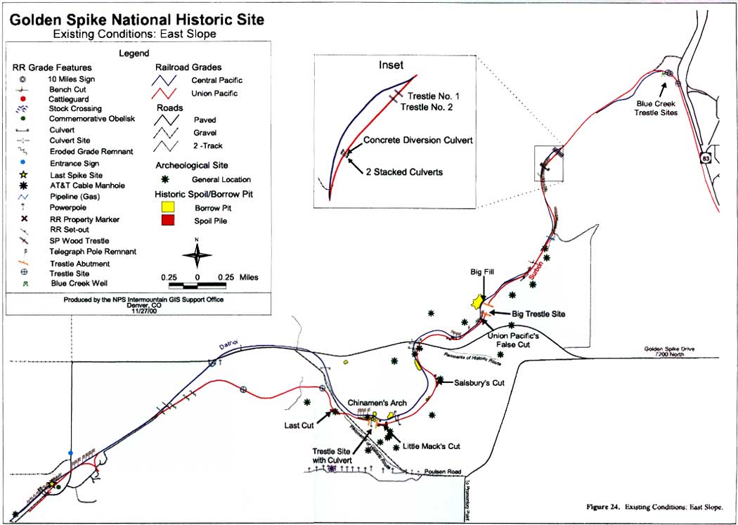
The Golden Spike National Historic Site is comprised of three distinct areas, Promontory Summit or the "headquarters" area, which includes the "Last Spike Site," and the two predominately linear segments of park land that extend east and west from the site, referred to as the West Slope and the East Slope. Promontory Summit serves as the center for visitor services and interpretation and for park service administration, and maintenance. Areas to the east and west sides of the Last Spike Site are used principally for interpretive purposes. The following discussion of the existing conditions of Golden Spike NHS is organized by landscape characteristics, in most cases with a separate discussion for each of the three areas identified above. Figures 22 through 24 illustrate the existing conditions of the summit and of the west and east slopes respectively.
|
| Figure 22. Existing conditions: Last Spike Site/Headquarters Area. (click on image for an enlargement in a new window) |
Figure 22. Key
| Feature Number |
Description and Identification (If Known) |
|---|---|
| Historic Features (contributing to landscape significance) | |
| 1 | Historic trash area — Possibly the remains of the Peterson Ranch |
| 2,3,4 | Railroad track beds |
| 5 | Historic trash area |
| 6 | Abandoned road or road-like feature |
| 7,8 | Historic trash area |
| 9 | Depression & historic trash area |
| 10 | Cellar & small pit |
| 11 | Matrimony Vine (Lycium barbarum) cluster with scattered bricks on the surface. This may be the remains of the Section House. |
| 12,13,14 | Depressions |
| 15 | Historic trash area |
| 16 | Shallow depression |
| 17,18,19 | Depressions |
| 20 | Shallow depression |
| 21,22 | Small circular pits |
| 23 | Matrimony Vine (Lycium barbarum) cluster with shallow depression in the center. This may be the remains of the "tie houses" — the Southern Pacific houses for workers. |
| 24 | Site of Promontory school house (second and third school houses) |
| 25 | Abandoned path or feature resulting from ground disturbing removal of the 3rd schoolhouse. |
| 26,27 | Site of ranch buildings, cistern (Floyd/Larson Place) |
| 29* | Mound of cinders |
| 30 | Site of Houghton Store & associated structures — now appears as Matrimony Vine (Lycium barbarum) clusters, cistern & cellar |
| 31 | Historic box elder (Acer negundo) trees |
| 32 | Site of "Blue House." This is the remains of the wind mill foundation and location of the well. Semicircular berm around well is recent and done to protect the well from water runoff. Blue house site is actually under the road, and associated Matrimony Vine appears north, around the modern parking lot. This was the Houghton home. |
| 33 | Large circular depression once used for feeding cattle. Its original function is unknown. |
| 34 | Hansen cistern |
| 35 | Building debris |
| 36 | Hansen Ranch remains and features |
| 37 | Depression — Hansen Ranch remains |
| 38 | Golden Currant (Ribes aureum) |
| 39 | Round house foundations (based upon LeFevre's 1973 test excavations) |
| 40 | General site of post — 1910 burial (railroad worker) — site located in 1978 by Mayme Lower, whose family tended the grave as long as she lived in Promontory Station. |
| 41 | The third Promontory school house. (Private ownership; not in original location — moved when NPS acquired lands.) |
| 42 | General site of 5 historic graves once tended by Whitaker family before locations were obliterated by NPS — area pointed out by Arnold Whitaker in 2000. |
| 43 | Current location of Commemorative Obelisk (moved to this site in 1980) |
| 44, 45 | Abandoned ranch roads |
| 46 | NPS two-track service road on alignment of historic road system through Promontory Station |
| 47 | Original location of Commemorative Obelisk |
| 48 | Snodgrass complex, including windmill, matrimony vine clusters, building remains |
| Modern Features (non-contributing to landscape significance) | |
| 60 | Visitor center/administrative offices/interpretive complex/parking |
| 61 | Service road to residence and maintenance facilities |
| 62 | Ranger residence |
| 63 | Maintenance facility |
| 64 | Engine house |
| 65 | NPS "bone yard" storage facility |
| 66 | Reconstructed telegraph poles |
| 67 | NPS well |
| 68 | NPS earthen protective screen (berm) for maintenance yard |
| 69 | NPS septic system |
| 70 | NPS entrance sign |
| 71 | Engine yard |
| 72 | Maintenance yard |
| 73 | NPS fire hydrant |
| 74 | Transformer |
| 75 | NPS water tank |
| Modern Removed Features (non contributing to landscape significance) | |
| 100 | Remains of NPS gravel path to now-removed picnic area underneath Box Elder tree. |
| 101 | Second location of Commemorative Obelisk — Moved to this site in 1968 and moved to current location in 1980. |
| 102 | Abandoned county road |
| 103 | 1969 NPS erroneous reconstruction of UP siding |
|
| Figure 23. Existing Conditions: West Slope. (click on image for an enlargement in a new window) |
|
| Figure 24. Existing Conditions: East Slope. (click on image for an enlargement in a new window) |
| <<< Previous | <<< Contents >>> | Next >>> |
http://www.nps.gov/gosp/clr/clr3.htm
Last Updated: 27-Jul-2003