|
Golden Spike
Cultural Landscape Report |

|
CHAPTER 3:
EXISTING CONDITIONS (continued)
Existing Land Use and Spatial Organization
Promontory Summit
Promontory Summit is the most intensively developed area within the park boundaries. It serves as the focal point for park service interpretive and commemorative efforts, for visitor services, and for park service administration and maintenance. The single, permanent employee housing unit is also located in this area.
Interpretation and Commemoration
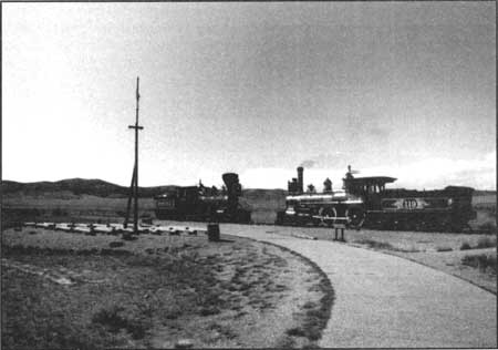
Park visitors are usually introduced to the site through the visitor center, where they pay their entrance fees and are given the opportunity to watch a film or video and view the museum exhibits. Visitors then proceed outside to the Last Spike Site. In order to present the events of May 10, 1869, the park service has reconstructed the transcontinental grade tracks and ties along its historical alignment. Replicas of the two telegraph lines, square poles for the CP and round poles for the UP have also been reestablished along the two respective grades. A United States 20-star flag flies from a pole affixed to one of the UP telegraph poles. Two full-scale operational steam engines, replicas of the UP's 119 and the CP's Jupiter, are used daily during the summer season to reenact the joining of the rails. Wooden benches have been constructed just opposite the Last Spike Site, to accommodate visitors during the park's reenactment of the ceremony. Modern interpretive signage is also located in the vicinity of the visitor center and the Last Spike Site. Figure 25 shows the reconstructed rails and replica engines at the Last Spike Site.
|
| Figure 25. View to northwest toward the reconstructed rails and replica engines at the Last Spike Site. Source: HRA 2000. |
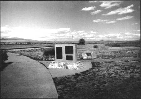
An area near the visitor center contains various memorial plaques, erected to commemorate the contribution of various ethnic groups (Chinese, Irish), to the completion of the nation's first transcontinental rail line (Figure 26). The obelisk erected by the Southern Pacific Railroad to commemorate the completion of the transcontinental line is currently located on the east side of the visitor center, opposite the parking area.
|
| Figure 26. View to northeast—memorial plaques at rear of Visitor Center. Source: HRA 2000. |
Visitor Services
Visitor services other than those associated with interpretation are limited. Restroom facilities are contained within the visitor center, and a few picnic tables are located outside this building.
Park Service Administration and Maintenance
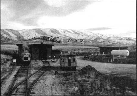
Park administration functions are housed in the visitor center. Maintenance buildings (consisting of a combination garage/shop and the engine house) are located about 1000 feet northeast of the visitor center at the base of a hill slope (Figure 27). A large earthen berm shields these buildings from the visitor center and Last Spike Site. A "bone yard" consisting of three small buildings and piles of surplus materials, is located 150 north of the primary maintenance area, adjacent to the park boundary (Figure 28).
|
| Figure 27. View to southeast towards the engine house. Roof of maintenance building is visible at right of photo. Source: HRA 2000. |

|
| Figure 28. View to northwest toward park service bone yard. Promontory school and windmill. Fence marks the current park boundary. Source: HRA 2000. |
Employee Housing
The single permanent housing unit, the ranger residence, is located in the vicinity of the maintenance area, northeast of the visitor center. Within the past year several trailers have been moved into the area adjacent to the visitor center for use as housing for a seasonal archaeological field crew. Concrete pads for volunteer trailers and motor homes are also located adjacent to the visitor center.
West Slope
Interpretation and Commemoration
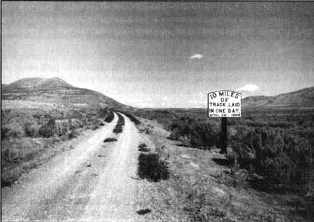
Lands within the park boundary west of Promontory Summit are used principally for interpretation of the final push to complete the transcontinental railroad. Portions of the transcontinental railroad grade (the grade originally constructed by the CP) have been adapted for reuse as a self-guided automobile tour route. Numbered stops along the grade correspond to a tour book obtained at the visitor center. In addition to the continuous segment of the CP grade, this area contains the discontinuous segments of the UP grade, which was never completed. A replica of the historic-period sign marking the completion point of the CP's 10 miles of track laid in a day is the single commemorative marker in this area (Figure 29).
|
| Figure 29. View to northeast along CP grade — west auto tour — replica of historic "10 miles of track laid in one day" sign. Source: HRA 2000. |
Agricultural uses
Other west slope land uses include two stock crossings. Adjacent private landowners move their livestock from one side of the grade to another through the specified crossings demarcated by an electric fence. Land use adjacent to the grade but outside the park boundary is limited to agricultural activities including grazing and some dry-land farming.
East Slope
Interpretation and Commemoration
Like the lands on the west slope, lands within park boundaries on the east slope are also used primarily for interpretive purposes. The East Grade Auto tour runs along a portion of the historic transcontinental grade in this East Slope area. In addition to the auto tour, there is also an interpretive hiking/biking trail — the Big Fill Walk — that interprets the construction challenges of the Big Fill built by the Central Pacific and the Big Trestle built by the Union Pacific. The park service has added several parking pullouts, some with interpretive signage, to access points of interest.
Agricultural Uses
Like the west slope, the east slope park lands also are affected by adjacent agricultural uses. Along this portion of the grade there are several ranch access roads that cross the grade. At the east end of the park, near Blue Creek, the railroad grade was once used as a county access road. Local ranchers continue to use it in this manner.
| <<< Previous | <<< Contents >>> | Next >>> |
http://www.nps.gov/gosp/clr/clr3a.htm
Last Updated: 27-Jul-2003