|
Golden Spike
Cultural Landscape Report |

|
CHAPTER 3:
EXISTING CONDITIONS (continued)
Circulation
Circulation systems within the park consist of the publicly funded road systems that provide access to and through the park, private ranch access roads, internal roads constructed by the park service primarily for operations and maintenance purposes, and park service interpretive roads and trails. In addition, the summit area contains a variety of pedestrian paths to facilitate movement through the visitor center and Last Spike Site.
Promontory Summit
Public Access
The only access route into the park is via County Road 7200 North, also known as Golden Spike Drive. This road branches from State Highway 83 and leads to the park service visitor center at Promontory Summit where it skirts the perimeter of the parking lot (Figure 30). Access into and out of the parking area is limited to two points by a continuous curb. Visitors enter the parking area through an opening in its east side and exit through an opening at the west end. Visitors can either proceed west along the county road to access the starting point of the west-side auto tour, or turn back east to exit the park along the same route that they came in.
|
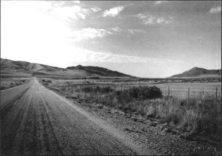
| Figure 30. View to southwest towards Last Spike Site and Visitor Center from county access road. Source: HRA 2000. |
Pedestrian Paths
The pedestrian circulation system in the vicinity of the visitor center begins in the parking lot, where an exposed aggregate sidewalk leads to the entrance to the building. Visitors proceed to the Last Spike Site through a doorway at the rear of the visitor center, where they follow a circular path (also constructed of exposed aggregate) to the "Last Spike Site."
Internal vehicular circulation
The visitor center/administration area is connected to the maintenance area/boneyard and the ranger's residence by a narrow gravel roadway constructed by the park service. Public access to this road is restricted by signage.
West Slope
Public Access
West of the visitor center the county road parallels the abandoned grade of the transcontinental railroad. Just past the visitor center parking lot the surface changes to gravel. The road extends southwest paralleling the old railroad grade past the west end of the NHS and the access point for the west side auto tour. Approximately 4.5 miles of the county road are located within the NHS boundary.
Interpretive Roads and Trails
The park's west-side auto tour, 4 miles in length, is located on top of the grade constructed by the Central Pacific. (The west-side auto tour will be extended to 7 miles in length as soon as a stave culvert is reconstructed.) The access point for this tour is located on a Bureau of Land Management parcel west of the west NHS boundary. Cars may travel eastward only along the top of the old railroad grade. Tracks and ties have all been removed; gravel has been added to the surface of the grade to protect it from erosion.
East Slope
Public Access
Public access roads on the east slope include Golden Spike Drive (7200 North), and Poulsen Road (see Figure 24). Both roads bisect the large block of park service land on the east slope. Golden Spike Drive is a paved two-lane road; Poulsen road has a gravel surface.
Interpretive Roads and Trails
The east slope auto tour is approximately 2.5 miles in length. The east auto tour is accessed directly from Golden Spike Drive. This also is a one-way route located on top of the CP grade with a gravel surface. The only modification to the grade to accommodate this adaptive reuse has been the application of gravel to the grade surface. A short access trail has been constructed from a parking pull-off along the east-slope auto tour to provide access to an overlook above the UP's "Last Cut." This is a stone-lined graveled path through sagebrush scrub that crosses Poulsen Road to a point overlooking the Last Cut.
In addition to the auto tour, a 1-1/2 mile hiking and biking trail, the "Big Fill Trail" follows the route of the historic parallel grades for the Union Pacific and the Central Pacific Railroads up to the Big Fill and Big Trestle site. This section of abandoned grade was formerly part of the east slope auto tour. A short connecting trail between the west edge of the Big Fill and Big Trestle provides access between the two grades and a vantage point that also contains an interpretive sign.
Private Ranch Access
Several ranch access roads that predate the establishment of the park continue to be used by local ranchers to access private property truncated by the old railroad right-of-way (Figure 31). These are principally unimproved dirt two-tracks.
|
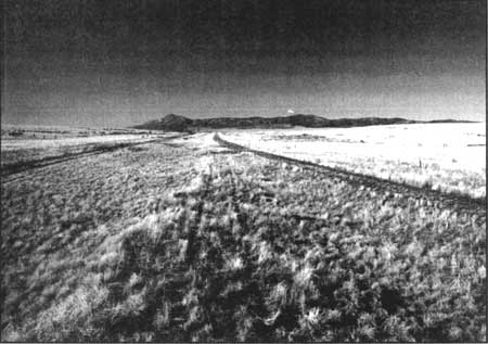
| Figure 31. View to west along CP constructed grade in the summit area. Two-track access road to left of grade provides ranch access for private landowner. Source: HRA 2000. |
| <<< Previous | <<< Contents >>> | Next >>> |
http://www.nps.gov/gosp/clr/clr3b.htm
Last Updated: 27-Jul-2003