|
CUMBERLAND ISLAND
An Ecological Survey of the Coastal Region of Georgia NPS Scientific Monograph No. 3 |

|
CHAPTER 2:
The Regional Setting
Geology
The mainland rivers that flow into the Atlantic Ocean along the Georgia coast drain three major physiographic provinces: the Blue Ridge Mountains, the Piedmont Plateau, and the Atlantic Coastal Plain (Fig. 2). The geology of these provinces greatly influences the amount and characteristics of surface water, groundwater, and sediments transported to the marshes, estuaries, and continental shelf.

|
| Fig. 2. Mainland river systems discharging into the estuaries of Georgia. |
Soils of the Blue Ridge and Piedmont provinces are derived from crystalline rocks dating to pre-Cambrian time. The two major river systems of the Atlantic drainage in Georgia have their origins in these provinces. The headwaters of the Savannah River are in the Blue Ridge province and the Altamaha River originates in the Piedmont.
The lower (southern and eastern) edge of the Piedmont is marked by the Fall Line, an old shoreline formed by the greatest advance of the sea late in the Mesozoic Era. The Coastal Plain is overlaid by many sedimentary strata tilted toward the sea. These deposits were formed during the many changes in sea level associated with glaciation during the Tertiary and Quaternary periods. The thickest deposits are in the coastal area (about 6000 ft at Savannah), tapering to a thin edge at the Fall Line, where the oldest (Cretaceous) sediments are exposed. Progressively more recent strata occur at the surface toward the coast, and relict coastal features, such as barrier islands and lagoons, are still evident in many places.
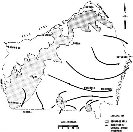
Limestones of Tertiary and Quaternary age underlying the Coastal Plain form one of the most productive aquifer systems in the country. The Tertiary limestone is several thousand feet thick, ranging in age from Paleocene to Pliocene. The hydrologic unit of this limestone, deposited in the period from mid-Eocene to mid-Miocene, is the principal artesian or Coastal Plain aquifer, which is recharged with water where it is exposed near the Fall Line (Fig. 3). It slopes gently to the coast and appears on the continental slope as freshwater springs in the ocean.
|
| Fig. 3. Recharge area of the principal artesian aquifer and direction of groundwater movement. (Redrawn from Callahan 1959, 1964.) |
The region is generally one of low seismic activity. However, a major earthquake, having its epicenter at Charleston, S.C., occurred in 1886. This earthquake, registering 10 on the Richter scale, caused 150 human deaths and damaged buildings in the Savannah area.
Climate
The coastal region of Georgia has a relatively moderate climate. Average temperatures of the islands are slightly lower than on the mainland. Sea breezes offer relief from intense summer heat. Daily maximum temperatures in July and August (the warmest months) are usually in the 80s and low 90s. The islands are the only part of the state south of Atlanta that has mean daily maximum temperatures below 90°F in July and August (Carter 1967).
Winters are relatively mild and short. The average minimum temperature for December and January (the coldest months) is about 43°F. On the average, there are 305 freeze-free days at Brunswick and 267 at Savannah (Carter 1970b).
Average temperatures for four coastal stations are shown in Table 1.
The coastal islands have an average annual rainfall of about 53 inches. Average monthly precipitation is presented in Table 2. Rain is most abundant in the summer and early fall, with half of the annual precipitation occurring between June and September. The driest period is November through February (Carter 1967). Most precipitation in late fall and winter is of the frontal type, but most rain in the spring and summer comes as afternoon thundershowers (convectional precipitation). Heavy rainfall in September commonly is associated with hurricane conditions.
The first recorded hurricane to cause significant damage to the Georgia coast struck the Charleston, S.C., area on 15 September 1752 (Carter 1970a). Since that time, numerous hurricanes have passed along the Georgia coast, but surprisingly few have caused serious damage. Between 1886 and 1968, 669 tropical cyclones, developed in the Atlantic, the Caribbean, and the Gulf of Mexico. Of these, 93 passed into Georgia, or passed so near that they had an appreciable effect on the state's weather. Only 56 of these reached hurricane magnitude, and just eight carried hurricane winds into the state. Therefore, the frequency of true hurricanes on the Georgia coast averages one per 10 years. Less intense storms may cause major damage more frequently (Carter 1970a).
Hurricanes off the east coast tend to follow the path of warm, lighter air above the Gulf Stream, which is flanked on both sides with heavier, cooler air. Brunswick, Ga., is farther (80 miles) from the Gulf Stream and the accompanying warm air than any other place on the southeastern coast. Consequently, the Georgia coastal area is less exposed to hurricanes than areas farther north or south (Gibson 1948).
All hurricanes that have affected Georgia between 1886 and 1968 have occurred between August and October (Carter 1970a).
History
By various estimates, man has inhabited the North American continent for 10,000-40,000 years. There is increasing evidence that human occupancy of what is now the coastal region of the southeastern United States extends at least 10,000 years into the past. This is difficult to prove because archaeological evidence in coastal areas is quickly destroyed by changing sea levels with constant erosion and deposition so that many early sites are probably located under the water on the continental shelf and visible traces of human occupation date back only about 4000 years. Sites on the barrier islands dating from A.D. 500 to 1300 reveal that the inhabitants cultivated corn, beans, pumpkins, and other crops before contact with Europeans. Shell heaps and middens attest to the importance of shellfish in the diet of the original inhabitants.
TABLE 1. Normal temperatures for four locations on the coast of Georgia. a
| Month | Location and Temperature | |||
| Savannah | Blackbeard Is. | Brunswick | St. Simons Is. | |
| January | 51°F | 53°F | 55°F | 52°F |
| February | 53 | 54 | 57 | 55 |
| March | 59 | 58 | 62 | 60 |
| April | 66 | 67 | 68 | 67 |
| May | 73 | 74 | 76 | 74 |
| June | 79 | 80 | 81 | 80 |
| July | 81 | 82 | 82 | 81 |
| August | 81 | 82 | 82 | 81 |
| September | 76 | 78 | 79 | 78 |
| October | 67 | 69 | 71 | 69 |
| November | 58 | 59 | 62 | 60 |
| December | 51 | 52 | 55 | 53 |
| Annual | 66 | 67 | 69 | 67 |
aData from Carter 1967, 1970b and U.S. Fish and Wildlife Service 1962. | ||||
TABLE 2. Average rainfall at four locations on the coast of Georgia.a
| Month | Location and Rainfall (inches) | |||
| Savannah | Blackbeard Is. | Brunswick | St. Simons Is. | |
| January | 2.8 | 2.1 | 2.3 | 2.5 |
| February | 3.7 | 3.6 | 3.0 | 3.1 |
| March | 4.0 | 3.5 | 3.8 | 3.8 |
| April | 3.7 | 3.3 | 3.2 | 3.4 |
| May | 3.8 | 3.4 | 3.6 | 3.1 |
| June | 5.1 | 3.9 | 5.5 | 5.6 |
| July | 6.6 | 5.6 | 7.3 | 5.9 |
| August | 6.6 | 4.4 | 7.0 | 5.3 |
| September | 5.3 | 9.7 | 9.1 | 10.3 |
| October | 2.6 | 4.3 | 4.5 | 4.8 |
| November | 2.1 | 1.9 | 1.5 | 2.2 |
| December | 2.8 | 1.9 | 2.6 | 2.5 |
| Annual | 48.9 | 47.6 | 53.3 | 52.6 |
aData from Carter 1959, 1967 and U.S. Fish and Wildlife Service 1962. | ||||
Archaeologists from the University of Georgia are conducting intensive excavations on St. Catherines Island. These studies, not yet published, should greatly increase our understanding of the aboriginal inhabitants of the islands. Results of previous archaeological studies in the area are summarized by Caldwell (1952), Williams (1967), and Fairbanks (1968).
European influence began in 1568 with the establishment of the first Spanish missions. Although periodically destroyed or otherwise interrupted, these missions tenaciously clung to survival for over one hundred years. During their tenure, the Spaniards enriched the native fare by the introduction of exotic plants (figs, oranges, other fruits) and domesticated animals (hogs, goats).
In 1685 the English and their native allies invaded from the north and destroyed the missions and the island natives. For about 50 years the islands remained uninhabited and, except for occasional visits by pirates and Indians, undisturbed.
In 1732 George I granted the region to General James Oglethorpe as a buffer against the Spanish in Florida. Oglethorpe landed in Savannah in 1733, and his efforts toward colonization extended south to St. Simons where he built Fort Frederica and ended the Spanish threat in North America.
By 1776 Savannah, Richmond Hill, Midway, Sunbury, Darien, Brunswick, and St. Marys were thriving agricultural communities. Naval stores (tar, pitch, turpentine) and live oak timbers were the earliest major economic resources of the islands, which soon came under intensive agriculture. On the mainland as well as the islands the colonists experimented with a variety of subtropical plants including olives, dates, oranges, figs, rice, indigo, hemp, pomegranates, coffee, tea, and silk. The climate proved unsuitable for oranges, although they persisted as a minor crop for many years. Silk was a major crop for a few years and was produced on a minor scale as late as 1790. By 1750 rice and indigo were well established as profitable crops. The Revolutionary War brought about a decline in the market for indigo, which was largely supplanted by rice except on the islands (Bonner 1964).
Rice was grown in diked fields at the mouths of mainland rivers. Production reached its peak between 1850 and 1860. Chatham County was the leading producer, followed by Camden, McIntosh, Glynn, Liberty, and Bryan counties (Long 1958). In 1859 planters were harvesting an average of 50 bushels per acre, with about 23,000 acres in cultivation. Total state production was 52,507,652 lb (Long 1958).
Long-staple cotton, imported from the Bahamas about 1785, was first grown on St. Simons and was soon cultivated on the other islands and the adjacent mainland along the Georgia and South Carolina coasts. This variety known as sea island cotton, far superior to upland cotton, sold for two to five times the price of the latter.
The plantation era on the Georgia coast was marked by a sophisticated level of land management. Despite malaria and yellow fever, which drove the white planters and their families inland during the growing season, the planters cleared thousands of acres of forest and cypress swamp to grow rice and other crops. Plantation owners were well educated and included some of the most advanced agriculturists in the nation, employing practices generally attributed to a much later age. These included irrigation, drainage, liming, fertilization, crop rotation, fallowing, composting, mulching, and biological insect control (using flocks of turkeys to control leaf worm caterpillars in cotton). Of particular interest was the application of marsh mud, crushed oyster shell, cordgrass, and stable manure to the fields. The application of marsh mud to the fields was considered essential to successful crop production. These agronomic practices and the social life on the sea island plantations are discussed in detail by Johnson (1930).
The war for southern independence and the ensuing abolition of slavery marked the beginning of the end for the plantations and for prosperity and a way of life. Survivors of the war returned to their devastated lands and attempted to restore the plantation system with paid labor, but the freed slaves and imported Irish and Chinese laborers proved to be undependable sources of labor and the plantations were soon abandoned.
Thus, within a few years, the coastal area changed from one of the most prosperous regions in the nation to one of the poorest.
Most of the islands were more or less deserted until the 1890s when wealthy industrialists purchased them and restored some of the remaining plantations. Except for Blackbeard, which was in public ownership, and Tybee, Sea Island, and St. Simons, which became residential areas, the islands remained private, relatively natural, well-managed retreats.
The fascinating history of the sea islands has been a favorite topic of writers. For further information on the subject see Johnson (1930), Lovell (1932), Vanstory (1956), and Fancher (1971).
Economics
The settlement and development of the Georgia coast was dependent upon agriculture. Lack of a satisfactory substitute for plantation agriculture, after its destruction, resulted in a long period of economic depression still evident in many parts of the region. This has been responsible for the relatively slow rate of population growth (Table 3). The cities of Savannah and Brunswick have accounted for most population growth and the population of the coastal counties has become urbanized at an increasing rate. Sudden bursts of growth in population have occurred locally in the rural counties as a result of the establishment of new industries or, in the case of Liberty County, a military installation.
Vital statistics and socioeconomic data for the coastal counties during the period 1950-70 are summarized by Clement (1971) and Pinson and Weldon (1964) for Bryan, Camden, Glynn, Liberty, and McIntosh counties; by Sanders (1968) for Chatham County; and by Keeling et al. (1968) for Camden and Glynn counties. Carley (1968) presented economic data concerning the commercial fisheries industry.
Commercial fishing and forestry have been the most important economic activities of this century. The fisheries and forest resources support an increasing number of industries engaged in processing, manufacturing, and marketing sea foods and wood products. The pulp and paper industry has expanded, however, at the expense of the fishing industry, which has suffered greatly from pollution caused by the paper mills.
TABLE 3. Population trends for the coastal counties of Georgia: 1790-1970.a
| Year | County and Population | |||||
| Chatham | Bryan | Liberty | McIntosh | Glynn | Camden | |
| 1790 | 10,769 | - | 5,355 | - | 413 | 305 |
| 1832 | 14,127 | - | 7,233 | 4,998 | 4,567 | 4,578 |
| 1860 | 31,043 | 4,015 | 8,390 | 5,546 | 3,889 | 5,420 |
| 1890 | 57,740 | 5,520 | 12,887 | 6,470 | 13,420 | 6,178 |
| 1930 | 105,431 | 5,952 | 8,153 | 5,763 | 19,400 | 6,338 |
| 1940 | 117,970 | 6,288 | 8,595 | 5,292 | 21,920 | 5,910 |
| 1950 | 151,481 | 5,965 | 8,444 | 6,008 | 29,046 | 7,322 |
| 1960 | 188,299 | 6,226 | 14,487 | 6,364 | 41,954 | 9,975 |
| 1970 | 182,912 | 6,116 | 17,156 | 6,938 | 48,474 | 10,815 |
aUS. Census data from reports of the Bureau of Census, U.S. Department of Commerce. | ||||||
The Coastal Plain of Georgia and the Carolinas generally is regarded as an economically depressed region and efforts are being made at the local, state, and national levels to improve economic conditions in the area. But, ironically, economic growth often produces undesirable impacts on the local environment and culture; the low level of economic growth has kept the level of environmental degradation relatively low. Consequently, the people of this region still have options open to them as to future development that are not available to those in other areas.
| <<< Previous | <<< Contents >>> | Next >>> |
chap2.htm
Last Updated: 1-Apr-2005