|
CAPE LOOKOUT
Barrier Island Ecology of Cape Lookout National Seashore and Vicinity, North Carolina NPS Scientific Monograph No. 9 |

|
CHAPTER 3:
OVERWASH STUDIES AT CAPE LOOKOUT NATIONAL SEASHORE (continued)
GENERAL ZONATION PATTERNS (continued)
II. Maritime grasslands:
Down the center of the Outer Banks run terrestrial grasslands of four basic types: barrier flats, dune strand, dune slacks, and mesic meadows. These grasslands combined occupy most of the supratidal land surface, and all four types intergrade with each other. The barrier flats are the extensive overwash terraces that characterize these banks, with dunes having formed on the terraces. However, where the islands are oriented across prevailing winds, the dune strand community predominates. Dune slacks are depressions between dunes, frequently formed by blow outs, the sand being removed down to the water table. Here, relatively mesic conditions and rich flora can be found. In contrast to the inter-dune slacks, yet similar in their mesic environment, are the low, flat, relatively rich meadows below the elevation of typical barrier flat communities, which are neither fresh-water marshes nor tidal flats. In general, these grasslands are maintained by environmental stress imposed by the oceanic environment: salt spray, overwash flooding and burial, moving sand, and ground water. Where such conditions are ameliorated by some means, the grasslands may succeed to woody vegetation.
a. Barrier flat grassland:
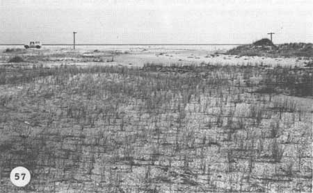
This vegetation type might be called an "overwash subclimax" because it is controlled by oceanic overwash. It is the predominant community on the flat, extensive overwash terraces that are typical of the low barrier islands. The grassland begins on the backslope of the berm, usually between the low open dunes, or even in front of dunes, and covers the flats behind the dunes. The general appearance of this community is not unlike that of a Midwest prairie, stretching off as far as the eye can see. On many sections of the barrier islands, this flat grassland appears to be the only vegetation except for that of the low dunes and salt marshes. Its development and maintenance are controlled by salt spray, and more importantly, by overwash; the land is low enough to be flooded frequently and buried, so that plants here have a harder life than do those that grow on dunes. The overwash community begins on the back side of the berm, where a balance between wave action and deposition and plant colonization seems to be reached (Fig. 57). Storm waters regularly sweep down the berm slope and inundate this community, as evidenced by numerous drift lines in the grassland. The vegetation is well adapted to overwash burial and the rolling-over process by which the barrier islands retreat. As long as overwash operates, the ecosystem will persist for long periods; in this sense it can be considered an "overwash subclimax." The maritime barrier flat grassland is best developed on overwash terraces which grade together to form a flat surface. Dune strand vegetation can develop on these terraces as well, but only where enough sand has accumulated to raise the strand above the flooding level. Thus, the elevation of this community is set by the most severe storms of each storm cycle.
|
| Fig. 57. Open Spartina patens grassland on Core Banks at Profile 14, looking toward the ocean. The grassland has formed on an overwash pass and recent overwash deposits. Dark patches in the pass are driftlines from storm tides. |
The barrier flat vegetation consists primarily of grasses, sedges, and a few forbs. Figure 48 shows a generalized cross section across a barrier island, with overwash-dependent zonation. Toward the berm, where flooding and burial are most frequent, is a generally open grassland dominated by Spartina patens, growing in scattered tussocks, with a low standing crop (generally less than 50 g/m2 dry weight) and low cover (less than 20%). The vegetation becomes increasingly sparse approaching the berm slope. This is the zone where the ability of the grass to grow seaward and the regular overwash waves that keep the grass back are in conflict. During periods of relatively few storms, the vegetation migrates seaward only to be knocked back during storms. The open grassland grows on the most recent terraces, which are created or modified by regular storms. Growing with Spartina are scattered annuals, of which Euphorbia polygonifolia and Cakile edentula are the most common. Back from the berm zone, and in between the dunes, where overwash is less severe, the vegetation increases in complexity and biomass (Fig. 58). The Spartina is denser and is joined by Solidago sempervirens (seaside goldenrod) as a co-dominant. The major species of this vegetation type are resistant to salt spray (Oosting 1954) and salt water flooding (Seneca 1969). The fact that they exist in zones here supports the thesis that such zones are more a function of overwash than of spray.

|
| Fig. 58. The most recent overwash fan on Transect #1 at Codds Creek. This is the major terrestrial vegetation zone on these islands: broad grassy flats extending up and down the interior between dunes and marshes, open in the foreground, more closed in the distance. Solidago sempervirens and Muhlenbergia capillaris are seen with the dominant Spartina patens. The boards come in with overwash water. |
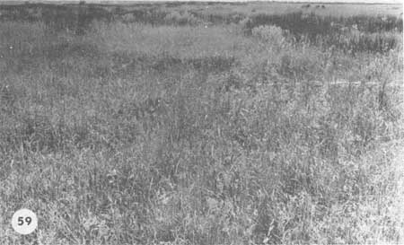
The open grassland extends back across the more recent overwash surfaces to the point where the elevation breaks and drops slightly to the next terrace, deposited during the severe storms of the late 1950s and early 1960s; thus they are older terraces. A new, severe storm could overwash all of the existing terraces and create a new surface well back on the older layers. On these lower and older terraces the salt content is low, and the water table is near the surface. Here the open grassland grades into a closed community, with more than 50% cover and a standing crop of up to 1500 g/m2. Spartina patens, Solidago sempervirens, Eragrostis pilosa (love-grass), Fimbristylis spadicea, Muhlenbergia capillaris (hairgrass), Cynodon dactylon (Bermuda grass), Cenchrus tribuloides (sand-spur), Chloris petraea (finger grass), Gaillardia, Pluchea, Sabatia stellaris (sea-pink), Cynanchum palustre (climbing milkweed), Ipomea sagittata (morning glory), Spiranthes vernalis (nodding ladies tresses) and other species share dominance (Fig. 59). The high standing crop and species diversity indicate that this is the most benign of the flat terrain habitats that are still subject to occasional sea-water flooding. Species from both the maritime grasslands and the high salt marsh mix in these closed grasslands. If the frequency of overwash and flooding decreases (as dunes build in the overwash passes, for example), shrubs such as Iva frutescens (marsh-elder), Myrica cerifera (wax-myrtle), Baccharis halimifolia (silverling), and Juniperus virginiana (red cedar) will form a shrub savanna or thickets. On the more protected sand flats, as well as on stabilized dunes and interdune sites, mosses can create thick carpets on the sand surface. The most common are Trichostomium sp. and Barbula convoluta. Other genera represented are: Bryum, Physcomitrium, Funaria, Ephemeium, and Tortella (J. Duckett pers. comm.). Hosier (pers. comm.) believes that the actual cause of the grassland zonation on these terraces is a result of variations in the level of the water table rather than overwash frequency, with the water being closer to the surface in the oldest terraces. Regardless of the exact cause, the zonation is the result of overwash.
|
| Fig. 59. Closed grassland on the Codds Creek transect, primarily Spartina patens, Hydrocotyle bonariensis, Andropogon virginicus, Muhlenbergia capillaris, Fimbristylis spadicea, and Borrichia frutescens. Shrubs of Baccharis halimifolia are visible in the background. Dark stands of Juncus roemerianus mark the upper boundary of salt marshes. |
The species that dominate these maritime grasslands are well adapted to sea-water flooding. In late August 1971, a near-hurricane passed over the Outer Banks. The storm surge drove water over Core Banks and through the transect area that had been carefully studied a few weeks before. The transect was reevaluated, and we found that of the 27 species tallied between the berm and the high marsh only 7, all annuals, were killed by the sea water; the perennials were not affected.
b. Dune strand:
Although the dune strand has received considerable attention from ecological researchers (Oosting 1954), little is known about the natural dunes of low barrier islands such as Core Banks. Most workers have been concerned with the causes of ecological zonation on dunes (Oosting and Billings 1942), or with ways to encourage the growth of grasses in order to build and stabilize dunes (Woodhouse and Hanes 1967).
The Outer Banks have three rather different dune systems, two of which are natural, the third man-made. Where islands are oriented across prevailing winds, high, relatively continuous and extensive natural dune fields exist. Where the barriers are oriented along prevailing winds, the dunes are low, open, and relatively scattered. Where stabilization programs have been in effect for several years, the dunes are in straight, continuous, and steeply sloped dike-like lines.
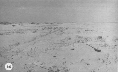
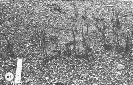
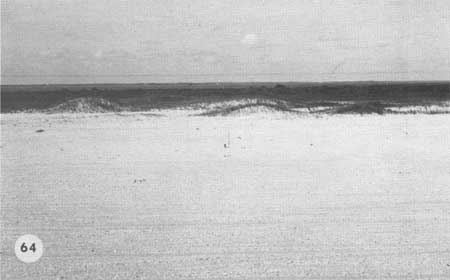
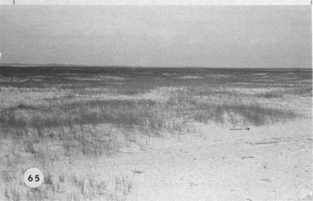
Dunes begin to form on the berm where seedlings of Uniola paniculata, Spartina patens, Cakile, and other plants take hold in drift lines or other locations (Fig. 60). The most important dune builder is Uniola, which requires burial and stratification to germinate (Wagner 1964). The drift which contains seeds acts as the first barrier to sand movement, and small dunelets form as sand is blown off the beach, berm, and overwash terraces. The first year after burial, seeds germinate and the seedlings begin trapping more sand (Fig. 61). By the second year (Fig. 62), the dunes become larger, as the Uniola trap more sand and grow upward through it. Within 4 or 5 years, dunes a meter or more in height can form, particularly where sand sources are readily available, such as well out on the berm or where the beach is at right angles to prevailing winds. If too far out on the berm (Fig. 63), the dunes will probably be destroyed by storms and the sand carried back by overwash. On islands oriented along prevailing winds and subject to continual overwash, the dunes are usually low and open, with numerous overwash passes (Fig. 64). Such dunes on Core Banks have appeared well back from the beach on overwash terraces created during the storms of the early 1960s. These dunes were formed, and are dominated, by Spartina patens and have grown to elevations of 1-2 m. Patches of Uniola occur on these dunes, and new dunes forming on the berm are primarily Uniola dunes. It is not clear why Spartina is the most common dune grass on Core Banks, since Uniola is dominant on Cape Lookout, Shackleford, and elsewhere. Uniola does, however, appear to be on the increase all along Core Banks. The vegetation of these low Spartina dunes (Fig. 65) is generally sparse; some of the species are Triplasis purpurea (sand-grass), Erigeron pusillus (fleabane), Hydrocotyle bonariensis, Eragrostis pilosa, Physalis maritima (ground-cherry), Croton punctatus (croton), and Oenothera humifusa (seabeach evening-primrose). Spartina is not as effective a dune builder as Uniola; it is not uncommon to find numerous dead Spartina plants, which appear to have died because sand was blown away from around their stems with resulting drought stress. Spartina patens has its best development where water is more readily available, such as the lower overwash terraces and high marsh, rather than in dunes. However, the most vigorous growth can often be found where fresh sand was carried onto a grassland by overwash or wind. In the dunes, interdune flats, and grasslands, Spartina patens grows erect. In the high marsh, however, it tends to be decumbent, as it is in the northern part of its geographical range. These erect, dune-forming Spartinas seem to be primarily a southern phenomenon. Recent tests in the Duke University Phytotron have shown that S. patens contains both erect and decumbent ecotypes, even from the same island transect (Hosier pers. comm.).
|
| Fig. 60. The beginnings of dunes on the open berm or bare sand flats are initiated by sea oats (Uniola paniculata) and Spartina patens. On more northern shores, American beach grass (Ammophila breviligulata) takes the ecological place of sea oats. Year old seedlings of sea oats are concentrated in the driftlines. Seeds are washed up on the berm with other flotsam and soon buried. If conditions are right, they germinate readily and create curving lines. Sea rocket (Cakile edentula) is a common annual which also germinates in the drift lines and can be seen in the foreground. |
|
| Fig. 61. Sea oat seedlings of the first year. |

|
| Fig. 62. By the second year, the sea oats are beginning to create small dunes on the berm, for which the open beach is a ready source of sand. |

|
| Fig. 63. In 4 or 5 years a major dune may form from what was a drift line. Dunes this close to the beach are usually knocked down by severe storms but the sand they contain is moved back into the island, not lost. |
|
| Fig. 64. The primary dune line on Core Banks is low because these islands are oriented in such a way that prevailing southwesterly winds blow sand off the beach rather than into the dunes. Overwash deposits between and behind the dunes are the source of material for dune growth. |
|
| Fig. 65. Close-up of Spartina patens dunes on Core Banks, with typical open vegetation. In this view the dunes are scattered, with overwash passes and flats between; there is no solid wall. |
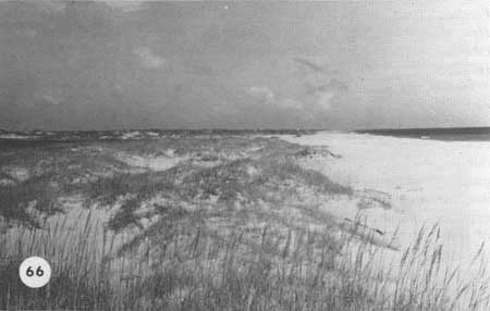
The natural dune zones on Cape Lookout and Shackleford Banks, as well as Bogue Banks and Hatteras Island, are dominated by Uniola and are well developed along those sections of beach that are oriented across prevailing winds (Fig. 66). These dunes grow rapidly, and the Uniola shows a vigorous response as long as fresh sand continues to blow in on the grass. Under favorable conditions such as on accreting beaches, usually those on a lengthening spit or in other areas of deposition, or during relatively long periods of storm absence or falling or stable sea level, continuous dune lines can form. Under such conditions, the earlier dunes can become stabilized by the beach grasses, and other species will invade the dune as the conditions become more favorable. In such cases, one sees the appearance of the classical patterns of salt-spray zonation in dunes, as described by Wells (1939), Oosting and Billings (1942), and Boyce (1954). Spray-resistant plants such as Uniola, Iva imbricata (seashore elder), and Cakile edentula face the sea, while less resistant species such as Andropogon scoparius (broomsedge), Parthenocissus quinquefolia (Virginia creeper), Erigeron pusillus, Heterotheca subaxillaris (camphorweed), Strophostyles helvola (wild bean), and Ampelopsis arborea (pepper-vine) colonize the backslope (Fig. 69).
|
| Fig. 66. Dune lines on Cape Lookout and Shackleford Banks are dominated by sea oats. Dunes grow tall here where the islands are at right angles to the prevailing winds. Even so, the vegetation is open on the first line of dunes, and numerous overwash passes break the continuity. |

|
| Fig. 67. Picturesque remnants of forest show through sea oats dunes on Shackleford. |
|
| Fig. 68. What was open, blowing sand in the early years of this century is now covered by sea oats with no help from man. In this view looking across Shackleford Banks, the remnant forest is visible, fronted by a new, stabilized barrier dune system. |

|
| Fig. 69. These large, naturally stabilized dunes on Bogue Banks have so far not been destroyed by developers. Here, classic salt spray zonation patterns as described by Oosting and Billings can be seen. The foredune face and crest are dominated by salt-spray resistant sea oats. In the lee of the dunes, the less tolerant broomsedge (Andropogon scoparius) can survive (the white patches on the right). Shrubs grow in the low areas in the center of the photograph, and on the rear dune to the left, sea oats again dominates. Behind this dune is the maritime forest. Such a dune system has open areas and blowouts as well as great diversity of species. |
In contrast to the more restricted dune zone on Core Banks, the dune system on Shackleford Banks, which lies across the prevailing winds, is much more extensive. Here, the fore-dunes lie relatively close to the beach and are in a state of continual build-up. Like the Core Banks dunes, however, the Shackleford fore-dunes are a maze with overwash passes between the dunes (Fig. 65). Storm tides are thus free to sweep into the dune zone with little resulting damage to the dunes. Instead of expending energy on a single dune line, the waves roll through a maze of overwash passes, with energy loss occurring within the zone. The presence of tree stumps in the Shackleford dune zone indicates that this region was once forested, and, as discussed earlier, the evidence shows these were living trees in the 19th century (Fig. 67). Apparently, a well-developed dune line existed seaward of those trees, and storms of the late 1890s and early 1900s cut away the protecting stabilized dunes, so that wind and wave could begin moving the sand back into the woodlands. The retreat was well underway in the early 20th century, causing considerable alarm (Lewis 1917). Since then, the migrating dunes have become relatively stabilized by natural growth of Uniola, and a new rear dune system has become stabilized well back in the center of the island (Fig. 68), with the forest surviving behind this dune region. Overwash on the western half of Shackleford is restricted to the fore-dune zone, since the dune system is high and well developed back from the beach.
The eastern half of Shackleford, however, is more like Core Banks, and this may be due to a more rapid retreat of the island in that region. Where the dunes are well developed and succession is underway, the zonation typical of Bogue Banks (Fig. 69) may become reestablished on the western half of Shackleford. Already, the more stabilized sections have woody vegetation invading what were once moving dunes. Even though many migrating dunes have become stabilized through natural means, large areas of open, moving sand still exist on Shackleford and bear witness to the much more extensive dune movement of years past.
Where man has been more directly involved in attempts to stabilize migrating dunes, such as on the Cape Hatteras Banks, extensive dune dikes now contrast sharply with the natural dunes of Cape Lookout National Seashore. In the past, it was considered essential to prevent dunes from migrating; all available advice, including that from scientists, recommended dune stabilization for the health and survival of the Outer Banks. It is not surprising, then, that many projects, especially during the 1930s, were organized to build fences, plant Ammophila breviligulata (American beach grass), and stop the moving sand. The results of such projects, which have continued up to the present, are now evident in the Cape Hatteras region. There is no doubt now that dunes can be stabilized if so desired. A man-made dune line (Fig. 70) now exists all along the Cape Hatteras National Seashore, except in those areas where natural dunes were previously present.

|
| Fig. 70. Continuous man-made stabilized dune on Hatteras Island, eroding on the seaward side. The American beachgrass is very dense due to heavy fertilization. The great density of vegetation on these man-made dunes is a distinctive feature of such stabilization programs and is not normally seen on natural dunes. There are few other species and no sand movement back of the dunes. Open areas in the grass are caused by disease and insect attacks. In such open areas, sea oats becomes established and lends a more natural appearance to the dunes. |
Methods of building artificial dunes have been well worked out (Woodhouse and Hanes 1967; Savage and Woodhouse 1968) and are widely used. Ammophila breviligulata is planted by machine and heavily fertilized. It forms a dense cover, trapping all sand that blows into it, so that the resulting dune grows very high and has a steep backslope, since no sand gets over the top.
One difficulty that arises in the managed strand is that the grass suffers from fungus and scale attacks, which seem to be aggravated by the density of the grass and the fact that the Outer Banks are south of the natural range of Ammophila. The diseases are beneficial in one way; they make openings in the dense stands of beach grass and let in Uniola paniculata, the native dune grass of the Southeast, and other species which help change the managed dunes into a more natural strand community.
Another problem with the managed dunes is that they are so high and present such an unbroken front against the sea that storm waves have no way to dissipate their energy except to chop away the front of the dune. Since the dunes have steep backslopes anyway, they tend to become very narrow and vulnerable. Dolan (in press) believes that the mere presence of the continuous, dike-like dune aggravates the erosion problem since the storm-wave energy is expended directly against the dune line rather than being dissipated over the island as on overwashed beaches with dune fields rather than lines. Waves crashing against the dune line cut away the base and the dune slumps into the water. Rebounding wave energy appears to further steepen the beach profile as the waves reflect back into the offshore zone. Other opinions suggest that the dune line is providing sand for beaches and in this sense is beneficial. Whatever the situation, those high, continuous dunes very close to the beach zone invariably are scarped and eroding, while those well back from the beach rarely show such effects.
The presence of stabilized dunes on the beach has also resulted in ecological changes behind the dunes. In those areas which once overwashed, the seaward dune line has allowed succession to proceed to such an extent that many areas now support shrub thickets rather than the open berm-zone or grassland community that previously existed. Vegetation more typical of the interior of these islands has migrated seaward with the protection against overwash and spray provided by the man-made dunes. Should such a trend continue, it is likely that plant communities will develop on the old berm that are not adapted to overwash. When the dune lines break, these communities may be obliterated completely and the normal return of overwash-adapted vegetation greatly delayed.
Natural dune-strand communities can develop on the berm, on overwash terraces, or on old inlet shoals wherever sand can be blown. The primary stresses in this habitat are moving sand and salt spray; other sources of stress are drought, lack of nutrients, and temperature fluctuations (Oosting 1954). However, the moving sand and the salt spray are also necessary nutrient sources, and where they are cut off by other dunes or by stabilization, the dune community declines. The way is then open for plants from the woodlands and thickets to invade the dunes.
Natural dunes have certain management advantages. The grass is sparse enough so that the sand can be moved by the wind, which keeps the dunes rounded rather than steep-sided; this shape is much better able to stand the physical forces of wind and wave. Dunes of this type are likely to migrate over other vegetation, but this is a necessary part of the dynamic stability of the islands. The natural dunes are also scattered about rather than in a solid wall, so storm waves flow between them and dissipate their energy gradually, without tearing everything down.
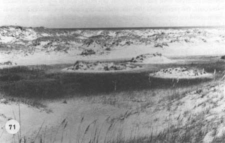
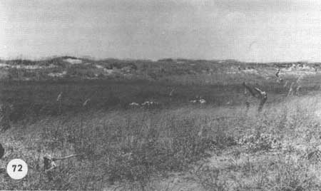
c. Dune slacks:
Interdune areas with elevations that dip down to the water table, such as blowouts, frequently contain a rather lush grassland vegetation that is often marsh-like depending on the ground-water level (Figs. 71 and 72). Aeolian removal ceases when the sand is wet, so the bottoms of dune slacks are usually level. Similar areas occur where migrating sand dunes have partially filled fresh-water marshes. These depressions are protected from salt spray and, if well within the dune zone, from overwash. They contain rather distinctive communities, with species from nearly all the grassland types, including marshes. The slacks are distinct from fresh-water marshes in that they tend not to have standing water during most of the year. In most cases, this grassland is dominated by Spartina patens, with important associates such as Fimbristylis spadicea, Scirpus americanus (three-square), Andropogon virginicus (broomsedge), Dichromena colorata, Setaria geniculata (foxtail grass), Juncus megacephalus and frequently Juncus roemerianus (black needle rush). Common herbaceous plants include Hydrocotyle bonariensis, Bacopa monnieri (water hyssop), Polygonum glaucum, Commelina erecta (dayflower), Diodia virginiana (button weed), Sabatia stellaris, Lippia nodiflora (frogbit), Qenothera fruticosa (sundrops), and vines such as Mikania scandens (climbing hempweed), and Cynanchum palustre.
|
| Fig. 71. Low interdune slacks and blowouts that reach the water table are normally dominated by Spartina patens, but slacks protected from overwash and spray develop a rich herbaceous flora. There is frequently standing water in the slacks after heavy rains. |
|
| Fig. 72. Large interdune slack on Shackleford Banks with a herd of feral goats. Livestock grazing here can easily reach the water table by digging. |
d. Mesic meadows:
Somewhat similar in environment and vegetation to the dune slacks are the extensive, low flats that are close to the water table, yet not associated with dunes. Such flats are usually very old overwash terraces or old tidal deltas no longer in the intertidal zone, or they are protected by seaward dunes and have not been overwashed recently. These sites are common where islands are relatively wide, such as at Guthrie's Hammock (Fig. 84). Except for the forests, these low, moist flats contain the greatest number of plant species. Water is near the surface, and may flood the lower sections, especially following heavy rains. The vegetation on these protected flats is complex and contains species from all the other grassland communities other than characteristic dune plants or intertidal marsh species. The flats are rich in grasses, sedges, and herbaceous plants. In general, the floristic composition is much like that of the dune-slack community except that the vegetation is much more extensive and contains more species. The aspect of these meadows varies with the season; in late summer the dominance of grasses such as Andropogon virginicus is very evident (Fig. 87). The species of the dune slacks are found here along with several species of Solidago (goldenrod), Gaura angustifolia, Lactuca canadensis (wild lettuce), Lythrum lineare (loosestrife), and the creeping Centella asiatica. Grasses such as Paspalum and various species of Panicum are common. Invading these flats are shrubs, with Baccharis usually the most common.
| <<< Previous | <<< Contents >>> | Next >>> |
chap3g.htm
Last Updated: 21-Oct-2005