|
BADLANDS National Park |
 |
Deposition of the Rocks
A vast period of time (probably around 3 billion years) preceded the creation of the badlands as we now know them. If you will look at the geologic time chart (p. 6), you will notice that a period called the Cretaceous began about 125 million years ago and ended some 60 million years ago. At the close of this period, the North American continent experienced widespread changes. These took place especially along the present Rocky Mountain range and to a lesser extent in the vicinity of the Black Hills. Up to this time, the land where these mountains now stand was comparatively flat. In it were shallow lakes, swamps, and wide plains crossed by sluggish streams. It was pretty much as central and eastern South Dakota is today. Then gradually but slowly, forces within the earth caused a buckling of the continent in a general north-south direction across most of the United States—along the present Rockies and also in the Black Hills region.
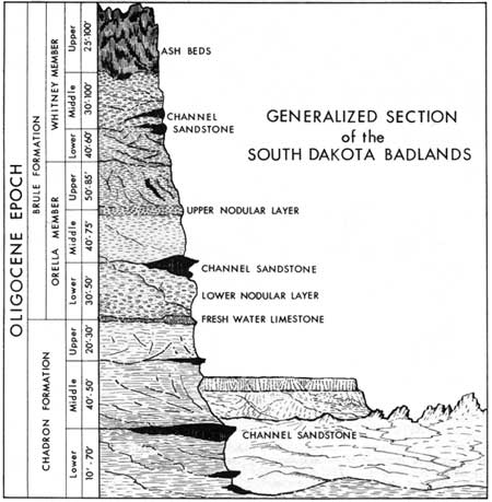
 Idealized stratigraphic section (click on image for an enlargement in a new window) |
In the uplifted areas, streams that once were sluggish now flowed more rapidly. Before this they were clear; but now they started to scour their channels. Their tributaries also dumped large quantities of mud, sand, and gravel into the main streams.
These rapidly moving waters carried their burden of sediment out of the mountains to where the country flattened out. Here the carrying capacity of the streams was reduced as the currents slowed down. This resulted in the deposition of sand bars, mudflats, and gravel banks along the course of the streams. These choked the channels and caused the water to fan out over wide areas. Depressions were filled with the sands and clays that the streams could no longer carry. This process continued throughout the long period when the Rocky Mountains and Black Hills were being pushed upward. It stopped only when the streams had graded their courses to a gently sloping bed. About 2,000 feet of sediments were laid down in this part of the Great Plains before the process ended.
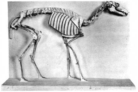
 Camels once lived in the badlands region. This camel skeleton, smaller than the skeleton of a sheep, is displayed in the museum of the South Dakota School of Mines and Technology SOUTH DAKOTA SCHOOL OF MINES AND TECHNOLOGY PHOTOGRAPH |
Toward the close of this period of deposition, a series of prolonged volcanic eruptions took place, principally in the Big Horn and Yellowstone regions. Huge quantities of volcanic ash were carried by westerly winds and dropped over western South Dakota. These accumulated in the badlands region to as much as 25 feet deep. In the vicinity of Sheep Mountain some of these ash deposits can be recognized by their chalky-white color. Much of the ash was washed away by the streams and redeposited on the flood plains in the same manner as were the clays. The older ash deposits are a rather dirty gray, compared to the younger white ash beds. The darker color indicates a larger amount of impurities present. These impurities are mostly bits of clay and silt, added, in the redeposition process, by the streams.
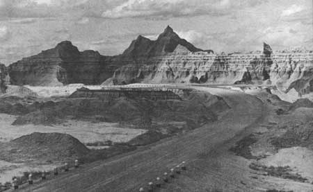
 The layering in the exposed rocks gives evidence of the method of their deposition RISE STUDIO PHOTOGRAPH |
The whitish color of the ash beds, even those of reworked material, stands out in rather sharp contrast to the pink, red, tan, brown, bluish gray, and gray of the other badlands rock layers. Generally speaking, the intensity of the red color is proportional to the amount of red iron oxide present. The various shades of tan and brown are produced by brown iron oxide, the same substance found on rusty iron. Gray colors are most frequently caused by the absence of organic matter. Occasionally, some purplish colors are noticed. These are believed due to the presence of manganese. Whatever the causes, the varied hues of the badlands spires and pinnacles have contributed to the fame of this eroded landscape. You'll see the colors at their best when they are intensified by rains and the light of evening or early morning.

|

|
|
|
|
Last Modified: Sat, Nov 4 2006 10:00:00 pm PST |


