|
Geological Survey Bulletin 1359
Geology and Mineral Resources of the Northern Part of the North Cascades National Park, Washington |
TABLE OF CONTENTS
Location and geography
Previous geologic studies
Present studies
Acknowledgments
Geology, by Mortimer H. Staatz, Rowland W. Tabor, Paul L. Weis, and Jacques F. Robertson
Rocks in the eastern part of the area
Custer Gneiss of McTaggart and Thompson (1967)
Light-colored gneiss
Banded gneiss
Amphibole-rich gneiss
Origin and age
Metagabbro
Phyllite and schist of Ross Lake
Hozomeen Group of Cairnes (1944)
Skagit Volcanics
Rocks in the western part of the areas
Greenschist and phyllite of Mount Shuksan
Chuckanut Formation
Hannegan Volcanics
Chilliwack composite batholith
Glaciation
Structure
Mineral resources, by Mortimer H. Staatz, Rowland W. Tabor, Paul L. Weis, Jacques F. Robertson, Ronald M. Van Noy, and Eldon C. Pattee
Setting
Geochemical exploration
Mineral occurrences
Disseminated sulfides
Veins
Placers
Description of mineralized areas
Silver Creek area
Pass Creek area
Red Face Mountain area
Little Beaver Creek area
Arctic Creek area
Luna Creek area
Big Beaver Creek area
West side of Picket Range between Mount Challenger and Mount Fury
Pioneer Ridge
Bacon Peak area
Sulphide basin area
Depot Creek area
Bear Creek area
Indian Creek area
Easy Ridge
Easy Creek area
Little Fork of the Chilliwack River area
Chilliwack River area
Hannegan Pass—Ruth Mountain area
Silesia Creek area
West Fork of Silesia Creek area
Index (omitted from the online edition)

|
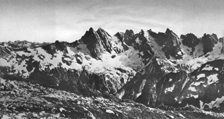
| Steep north face of the southern Picket Range. Small glaciers cling precariously to narrow chutes between towering spires. McMillan Creek behind the low ridge in foreground. |
ILLUSTRATIONS
PLATE
1. Geologic map of the northern part of the North Cascades National Park (omitted from the online edition)
2. Sample locality map of the northern part of the North Cascades National Park (omitted from the online edition)
FIGURE
FRONTISPIECE. Steep north face of southern Picket Range1. Index map showing location of the North Cascades National Park
2—8. Photographs showing—
2. Glaciers in the North Cascades National Park3. Custer Gneiss overlain by Skagit Volcanics
4. Custer Gneiss rock types
5. Custer Gneiss rock types
6. Thin-bedded chert in the Hozomeen Group
7. Well-foliated greenschist
8. Crinkled phyllite
9. Map of Bacon Peak—Hagan Mountain area
10. Map of Sulphide basin area
11—17. Photographs showing:
11. Arkoses interbedded with thin beds of black argillite of the Chuckanut Formation12. Hannegan Volcanics
13. Well-jointed quartz monzonite of the Chilliwack composite batholith
14. Sheared quartz diorite of the Chilliwack composite batholith 38
15. Rocks of the Chilliwack composite batholith
16. Glacial features in North Cascades National Park
17. Glaciers in North Cascades National Park
18. Map showing workings on the Weezie claim
19. Map showing Red Face Mountain and Pass Creek areas
20. Map showing Union Prospect in Sulphide basin
TABLE
TABLE
1. Analyses of samples from the northern part of the North Cascades National Park (omitted from the online edition)
UNITED STATES DEPARTMENT OF THE INTERIOR
ROGERS C. B. MORTON, SecretaryGEOLOGICAL SURVEY
V. E. McKelvey, Director
| <<< Previous | <<< Contents >>> | Next >>> |
bul/1359/contents.htm
Last Updated: 28-Mar-2006