|
Grand Teton
A Place Called Jackson Hole A Historic Resource Study of Grand Teton National Park |

|
CHAPTER 11:
Reclamation and Irrigation
We live in Wyoming and have seen and experienced the results of the damming of Jackson's [sic] and using the Snake River for a ditch.
—Editorial, Jackson's Hole Courier, January 13, 1921
|
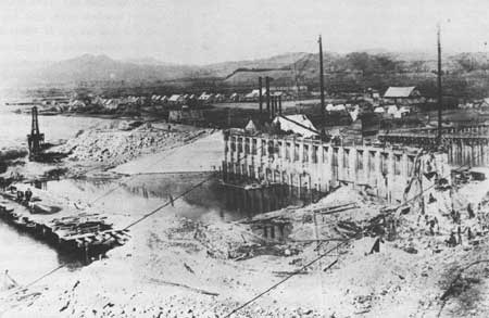
| Construction of Jackson Lake Dam, 1915. After the original log crib dam at the mouth of Jackson Lake failed in 1910, the Reclamation Service built a concrete dam, which was completed in 1916. The town of Moran is in the background. Jackson Hole Historical Society and Museum |
Major John Wesley Powell received much popular acclaim for being the first to successfully navigate the Colorado River in 1869. This extraordinary feat launched the "Major," as his friends called him, on a successful career; he became the second director of the U.S. Geological Survey and the founder and first director of the Bureau of Ethnology. Most remember him for these achievements. Powell is less well known for his astute, if somewhat visionary, ideas regarding land reform in the American West.
The Major recognized that much of the United States consisted of arid lands that required irrigation. This ran contrary to popular notions of the American West as a bountiful land wanting only stout settlers to make it blossom. A moist climatic cycle in the 1860s and 1870s reinforced this false perception. In his Report on the Lands of the Arid Region of the United States published in 1879, Powell advocated parceling out arid lands conforming to irrigation districts rather than according to rectangular sections and townships. Moreover, Powell believed that political entities should be formed around river drainages. [1]
Because of their experience in eastern states, where precipitation provided adequate water for crops, American farmers were slow to adopt irrigation. Prehistoric people had irrigated lands in the Great Basin and the Southwest long before the first Europeans came to North America, and the Spanish had irrigated farmlands in California in the eighteenth century. The Mormons were the first Anglo farmers to irrigate western lands successfully, when they developed farms and communities in the Great Basin. Through well-organized religious communities, they constructed an impressive mosaic of irrigation canals and ditches in the Salt Lake Valley. Despite Mormon successes, other settlers adopted irrigation slowly. [2]
|
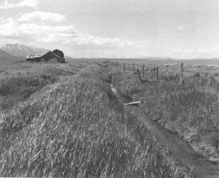
| Irrigation ditch on the Thomas Murphy homestead on Mormon Row. Virtually all of the irrigation projects in Jackson Hole were the products of individual or group efforts. Arnie Thallheimer |
In Wyoming, irrigation made slow inroads. Ranchers and farmers constructed small ditches along rivers and streams in the 1880s, but there were no large-scale projects. The Carey Act of 1894 and the Reclamation Act of 1902 spawned a flurry of activity as various interests sought water rights. Under the Carey Act, the federal government could donate up to 1,000,000 acres of land to designated desert land states, provided that state governments would promote irrigation, settlement, and cultivation of those lands. Wyoming was the first state to apply for these lands, seeking 457,500 acres. However, the application proved a dismal failure, as only 11,321 acres were patented. Indeed, critics of the Carey Act charged that companies applied to the state for water not to develop land, but to secure water rights to sell for use elsewhere. [3] Furthermore, private irrigation companies often avoided bidding on reclamation projects, because cost overruns caused them to lose money in most cases.
By 1897, Wyoming had approved eight projects, all initiated by private companies. The state charged homesteaders 50 cents per acre, while the companies were authorized to charge them $20 or more for perpetual water rights. Only two companies, Big Horn Basin Development Company and Buffalo Bill Cody's Shoshone Land and Irrigation Company, became more than grandiose schemes and even these failed. [4]
The Reclamation Act, passed by Congress and signed into law by President Theodore Roosevelt in 1902, authorized the federal government to reclaim land through water projects. The law allowed provisional withdrawals of land from settlement to prevent speculation. As the new Reclamation Service completed projects, settlers could preempt the withdrawn lands, paying for the irrigation systems through assessments based on acreage owned. In Wyoming, the Reclamation Service initiated three projects before 1910. The Service issued contracts for the construction of the Shoshone Dam near Cody, Wyoming, in 1904. The dam was completed in 1910. A permit in 1905 authorized the construction of the Pathfinder Dam on the North Platte River, which was completed in 1911. The Reclamation Service built a log crib dam at the outlet of Jackson Lake in 1906-1907. When the dam failed in 1910, they constructed the present concrete dam and earthen dike, completing the project in 1916. [5]
In the judgement of historian T. A. Larson, the Carey Act and Reclamation Act turned water reclamation into a "three-ring circus." "Before 1894 the whole show had been concentrated in one ring, where unalloyed private enterprise prevailed." [6] Under the Carey Act, states became involved in reclamation; and the federal government entered the field with the creation of a new bureau in 1902. The result was competition for water rights—and considerable confusion. All three players brought the "circus" to Jackson Hole.
In the private sector, there were four types of irrigation enterprises: individual and partnership projects; cooperative associations; irrigation districts (which were semi-public organizations); and commercial companies. Of these, individual and partnership activities dominated irrigation. For example, in 1919, this group accounted for more than one-third of all irrigated acreage in the West, followed closely by cooperative associations. [7] This was also the pattern in Jackson Hole, as individuals, partnerships, and groups accounted for all of the irrigation ditches in the valley.
In Jackson Hole, the Teton Irrigation Company tied up water rights and land in 1909 and 1912. The Types of Enterprise in United States company conducted surveys and filed paperwork, investing nothing in development. The Jackson Lake Dam represents lands irrigated by Reclamation Service projects. To this day, the water rights to the Jackson Lake Dam remain attached to farm lands in Idaho.
Under the federal system of government, individual states control water rights. After achieving statehood in 1890, the Wyoming legislature adopted a constitution that declared all water within its boundaries to be property of the state. The legislature also established a state board of control to supervise the "appropriation, distribution, and diversion" of water, and created a state engineer position to administer waters under its jurisdiction. Wyoming law attached water use to the land for which it was appropriated, whether for irrigation or other purposes. "Water rights for the direct use of the natural unstored flow cannot be detached from the lands, place, or purpose for which they are acquired." Thus, Wyoming water rights cannot be separated from the lands, as can be done in some states. [8] The standard allowance of water for irrigation purposes is one cubic foot per 70 acres, the amount of water that flows through one cubic foot of space per second. [9]
|
Acres Irrigated | ||
| Types of Enterprise in United States | 1919 | 1929 |
| Individual and partnership enterprises | 6,848,807 | 6,410,571 |
| Cooperative associations | 6,581,400 | 6,771,334 |
| Irrigation districts | 1,822,887 | 3,452,275 |
| Commercial companies | 1,822,001 | 1,230,763 |
| Carey Act | 537,929 | 86,772 |
| U.S. Bureau of Reclamation | 1,254,569 | 1,485,028 |
| U.S. Bureau of Indian Affairs | 284,551 | 331,840 |
| State | 5,620 | 11,489 |
| City and other | 47,952 | 267,462 |
| Total | 19,191,716 | 19,547,544 |
Source: Merk, History of the Western Movement. | ||
|
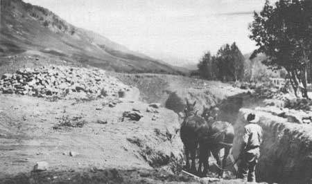
| Settlers digging an irrigation ditch from Flat Creek. Jackson Hole Historical Society and Museum |
Wyoming adopted the Prior Appropriation System of Water Rights, which basically means "first in time, first in right." Settlers possessing the first claims to water secured priority rights over later appropriators. This system becomes important in times of shortages, because available water is parceled out to appropriators based on the dates of their claims. A claim takes effect on the date it is filed with the state engineer. The state established the following procedures to secure water permits. [10]
File a petition for a permit with the state engineer.
The state board of control approves the petition or application, which allows the filer to start construction. The project must be completed in five years from start-up time.
The filer must accomplish the following:
a. Send notice of commencement of work to the state engineer.
b. Send notice of completion of work to state engineer.
c. Send notice of application of water for beneficial use to state engineer.
To secure final proof, the filer must notify the local superintendent of the water division. The state board of control reviews the application and issues a "Certificate of Appropriation," which conveys a water right to the filer.
A Certificate of Appropriation constituted an adjudicated water right. In his study of water rights in Grand Teton National Park, William L. Mekeel inventoried 258 appropriations now owned by the National Park Service. He also found 19 unadjudicated water rights, or those for which final proof papers were not completed. In addition, he identified 68 alien water rights, of which eight remained unadjudicated. Mekeel defined this classification as "those in which the irrigated land or place of domestic water use and/or the point of diversion and/or the means of conveyance are located with the park boundary." These numbers demonstrate the importance of irrigation to agriculture in Jackson Hole. [11]
Virtually all irrigation projects in Jackson Hole were the products of individual or group efforts. None of the ditches were engineering marvels, but nevertheless represented many hours of labor. According to the Tabulation of Adjudicated Water Rights for Water Division Number Four, D. H. Goe secured water rights to 2.28 cubic feet of water from South Twin or Twin Creek dating from June 10, 1883. Water was diverted through Holland Ditch Number 1 to a 160-acre parcel in the Flat Creek area. This water right may have belonged originally to John Holland, who secured the first water rights in Jackson Hole in 1883, according to another source. It was common for ditches to be named for their owners. The date of 1883 is inconsistent with popular tradition, which places the arrival of Holland and Carnes as 1884. [12]
Within the boundaries of the present Grand Teton National Park, homesteaders diverted water from several major tributaries of the Snake River; Pacific Creek, Spread Creek, Cottonwood Creek, Ditch Creek, Gros Ventre River, and the lower Snake River, which encompasses the areas in the park south of Moose, Wyoming. [13] The first ditch known to be excavated in Jackson Hole was the old Mining Ditch on Antelope Flats. As the name implies, unknown prospectors excavated a ditch to conduct placer mining on the Snake River. Orestes St. John, the geologist with the Hayden Surveys, described the ditch in his report of the 1877 survey. W. O. Owen plotted the course of the ditch on his survey map of Township 43 North, Range 115 West, 6th Principal Meridian in 1893. Owen's map shows a ditch approximately three and one-half miles in length, which diverted water from Ditch Creek at a point downstream from the present Teton Science School and ran a northwest course to Schwabacher's Landing on the Snake River. [14]
In 1896, James I. May and William Kissenger dug the first ditches for agricultural purposes in land comprising today's Grand Teton National Park. May excavated the Trail Ditch using a horse-drawn plow and hand tools. He used the water to irrigate 35 acres at the base of Blacktail Butte. Kissenger constructed a four-mile ditch to his homestead at Kelly Warm Springs. Homesteaders utilized water from the Gros Ventre and Ditch Creek to irrigate fields in the Mormon Row-Kelly area and on Antelope Flats. [15]
The first ditches taking water from the Gros Ventre were located in the Spring Gulch area. The earliest water right belonged to P. C. Hansen, whose priority dated from June 8, 1894. In 1898, five ranches secured rights to the Spring Gulch Ditch, which diverted water into the gulch. In the park, Nels Hoagland homesteaded west of Kelly with his four children. Filing for water rights in 1898, it took him at least four years to complete the Cedar Tree Ditch. Because of a lack of water, Hoagland was unable to plant a crop until 1903. [16] Plans to divert water from the Gros Ventre began in earnest in 1899, when Fred Lovejoy and George Kissenger filed for water rights to be diverted through the Midland Ditch. On July 31st of that year, Jim Budge, James May, Mart Henrie, and Joe Henrie secured water rights to 9.26 cubic feet of water, and constructed the Hot Springs Ditch above Kelly to divert water to 650 acres of land near Blacktail Butte. Other early ditches along the Gros Ventre were the Hobo, the Wild Cherry, the Sebastian, the Mesa, the Ideal, and the Savage. Rights to water coursing through these ditches date from 1899 and 1902.
Ditch Creek provided the other major waterway for irrigating lands in this area. James I. May tapped this creek with a headgate for the Trail Ditch while William Kissenger constructed a ditch to irrigate 65 acres at Kelly Warm Springs. Except for these two ditches, Ditch Creek remained untapped until 1907 or later, when settlers preempted lands around the creek. Several homesteaders rehabilitated and modified the old Mining Ditch, beginning with James Williams in 1908, O. H. Bark in 1909, E. C. "Doc" Steele in 1911, George Carpenter in 1912, and T H. Baxter in 1914. The Courier reported that A. Z. Smith, J. R. Smith, Carpenter, and Baxter were digging a ditch to their properties in 1914. [17] Between 1908 and 1930, 17 ditches were developed along Ditch Creek. Sometimes springs provided a water source. For example, Norm Smith obtained water from Pemble Spring on Blacktail Butte enabling him to irrigate 20 acres of his homestead.
In May 1927, water breached the natural dam at Lower Slide Lake on the Gros Ventre River causing the catastrophic Kelly flood. Irrigation works on the river were seriously damaged or destroyed. At that time, a group of farmers on Mormon Row had been excavating a canal from the Gros Ventre, each devoting several hours of work per week. They hoped to convert land being dry farmed for wheat and oats to irrigated hayfields. The flood ruined their work. But, for uncertain reasons, Mud Springs (today's Kelly Warm Springs) began producing more water after the Kelly flood. Settlers cut the Mormon Row Ditch to the springs and began irrigating dry lands. John Moulton, T. A. Moulton, Andy Chambers, J. Wallace Moulton, and Joe Heniger owned rights to nine cubic feet per second dating from 1929. To add even more water, settlers diverted water from Savage Ditch, cutting a channel to Mud Springs in the 1930s. The enlarged Savage Ditch added eight users to the system. As a result, Andy Chambers switched from dry farming to ranching, raising hay and cattle. [18]
West of the Snake River below Menor's Ferry, homesteaders began filing water rights around the turn of the century. Farmers and ranchers tapped water from Granite and Lake Creeks. P. C. Hansen and Albert Mangum secured rights to 3.49 cubic feet of water diverted from Granite Creek through the Granite Ditch. The priorities dated from 1898. Other early ditches irrigating lands were the Chicago, the John Miller, the Brown, the Kaufman, the Pemble Lake Creek, and the Nikolaison. Most of these ditches conveyed water to land located south of the park.
|
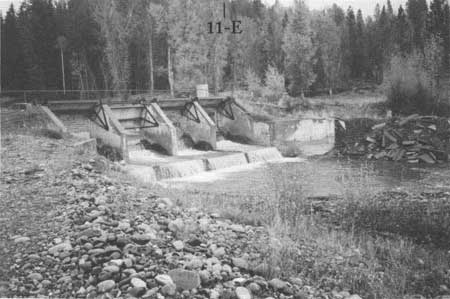
| Diversion dams served several farms and ranches, and were usually operated by a cooperating association. This dam, typical of many in Jackson Hole, is on Spread Creek. Grand Teton National Park |
In 1907, Bill Menor was the first to secure rights to water from Cottonwood Creek for his homestead on the west bank of the Snake. Struthers Burt and Horace Carncross secured rights to 7.05 cubic feet of water effective December 6, 1912, when they submitted an application to construct the Bar BC Ditch, a diversion of approximately five miles. Between 1914 through the 1920s, claimants filed for 25 permits to secure water from Cotton wood Creek and its tributaries, Bradley and Taggart Creeks.
Because of concentrated agricultural activity in the Spread Creek area, this watercourse and nearby tributaries became an important source of water. The first water rights dated from 1897, when five applicants sought to divert 8.29 cubic feet of water from Spread Creek through the Wolff Ditch. The owners of the rights were Marie Wolff, J. D. Ferrin, Emile Wolff, Otto Kusche, and J. H. Uhl. Since Ferrin and Kusche homesteaded after 1900, they may have taken over rights from previous claimants. In 1910, Wolff and Fred Cunningham constructed their own ditches; Wolff built the Elk Ditch, and Cunningham built the Antler.
After the creation of Teton National Forest in 1908, new lands were opened to settlement. In 1909, five settlers filed for water rights in the enlarged Wolff Ditch, then created an association of ten people. Other important ditches were the Jude V. Allen Ditch, and the J. P. Nelson Ditch. Because of the availability of water from sources such as springs and creeks, and the braided channels of Spread Creek, more settlers constructed their own ditches rather than form partnerships or cooperative groups. Twenty individual ditches were excavated in the Spread Creek drainage area. One ditch was constructed for placer mining in 1905, during a flurry of speculation in placer claims along the Snake River. The ditch was named for E. C. "Doc" Steele, a member of a loose partnership speculating in placer claims. Lydia Lozier secured a water right utilizing this abandoned ditch to carry the water to 128 acres at a later date.
On the Buffalo Fork and its tributaries there was less irrigation activity; none of the ditches or irrigated lands are in the park. Emil Feuz secured a priority to 1.76 cubic feet from the Buffalo Fork, effective 1913. Jack Shive obtained the first water right in this drainage in 1900, diverting water from Blackrock Creek. Noble Gregory secured a water right to almost two cubic feet of water from Lava Creek, effective 1902.
Limited irrigation took place in the Pacific Creek drainage near Moran. Charles J. Allen had the first adjudicated priority effective in 1899 for 2.28 cubic feet of water from Meadow Creek near Oxbow Bend. Joe Markham, Roy Lozier, and O. W. Snell constructed a ditch from Emma Matilda Creek to Markham's homestead on the east side of the Oxbow. Their priorities dated from 1919.
In 1928, the Snake River Land Company, the Rockefeller-sponsored Utah corporation formed in 1927, began buying homesteads in the valley, which included appurtenant water rights. The company intended to donate the lands to the National Park Service for incorporation into an expanded Grand Teton National Park. The prolonged controversy over park extension posed a problem for company officials. Wyoming state law specifies ". . . if the owner or owners of a ditch, canal or reservoir shall fail to use the water therefrom for irrigation or other beneficial use during any five successive years, they shall be considered as having abandoned the same and shall forfeit all water rights . . ." Other claimants can then apply for the abandoned rights. To prevent loss of these rights, the Snake River Land Company maintained and altered irrigation systems in the park and leased some lands for grazing, cultivation, or dude ranching. [19]
The company first spent money on ditches when local agent Dick Winger persuaded them to repair ditches on the Gros Ventre River destroyed by the Kelly flood in 1927. In 1936 and 1937, the company spent "several thousand dollars" constructing five miles of canal to irrigate 2,800 acres of land. Civil engineer John Simpson drew up plans to rehabilitate irrigation ditches south of Blacktail Butte. The project involved rehabilitating four and one-half miles of ditch and changing the diversion points and means of conveyance for the Enlarged Midland Ditch, the Enlarged Sebastian Ditch, the Enlarged Mesa Ditch, and part of the Enlarged Ideal Ditch. The company also improved the Newbold Canal and the Enlarged Sebastian Ditch. [20]
Using the old Elk Ranch holdings above Spread Creek as a nucleus, the Snake River Land Company fenced every purchased homestead between Spread Creek and the Buffalo Fork to raise hay for "wild game" and livestock. Cultivating hay required maintenance and improvements to existing ditches. In 1940, the company applied for a permit to reserve 423.3 acre feet of water to be stored in a reservoir to be located south of Uhl Hill. The company also modified the old Wolff Ditch to supply water from Spread Creek. In addition, it changed the diversion points and means of conveyance of the Jude V. Allen Ditch and Steele Ditch. In the early 1940s, the company built the Uhl Reservoir, an earthen fill dam 800 feet in length. The National Park Service took over several of the systems after 1950 and continues to maintain many of them in conjunction with extant grazing permits in the park. [21]
While Rockefeller's company represented corporate-backed irrigation, the Jackson Lake Dam epitomized federal involvement in reclamation efforts. Shortly after the passage of enabling legislation creating the Reclamation Service in 1902, surveyors entered Jackson Hole in September to conduct surveys of Jackson, Emma Matilda, Two Ocean, and Jenny Lakes. They evaluated the suitability of each for reservoirs. In 1907, the Reclamation Service completed a log crib dam at the outlet of Jackson Lake. The dam failed in 1910. The service launched an ambitious construction program, working through the winter of 1910-1911 to build a concrete gravity dam. It added an earthen dike on the north wing and rebuilt the dam, completing work in 1916. The dam raised the water level 39 feet and increased the area of the lake by one-third. The dam was part of the Minidoka Project, an ambitious reclamation program in the Upper Snake River valley. [22]
The dam's construction over the winter of 1910-1911 was a significant accomplishment, given the time frame, logistical problems, and severe weather. Frank Crowe, a prominent Reclamation Service engineer, directed the reconstruction in 1910, while Frank Banks supervised the remainder of the work from 1913 to 1916. [23] The dam impounded 847,000 acre feet of water to irrigate farmlands in Idaho. None was used for irrigation in Jackson Hole. Nevertheless, the project influenced development in the valley in a number of ways. It was the first major development project, private or public, in the valley and, as such, boosted the early economy significantly. The Reclamation Service employed numerous residents such as P. C. Hansen and others. In one of its social columns, the Jackson's Hole Courier reported that local settlers Aktor Nelson, Fred Topping, George Greenwood, and Samuel R. Wilson were employed by the Reclamation Service. [24]
|
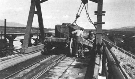
| The construction of the Jackson Lake dam was one of the largest government projects in Jackson Hole, providing employment and lucrative freight contracts for valley residents. National Park Service |
Others contracted to haul freight, shipping virtually all supplies for the project. Walt Germann, Gerrit Hardeman, Ben Taylor, Ray Shinkle, and Fred Shinkle freighted supplies over the Ashton-Moran Road. Si Ferrin received a windfall when he secured the contract to supply beef in 1914. According to Eliot Paul in Desperate Scenery, Ben Sheffield was not especially happy with the project, but certainly benefited financially from the workers' patronage of his store, restaurant, and guest accommodations at Moran. The economic impact rippled south to Jackson. Traffic between Moran and Jackson increased to such an extent that James I. May and his family operated a roadhouse out of their home on Mormon Row. In a few cases, entrepreneurs failed. E. C. "Doc" Steele opened a saloon near Moran around 1911, but abandoned it by the next year, after work slowed on the dam. [25]
Second, the project at Jackson Lake required more labor than the valley could provide, so the Reclamation Service brought in workers. A number of these men stayed in the area. Joe Pfeifer may have come to work at the new dam rather than to homestead. Dude rancher Harold Hammond hired on as stable boss to wrangle Reclamation Service horses. The service hired Joe Markham to serve as head timekeeper for the project. All three of these men homesteaded in the valley. Charlie Fesler was a cook for the service, who stayed on at Moran to run a mall grocery. [26]
Third, the sheer scale of the 1910 construction project posed logistical challenges as well as engineering problems. Frank Crowe recognized the need to improve the crude wagon road between Ashton and Moran before starting construction. He chose to link up with Ashton, because the Oregon Short Line served this community, and the three-day wagon trip was shorter than the Teton Pass route. For the next 17 years, this road served as an important supply corridor to the upper end of the valley. [27]
If there was any opposition to the construction of the dam it was not apparent. The reclamation effort represented unabashed western boosterism as a triumph of man over nature. Eliot Paul's autobiographical novel Desperate Scenery reflected the "can do" spirit that characterized attitudes about the project. Contrast this with Owen Wister's opinion of the dam; "And here let me pause to lay my ineffectual but heartfelt curse upon the commercial vandals who desecrated the outlet of Jackson's Lake with an ugly dam to irrigate some desert land away off in Idaho." [28]
The Jackson Lake Dam played a part, albeit indirectly, in generating opposition to other reclamation projects in Jackson Hole and Yellowstone. Struthers Burt described Jackson Lake as "an example so good that it is constantly being used as an object-lesson by the enemies of stupid spoilation." In particular, a significant number of valley residents opposed a plan put forth by Frank Emerson, state engineer and later Governor of Wyoming, to construct a dam at the outlet of Jenny Lake. Opponents used Jackson Lake's fate as an "object lesson" in spoiled mountain scenery; the Reclamation Service failed to cut and clear thousands of predominantly lodgepole pine trees that were killed when inundated by raising water levels. The result was an unsightly tangle of dead trees around the shore of Jackson Lake. The Civilian Conservation Corps cleaned up 8,000 acres of shoreline in the 1930s.
In another instance an editorial appeared in the Jackson's Hole Courier in 1921 titled "Remember Jackson's Lake" that opposed a proposed dam on the Fall River in Yellowstone National Park. This was a significant departure for a paper that opposed the proposed Yellowstone Extension into the Teton Country. The editorial stated "we live in Wyoming and have seen and experienced the results of the damming of Jackson's [sic] and using the Snake River for a ditch."
Property damage, inconvenience, and resentment over other states benefiting from Wyoming dams mobilized sentiment against reclamation projects. The Courier editorial complained that the Reclamation Service had allowed excessive amounts of water out of Jackson Lake, washing away private land and causing "thousands of dollars in damage." The Ferrins, the Bar BC, and the Cadwalader Ranch suffered the most damage. In 1917, when high water on the Snake washed away the approaches to the new steel truss bridge between Jackson and Wilson, local residents blamed the Reclamation Service for releasing too much water from Jackson Lake. In turn, the service blamed local officials for not riprapping the approaches properly. Teamsters were forced to transport mail and supplies 20 miles north to Menor's Ferry and back again causing considerable delays in mail and freight service. Whether the dam at Jackson Lake caused thousands of dollars of damage is questionable, but the point is that some valley residents perceived reclamation projects as bad. [30] The approaches to the Wilson bridge were moved downstream a short distance, and the bridge repaired in 1922 with county, state, and private funds. This time workers constructed an adequate system of levies and riprap. Despite beliefs of local citizens, the Reclamation Service appears not to have been responsible, for it was never taken to court nor ordered to pay for damages.
Another controversy developed over the dam in 1921 when Teton County, authorized by the state legislature, tried to assess property taxes for reserved water rights on Jackson Lake. Early in 1924, the Twin Falls Canal Company and the North Side Canal Company, both Idaho corporations, filed an in junction in the U.S. District Court in Cheyenne, Wyoming, seeking to prevent the assessment of $12,000 in taxes. In September 1925, Judge Blake Kennedy ruled that the water rights on Jackson Lake were taxable. Company attorneys appealed the decision. An appeals court reversed Kennedy's decision in 1926. The court held that since the water rights were appurtenant or attached to lands in Idaho, Teton County had no right to tax them. [31]
Entrepreneurs and state officials proposed other water reclamation projects in Jackson Hole, but none ever progressed past the planning stage except for headgates installed at Emma Matilda and Two Ocean Lakes. The first proposal was grandiose, initiated under the auspices of the Carey Act of 1894. As explained earlier, this law encouraged the reclamation of arid lands by conveying title of newly irrigated acreage to states. In turn, states generally contracted with private companies to construct irrigation facilities. In 1909, Charles C. Carlisle and H. G. Porak proposed the Buffalo Fork Canal, a major diversion intended to irrigate 29,078.5 acres east of the Snake River from the Buffalo Fork to the Gros Ventre. They estimated that it would cost $60,000 to construct a 20-mile canal, 36-feet-wide at the top and 26-feet-wide at the bottom, capable of holding five feet of water in depth. The state engineer approved the proposal on May 7, 1909. The Teton Irrigation Company, as Carlisle referred to it, had one year to commence work, five years from commencement to finish work, and ten years to complete proof of beneficial use.
In 1912, Carlisle submitted a modified proposal for a canal system to divert water from Spread Creek south to the Gros Ventre River. The proposed Spread Creek Canal was 12-1/2 miles long, 20 feet wide at the top, 12 feet at the bottom, capable of carrying water four feet deep. Although this plan was more modest, proposing to irrigate 6,413.32 acres, it would feed a large network of canals, the Enlarged Spread Creek, the North Ditch Creek, the South Ditch Creek, and the Gros Ventre. Carlisle estimated the cost to be $35,000. As far as is known, the company never so much as lifted a shovel. Indeed, in 1914, settlers became restless over the company's tied-up water rights and land, complaining "they have done nothing in two years." The General Land Office opened the lands to settlement in 1922, after the company failed to develop an irrigation system. [32] Carlisle's scheme has been clouded by charges of fraud. Struthers Burt was convinced that such projects were never intended to irrigate lands in Jackson Hole, but to divert water to Idaho for a healthy profit. [33]
In 1918 and 1919, homesteaders in the Pacific Creek area began filing for water rights to Emma Matilda and Two Ocean Lakes and their creeks. H. C. McKinstry, William C. Thompson, Joe Markham, Roy Lozier, and O. W. Snell applied for seven permits. Markham, Lozier, and Snell diverted 5.52 cubic feet of water from Emma Matilda Creek through the Markham Ditch to their homesteads along the Snake River. McKinstry and Thompson diverted water from Two Ocean Creek to their properties. The three men were prevented from securing rights-of-way by the presidential executive order of 1918 prohibiting all forms of entry on more than 600,000 acres situated within the Teton National Forest, pending resolution of the Yellowstone Extension. The executive order allowed the National Park Service to veto any undesirable developments. However, Superintendent Horace Albright of Yellowstone interceded on their behalf and the rights-of-way for ditches were granted. [34]
In addition, McKinstry reserved 512 acre feet of water from Two Ocean Lake with a priority date of May 1, 1918, and Markham filed for 1,710 acre feet of water on Emma Matilda Lake on August 18, 1919. A year later, the Courier reported that a group of Idaho ranchers of the Osgood Land and Livestock Company purchased the W. S. Thompson Ranch below Two Ocean Lake along with the water rights of six ranches in the Pacific Creek area. The editor of the Courier used this development to rail against the Reclamation Service for using the Snake as a ditch and destroying the Wilson bridge, then criticized "Cheyenne interests," meaning Charles Carlisle, for closing up land to settlement. Actually, neither the Reclamation Service nor the Teton Irrigation Company had any connection with the Idaho company. To complicate matters, Carlisle filed a proposal to construct the Twin Lakes dams at the two lakes in 1919. State Engineer Frank Emerson approved the proposal, but like Carlisle's other schemes, it came to nothing. [35] The Osgood Land and Livestock Company constructed headgates at both Emma Matilda and Two Ocean Lakes in the early 1920s and began diverting water to Idaho. In 1921, the Utah-Idaho Sugar Company purchased the water rights. [36]
Beginning in 1928, the Snake River Land Company began purchasing homesteads. Between 1928 and 1931, they bought the Markham, Lozier, Snell, McKinstry, and Thompson homesteads. This set the stage for litigation. In 1935, company attorneys and agents began putting together legal briefs and reports to challenge the Utah-Idaho Sugar Company's water claims. The Snake River Land Company argued that they had purchased the same water rights since they were appurtenant to the lands. They based their case on Wyoming state law, which stated that "water rights for the direct use of the natural unstored flow of any stream cannot be detached from the lands, place or purpose of which they are acquired." In other words, the company challenged the legality of the earlier sale of water rights. The suit began with a hearing before the state engineer in 1938 and went through the Wyoming State Supreme Court in 1942. Each appeal affirmed that water rights could not be separated from the lands to which they were appurtenant. The Utah-Idaho Sugar Company lost all appeals and, consequently, their claims to water rights, and the case set an important precedent confirming the validity of Wyoming water laws. The dams at Emma Matilda and Two Ocean Lakes were removed in the early 1950s. [37]
The second scheme emerged in 1919; State Engineer Frank Emerson proposed a dam at the outlet of Jenny Lake for irrigation purposes in the wake of the 1919 drought that devastated much of the American West. The proposed dam would have raised the water level of Jenny Lake 20 feet and the level of Leigh Lake ten feet. A small but vocal group of Jackson Hole residents were aghast and sought to block the project. Struthers Burt wrote, "they were going to dam one of the near-by lakes—incidentally ruining the lake, a lake which is as beautiful as any in the world. . . ." Opponents found the Forest Service no ally, for while the service did not support the project, neither did it oppose it. The National Park Service employed the 1918 executive order to prevent a dam at the outlet of Jenny Lake. This controversy mobilized support for conservation among a small group of valley residents. More important, these people began to perceive the National Park Service as an ally in their effort to protect Teton country from commercial exploitation. [38]
Aside from the Jackson Lake Dam, large-scale irrigation projects proved to be failures. The Carey Act of 1894 generated no successful reclamation projects in Jackson Hole. Indeed, critics such as Struthers Burt and Dick Winger believed that entrepreneurs had no intention of reclaiming Jackson Hole lands, but in reality sought water rights to sell to the highest bidder. The history of irrigation in Jackson Hole fits the pattern that occurred elsewhere in the American West. Individual, partnership, and group efforts accounted for virtually all irrigation systems in Jackson Hole. Homesteaders constructed the ditches in the park between 1896 and 1927, and it is probable that they used hand tools and horses to build them. These systems were small-scale. Even the largest ditches seldom exceeded ten appropriated users, and most ditches were no more than three miles in length.
Notes
1. Goetzmann, Exploration and Empire, pp. 541-551 and 582.
2. Merk, History of the Western Movement, pp. 507-508.
3. Larson, History of Wyoming, pp. 301-304 and 347- 348; and Struthers Burt, Diary, pp. 111-125.
4. Larson, History of Wyoming, pp. 303-304.
5. Larson, History of Wyoming, pp. 355-357; and Merk, History of the Western Movement, p. 509.
6. Larson, History of Wyoming, p. 348.
7. Merk, History of the Western Movement, p. 508.
8. William L. McKeel, "An Interdisciplinary Overview of the Water Resources of Grand Teton National Park," unpublished ms. (Laramie, WY: University of Wyoming. 1972), pp. 77-85.
10. William McKeel, "Water Rights in Grand Teton National Park," unpublished ins., n.d., Grand Teton National Park, pp. 7-8.
12. Jackson Hole Guide, April 20, 1967, and October 24, 1968; and McKeel, "Water Rights," see Tabulation of Adjudicated Water Rights. This source is used for the remaining narrative unless otherwise noted.
14. St. John, "Report of Orestes St John," Eleventh Annual Report, p. 445; William O. Owen, T43N, R115W, 6th P.M., 1893, Jackson Hole Plat Book, Harold and Josephine Fabian Collection, Grand Teton National Park.
15. Interview with Clark Moulton by Jo Anne Byrd, #27, in "Last of Old West Series."
16. Homestead Patent, Homestead Cert. 469, Lander, Nels Hoagland, 1903.
17. Jackson's Hole Courier, May 17, 1914.
18. Interview with Clark Moulton, #27; Jackson's Hole Courier, November 8, 1945; Jackson Hole Guide, May 20, 1976.
19. McKeel, "Water Rights," and transcript of testimony, Snake River Land Co. vs. Utah-Idaho Sugar Co., June 1, 1938, Rockefeller Archive Center, Harold P. Fabian Papers, 1V3A7, Box 15, File 110.
20. U.S. Congress, Senate, Subcommittee of Committee on Public Lands and Surveys, "A Resolution to Investigate the Questions of Enlarging Grand Teton National Park in Wyoming; Hearing on S. Res. 250," 75th Cong., 3rd sess., 1938, p. 217; and Newbold Canal, Plat #3, Jackson Hole Plat Book, Fabian Collection, Grand Teton National Park.
21. Uhl Reservoir, Plat #12, Uhl Supply Ditch, Plat #13, Jackson Hole Plat Book, Fabian Collection, Grand Teton National Park.
22. "Reconnaissance Books," Vols. 2-4, Reclamation Service, 1902, Grand Teton National Park, John Markham, "The Temporary Jackson Lake Dam" MSS167B, H70-114, Wyoming State Archives, Museums and Historical Departments; and "Jackson Lake Dam," Determination of Eligibility, Wyoming State Historic Preservation Office.
23. Markham, "The Temporary Jackson Lake Dam."
24. Ibid., and Jackson's Hole Courier, August 13, 1914.
25. Markham, "The Temporary Jackson Lake Dam;" John Markham, "Biography of Mr. Joseph James Markham," biographical files, Wyoming State Archives, Museums and Historical Department; Paul, Desperate Scenery; interview with Clark Moulton, #27; and Allen, Early Jackson Hole, p. 66.
26. Jackson Hole News, November 22, 1972; and Markham, "Biography of Joe Markham."
27. John Markham, "The Ashton-Moran Freight Road, 1910-1927," Pamphlet File, Grand Teton National Park Library.
28. Paul, Desperate Scenery; Jackson Hole News, November 16, 1972, November 22, 1972; and Jackson Hole Guide, September 19, 1973.
29. Righter, Crucible for Conservation; and Struthers Burt, Diary, p. 121.
30. Jackson's Hole Courier, January 6, 1921, and January 13, 1921.
31. Jackson's Hole Courier, April 10, 1924, October 1, 1925, and December 30, 1926.
32. "Buffalo Fork Canal Application for a Permit to Divert and Appropriate Water in the State of Wyoming," May 7, 1909; "Spread Creek Canal Application for a Permit to Divert and Appropriate Water in the State of Wyoming," December 23, 1912; C. C. Carlisle, "Map of Teton Irrigation Project," June 23-July 6, 1912, October 29, 1912-November 4, 1912, Grand Teton National Park; and Jackson's Hole Courier, April 16, 1914, and March 10, 1927.
33. Struthers Burt, Diary, pp. 111-125; and Murie, Wapiti Wilderness, pp. 117-118.
34. McKeel, "Water Rights;" "Hearings on S. Res. 250," 1938, p. 283; Righter, Crucible for Conservation, p. 32; and Jackson's Hole Courier, October 19, 1919.
35. Jackson Hole's Courier, April 22, 1920; and Docket II, Twin Lakes Reservoir and Supply Ditch, Grand Teton National Park.
36. Fabian Papers, Rockefeller Archive Center, Box 15, File 110, Transcript of Hearing, Snake River Land Company vs. Utah-Idaho Sugar Company, June 1, 1938.
37. Docket 9, Snake River Land Company, Protestant vs. Utah-Idaho Sugar Co., Water Rights Files, Grand Teton National Park.
38. Struthers Burt, Diary, pp. 118-119; and Righter, Crucible for Conservation, p. 32.
| <<< Previous | <<< Contents >>> | Next >>> |
grte/hrs/chap11.htm
Last Updated: 24-Jul-2004