|
Grand Teton
A Place Called Jackson Hole A Historic Resource Study of Grand Teton National Park |

|
CHAPTER 4:
Explorers and Scientists
He was the slim, bearded, white man who always carried a bag over his shoulder and a little pick in his right hand and who darted from one dry run to another, climbed up buttes and escarpments, picked at the rocks, and then went on. Once, a party of braves had surrounded him and dumped the contents of his bag onto the ground. It had nothing but rocks. So thinking him loco, they had given him a name that meant "man-who-picks-up stones-running" and let him go.
His real name was Ferdinand Vandiveer Hayden, M.D.
—Richard A. Bartlett, Great Surveys of the American West
|
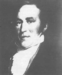
| William Clark. William Clark and Meriwether Lewis headed the "Corps of Discovery"; their mission was to explore the newly purchased western lands and find a water route to the Pacific Ocean. National Park Service |
When Meriwether Lewis and William Clark set out on their epic journey in 1804, Americans knew little of the North American continent west of the Mississippi River. President Thomas Jefferson considered the expedition so important that he wrote the orders for the expedition himself, and participated actively in planning the enterprise. Jefferson prescribed objectives that set standards for later government explorers. Lewis and Clark launched 75 years of government surveys that lasted until the late 1870s. [1]
Manifest Destiny became the nation's rallying slogan in the 1840s. Proponents of this doctrine believed that it was the destiny of the United States to expand over the North American continent. No one personified this idea more than John Charles Fremont. A member of the Army's Corps of Topographical Engineers, Fremont led his first expedition to the Rockies in 1842. Mapping a route for emigrants to Oregon, Fremont crossed South Pass into the Green River Basin, then turned north along the Wind River Range. He climbed what he thought was the tallest peak in the range, known today as Fremont Peak. Describing the day as "sunny and bright," Fremont "could just discover the snowy heads of the Trois Tetons" in the distance. He led several more surveys west, but this was as close as he ever came to Jackson Hole. [2]
Later surveys concentrated on locating a route for a transcontinental railroad. The need for such a link was both symbolic and practical. After the Mexican War ended in 1848, the United States spanned the continent from east to west, and hence required a reliable transportation route to secure political and economic ties and to defend the new western empire. Moreover, the transcontinental railroad symbolized the nationalism of the country. Unfortunately, intense sectional rivalries fueled by the issue of slavery tainted rational debate concerning an eastern terminus and route. Protagonists believed that the region securing the eastern terminus would enjoy overwhelming and permanent economic advantages over others. The issue pitted not only North against South, but communities and states against each other. No one seemed to accept the possibility of more than one transcontinental railroad. [3]
In 1853, Congress allocated funding to survey practicable routes to the Pacific Coast, charging the War Department with the task. Isaac I. Stevens, a former army officer, surveyed the northern route between the 47th and 49th parallels. Lieutenant John W. Gunnison led the 38th parallel survey, which covered an area through the Colorado Rockies and central Utah. The 35th parallel survey scouted from Fort Smith, Arkansas, to Santa Fe, then on to California. Lieutenant A. W. Whipple directed this survey. Two survey parties reconnoitered the 32nd parallel, which crossed Texas, New Mexico, and Arizona. The 38th parallel survey explored the general area of the eventual alignment of the first transcontinental railroad from southwestern Wyoming to the Pacific Coast. None of the surveys evaluated a route through Jackson Hole.
Influential citizens in Washington Territory (which included what is now the states of Washington, Idaho, and parts of Montana and Wyoming) supported a railroad over South Pass with branches to San Francisco and Puget Sound. Consequently, they were disappointed with Stevens's recommendation for a northern route through Montana to Puget Sound. As a result, the Washington Territorial Legislature provided funds for the survey of a South Pass route. A civil engineer named Frederick West Lander conducted the survey. Lander surveyed south of the Teton Range and Jackson Hole, essentially following the Oregon Trail. [4] The United States Government published the surveys in a preliminary report in 1855, but Congress failed to agree on a route as the slavery issue inflamed sectional rivalries over the eastern terminus of the railroad. The Union stood on the threshold of dissolution and war when Captain W. F. Raynolds expedition entered Jackson Hole in 1860.
Raynolds's expedition was the first of three military surveys to pass through Jackson Hole. A member of the Army Topographical Engineers, Raynolds was instructed to explore the upper Yellowstone, Gallatin, and Madison Rivers. Like so many military surveys, Raynolds was to "ascertain the numbers, habits and disposition of the Indians inhabiting the country . . . as the army scouted potential opponents." [5] Further, Raynolds was to survey agricultural and mineral resources, climate, and, in particular, potential rail or wagon roads "to meet the wants of military operations or those of emigration through, or settlement in, the country." [6]
After travelling up the Missouri River by steamboat to Fort Pierre, South Dakota, the survey set out overland on June 18, 1859. Raynolds employed none other than Jim Bridger as a guide. Also accompanying the expedition was a young physician who exhibited a passion for geology and paleontology. He was Ferdinand Vandiveer Hayden, the organizer and leader of the post-Civil War Hayden Surveys. The military surveys of this period inventoried the flora, fauna, and geology of the West as a matter of course. Respected institutions such as the Philadelphia Academy of Sciences, the Albany Academy, and the Smithsonian Institution sent scientists with these expeditions. As a result, a new perception of the American West emerged; scientists saw it as a gigantic natural laboratory. The scientist was a frontiersman, as much so as the soldier and mountain man. Yet, he perceived the West's natural resources in a much different light; they were most important for the knowledge that could be gleaned from them. Thus, in the Raynolds's expedition, mountain man, soldier, and scientist merged in the surveyors frontier. [7]
Jim Bridger guided the party across the badlands of South Dakota, past the Black Hills, and west to the Yellowstone River. Hayden's penchant for wandering off to collect rock and fossil specimens caused Raynolds and Bridger considerable worry. On August 11 or 12, 1859, on Rosebud Creek, Raynolds noted, "Dr. F. V. Hayden, geologist, had departed for Wolf mountains in such a state of scientific obsession as to neglect to obtain permission. Hayden was missing for at least one night. He returned August 13, "happy in having examined the mountains." Always the soldier, Raynolds ordered "that no one should thereafter be absent overnight without express permission." [8] Later, on the Little Bighorn, Hayden asked to examine a nearby bluff, but Raynolds denied the request "as Mr. Bridger was very decided as to the danger of parties going abroad alone while there were evidences of the vicinity of Indians, and as I could not encourage unnecessary work on the Sabbath." [9] As winter approached, the expedition found abandoned cabins along Deer Creek near present day Glenrock, Wyoming, where they holed up until spring. A very religious man, Raynolds espoused his faith and apparently tried to convert Hayden. Soldier, mountain man, and scientist must have spent a long winter on Deer Creek, broken only by the vivid yarns of Jim Bridger and other mountain men.
Raynolds's party moved out on May 8, 1860. They intended to follow the Wind River to its headwaters and cross a divide to the headwaters of the Yellowstone. In late May, Raynolds tried to cross the Continental Divide. Bridger warned against this, stating that it would be necessary to cross into the Columbia drainage before seeking the headwaters of the Yellowstone. Ignoring his advice, Raynolds found his way blocked by a basaltic ridge, "rising not less than five thousand feet above us." Bridger remarked to Raynolds: "I told you you could not go through. A bird can't fly over that without taking a supply of grub along." They returned to the Wind River, where Bridger determined to guide them over Union Pass. [10]
Thus, terrain and snow forced the Raynolds's survey to seek a route through Jackson Hole. On May 31, they set out. Bridger assured them that they would camp that night on the waters of the Columbia within five miles of the Green River. Steep slopes and deep snow hindered their progress so much that "Bridger for the first time lost heart and declared that it would be impossible to go further." The expedition floundered, but eventually reached the Continental Divide completing this "most laborious" march since leaving Fort Pierre. Raynolds named the divide, Union Pass, and the nearby summit, Union Peak. On June 1, the survey party trekked down the Gros Ventre Fork valley. Snow and deep mud exhausted both men and stock. Here, Jim Bridger lost his bearings. Although he knew the general area well, Bridger's memory for details seems to have failed him. He tried unsuccessfully to find a way through the Mount Leidy Highlands to Togwotee Pass and Two Ocean Pass. The snow and rugged terrain foiled him. Disappointed, Raynolds determined to follow the Gros Ventre west. He recorded, however, that Hayden and his assistants remained busy collecting specimens, despite the ordeal. [11]
|
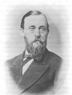
| Ferdinand V. Hayden led some of the most notable surveying expeditions of the Yellowstone and Jackson Hole area. National Park Service |
"Flower-painted meadows" greeted the expedition when they entered Jackson Hole. The Snake River presented another obstacle. It was a roiling torrent, fed by the spring runoff from the surrounding mountains. They traveled south seeking a safe crossing, but tragedy struck when one man drowned while testing a ford. Raynolds then ordered a raft built, which promptly failed a trial run. Meanwhile, Bridger had begun fashioning a bullboat of poles, blankets, and lodge skin. Using the boat, they ferried their gear across three 100-yard channels losing only the wheels to the odometer. They spent three days crossing the river. On June 18, Bridger guided the expedition over Teton Pass into Pierre's Hole. [12]
The survey followed the Madison River, then the Missouri River, back to Fort Pierre. Raynolds failed to locate the upper Yellowstone River. Why Jim Bridger did not follow the Wind River then divert to Togwotee Pass and Two Ocean Pass remains a mystery. Even more puzzling was the decision to cross Teton Pass rather than travel north through Jackson Hole to Two Ocean Pass. Both routes would have enabled Raynolds to locate the headwaters of the Yellowstone. There are two explanations. Bridger may have felt the snow would be too deep to try either route, or the passing years may have dimmed his memory. It is clear that he became confused in the Upper Gros Ventre River country for Raynolds observed that Bridger seemed "more at a loss than I have ever seen him. . . ." [13]
Nevertheless, the Raynolds survey is significant for several reasons. It was the first government survey to explore Jackson Hole; and for the first time scientists turned their attention to this area and collected specimens. It was also during this survey that Raynolds gave Union Pass its name. The presence of Jim Bridger linked the fur trappers' frontier to the explorer and surveyor's frontier. Finally, Raynolds concluded in his report that the Jackson Hole and Yellowstone country were too mountainous for a railroad.
While Raynolds conducted his surveys, divisions over slavery escalated in the United States. Abraham Lincoln's election to the presidency fractured the Union in 1860, and when the volunteer army of the seceded states opened fire on Fort Sumter in April 1861, they hurled the nation into its bloodiest war. Exploration in the West came to a halt. After the Civil War ended in 1865, military surveyors again looked to the western horizon.
In 1873, Captain William A. Jones, Army Corps of Engineers, was ordered to reconnoiter an area from Fort Bridger, Wyoming, to the Yellowstone country. He sought to locate a military road, linking the Yellowstone and the Montana settlements with the Union Pacific tracks. Jones assembled a party of specialists that included Theodore B. Comstock, geologist; Dr. C. C. Parry, botanist; C. L. Heitzman, surgeon and chemist; and Lt. S. E. Blunt, astronomer.
The Jones expedition set out from Fort Bridger in June 1873. Their route took them through the Green River Valley, over South Pass, up the Wind River, where they crossed the Owl Creek Mountains into the Bighorn Basin. When they reached the Shoshone River (then called the Stinking Water), Jones turned west into Yellowstone Park. The survey made a loop through the Yellowstone country, spending the month of August in the new national park. South of Yellowstone Lake, their Shoshone guides rebelled, stranding the expedition in the Thorofare country. Jones enticed them to continue with promises of food and new respect. However, all of the Shoshone were lost except for one, and he proved unreliable. The party finally made their way up the Yellowstone River, crossed Two Ocean Pass, traveled down Lava Creek, then up Blackrock Creek to Togwotee Pass. Rediscovering this pass, Jones named it for one of the guides. In his 1875 report, Jones recommended the construction of a wagon road from the Union Pacific line across Togwotee and Two Ocean Passes into Yellowstone Park. However, the road was never built. [14]
In 1876, Lieutenant Gustavus Cheney Doane led a small party of soldiers into Jackson Hole. Doane had been ordered to "make exploration of the Snake River from Yellowstone Lake to Columbia River." Since the geography of the Snake River was reasonably well known, the need for this expedition remains obscure. Doane appears to have ignored the military chain of command, bypassing his immediate superior, Major James S. Brisbin, and proposing the expedition to General Alfred Terry, who issued orders approving the scheme. Doane's personal interest in exploration seems to have been the catalyst for the expedition. [15] He was authorized to take a sergeant and five troopers. The army issued mounts, pack animals, 60 days' rations, camp equipment, and a prefabricated boat that could be assembled and disassembled. Two additional enlisted men, brought along to handle extra mules and a wagon, accompanied the expedition for a portion of the journey.
On October 11, 1876, the expedition set out from Fort Ellis, Montana, optimistic and seemingly well prepared. Doane described their outfit as an "arctic one;" "We had buffalo coats and moccasins, rubber boots and overshoes, heavy underclothing and plenty of robes and blankets." The soldiers brought carbines, while Doane carried his Sharps buffalo rifle. He rejected pistols as being "worthless" in the mountains, adding, "in fact, they are worthless anywhere in the field." Knives, axes, mess and kitchen gear, a tent, and plenty of tobacco and tea were packed. Doane brought a prismatic compass, an aneroid barometer, maximum and minimum temperature thermometers, and a long tape measure. He noted caustically: "None of these were provided by a generous government, but all were purchased by myself as usual in such cases." [16]
They had traveled for two days only, when the wagon cramped and tipped over, crushing a wheel and reducing the box to "kindling wood." This was an omen of things to come. By the time the cavalry men reached Jackson Hole on November 23, survival, not exploration, was their main concern. Snow and dense vegetation hindered their progress through Yellowstone Park. They had abandoned one horse and eight mules by the time they reached Jackson Lake. Moreover, the boat was proving to be a hindrance; besides the energy expended hauling it over land, it had swamped the day after Doane's men assembled and launched it on Yellowstone Lake. Since then the boat had been repaired three times causing delays of at least four days. [17]
Snow pelted the expedition as Doane led them down the upper Snake River, where they entered the calmer waters of Jackson Lake. They camped in the vicinity of Waterfalls Canyon on the west shore of the lake. Doane's decision to travel along the west shore is inexplicable. The route is much easier along the east shore, especially since a well-known Indian and trapper trail existed here. [18] He recalled that travel was terrible with the pack train "climbing over rocks and through tangled forests of pine, aspen, and other varieties of timber." They abandoned another horse. On November 24, they camped at the north end of Moran Bay. Short of food, they killed and cooked a river otter, but Doane recalled that "[T]he first mouthful went down, but did not remain." The party gave up on otter as a food source. Fortunately, the native cutthroat trout provided an alternative. Doane decided to camp for a day giving the pack animals and the troopers a rest. Doane killed a deer, providing their first fresh meat in some time. On November 26, they continued along the lakeshore. Doane abandoned his horse, leaving them with four horses and one mule. They passed around Elk Island, traveling ten miles before setting up camp in a grassy meadow somewhere on the south shore of Jackson Lake. They journeyed another 15 miles the next day. On November 28, the expedition made only two miles when high winds and heavy snow forced them to bivouac. To make matters worse, diarrhea struck the entire party. Doane blamed deer meat gone bad, but his biographers, the Bonneys, believe it may have been caused by drinking water from glacial melt. [19] Most recuperated enough to travel by November 30. They reached the outlet of Jackson Lake in the afternoon, making good time to an area near the present day Snake River Overlook. The next day, December 1, Doane led his party down the Snake River where they camped at Blacktail Butte. The boat carried all the gear at this point, because the remaining animals were too worn to pack equipment. Although the fishing was good, Doane complained "fresh fish is to[o] thin a diet to subsist on alone. We now have no coffee, sugar, tea, bacon, and, worst of all, no tobacco. Nothing but a few beans left. The game is scarce and shy." [20] Even on an empty stomach, Doane left a vivid description of the Teton Range:
A glorious night. Moon in the full, but empty stomachs. We are now far enough away from the lakes to be clear of the clouds of vapor and local snow storms. Our camp is about at a central point with reference to obtaining a view of the Tetons, and at a distance of fifteen miles from the nearest part of the range. The moonlight view was one of unspeakable grandeur. There are twenty-two summits in the line, all of them mighty mountains, with the gleaming spire of Mount Hayden rising in a pinnacle above all.
There are no foothills to the Tetons. They rise suddenly in rugged majesty from the rock strewn plain. Masses of heavy forests appear on the glacial debris and in parks behind the curves of the lower slopes, but the general field of vision is glittering glaciated rock. The soft light floods the great expanse of the valley, the winding silvery river and the resplendent deeply carved mountain walls. [21]
They laid over the next day to hunt. Having no success, they killed and butchered the weakest horse. Even though the soldiers seasoned the meat with gunpowder, Doane recalled that "[T]he flesh tastes exactly as the perspiration of the animal smells." [22]
As they made their way down the Snake River on December 3, all were aware that the expedition had become an exercise in survival. They camped at the mouth of the Gros Ventre River. The boat now had to be repaired almost daily; troopers poured hot water on leaks that promptly froze over, sealing the boat. On December 7, Sergeant Server encountered an old trapper named John Pierce, who had a crude cabin somewhere in the southern end of Jackson Hole. Pierce visited their camp the next day, bringing a welcome quarter of fat elk.
|
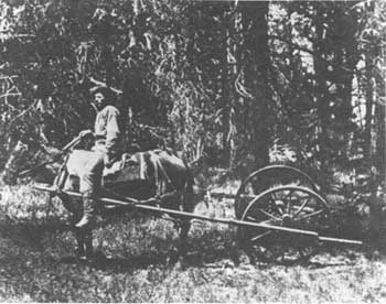
| This odometer was used in one of the Hayden Surveys of Yellowstone. The Raynolds Survey of 1860 used a similar odometer in Jackson Hole, until the wheels were lost in a river crossing. US. Geological Survey, William Henry Jackson #1290 |
Doane and his men moved on into the Snake River Canyon, where the boat capsized, "dancing end over end in the swift cold current." On December 18, they reached Keenan City, a mining camp located in the Snake River Range. Doane's weight had dropped from a robust 190 pounds to a mere 126 pounds. The rest were in similar condition. They arrived at Fort Hall, Idaho, on January 3, 1877. Doane planned to secure a new outfit and press on down the Snake River, but his commanding officer ordered him "with his escort to rejoin his proper station Fort Ellis, as soon as practicable." [23]
Doane later reported that his commander, Major Brisbin, had disapproved of the entire project from the outset. The fact that Doane had circumvented Brisbin to secure permission for the expedition may have contributed to his recall.
In retrospect, Doane's expedition exhibited poor planning and timing. [24] The goal of exploring the Snake River from Yellowstone Lake to the Columbia River was very general. Why the army required such a survey is unknown. Further, making the trip in winter was foolish. Doane recalled that the old trapper, John Pierce, "was evidently completely puzzled as to what motive could have induced us to make such a trip in such a way and at such a season." [25] Doane and his fellow cavalrymen were lucky to survive the trip. He lost his journal when the boat capsized in the Snake River Canyon. He wrote his narrative much later, using Sergeant Server's cryptic journal. Regardless, it remains one of the most interesting records of exploration in Jackson Hole; the foolishness of the trip adds to its appeal.
Expeditions such as Doane's did nothing to promote military surveys, which conflicted increasingly with civilian surveys after 1865. The U.S. Geological Survey of the Territories was formed in 1869. This Interior Department bureau competed with the military and, through this bureau, the civilian scientist replaced the soldier-explorer in western surveys. Ferdinand Vandiveer Hayden, a veteran of Raynolds's 1860 survey, became one of the premier civilian explorers after the Civil War. Hayden had launched new surveys in 1867, eventually reporting directly to the Secretary of the Interior in 1869. As his influence grew, surveys received increased funding from Congress. [26]
In 1871, Congress appropriated $40,000 for a survey of the Yellowstone country, which was very generous for a notably stingy group of solons. Hayden spent the season in Yellowstone accompanied by a party that included William Henry Jackson, the pioneer photographer, and Thomas Moran, the landscape artist. Hayden's flair for publicity, aided by Jackson's photographs and Moran's artwork, contributed to the creation of Yellowstone National Park in 1872.
Hayden returned to the Yellowstone country to explore the sources of the Snake and Missouri Rivers in 1872. This survey was significant for several reasons. Most important, it established Hayden's dominance in the field of exploration for several years, overshadowing both civilian and military competition. Further, as Hayden matured as a survey leader after the Civil War, he recognized the importance of public relations in securing funding. He cultivated conscientiously the support of congressmen, railroad magnates, soldiers, and westerners. As a result, his interest shifted from the purely scientific to general inventories of the West's exploitable resources. His reports remained truthful, but tended to emphasize the positive, which delighted Western boosters.
As a result, Hayden's surveys were well funded for the next few years. The 1872 survey employed the largest field crew yet; 61 men were divided into two divisions. Hayden led one group into Yellowstone, while James Stevenson led the other party into the Snake River country, which included Teton Basin and Jackson Hole. Snake River Division members included the following people: Professor Frank Bradley, chief geologist; Gustavus Bechler, topographer; John Merle Coulter, botanist; C. Hart Merriam, ornithologist; and William H. Jackson, photographer. The Hayden Surveys provided experience and exposure for men who would distinguish themselves in their fields. The 1872 survey was notable also for the number of political appointees included in the expedition; the packers and guides referred to them as "pilgrims." While some carried their weight, others did not. Hayden, mindful of future funding, cultivated the favor of politicians by accepting these pilgrims. [27]
The Snake River Division left Ogden, Utah, on June 24, 1872, and reached Fort Hall, Idaho, on July 3. From Fort Hall, Stevenson led the division into Teton Basin, formerly called Pierre's Hole. They spent two weeks surveying the basin and mapping the Teton Range. Two notable events occurred: N. P. Langford and James Stevenson made the first ascent of the Grand Teton, and William H. Jackson took the first photographs of the Grand, Middle and South Teton. Hayden reported the ascent by Langford and Stevenson in the introduction of his 1872 report, stating "so far as we can ascertain they are the only white men that ever reached its summit." Langford also wrote an account of the climb for Scribner's Monthly. [28] Their claim went unchallenged until 1898, when Franklin Spalding, Jack Shive, Frank Petersen, and William O. Owen reached the summit. Owen challenged Langford's claim for reasons discussed in another chapter of this study, launching a controversy that still flares up periodically today.
|
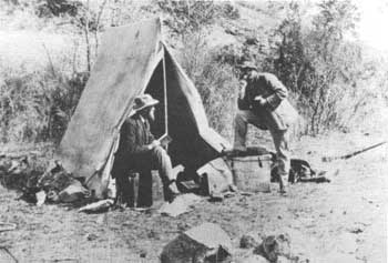
| Ferdinand V. Hayden (left) and William Paris in camp, 1872. William Henry Jackson Photograph, National Park Service |
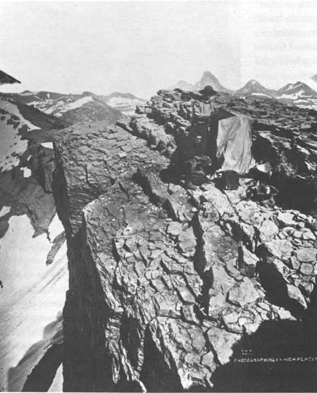
Meanwhile, Jackson set out from the camp on Teton Creek to find a suitable vantage point to photograph the Tetons. He recalled that "this side trip to the Tetons was really secondary to the main object of the expedition, but by this time Yellowstone had lost something of its novelty, and the Tetons, never before photographed, now became of the first importance, so far as I was concerned." [29] Jackson was accompanied by his assistant, Charley Campbell, John Merle Coulter, the botanist, P J. Beveridge, and a packer named Aleck. They ascended Table Mountain situated to the west of the three Tetons. The mules carried food and camp gear, while Jackson's mule, "Old Molly," hauled his precious photographic equipment. They set up camp at tree line, spent three days exploring the area, and sought a good vantage point for photographic work. While making their way to the summit of Table Mountain, they found their passage blocked by a wall of rock. "On one side was a sheer precipice, but on the other a ledge supported a bank of hard snow, 'which offered a passage around the wall.' " The snowbank formed a dangerous angle, hanging over a sheer drop of several hundred feet. Deciding the risk was worth the view, they first packed a trail on the snow, then carefully guided their saddle and pack animals across the snowbank. Jackson spent most of the day making 8 x 10-inch, 11 x 14-inch, and stereoscopic negatives. One exposure shows young Jackson kneeling beside his dark tent near an abrupt precipice with the Teton peaks looming on the horizon. He arranged the photograph, while Aleck the packer made the exposure. Jackson's photographs of the Grand Teton are among the most famous of his thousands of remarkable images of the American West. The Grand Teton was revealed to Americans for the first time. After ten days on their own, Jackson's party returned to the main camp. [30]
|
| Photographing in High Places by William Henry Jackson, 1872. Jackson and an assistant ascended Table Mountain to photograph the surrounding area during the Hayden survey of 1872. His photographs were the first ever made of the Tetons. US. Geological Survey, William Henry Jackson #172 |
The Snake River Division made their way north toward Yellowstone, meeting Hayden's division in Yellowstone in mid-August. A portion of Stevenson's division set out to explore the headwaters of the Snake River and Jackson Hole in early September. They surveyed about 40 small streams that make up the headwaters of the Snake, then moved down the river into Jackson Hole. W. H. Jackson did not accompany Stevenson on this portion of the survey, thus no photographs were taken of the Teton Range from the east. [31]
On September 19, the division reached the inlet of Jackson Lake, flanked by trees cloaked in the yellows and pale reds of autumn. Geologist Frank Bradley described the scene: "The Teton Range had been before us for many days as a prominent feature of the landscape, but now its peaks stood up as the features of main interest, bounding the valley on the west with a series of roof-like ridges and pointed peaks, well besprinkled with patches of snow." [32] At their camp, less than a mile above the inlet of the lake, Beaver Dick Leigh, the popular guide, rejoined them. One member of the party, Robert Adams, took the first soundings on Jackson Lake, securing a reading of 258 feet in depth before a driving squall forced him off the lake. Adams's canoe trip was the first record of boating on Jackson Lake.
On September 21, the Snake River Division moved south along the eastern shore of the lake, camping at a location possibly east of Sargent's Bay. The next day they reached the outlet of Jackson Lake and followed the course of the Snake River to the Oxbow Bend area. They camped here for two days.
Topographer Gustavus Bechler followed the Buffalo Fork nearly to its headwaters. Meanwhile, Frank Bradley possibly ascended Lozier Hill rather than Signal Mountain for he described Jackson Hole "from the top of the butte at the mouth of the lake." From the summit, Bradley observed that the Snake River had abandoned its southern channel for its present course in the remote past. His description suggests Signal Mountain, but the map of his route through Jackson Hole indicates Lozier Hill. On September 24, Stevenson's division forded the Snake River below Oxbow Bend. Here the party split up, one group following the river along its west bank, while the other group traveled in a southwesterly course to the glacial lakes at the base of the Teton Range. At String Lake, they camped from September 25 to 28. [33]
|
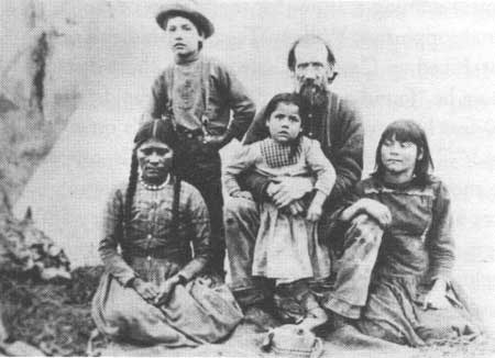
| "Beaver Dick" Leigh and his family at Blackfoot, Idaho. Leigh was the guide for the 1872 Hayden Survey; Jenny Lake was named for Leigh's wife. Jackson Hole Historical Society and Museum |
In his report, Frank Bradley left a record of a landscape that remains remarkably unchanged today. The survey team traveled over broad sagebrush-covered plains, interspersed with isolated ponds. They crossed a narrow belt of spruces, then descended into the old channel of the Snake River. Bradley described clearly the Potholes and Burned Ridge, a forest-mantled glacial moraine. Rudolph Hering, an assistant topographer, prepared the first cross-section of the valley, based on elevation statistics. Bradley's narrative is the first scientific description of Jackson Hole. The survey team named the lakes in honor of their guide, Beaver Dick Leigh, and his wife Jenny, hence the names Leigh and Jenny Lakes. This constituted a refreshing departure from the Hayden precedent of naming features for themselves or congressional supporters. William Taggart, Bradley's assistant, hiked up Cascade Canyon for a short distance, where he "found a cluster of falls and rapids about 250 feet high with lofty precipitous walls on either hand." [34] Taggart had visited Hidden Falls, one of the most beautiful places in the park. Predicting lakes at the mouths of other canyons, Bradley and Taggart located two, which they named Taggart and Phelps Lakes. (Beaver Dick Leigh informed them that a hunter named George Phelps had first seen and reported the southern lake; they named it in his honor.) Bradley Lake appears on the map, but it is not mentioned in Bradley's report.
|
Snake River Division Camps in Jackson Hole | ||
| Dates | Site | Location |
| Sept. 19-22, 1872 | Inlet of Jackson's Hole | Possibly Lizard Creek |
| Sept. 21-22, 1872 | Jackson's Lake | Unknown |
| Sept. 22-25, 1872 | Outlet of Jackson's Hole | Oxbow Bend area |
| Sept. 25-28, 1872 | Eastern foot of Mount Hayden between glacier lakes | String Lake |
| Sept. 28-30, 1872 | Snake River, at junction with creek from glacier lakes | Cottonwood Creek |
| Sept. 30-Oct. 1, 1872 | Snake River, below mouth of Gros Ventre Creek | Opposite north end of West Gros Ventre Butte |
| Oct. 1-2, 1872 | East of Teton Pass | |
On September 28, they followed Cottonwood Creek to its junction with the Snake River, just above present-day Moose, Wyoming. They camped in this area until September 30. While here, Gustavus Bechler forded the river and ascended "a high rocky butte" which they named Upper Gros Ventre Butte. This conspicuous summit is Blacktail Butte. Based on Bechler's field notes, an illustrator produced an excellent drawing of the Teton Range from Blacktail Butte. This may be the first artistic illustration of the Teton Range. [35] Bradley wrote that this area consisted of a series of terraces dominated by sagebrush. They saw antelope in Jackson Hole for the first time. Noticing the effects of fire, Bradley wrote that around Blacktail Butte, "large areas of the sage had been burned off, and the grasses had grown up densely, forming fine pasturage."
The Snake River Division moved south along the west side of the river on September 30, camping about a mile below the mouth of the Gros Ventre River, across from the South Gros Ventre Buttes. The next day they camped at the foot of Teton Pass. On October 2, the Snake River Division split, one party crossing Teton Pass, while the other group followed the course of the Snake River into Idaho. Stevenson's Snake River Division ended their season's work at Fort Hall on October 11, 1872. [36]
The Hayden Surveys returned to Jackson Hole in 1877 and 1878, but neither proved historically as significant as the 1872 survey. Later surveys examined the area to develop a detailed map and a systematic geological survey of Idaho, Montana, and Wyoming. [37] Gustavus Bechler led the Teton Division in 1877. Hayden directed Bechler to map the sources of the Snake River. Bechler managed to survey approximately 6,000 square miles before Chief Joseph's retreating Nez Perces forced his division to suspend work in the fall. [38]
Orestes St. John accompanied the Teton Division as staff geologist, entering the valley in August 1877. St. John noted in his letter of transmittal that his fieldwork supplemented the work of Bradley and Taggart. But, in doing so, he added more detailed information about the Teton Range and Jackson Hole. St. John examined the central Teton Range confirming the granitic and metamorphic composition of the peaks. He investigated the vast morainal deposits in Jackson Hole and speculated that while glaciation explained the canyons scoring the Tetons and moraines at their base, the "potency of simple-acting atmospheric influences" was the cause of water-worn debris in the valley. [39]
Making more general observations, St. John found the soil in the valley fertile and that there was plenty of water, but concluded that latitude, altitude, and a short growing season would prohibit the development of agriculture. He believed the valley was more suited to grazing. Further, the variety and abundance of wildlife impressed him; noting that "at seasons the woods are stocked with game; elk, deer, antelope, and bears abound, while in the forest two or three kinds of grouse are found, and the streams afford abundance of large delicious trout." [40] In the 1880s and 1890s, Jackson Hole would become famous for its hunting and fishing. Finally, while investigating the mountains in the vicinity of Togwotee Pass, St. John reported "immense columns of smoke from forest conflagrations rose high in the air, in places blotting out the view of distant mountains." [41]
In 1878, the last Hayden Survey took the field, continuing the work of 1877. Hayden broke the survey into four divisions. F. A. Clark led the Wind River Division, which completed the topographical work that included areas adjacent to Jackson Hole. A. D. Wilson completed the primary triangulations of the entire survey area, begun in 1877. The Upper Saddle of the Grand Teton was an important station. William H. Jackson rejoined Hayden after an absence of two years, leading a photographic division through Jackson Hole. [42]
Wilson came to Pierre's Hole in 1878, after water-swollen rivers had prevented entry in 1877. With Jackson's team, they detrained at Point of Rocks, Wyoming, and set out for the Wind River Mountains. W. H. Holmes, a topographer with an aptitude for drawing accurate sketches of the landscape, traveled with Jackson's party. Hayden himself accompanied the group. They traveled to the head of the Hoback River, then followed the trapper-Indian trail into Jackson Hole. Jackson found the Hoback's scenery attractive, "but it had some serious problems in the long steep slides that crossed it frequently. These made precarious footing for riding and pack animals." One mule stumbled and rolled some 200 feet down a slope, but escaped unhurt. At Little Gros Ventre Creek (Flat Creek) Wilson and Jackson parted company. Wilson's party crossed Teton Pass into Pierre's Hole, while Jackson's division followed the course of the Snake River into Yellowstone Park.
Wilson intended to use the Grand Teton as a primary triangulation station, which required an ascent of that peak. The survey team followed Teton Creek into the gentler western portion of the range, where they set up a base camp. Accompanied by his assistant, A. C. Ladd and his guide, Harry Yount, Wilson set out to climb the Grand Teton in August. The small party made their way up the plateau (Table Mountain) west of the Tetons, a single line of three men on horse trailed by one pack mule. They reached the plateau with no trouble, but found their path to the Grand Teton blocked "by a deep and very abrupt canon [sic]," the South Fork of Cascade Canyon. Even though it was August, heavy snow banks blocked their passage down the steep slopes into the canyon. Wilson and his companions descended from tree to a basin with enough grass and timber to set up camp. Heavy rain and snow forced them to camp for two or three days. Since they had only brought food for three of four days, Wilson became concerned about the weather. [43]
While waiting for the weather to improve, Wilson climbed to a ridge southeast of camp to scout the approaches to the Grand Teton. It was here that he spotted four grizzly bears on a snowbank below the ridge, "playing 'hide and go seek' among the crevasses." Wilson stole into a hidden position in the rocks, apparently undetected by the bears. Then he "fired three or four shots at them, killing two of them; but finding that I had but one cartridge left and two bears, I thought discretion the better part of valor, and . . . 'lit out' for camp!" There is no record that Wilson returned to assure himself that the bears were dead or collect any part of the carcasses for scientific purposes. [44]
On August 20, the weather cleared, allowing Wilson, Ladd, and Yount to try an ascent. They first crossed a pass in the light of a full moon, possibly Hurricane Pass, into the South Fork of Cascade Canyon. They picked their way over a spur, before beginning their climb of the Grand. Scrambling up a slide of loose rock on the southwest side of the mountain, they finally reached the Lower Saddle between the Grand and Middle Teton after an hour's hard work. The group reached the Upper Saddle after a rugged climb. At this point, he could see no way to scale the last several hundred feet to the summit. Wilson expressed his disappointment, recalling "for the first time, after climbing hundreds of peaks during my twelve years of experience, I was compelled to give up reaching the summit." He noted the same circular enclosure discovered by Langford and Stevenson in 1872, along with a pile of rocks supporting an upright stick presumably built by a white man. [45] Wilson and Ladd set up their instruments and recorded their measurements from the Upper Saddle. They returned to the main camp and set out for Yellowstone on the next day. The work of Wilson's primary triangulation survey covered 28,000 square miles. His survey established relative locations between prominent topographical features that were critical to accurate mapping.
Meanwhile, the photographic team traveled north through Jackson Hole. Hayden reported that Jackson photographed "several magnificant views" of the Teton Range from the Jackson Lake area. [46] These are the first known photographs taken from Jackson Hole. Jackson was not so ebullient as Hayden. In his memoirs, he recalled that few negatives were made in the valley, because of "a smoky haziness that filled the air." From a highpoint on Signal Mountain, he made a very credible negative of the Teton Range, framing the Grand Teton on the left and Mount Moran on the right. The haze of smoke from forest fires is clearly visible, looming over Jackson Lake and the valley. In his autobiography, Jackson does not mention photographing the Tetons, writing only that they passed through "the beautiful basin that has the distressing name of Jackson's Hole." [47]
|
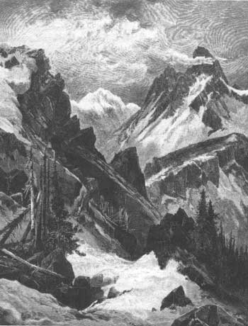
| Artist Thomas Moran sketched this early view of Mount Hayden (the Grand Teton) and Mount Moran from Pierre's Hole in 1879. Moran never actually visited Jackson Hole. Jackson Hole Historical Society and Museum |
The photographic survey rode north into Yellowstone. Jackson made 45 8 x 10-inch negatives and 110 negatives of 5 x 8 inches, forsaking quantity to produce a selection of quality prints. In September, the party traveled along the Upper Yellowstone River, crossing Two Ocean Pass into the Buffalo Fork drainage. From the vicinity of Togwotee Pass area, Jackson photographed the Teton Range for the first time, although he did not consider the photographs especially significant. While on the Upper Yellowstone, he stalked and killed a "large silvertip" grizzly bear, which he believed a high point of the trip. [48]
The 1878 survey was the last directed by Hayden, for in 1879, Congress created the U.S. Geological Survey, which dissolved the three civilian surveys then in existence. This included Hayden's Geological Survey of the Territories. He had fallen victim to the intense rivalries between explorers and bureaucracies. The last Hayden Survey ended nearly a century of discovery in the American West. In 1803, the land west of the Mississippi River was a great void on maps. The interior beyond the Spanish settlements in New Mexico and California and west of the frontier on the Mississippi River was unknown to transplanted Europeans. By 1878, explorers, scientists, and surveyors had changed that; they had explored, mapped, and described the American West. The age of discovery was over.
This frontier is significant for several reasons. First, using the knowledge of the fur trapper, explorers opened the West for settlement by mapping and surveying transportation routes. Second, surveyors had prepared accurate and detailed maps by the end of the 1870s. Third, these frontiersmen had produced voluminous reports covering a wide range of topics. Fourth, early explorers such as Fremont guaranteed a United States that would span the continent from coast to coast. Fifth, surveyors and scientists identified many of the problems in administering vast public lands. For example, surveyors argued convincingly, though not with much success, for the systematic classification of western lands. John Wesley Powell believed that political entities in the West should be based on hydrological features or river drainages. Sixth, these frontiersmen explored for the sake of knowledge itself. Scientists and surveyors saw the West as a vast natural laboratory. Resources of the West were exploited, but for their secrets rather than financial gain. Significant discoveries were made in the fields of geology, botany, zoology, paleontology, and ethnology-archeology. It became a golden era in the history of science. Seventh, because of this frontier, science and land management became institutionalized in new federal agencies and new specialties in science. Finally, explorers, surveyors, and scientists revealed the West to Americans through their reports, maps, and illustrations. And in revealing that wondrous land, they helped shape the self-image of Americans. If Americans had no great architectural monuments or long cultural traditions, they could take pride in a vast and splendid empire of deserts and forests and plains and mountains, filled with plants, animals, and natives. [49]
Six surveys associated with this frontier visited Jackson Hole. Capt. W. F. Raynolds came first in 1860. Through this expedition, the frontier of the mountain man, explorer, and scientist merged. Jim Bridger passed on his knowledge of the West to Raynolds and F. V. Hayden. For the first time, specimens were collected, as Hayden studied the geology of the Gros Ventre-southern Jackson Hole area through the eyes of a scientist. Further, Raynolds concluded in his report that the country around the Teton Range was too rugged for a railroad. Finally, Raynolds gave Union Pass its name. It was 13 years before the next survey party entered Jackson Hole, led by Capt. William A. Jones of the Army Corps of Engineers. Capt. Jones's "discovery" and naming of Togwotee Pass may be this expedition's most significant legacy to Jackson Hole.
Surveys, although important sources for historians, did not always prove fruitful. Lt. Gustavus Doane's trip in 1876 accomplished very little. Only the courage and campaign experience of Doane and his cavalrymen, aided by a generous pinch of luck, averted a disaster. Yet, Doane's narrative is arguably the most entertaining of the survey records. Near today's park headquarters at Moose, Wyoming, Doane and his troopers choked down horseflesh that tasted like a saddle blanket smells. Yet, Doane was irrepressible. Even after the ordeal in Jackson Hole, he was ready to press on down the Snake River from Fort Hall, when his superior recalled him to Fort Ellis. Doane's folly points out that exploration was an adventure as much as it was measuring elevations and collecting rock and plant specimens.
The 1872, 1877, and 1878 Hayden Surveys, particularly the 1872 expedition, were the most significant to the history of Jackson Hole, especially the 1872 survey. The 1872 survey produced a generally accurate map of the Teton Range and surrounding region though flawed in detail. Langford and Stevenson claimed the first successful ascent of the Grand Teton, while Jackson took the first photographs of the Grand Teton and Teton Range. In Jackson Hole, scientists evaluated the natural resources in detail for the first time. Frank Bradley and W. R. Taggart reconnoitered the geologic features of the valley, building on Hayden's work in 1860 and beginning a fine tradition of geologic study that goes on today. John Merle Coulter, the prominent botanist, accompanied Jackson on his excursion up Table Mountain, where he undoubtedly examined and collected alpine plants. Coulter collected around 1,200 plant specimens; the list in the report totals 34 pages, a significant number being found in the Snake River Valley and Teton Range. C. Hart Merriam collected a significant number of bird skins, nests, animal skins, and skulls. A representative number came from the "Snake River, Wyo." He collected one specimen of rabbit that he thought was a new species. Called Baird's rabbit, it was actually a snowshoe hare. Frank Bradley, impressed by the scenery in Teton Basin, predicted a bright future for tourism when railroads reached the area. Robert Hering reported a feasible railroad route from the Central Pacific line in Utah through Idaho and over Targhee Pass to Montana. He also located a possible wagon or rail grade north of the Teton Range through the Falls River-Beulah Lake country. [50]
But perhaps the most significant legacy of the Hayden Surveys is the place names of topographic features in the valley. The Snake River Division named a number of peaks and lakes in 1872. Some failed to survive such as North Gros Ventre Butte, known as Blacktail Butte today. They renamed the Grand Teton as Mount Hayden, in honor of their mentor, but it failed to stick. They gave Mount Moran, the prominent peak west of Jackson Lake, and Mount Leidy, east of the valley, their names even though neither man ever visited Jackson Hole. In 1879, Thomas Moran visited Teton Basin and saw the peak named for him from the west side of the range. [51] The surveyors named the glacial lakes at the base of the range; Phelps, Taggart, Bradley, Jenny, and Leigh Lakes. [52] Mount St. John was named later in honor of Oreste St. John, the field geologist with the surveys in 1877 and 1878.
Other surveys would follow, but their significance was less important. By the time, President Chester A. Arthur traveled through Jackson Hole in 1883 with a large entourage of guides, Indians, cavalrymen, packers, and political cronies, the avowed purpose was recreation rather than exploration. A year after Arthur's tour, the first settlers entered Jackson Hole, marking a new era in the valley's history. [53]
Notes
1. Meriwether Lewis, The Expedition of Lewis and Clark, ed. William H. Goetzmann and Archibald Hanna, 1814 edition, unabridged in 3 vols. (Philadelphia: J.B. Lippincott Co., 1961), l:xix-xxvi; and William H. Goetzmann, Exploration and Empire: the Explorer and Scientist in the Winning of the West (New York: Alfred A. Knopf, 1966; New York: Vintage Books, 1972), pp. 3-8.
2. Goetzmann, Exploration and Empire, pp. 242-244 and 249; and John Charles Fremont, The Expeditions of John Charles Fremont, Donald Jackson and Mary Lee Spence, ed., 2 vols. (Urbana, IL: University of Illinois Press, 1970), 1:271.
3. Billington, Westward Expansion, pp. 553-556; and Goetzmann, Exploration and Empire, pp. 265-266.
4. Goetzmann, Exploration and Empire, pp. 265-302.
5. David J. Saylor, Jackson Hole, pp. 97-99; and Goetzmann, Exploration and Empire, p. 328.
6. Saylor, Jackson Hole, p. 97.
7. Goetzmann, Exploration and Empire, p. 303.
8. J. Cecil Alter, James Bridger, Trapper, Frontiersman, Scout and Guide, a Historical Narrative (Salt Lake City, UT: Shepard Book Company, 1925), p. 337. This material is taken from Capt. W.F. Raynolds's journal.
13. Ibid., p. 362; and Saylor, Jackson Hole, p. 97.
14. Goetzmann, Exploration and Empire, pp. 409-412 (Goetzmann believes the accomplishments of the Jones survey have been underrated); Saylor, Jackson Hole, p. 109; and Aubrey L. Haines, The Yellowstone Story: A History of our First National Park, 2 vols. (Yellowstone National Park, WY: Yellowstone Library and Museum Association in cooperation with Colorado Associated University Press, 1977), 1:201-203.
15. G.C. Doane, "Expedition of 1876-1877," unpublished manuscript typed from original, Grand Teton National Park Library, pp. 1-7; and Orrin H. and Lorraine J. Bonney, Battledrums and Geysers; the Life and Journals of Lt. Gustavus Cheney Doan (Chicago: Sage Books, 1970).
16. Doane, "Expedition," pp. 1-7.
19. Ibid., p. 23; and Bonney, Battledrums and Geysers, p. 516.
20. Doane, "Expedition," p. 24.
24. Saylor, Jackson Hole, p. 110; Bonney, Battledrums and Geysers; and Merlin K. Ports, "The Doane Expedition of 1876-1877," Campfire Tales of Jackson Hole (Moose, WY: Grand Teton Natural History Association, 1970), pp. 20-37.
25. Doane, "Expedition," p. 27.
26. Goetzmann, Exploration and Empire, pp. 489-490.
27. Richard A. Bartlett, Great Surveys of the American West (Norman: University of Oklahoma Press, 1962), pp. 59-73; Goetzmann, Exploration and Empire, pp. 511-515; and F.V. Hayden to Secretary of the Interior, C. Delano, March 10, 1873, Sixth Annual Report of the US. Geological Survey of the Territories . . .for 1872 (Washington, D.C.: Government Printing Office, 1873), pp. 1-10.
28. Hayden to Secretary of the Interior, March 10, 1873, Sixth Annual Report, p. 2; and N. P. Langford, "The Ascent of Mount Hayden," Scribner's Monthly 4 (June 1873):129-137.
29. William H. Jackson, The Pioneer Photographer: Rocky Mountain Adventures with a Camera, in collaboration with Howard R. Driggs (Yonkers-on-Hudson, NY: World Book Co., 1929), p. 123.
31. Frank H. Bradley, "'Report," Sixth Annual Report, pp. 250-267. Camps of the Snake River Division are listed on p. 814.
33. Signal Mountain is closer to the outlet of Jackson Lake than Lozier Hill, but the latter hill is shown on the map "Sources of the Snake River." Signal Mountain does not appear on the map.
34. Bradley, "Report," p. 264.
35. Ibid., pp. 261-262, Figure 50.
36. Hayden to Secretary of the Interior, March 10, 1873, Sixth Annual Report, pp. 1-10; and Bradley, "Report," pp. 265-271.
37. Bartlett, Great Surveys, pp. 72-73.
38. F. V. Hayden to Secretary of the Interior, December 1, 1878, Eleventh Annual Report of the United States Geological and Geographical Survey . . .for the Year 1877 (Washington, D.C.: Government Printing Office, 1879), pp. ix-xvi.
39. St. John, "Report of Orestes St. John," Eleventh Annual Report, pp. 411-413 and 443-448.
42. F. V. Hayden to Secretary of the Interior, January 1, 1879, Twelfth Annual Report of the United States Geological and Geographical Survey . . .for the Year 1878, 2 vols. (Washington, D.C.: Government Printing Office, 1883), l:xiii-xviii.
43. Jackson, Pioneer Photographer, pp. 292-305; and A. D. Wilson, "Report on the Primary Triangulation of 1877 and 1878," Eleventh Annual Report, pp. 651-660. There is some confusion as to whether Hayden accompanied Jackson.
44. A. D. Wilson, "Report," Eleventh Annual Report, p. 657.
46. Hayden to Secretary of the Interior, January 1, 1879, Twelfth Annual Report, l:xvi.
47. Jackson, Pioneer Photographer, p. 296; and William Henry Jackson, Time Exposure: the Autobiography of William Henry Jackson (New York: G.P Putnam's Sons, 1940), p. 248.
48. Jackson, Pioneer Photographer, pp. 299-300; and Jackson, Time Exposure, pp. 249-250.
49. Goetzmann, Exploration and Empire, pp. 312, 527, 580, and 599-601; and Bartlett, Great Surveys.
50. Bartlett, Great Surveys, p. 73; Goetzmann, Exploration and Empire, pp. 511-515; Bradley, "Report," p. 223; and R. Hering to F. V. Hayden, Sixth Annual Report, pp. 92-95.
51. Thomas Moran Diary, 1878, Acc. #114 Cat. #1753, Grand Teton National Park Diary.
52. Goetzmann, Exploration and Empire, p. 512.
53. Saylor, Jackson Hole, pp. 113-116.
| <<< Previous | <<< Contents >>> | Next >>> |
grte/hrs/chap4.htm
Last Updated: 24-Jul-2004