|
Grand Teton
A Place Called Jackson Hole A Historic Resource Study of Grand Teton National Park |

|
CHAPTER 3:
The Fur Trappers
We descended the Gros vent fork to "Jacksons hole" about 20 mls. general course West. 28th We followed wis' fork thro the valley crossing several large streams coming in from the East. We then left the valley and followed the river about 5 mls thro. a piece of rough piney country and came to Jackson's. . . . We encamped at the outlet. . . .
—Osborne Russell, Journal of a Trapper
|
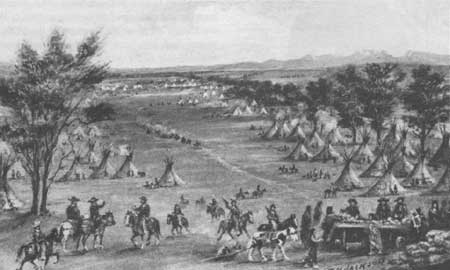
| "Green River Rendezvous," painted by William Henry Jackson. Rendezvous provided an opportunity for trappers to gather and trade news, stories, pelts, and supplies. The closest rendezvous to Jackson Hole was Pierre's Hole, west of the Teton Range. Jackson Hole Historical Society and Museum |
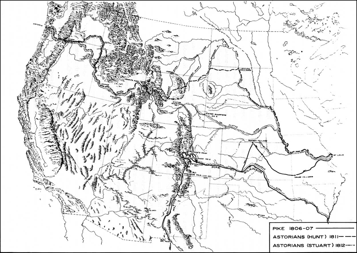
Trappers knew the Three Tetons and Jackson Hole well by the time Osborne Russell bivouacked at the outlet of Jackson Lake in 1836. [1] For a decade, mountain men had traversed the high passes into this valley. Almost 30 years had passed since John Colter set out on foot in 1807 from Fort Manuel, a fur-trading post at the junction of the Bighorn and Yellowstone Rivers, to become perhaps the first white person to enter Jackson Hole. The "Astorians "traveled through in 1811 and 1812. Unlike Colter, there is no doubt that Wilson Price Hunt and Robert Stuart led the Astorians through the valley, locating overland trails from St. Louis to the Columbia River. The Astorians, representatives of John Jacob Astor's American Fur Company, had ventured west to locate a trading post on the Columbia, just one step in Astor's grandiose dream to establish a fur trade empire from the Great Lakes to the Pacific Coast. The War of 1812 thwarted Astor's scheme, his partners at Astoria sold the post to Britain's North West Company before a British warship could take it. For the next ten years, the British went unchallenged in the Pacific Northwest, until Jedediah Smith, the great American explorer, turned up at Flathead Post on the Salmon River in 1824. As part of that same journey. Jed Smith had crossed South Pass from the east, leading American trappers to the rich trapping grounds that lay beyond the Continental Divide. For the next five years, an American company—the Rocky Mountain Fur Company—dominated the fur trade in the West, trapping fine beaver country at the headwaters of several great river systems.
|
| Furs had been a valuable commodity in Europe for centuries. In the eighteenth and nineteenth centuries, beaver pelts became particularly popular, and mountain men in America trapped the beaver to near extinction. Jackson Hole Historical Society and Museum |
There were four general centers of exploitation in the western fur trade: the British Northwest headquartered on the Columbia River, the Southwest centered at Taos and Santa Fe, the upper Missouri River and, finally, the South Pass area. Beneath the Tetons, trails intersected in Jackson Hole. Mountain men crossed significant passes en route to trapping grounds at the headwaters of the Green, Snake, Yellowstone, Three Forks of the Missouri, and Wind Rivers—all located within 100 air miles of Jackson Hole and the Teton Range. Thus, the Tetons were a major landmark for trappers, and the valley became the crossroads of the fur trade in the northern Rockies. [2]
The fur trappers frontier spanned four decades in the Trans-Mississippi West, beginning with the explorations of Lewis and Clark in 1804-1806 and ending with the last rendezvous held in 1840. The fur trade was intimately tied to European exploration and expansion in North America. The rise of the fur trade coincided with the rise of capitalism and nation-states in Europe. [3] Furs have been a valuable commodity for much of recorded history, being practical garments in the temperate climate of Europe. During the Middle Ages, fur clothing represented high fashion and high social status. Excessive trapping and hunting of fur-bearing animals in Western Europe led to serious shortages by the 1400s. Extremely high prices resulted, making fur garments available only to the rich. European merchants sought other sources to meet the demand, and a significant trade developed with Russia and eastern European countries. When Europeans began probing the coast of North America seeking a sea route to Asia, they initially failed to recognize its potential as a source of furs. [4] But, within ten years after Christopher Columbus's first voyage to the New World in 1492, Europeans began to appreciate North America's fur-bearing resources.
The first European fur traders in the New World were Spanish and Portuguese fishermen. They often traded with the Indians they encountered, exchanging manufactured trinkets for furs. Following Spain and Portugal, France and England explored the North American coast, seeking a Northwest Passage as well as gold and silver. In 1534, the French explorer Jacques Cartier traded with the Micmac Indians in what is now Canada, exchanging ironware for furs. After 1598, the fur trade expanded rapidly in North America. Colonization coincided with this development, serving as the vanguard of European expansion. Through trade with Indians and the establishment of trading posts in remote territory, the French and British competed for an empire. Imperial rivalry caused a series of wars that resulted in the expulsion of the French from Canada. [5] By the late eighteenth century, the British Hudson's Bay Company and North West Company had expanded as far west as the Mandan villages on the Missouri River.
Spain claimed the Louisiana Territory in the eighteenth century, although its hold was tenuous at best. Alarmed at the appearance of British traders on the Missouri River, Spain tried to use its fur trade to consolidate its hold on this vast territory. Spanish authorities offered the equivalent of $3,000 to the first trader to reach the Pacific coast. No one succeeded. However, Spain did establish trade with Indians on the central Missouri in the 1790s from the small town of St. Louis, which became the principal outfitting center for the western fur trade. From St. Louis, trappers and traders traveled three major routes: the Missouri River, the Platte River to South Pass (the Oregon Trail), and the Santa Fe Trail. [6]
After France acquired the Louisiana territory from Spain, Napoleon Bonaparte sold Louisiana to the United States in 1803. President Thomas Jefferson selected Meriwether Lewis and William Clark to lead an expedition up the Missouri River to the Pacific coast to explore these newly purchased lands and to locate a water route, if possible. The expedition, which departed from St. Louis in 1804, succeeded in spectacular fashion. Lewis and Clark returned to St. Louis in 1806, reporting a country rich in beaver, friendly Indians, and a transportation route up the Missouri River. This news generated a small stampede in 1807, as entrepreneurs prepared outfits to ascend the Missouri River. A trader named Manuel Lisa led the way. [7]
Leading a party of 42 trappers and voyagers, Lisa and his brigade manhandled a keelboat up the Missouri and Yellowstone Rivers. Lisa constructed a fort where the Bighorn River flows into the Yellowstone. For the next year, Lisa directed trapping and trading operations from Fort Manuel before returning to St. Louis with a fortune in furs and new wisdom. He concluded that only large trading companies could operate efficiently and profitably. Soliciting a group of St. Louis merchants, Lisa formed the Missouri Fur Company in 1809, the first of the large American fur trading companies to work the upper Missouri. [8]
While traveling up the Missouri in 1807, Lisa met John Colter, a veteran of the Lewis and Clark expedition. Colter was the prototypical mountain man. An experienced frontiersman, he honed his skills with the Lewis and Clark expedition. Both officers considered him a reliable man. [9] Colter had been discharged at the Mandan villages in 1806 at his request, after two trappers named Hancock and Dixon persuaded him to return to the Rockies. Hancock, Dixon, and Colter spent the next year trapping the Yellowstone River, perhaps wintering on Clark's Fork of the Yellowstone. Colter broke up the partnership and was canoeing down the Missouri in 1807 when he met Manuel Lisa. Again, the mountains beckoned, and for the next three years Colter worked for Lisa's Missouri Fur Company. [10]
|
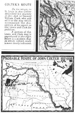
| The precise route of mountain man John Colter's 1807-08 journey through what is now northwestern Wyoming is not known, as he left no written account or map. The most probable route, derived from William Clark's map and contemporary accounts, indicates that he traveled through Jackson Hole and Yellowstone. National Park Service |
In the winter of 1807-1808, Lisa persuaded Colter to travel west to locate bands of Crow Indians and inform them of the trading post at the confluence of the Yellowstone and Bighorn Rivers. Colter completed a 500-mile trek in the middle of the winter of 1807-1808, possibly traveling through Jackson Hole. Henry Brackenridge left the only contemporary account, based on information obtained from Manuel Lisa. "He shortly after dispatched Coulter [sic], the hunter before mentioned, to bring some of the Indian nations to trade. This man, with a pack of thirty pounds weight, his gun and some ammunition, went upwards of 500 miles to the Crow nation; gave them information and proceeded from them to several other tribes." [11] Colter must have used snowshoes to make this journey in the winter, but there is no evidence to verify this conclusion. Some believe a Crow Indian accompanied him as a guide but, again, this is conjecture.
In 1810, William Clark produced a map of his route across the West. The map was published in 1814 in Paul Allen's History of the Expedition Under the Command of Lewis and Clark. A circular track appears on the map bearing the legend "Colters Route in 1807." The map shows Colter cutting a circular route around Lake Biddle, generally accepted as Jackson Lake, and Lake Eustis, widely believed to be Yellowstone Lake. Colter apparently met with Clark when he returned to St. Louis and gave information regarding his trip. It is not known whether Colter described the route or drew a rough map for Clark. (No journal or map by Colter is known to exist.) In any event, Clark's map provides the primary evidence that John Colter was the first white to enter Jackson Hole, Teton Basin (Pierre's Hole), and Yellowstone. But the map's topographical inaccuracies and imprecise scale make it impossible to determine Colter's route with absolute certainty. [12]
Other evidence helps establish Colter's route. The Missouri Historical Society possesses a manuscript map drawn by William Clark in 1808. Another Lewis and Clark veteran, George Drouillard, provided information for this map, which shows that Colter definitely reached the boiling springs at present-day Cody. Wyoming. No longer active, these geothermal features were the original Colter's Hell, rather than Yellowstone. [13] Yale University also possesses another map attributed to Clark that documents Colter's route. This manuscript map shows Colter crossing Teton Pass. The map also documents Wilson Price Hunt's Astorians route in 1810-1811, who exited Jackson Hole via Teton Pass. [14]
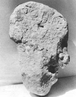
Artifacts provide other evidence. In 1931, William Beard and his son discovered a curious block of stone while clearing scrub timber from their land, five and one-half miles east of Tetonia, Idaho. The stone—a block of rhyolite lava 13-inches-high, eight-inches-wide, and four-inches-thick—was clearly carved into a crude face. One side bears the inscription "John Colter," the other "1808." Beard placed the stone on his porch, where it remained for two years. When neighbor A. C. Lyon learned of the stone, he traded a used pair of boots for it. In turn, Lyon donated it to Grand Teton National Park in 1934. Geologist Fritiof Fryxell, the park's first naturalist, concluded that the inscriptions had been exposed to weathering consistent with the 1808 date. Further inquiries also established that the Beards were not familiar with John Colter. Thus, Fryxell ruled out a hoax by the Beard family. [15]
|
| The head-shaped Colter Stone, which may have been carved by the famous mountain man, was discovered near Tetonia, Idaho, in 1931. One side reads, "John Colter," the other, "1808." The stone was found by a farmer plowing his field; he traded it for a pair of boots. Grand Teton National Park |
Yet doubts about the authenticity of the Colter Stone persist today. In recent years, writer W. C. Lawrence has alleged that A. C. Lyon planted the stone to curry favor with the National Park Service in order to secure the horse concession at Jenny Lake. [16] But this is an unlikely motive because Lyon acquired that concession in 1929, and the stone was discovered in 1931. (Lyon lost the concession for poor service in 1937.) [17] If the stone is not authentic, the more likely culprits were pranksters with the Hayden Surveys. The Colter Stone is one of six such stones found within a 25-mile radius in Teton basin. Two are obvious frauds; both bear the legend "Clark—1805," although Lewis and Clark did not pass through this area. Other stones were found at the possible site of Henry's Fort. The inscription reads, "GOD CAMP 1818 H.WELLS," "AL THE COOK BUT NOTHING TO COOK," and "FORT HENRY 1811 BY CAP HUNT." A retired Episcopal minister, J. Neilson Barry, studied this puzzle for years and concluded that "campfire doodlers" with the Hayden Surveys carved the inscription in 1877. Thus, rather than put it to rest, the Colter Stone fueled the controversy over John Colter's route. [18]
Another inscription was found on a tree on Coulter Creek in northern Teton Basin in the 1880s. The initials "JC" were carved under a large "X." Western writer Philip Ashton Rollins and two guides examined the carvings, and concluded they were about 80 years old. Around 1890, Yellowstone National Park employees cut the tree down and salvaged the portion bearing the initials. The log was to be placed in the park museum, but disappeared. Historian Aubrey Haines, who noted that there was no park museum in 1890, offered the theory that the lost inscriptions were for John Merle Coulter, a botanist with the Hayden Surveys and for whom Coulter Creek is named. [19] Haines also identified one place in Yellowstone where Colter with "reasonable assurance" passed through. This is where the Bannock Trail crosses the Yellowstone River. The Clark Map shows Colter's crossing with a note "Hot Spring Brimestone," where there are clear geothermal features such as tepid springs and fumaroles today. It is the only such crossing for miles in either direction. [20]
Even though the evidence remains inconclusive, the consensus of most historians is that John Colter did pass through Jackson Hole. Stallo Vinton, Colter's first biographer, believed Colter crossed Union Pass, then made his way into Jackson Hole via the Gros Ventre River. According to Vinton, Colter left Jackson Hole via Teton Pass, traveled north through Pierre's Hole, returned to the northern end of Jackson Hole via Conant Pass, and moved on to Yellowstone. Another theory is that Colter entered the valley and simply traveled north along the eastern shore of Jackson Lake. By contrast, J. Neilson Barry concluded that Colter crossed Two Ocean Pass and traveled northwest into Yellowstone, bypassing Jackson Hole. However, Colter's latest biographer, Burton Harris, believed Colter crossed Togwotee Pass into Jackson Hole, traveled south, and left via Teton Pass. Harris also theorized that Colter may have carved the Colter Stone while holing up to avoid unfriendly Indians, then fled south back across Teton Pass, and then traveled north past Jackson Lake into Yellowstone. David Saylor believed Colter took the Togwotee Pass, Jackson Hole, Teton Pass, Pierre's Hole, Conant Pass route. Aubrey Haines, in his biographical sketch of Colter, concluded that his route beyond Cody, Wyoming, is debatable, and questioned the authenticity of the Colter Stone. [21] Colter's exact route will probably never be determined. Did he enter Jackson Hole and Teton Basin? It remains an intriguing story, but one that will hardly alter the course of American history. John Colter left the West for good in 1810, moving near the present town of Dundee, Missouri. There, he settled down and married. He died of jaundice in 1812. [22]
Whether or not John Colter reached Jackson Hole, other trappers working for the Missouri Fur Company explored and trapped in Jackson Hole. In 1810, Andrew Henry, a partner in the company, led an expedition from Fort Manuel to the Three Forks of the Missouri River, the heart of Blackfeet and Gros Ventre territory. This formidable confederacy drove Henry's brigade out of this beaver-rich land into Pierre's Hole. The trappers retreated to the Henry's Fork of the Snake River, where they established a fort. From Henry's Fort, the rivers and streams of Jackson Hole were trapped for the first time in 1810-811. [23] In 1811, Henry disbanded the starving company, after a miserable winter at the first American post west of the Continental Divide. Three trappers, John Hoback, Edward Robinson, and Jacob Reznor headed east, crossing Teton Pass into Jackson Hole and exiting the valley via Togwotee Pass. [24] On the Missouri River, the veteran trappers met Wilson Price Hunt's brigade of Astorians bound for the Pacific Coast.
Hunt represented John Jacob Astor's American Fur Company, formed in 1806. Astor planned to establish a chain of forts from the Great Lakes to the mouth of the Columbia River. All furs would be shipped to the headquarters post on the Columbia and thence to the Orient. Astor not only hoped to realize large profits, but sought to drive the rival British Hudson's Bay Company and North West Company from the Pacific Northwest. He envisioned a worldwide commercial empire from St. Louis through the northern Rockies, to the mouth of the Columbia, and across the Pacific to China. In 1810, a group of Astor's traders began a journey by sea through the straits of Magellan to the mouth of the Columbia. There, in 1811, they began the construction of Astoria.
Wilson Price Hunt was one of the "Overland Astorians" who were traveling by land from St. Louis to meet up with their fellow trappers at Astoria. Upon meeting up with Hoback, Robinson, and Reznor, Hunt was impressed with their experience and persuaded them to serve as guides and hunters. Because of reports of hostile Indians on the upper Missouri, Hunt abandoned the river and traveled overland. Hoback and his partners led Hunt's party up the Wind River Valley and over Union Pass in September 1811. "The hunters who served as guides to the party in this part of their route assured Mr. Hunt that, by following up the Wind River, and crossing a single mountain ridge, he would come upon the headwaters of the Columbia." From Union Pass, the Astorians saw the Teton Range for the first time. "Here one of the guides paused, and, after considering the vast landscape attentively, pointed to three mountain peaks glistening with snow, which rose, he said above a fork of the Columbia river. They were hailed by travelers with that joy which a beacon on a seashore is hailed by mariners after a long and dangerous voyage." This is the first reference to the Tetons as the celebrated landmark of fur trappers. Washington Irving noted that by the 1830s these peaks were known as the Tetons, but "as they had been guiding points for many days to Mr. Hunt, he gave them the name of Pilot Knobs." [25]
The Astorians descended Union Pass to the upper waters of the Green River, then traveled to "a stream about 50 feet in width, which, Hoback, one of their guides, who had trapped about the neighborhood when in the service of Mr. Henry, recognized for one of the headwaters of the Columbia." This was Hoback River. Irving's description of the trail down the Hoback Canyon to the Snake River is unmistakable, it "meandered among rocks and precipices," forcing several dangerous river crossings. "Sometimes the banks advanced so close upon the river, that they were obliged to scramble up and down their tugged promontories, or to skirt along their bases where there was scarce a foothold." [26] Horses scrambled on the slopes, lost their footing, and sometimes fell. One horse rolled 200 feet into the river, load and all, but to everyone's amazement was unhurt.
After two days travel, the Astorians reached the confluence of the Hoback and Snake Rivers, where "their united waters swept off through the valley in one impetuous stream." [27] At what is known as Hoback Junction today, Hunt and his followers debated the possibility of abandoning their horses and traveling down the Snake River by dugout canoes. Hoback, Robinson, and Reznor were unfamiliar with this portion of the Mad River, as the Snake was known in 1811. Hunt dispatched three men down the Snake River Canyon to determine if it was navigable, while the others began constructing dugout canoes. Two Shoshone Indians entered their camp, saw what they were doing, and in sign language informed Hunt that it was not possible to canoe down the river. The scouts returned with a similar discouraging report. Therefore, Hunt decided to continue overland. In early October, the brigade broke camp, forded the Snake River, and trekked over Teton Pass. Guided by Hoback, Robinson, Reznor, and the two Shoshone, the expedition proceeded north through Pierre's Hole to Andrew Henry's abandoned post on the Henry's Fork of the Snake.
|
| Map showing the route of the Astorians, 1811-1812. (click on image for an enlargement in a new window) National Park Service (Great Explorers of the West, The National Survey of Historic Sites and Buildings) |
Promising trapping grounds interested Hunt nearly as much as locating a route to Oregon. While they camped at Hoback Junction, Hunt's party noticed favorable beaver sign in the area. Hunt detached four men to trap the upper waters of the Snake River, Alexander Carson, Louis St. Michel, Pierre Detaye, and Pierre Delaunay. They were to trap a load of pelts and then make their way to Astor's new post on the Columbia. At Henry's Fort, Hoback, Robinson, Reznor, and a man named Cass agreed to stay and trap the waters in the Henry's Fork area. A malcontent named Miller also remained. [28]
Hunt then led the remainder of the brigade to Astor's post on the Columbia. The Overland Astorians were the first Americans to cross the continent since Lewis and Clark. They pioneered a new route of which Union and Teton Passes were important links. Although the Overland Astorians were a commercial venture, their arrival on the Columbia challenged the British for sovereignty in the British Northwest. As such, they were a vanguard of American expansion.
In June 1812, Robert Stuart led a party of seven traders from Astoria to St. Louis carrying dispatches for John Jacob Astor. [29] Stuart's party followed the Port Neuf River from the Snake across a divide to the Bear River. There, they encountered a band of Crow Indians. Friendly trade degenerated into a confrontation when a Crow chief demanded that Stuart trade away his horse and some gunpowder. Stuart refused the first, but made a gift of 20 loads of gunpowder to avert violence. [30] To avoid further contact with the Crow, the Astorians traveled north from the Bear River to more familiar country. They eventually made their way down the Grey's River to its confluence with the Snake. On the morning of September 19, 1812, the same band of Indians rushed Stuart's camp, successfully stampeding and stealing all of the horses. The Crow chief "checked his horse, raised himself in the saddle, and clapping his hand on the most insulting part of his body, uttered some jeering words." Without horses, Stuart understood their vulnerability and refused to allow one of his men, Ben Jones, to fire at "the mark so fair and the insult so foul." [31] This incident occurred on McCoy Creek near present day Alpine Junction, Wyoming.
Now on foot, the returning Astorians constructed a raft and floated down the Snake for 100 miles. They abandoned the raft and crossed the Snake River Range into Pierre's Hole. The eight men stalked south, keeping to the foothills of Pierre's Hole to avoid Blackfeet. They crossed Teton Pass on October 7, 1812:
We continued on up the right hand Fork for 13 Miles S E by E to the summit of the Pilot Knob Mountain on which we found little or no snow—9 Miles same course brought us to Mad [Snake] River and in 2 more reached the opposite bank having crossed Five channels of from 30 to 60 yards wide each and from 1-1/2 to 3 feet water a very rapid current, and in every other respect of the same character as the part where we descended on the Rafts, with the exception that the valley is here several miles wide, and some of the Bottom upwards of a mile in breadth and thickly timbered with bitter Cottonwood and Pines. [32]
Stuart's party followed Hunt's route up the Hoback Canyon. Finding no food in Jackson Hole and on foot, starvation threatened them. So desperate was their plight, one of the party proposed casting lots, the loser becoming the evening meal. Stuart dissuaded the man with his rifle and restored order. They crossed the river and entered the Green River Valley, where through good fortune they killed an old bull buffalo, possibly saving their lives. Stuart and his comrades crossed South Pass from the west, following the Platte River east. They reached St. Louis in 1813. The Astorians "discovered" South Pass, but there is no evidence in Stuart's journal that he understood the significance of the pass. Also, they had traveled much of the route of the Oregon Trail, with the exception of their diversion into Jackson Hole. [33]
By the time Stuart and the seven members of the party reached St. Louis, Great Britain and the United States were at war. American Fur Company officials at Astoria sold the post to the British North West Company as a British warship was poised to seize it. Astor's grand plan was dashed. The War of 1812, the successful resistance of the Blackfeet to the encroachment of trappers in the Upper Missouri, and government indifference persuaded Americans to abandon the northern Rockies for the next decade. The British were winning the competition for dominion in the Pacific Northwest. [34]
Two licensed British companies competed against each other in western North America prior to 1821, the North West Company and the Hudson's Bay Company. The North West Company was very successful, largely because of its policy of trade with the Indians. This aggressive company established itself first in the Pacific Northwest. [35] In 1818, Donald MacKenzie led a party of North Westers from Fort Nez Perce on the Walla Walla River. A competent bourgeois, MacKenzie led 55 men on a long journey that may have included Jackson Hole. MacKenzie reported his route to Alexander Ross who, in turn, recorded it in his Fur Hunters of the Far West (1855). Ross's narrative provides the primary information on MacKenzie's route. Although historian Merrill Mattes recognized that Ross's description was "admittedly vague," he concluded that the available evidence "strongly suggested that MacKenzie did reach Jackson Hole in 1819." MacKenzie described his route as follows:
From this place [Boise] we advanced, suffering occasionally from alarms for twenty-five days, and then found ourselves in a rich field of beaver, in the country between the great south branch and the spanish waters, . . . I left my people at the end of four months. Then taking a circuitous route along the foot of the Rocky Mountains, a country extremely dreary during a winter voyage, I reached the headwaters of the great south branch. . . . [36]
Contemporary references to the Spanish River are generally understood to be the Green River. The "headwaters of the great south branch" may well be the upper Snake River in Jackson Hole. In his book, Ross described the Jackson Hole area, possibly based on MacKenzie's knowledge:
The most remarkable heights in any part of the great backbone of America are three elevated insular mountains, or peaks, which are seen at a distance of one hundred and fifty miles: the hunters very aptly designate them the Pilot Knobs (they are now generally known as the Three Paps or Tetons; and the source of the Great Snake River is in their neighbor-hood). . . . [37]
Also, Ross wrote a fantastic account of boiling springs and hot springs in the Yellowstone area, which could only come from a first-hand account. Mattes further pointed out that, since MacKenzie had been with the Astorians in 1811, he "would hardly miss the opportunity to investigate Upper Jackson Hole." [38] The Tetons and Pierre's Hole may have been named by Iroquois or French-Canadian trappers in MacKenzie's brigade. [39] Finally a tree carving was discovered in Yellowstone in 1880 (yes, another tree carving), which read "JOR Aug 19 1819." Could "JOR" have been a member of MacKenzie's North Westers? Mattes cautioned that no absolute proof of MacKenzie's trip exists, but that he passed through Jackson Hole is a reasonable conclusion. [40]
MacKenzie returned to Fort Nez Perce with a fortune in furs. Encouraged, other British brigades were dispatched to trap the waters of the Columbia and Snake Rivers. In addition to trapping beaver for profit, the British hoped to trap out an arc running roughly from the Snake River drainage through to northern California. They thus hoped to keep Americans out of the Oregon country, reasoning that American trappers, finding a swath of country devoid of beaver, would become discouraged and turn back. In 1821, the North West Company and Hudson's Bay Company merged, ending decades of fierce rivalry that had escalated to murder.
Two years later, in 1823, Finnan McDonald led the Hudson's Bay Company's annual expedition to the Snake River country. McDonald guided his brigade over the Salmon Mountains, then south to the Bear River. Stanley Morgan believed he traveled through Pierre's Hole, where the Three Tetons guided his route south. From the Bear River, McDonald may have crossed the mountains to the "Spanish River" or Green River. McDonald may have led his band of trappers north through the Hoback Canyon into Jackson Hole and on to Henry's Fork of the Snake. The British trappers crossed the Continental Divide again and traveled as far east as Great Falls, Montana. [41]
McDonald was a superb field leader. Not only did he lead his brigade the farthest east of any British bourgeois, challenging Americans on the Missouri River, he thrashed a band of Blackfeet near Lemhi Pass in Montana and returned to Spokane House with nearly 4,500 beaver pelts. It was a very successful season. But, when offered the command of the 1824 expedition to the Snake River, McDonald refused. "I got Safe home from the Snake cuntre . . . and when that Cuntre will see me agane the Beaver will have a Gould Skin." [42]
The appearance of British trappers on the upper Missouri did not go unchallenged. American fur traders prepared to reenter the beaver-rich upper Missouri after abandoning the field for a decade. In 1822, General William Ashley and Missouri Fur Company veteran Maj. Andrew Henry formed a new fur trading company. They recruited "one hundred young men to ascend the Missouri River to its source." [43] The men who enlisted were often little more than boys, and virtually all were mangeur de lard or "pork-eaters," a term for newcomers to the West. Yet, some became ideal mountain men. The Ashley-Henry employees list is a "Who's-Who" of the fur trappers frontier. On the list were Jim Bridger, Tom Fitzpatrick, Jed Smith, Etienne Provost, Bill and Milton Sublette, David E. Jackson, and Robert Campbell. [44]
Andrew Henry ascended the Missouri River by keelboat and established a fort at the mouth of the Yellowstone in 1822. Setbacks dogged the company in 1823. First, Henry led a party into Blackfeet country, where four of his men were killed. As in 1810, the Blackfeet confederacy drove Henry from the headwaters of the Missouri. Then, disaster struck on the Missouri. General Ashley led a party of green recruits up the river to join Henry. While camped at the Arikari villages, the Indians attacked Ashley's brigade, killing 13 trappers in a fierce fight. Ashley's brigade retreated down the river.
Taking a gamble, Ashley dispatched a party overland. Led by Jed Smith, the trappers traveled west from Fort Kiowa on the Missouri and wintered among the Crows in the Wind River Valley east of Jackson Hole. From the Crow, Smith learned of plentiful beaver across the mountains. He attempted to cross Union Pass, but snow blocked the way. Smith then followed the Popo-Agie River south and crossed South Pass from the east in February 1824. Smith's feat began a new chapter in the fur trappers' frontier. He reopened the abundant beaver streams west of the Continental Divide to American trappers. Just as important, the British faced their first serious competition since the Astorians in 1811. After trapping the Green River Basin, the brigade divided into four parties. Tom Fitzpatrick returned east with dispatches, rediscovering the Platte River route, which became the Oregon Trail. [45]
Smith traveled north with six companions. Based on Washington Hood's manuscript in the Missouri Historical Society Archives, Merrill Mattes and Harrison Dale believed Smith passed through Jackson Hole:
After striking the Colorado, or Green River, make up the stream toward its headwaters, as far as Horse creek, one of its tributaries, follow out this last mentioned stream to its source by a westerly course, across the main ridge in order to attain Jackson's Little Hole, at the headwaters of Jackson's fork [Hoback River]. Follow down Jackson's fork to its mouth and decline to the northward along Lewis's fork, passing through Jackson's Big Hole to about twelve miles beyond the Yellowstone pass [sic], crossing on the route a nameless beaver stream. Here the route passes due west over another prong of the ridge, a fraction worse than the former, followed until it has attained the headwaters of Pierre's Hole, crossing the Big Teton, the battleground of the Blacksmith's fork; ford Perre's fork eastward of the butte at its mouth and Lewis fork also, thence pass to the mouth of Lewis fork. [46]
Mattes believed that Smith traveled down the Hoback, called Jackson's Fork in this account, to Jackson's Big Hole and crossed the Teton Range via Conant Pass. The exact route is impossible to determine, because the place names in Hood's manuscript are confusing. Smith could have crossed Teton Pass, but the identity of Yellowstone Pass in the narrative is unknown. It became known as the route from the upper Snake into Yellowstone. [47] Jed Smith's biographer, Stanley Morgan, suggested that Smith did not pass through Jackson Hole at all, but traveled north via the Bear River, crossed the divide to the Blackfoot River, then followed it to the Snake River in present day Idaho. [48] Most historians believe that Jed Smith entered Jackson Hole in 1824, although whether he crossed Teton Pass or Conant Pass is uncertain. [49] At any rate, Smith went on to the Snake River in Idaho, where he met a group of Iroquois trappers employed by the Hudson's Bay Company. He then traveled to Flathead House, much to the discomfort of Alexander Ross, the bourgeois.
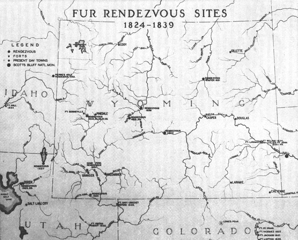
Smith's adventure in 1824 is significant for several reasons. A new overland route via the Platte River and South Pass was established, enabling trappers to trespass into Blackfeet country from the south. For the next 15 years, Jackson Hole served as an important crossroads for trappers. Trails intersected in the valley that led to important trapping grounds at the head of several great rivers. Americans challenged the British for control of the Pacific Northwest. Moreover, General William Ashley devised a different strategy for the Ashley-Henry fur-trading operation. He determined to rely on company trappers, rather than trade with Indians to obtain beaver plews. Instead of establishing trading posts, Ashley decided to bring goods and supplies to a predetermined location and gather the year's catch of beaver pelts. These gatherings became the famous "rendezvous." This system allowed trappers to stay in the field year-round, eliminating the need to haul their plews to forts on the Missouri River. The first rendezvous was held on the Henry's Fork of the Green River in 1825. [50]
Historian Merrill Mattes evaluated the evidence and believed four expeditions of the Ashley-Henry company passed through Jackson Hole between 1825 and 1828, but the lack of sound documentation makes it difficult to determine exact routes. [51] In 1825, Jim Bridger and Tom Fitzpatrick returned to the Rockies, after escorting Smith and Ashley to the Missouri River with the first year's catch of the "Rocky Mountain Fur Company." Leading 30 trappers, they may have crossed into Jackson Hole via Togwotee or Union Passes, then followed the Snake River into Yellowstone. They may have dispersed in Jackson Hole and trapped the valley intensively for the first time. Based on Jim Beckwourth's biography, William Sublette and other trappers traveled from the Blackfeet country to "Lewis' Fork on the Columbia" and "all moved on together for the head of the Green River" in 1826. The Teton Pass-Hoback trail would have been a logical route from the Lewis' Fork (Snake River) to the Green River. [52]
|
America and The West, 1790 to 1860 While 1,000 trappers at most waded icy streams setting traps, the vast majority of Americans preoccupied themselves with building a new nation. Jackson Hole and the Teton Range were forgotten after the demise of the trappers' frontier. Attention shifted to the Oregon Trail. Tom Fitzpatrick guided the first emigrant wagon train to Oregon in 1841. By 1846, 5,000 Americans had settled in Oregon's Willamette Valley. In 1847, Mormon pioneers located their own trail from Council Bluffs, Iowa, to the Salt Lake Valley. Both trails crossed South Pass. Then in 1848, workers discovered shiny flakes of gold in a millrace at Sutter's Mill in California, precipitating the greatest gold rush in American history. Meanwhile Americans fought a two-year war with Mexico beginning in 1846, wresting the Southwest from their southern neighbor. Most Americans remained east of the Appalachians, where colonists had won their independence from Great Britain in 1783. They faced a myriad of problems: How far would the reluctant revolution go toward reform? Should there be a national government? If so, how much power would be given the new national government? How much power would individual states possess? How would revenues be raised? Should there be a standing army and navy? What about the vast lands west of the Appalachians? How would they be incorporated into the United States? How could a nation founded on principles of equality and individual rights uphold the institution of slavery? Americans grappled with all of these issues and dealt with them, some more successfully than others. By 1790, the Constitution had been ratified and a new nation established. The nation grew rapidly from 1790 to 1860. The population increased from 3,929,000 in 1790, to 31,443,000 in 1860. In 1790, the Mississippi River was the western boundary of the United States. By 1860, the United States boundaries stretched from ocean to ocean, its territory more than doubled. Several developments were especially important to the West. After the War for Independence, the United States controlled vast tracts of public domain between the Appalachian Range and the Mississippi River. Two problems loomed across the Appalachians. Settlers squatted on lands, while speculators hatched grandiose schemes to buy and sell western lands for substantial profits. An orderly way had to be devised to transfer public domain to private ownership. The second problem centered on the ultimate political status of the public domain. American territories were really colonies, and the congress of the Confederation recognized that somehow equal political status must be granted, or they would separate just as the 13 colonies had with Great Britain. Congress enacted two landmark pieces of legislation to address these problems, the Ordinance of 1785, and the Ordinance of 1787. The Ordinance of 1785 divided federal lands into square townships, an area of 36 square miles. Each township was divided into 36 sections, each totaling one square mile or 640 acres. The government sold land at regularly scheduled auctions for a minimum price of $1 per acre. The government reserved one section to find schools. Not only did this act provide for an orderly transfer of land from public to private ownership, it brought much needed revenue to the nation's treasury. The Ordinance of 1787 established a process whereby territories could eventually become states rather than remain colonies. When the population of a territory reached 60,000, citizens could draft a state constitution and apply to Congress for statehood. Between 1791 and 1860, 20 new states entered the Union. Both ordinances set laws that lasted until the public domain closed in the twentieth century. The United States was an agrarian society, its people tied to the soil. Urbanization and industrialization began and accelerated between 1790 and 1860. Urban centers grew rapidly along the eastern seaboard as the nation's commerce developed. The Industrial Revolution began in the early nineteenth century with Slater's Mill in Rhode Island and the textile mills at Lowell, Massachusetts. New technology and industry had a profound impact on the West. Cities and industry demanded raw materials and foodstuffs; the West could fill some of those needs. Improved transportation in the form of steamships, canals, and later, railroads cut costs and shipping time dramatically, which promoted internal trade. The first settlers in the Old Northwest and Mississippi Valley were isolated and largely self sufficient, producing few exports. By 1860, as a result of improved transportation, American farmers produced most of the world's cotton and production of wheat for export increased substantially. Some Americans believed that the North American continent was a divine gift. As such, they perceived that Americans had not only the right, but the duty to settle, develop, and expand a continental republic. This belief became known as Manifest Destiny. The doctrine rationalized the growth of a continental empire and the displacement of native peoples. The Louisiana Purchase of 1803 initiated the expansion of the United States. Florida and the Gulf Coast were acquired in 1819. Americans rebelled and established a republic in Texas in 1836. Great Britain and the United Stated ended their joint occupation of Oregon in 1846, settling on the 49th parallel as a boundary. Texas joined the Union in 1845. Mexico ceded the entire Southwest and California as a result of the Mexican War. The Gadsden Purchase added a tract in the Southwest in 1853. The United States seemed blessed. Behind all of these issues and events loomed slavery. When a Dutch trader sold 20 blacks into slavery at Jamestown in 1619, he planted the seeds of bitterness and bloodshed. Slavery was permitted in all 13 colonies, but ideas generated by the American Revolution had significant implications for slavery. If all men were created equal, how could one human being own another? By 1804, all states north of Maryland had abolished slavery, while in the South, cotton and slavery flourished. As always, America remained a land of contradictions. Even as a sense of nationalism developed, sectionalism fed on the slavery issue. The question of extending slavery to western territories caused the pot to boil over. Southerners maintained that slavery was a dynamic institution that required expansion. To preserve parity in the Senate; they also knew that new slave-holding states would have to keep pace with new free soil states. The Compromise of 1850 seemed to settle the problem in the West. But, the Kansas-Nebraska Act of 1854, the Dred Scott decision in 1857, and bloody warfare between abolitionists and slavery advocates in Kansas opened unhealable wounds. Increasing emotions on both sides polarized the North and South, fired by John Brown's raid on Harper's Ferry in 1859 and his subsequent execution. In 1860, the American people enjoyed their last year of peace; war was their future. Such was the character of the nation as the explorers and miners crossed the Mississippi River into the American West.*
|
In 1826, a reluctant Daniel Potts probably crossed Conant Pass into Jackson Hole, followed the upper Snake River to Two Ocean Pass, and then traveled along the Yellowstone River into Yellowstone. Potts would have joined brigades headed for other parts, rather than venture into Blackfeet country, but events conspired to make him the first to describe the Yellowstone country in his letter published in the Niles Register in 1827. [53]
Meanwhile, General Ashley had made a fortune from furs. He decided to quit the mountains and sold the company to three reliable employees, Jedediah Smith, David E. Jackson, and William Sublette, in 1826. [54] At the Bear Lake rendezvous in 1827, Smith, Jackson, and Sublette agreed to meet at the headwaters of the Snake, or Jackson Hole. Smith, having just returned from his remarkable trek to California, set out again. Sublette assumed the responsibility for transporting pelts to St. Louis and returning with supplies. Davey Jackson commanded the trapping brigades for the next two years. He dispatched trappers to the Green River Basin, the upper Snake, and the Bear River country. Trappers probably entered Jackson Hole in 1827 and 1828, but there are no reliable records to confirm this conclusion.
In 1829, Bill Sublette led a pack train and 60 men from St. Louis to Jackson Hole. A young recruit named Joe Meek accompanied Sublette. Years later, Meek recounted the trip to his biographer, Frances Fuller Victor:
Sublette led his company up the valley of the Wind River, across the mountains, and onto the very headwaters of the Lewis or Snake River. Here he fell in with Jackson, in the valley of Lewis Lake, called Jacksons Hole, and remained on the borders of this lake for some time, waiting for Smith. . . . [55]
Based on this description, Sublette undoubtedly crossed Togwotee Pass. When Smith failed to arrive from California, Jackson and Sublette set out to find him. They were reunited in either Pierre's Hole or southwest Montana. The sources are contradictory on this point. This passage may be the source of the story that Sublette named Jackson Hole for Davey Jackson in 1829. But Jackson, through four years of trapping, probably knew this valley well by 1829. [56]
Significant changes occurred after 1829. First, encouraged by Ashley's financial success, other American companies entered the field in the 1830s. Astor's giant enterprise, the American Fur Company, sent a brigade into the Rockies in 1830. Jackson Hole figured prominently in this competition. Second, Smith, Jackson, and Sublette sold the company to their longtime companions Jim Bridger, Tom Fitzpatrick, Milton Sublette, Henry Fraeb (pronounced Frap), and Baptiste Gervais in 1830. The new owners dubbed the partnership the Rocky Mountain Fur Company. After 1829, mountain men entered Jackson Hole regularly. No rendezvous were held in the valley, nor did anyone contemplate building a trading post here, but several important trapper trails converged in the valley. Mattes believed that at least 30 expeditions passed through Jackson Hole between 1830 and 1840. [57]
In contrast to the 1820s, several fine accounts exist describing the fur trade in the 1830s, a decade that encompassed its heyday and precipitous decline. The Teton Range and Jackson Hole are mentioned frequently in many of these descriptions. [58] Osborne Russell's Journal of a Trapper and Warren A. Ferris's Life in the Rockies are two excellent memoirs of the Rocky Mountain fur trade. Both authors were well-educated men who became experienced trappers. Both waded icy streams setting traps; both were wounded in skirmishes with the Blackfeet. Owing to a combination of mountain skill and luck, both survived to retire from the mountains. Their journals establish the relationship between the trappers' frontier and Jackson Hole. [59]
The Three Tetons, known today as the South, Middle, and Grand, were among the most significant landmarks in the fur trade era. By the 1820s, the mountains were known as the "Trois Tetons," the Three Paps, or the Three Tetons. Iroquois or French Canadian trappers from the Pacific Northwest may have been responsible for the new name. In 1831, Warren Ferris saw the Three Tetons for the first time from the Gray's River south of Jackson Hole. He described them as "three inaccessible finger-shaped peaks of a lofty mountain overlooking the country to a vast distance. . . . Their appearing [sic] is quite singular, and they form a noted landmark in that region." Osborne Russell saw the Tetons for the first time from Pierre's Hole, where they are most visible and distinct. From Russell's vantage point, the range appeared as "Mountains piled on Mountains and capped with three spiral peaks which pierce the cloud. These peaks bear the name of Tetons or Teats—The Snake Indians called them the hoary headed Fathers." [60]
The Three Tetons guided trappers to passes and trails through the valley. Two passes provided access through the Teton Range, Conant Pass, and Teton Pass. The latter pass was the most important. Other important passes were Togwotee, Union, and Two Ocean. Significant routes through the valley were the Hoback Trail, the Yellowstone, and the Gros Ventre River route. Because Jackson Hole is located between South Pass and the upper Snake River country, it was common for trappers to follow the Hoback or Gros Ventre Rivers from the Green River Basin, then cross Teton Pass. Parties traveling from the Bighorn Mountains in the east followed the Wind River and crossed into Jackson Hole via Union or Togwotee Pass. At Union Pass, trappers could turn south, strike the Green River and head south to other profitable trapping grounds. Mountain men entered or exited the Yellowstone country via the Lewis River (today's South Gate of Yellowstone) or Two Ocean Pass.
In 1832, the experienced bourgeois, William Sublette and Robert Campbell, led a pack train loaded with supplies over the Hoback trail to the rendezvous in Pierre's Hole in 1832. Nathaniel Wyeth and 18 green Yankees accompanied Sublette and Campbell. Wyeth recorded the trip down the Hoback and over Teton Pass.
We passed along a wooded River and through a very difficult road by its side so steep that one of my Horses loosing his foothold in the path was rooled [sic] down about 100 feet into the river he was recovered but so much injured as we had to leave him shortly after: Made this day 20 miles. [61]
The next day the large caravan entered Jackson Hole. On July 7, 1832, "we proceeded up a small brook coming from a gap of the mountain due south of the Trois Tetons." They crossed Teton Pass "without much difficulty it is a good pass for such a range and fresh animals would have no difficulty in passing through it." [62]
Following the rendezvous of 1832, Warren Ferris recorded the passage of the American Fur Company brigade through Jackson Hole. The trappers, led by Andrew Drips and William H. Vanderburgh, sought the company supply train that had failed to arrive at the rendezvous. After crossing Teton Pass and the Snake River, "we entered a dark defile, and followed a zig-zag trail along the almost perpendicular side of the mountain, scarcely leaving space in many places for the feet of our horses"; the trappers walked and guided their horses over the worst portions of the trail, "but notwithstanding this precaution, three of them lost their footing, and were precipitated sixty or seventy feet into the river below." Miraculously, two of the horses were only slightly injured. [63]
In 1835, two Protestant missionaries, Marcus Whitman and Samuel Parker, accompanied Tom Fitzpatrick to the annual rendezvous in the Green River Basin. Parker continued with Jim Bridger through Jackson Hole en route to establishing a mission among the Flathead Indians in the Northwest. Crossing the divide between the Green River Basin and the Hoback drainage, Bridger and Parker camped in Jackson's Little Hole. On Sunday, August 23, 1835, Parker conducted "public worship with those of the company, who understood English." The next day the brigade passed "through a narrow defile, frequently crossing and recrossing a large stream of water [Hoback] which flows into the Snake river. . . ." [64] The Hoback River Canyon was a key route in spite of rugged terrain.
The Gros Ventre River drainage provided an alternate route between Jackson Hole and the Green River-South Pass country. Although longer in distance, the Gros Ventre was an easier trail and more versatile route. For example, trappers had access to the Wind River Valley and the Bighorn Mountains to the east via Union Pass. Or, like Wilson Price Hunt, one could cross Union Pass and travel south to the Green River Valley. After the rendezvous of 1832 in Pierre's Hole, William Sublette and Robert Campbell led their pack train back to St. Louis via the Gros Ventre River.
Osborne Russell first visited Jackson Hole in 1835 and, after nearly drowning in the Snake River, exited the valley "up a stream called the Grosvent fork." As they were trying to get to the Yellowstone country, this choice proved to be a mistake. Their guide got them hopelessly lost. [65] Two Ocean Pass and the Lewis River were the correct routes from Jackson Hole into Yellowstone and the dangerous but profitable trapping grounds in Blackfeet country. Conant Pass was the only other convenient crossing in the Teton Range. (Historian Merrill Mattes believed Jed Smith may have exited the valley through this pass in 1824.) In 1839, Osborne Russell hobbled back to Fort Hall in Idaho via the Lewis River and Conant Pass, after being wounded and robbed by Blackfeet near the outlet of Yellowstone Lake. [66] Togwotee Pass provided a relatively easy way into Jackson Hole from the headwaters of the Wind River, although this did not seem to be a primary route based on limited contemporary records.
The Snake River Canyon, where the mountain man's Lewis River exited Jackson Hole, does not seem to have been used. Wilson Price Hunt not only learned from two Shoshone Indians and three scouts that the river was unnavigable through the canyon, but that it was difficult for horses. Warren Ferris stated that the Snake River left the valley "through a deep cut in the mountains, impassable for pack horses." [67] Indeed, there is only one known account of trappers entering the Snake River Canyon. In June 1837, Osborne Russell and a party of trappers crossed Teton Pass into Jackson Hole. In Russell's own words, "The next day myself and another trapper left the Camp crossed Lewis fork and travelled down the valley to the south end. The next day we travelled in a SW direction over high and rugged spurs of Mountain and encamped on a small stream running into Gray's river. Russell and his partner travelled down a portion of the Snake River Canyon to cross into the Gray's River drainage." [68]
In Jackson Hole, the Snake River was an obstacle to travel. According to tradition, the trapper ford was located near the present Jackson-Wilson Bridge. Rather than one location, there were probably a series of fords across braided channels of the river east of Teton Pass. The Snake River could be treacherous. John B. Wyeth recounted the dramatic fording of Nathaniel Wyeth's brigade and Sublette and Campbell's pack train in July 1832. The crossing took all day; "one man unloaded his horse, and swam across with him leading two loaded ones, and unloading the two, brought them back, for two more,. . ." Wyeth himself was thrown from his mule, when it stumbled on a round cobble. Pitched into the torrent, "the current was so strong, that a bush which I caught hold of only saved me from drowning." [69]
Osborne Russell ran into similar difficulties on July 4, 1835. Entering Jackson Hole, Russell and a party of trappers attempted to cross the Snake in a bullskin boat. When it sank after one crossing, Russell and his party constructed a log raft. As soon as they launched, the river current swept the raft, laden with ten men and gear, downstream out of control. Abandoning the raft, Russell "would fain have called for help but at this critical period everyone had to Shift for himself fortunately I scrambled to shore among the last swimmers." [70] The group spent a miserable night along the Snake River, pondering the loss of their weapons and gear. They were lucky, for the next day, they discovered the raft lodged on a gravel bar with all their gear intact.
Several locations in Jackson Hole were regular bivouacs, as they were conveniently spaced along well-traveled trails. The junction of the Hoback and Snake Rivers, fords on the Snake River, and the base of Teton Pass near Wilson, Wyoming, were all mentioned as camping locations. Osborne Russell found the outlet of Jackson Lake a good site, except for the innumerable "swarms of horse flies and musketoes." [71] In general, documents suggest that stays in Jackson Hole were limited. Mountain men trapped the streams and rivers in the valley, but most often were enroute to other destinations.
Tradition has it that Davey Jackson wintered along the shores of Jackson Lake. However, this is unlikely, as there were much better places to spend the winter, where game and forage for horses and mules were more reliable. There are no documented accounts of trappers wintering in Jackson Hole. Like the Indians who adopted the horse culture, trappers found Jackson Hole poor country for spending a winter.
There were few conflicts with Indians in Jackson Hole. The best documented battle between trappers and Indians occurred in Pierre's Hole in 1832. A band of Gros Ventres, implacable enemies of the mountain men, happened to be returning from a prolonged stay with the Arapaho on the Arkansas River. Crossing Teton Pass, they clashed with trappers in Pierre's Hole. The battle resulted in a stand off and casualties on both sides. The Gros Ventre escaped under the cover of night, slipping over Teton Pass. [72] Several days later, seven men quit Wyeth's company to return east. Somewhere in southern Jackson Hole, or perhaps the lower Hoback, they were attacked by Indians, most likely the Gros Ventres. Joseph More and a Mr. Foy were killed. Alfred Stephens was wounded and died several days later in Pierre's Hole.
Joe Meek recalled a harrowing encounter with Blackfeet that may have occurred near Teton Pass. In 1839, Meek trapped the Snake River country with a comrade named Allen. They "finally set their traps on a little stream that runs out of the pass which leads to Pierre's Hole." Collecting their traps one morning, they discovered Blackfeet approaching them. Meek succeeded in concealing himself in a thicket of willows, but the Blackfeet spotted Allen, wounded and captured him. The Blackfeet tortured and dismembered Allen, nearly driving Meek "insane through sympathy, fear, horror, and suspense as to his own fate." [73]
|
| Fur rendezvous sites, 1824-1839. (click on image for an enlargement in a new window) National Park Service (The Fur Trade, The National Survey of Historic Sites and Buildings) |
In the 1830s, emphasis switched from exploration to trapping and trading in Jackson Hole and the surrounding region. Cutthroat competition in the region accelerated the decline of the trappers' frontier. [74] In 1830, the American Fur Company entered the Rockies to compete with the Rocky Mountain Fur Company. Others entered the field, notably Nathaniel Wyeth and Capt. Benjamin L. E. Bonneville, but were not much of a threat compared to Astor's giant company. In 1833, the Rocky Mountain Fur Company and American Fur Company negotiated an accord, dividing the northern Rockies between them. The American Fur Company trapped the Flathead country, the Tetons, and Salt Lake Valley, while the Rocky Mountain Fur Company trappers restricted their trapping forays to the Green River, Yellowstone, and Three Forks of the Missouri. Only a year later, the partners dissolved the Rocky Mountain Fur Company. Three of the partners, Fitzpatrick, Bridger, and Milton Sublette joined the American Fur Company. [75]
In 1841, Osborne Russell travelled to the headwaters of the Port Neuf River in Idaho. Now a seven-year veteran, he observed the ominous changes that had taken place in a few short years:
In the year 1836 large bands of Buffaloe could be seen in almost every little Valley on the small branches of this Stream at this time the only traces which could be seen of them were the scattered bones of those that had been killed. Their trails which had been made in former years deeply indented in the earth were over grown with grass and weeds. The trappers often remarked to each other as they rode over these lonely plains that it was time for the White man to leave the mountains as Beaver and game had nearly disappeared. [76]
Osborne Russell quit the mountains in 1842. Along with his counterparts, the Rocky Mountain fur trappers left a significant stamp on this country's history. The trappers' frontier was the first of the successive waves of Europeans to sweep across the West. Geographic exploration was the greatest contribution of the mountain men. In their search for lucrative trapping grounds, they discovered the trails and passes and showed others the way west. Although the fur trade was a business, first and foremost, it was the cutting edge in the American-British competition for empire in the Pacific Northwest. Jed Smith's crossing of South Pass from the east in 1824 proved decisive. His old companion, Tom Fitzpatrick, guided the first wagon train of emigrants over the Platte River-South Pass route to Oregon in 1841, and the British lost their bid to secure a border on the Columbia River.
The Indians lost too. Fur traders and mountain men were the first whites to contact the American Indian tribes in the West. Tribes such as the Shoshone and Flathead were renowned for their friendliness. Others, notably the Blackfeet and Gros Ventres, were implacable foes of the mountain man. The Arikari and Crow were unpredictable at best. Mountain men introduced manufactured goods and alcohol, which caused cultural disruption among these tribes. Trappers also brought disease. Smallpox, measles, cholera, and venereal disease swept through the tribes of the West, reducing already small populations. The impact of this contact impaired the ability and will of Native Americans to resist the subsequent encroachment of later frontiersmen. [77]
The Ashley-Henry partnership of 1822 gathered a group of inexperienced young men and boys, who became the ultimate mountain men. They crossed the Continental Divide and stayed in the field year-round. Combining the skills and experience of the American backwoodsman, the British-French trapper, and the Indian, the best of them surpassed all of the former in mountain skills. [78] Jed Smith, Tom Fitzpatrick, Jim Bridger, Kit Carson, Bill Sublette, James Clyman, and Bill Williams represent the image of the mountain man, and the mountain man became a significant figure in American folklore. [79]
Who were these men? There were never very many; estimates vary between 600 to 1,000 in the business at any one time. [80] In the late 1960s and early 1970s, historian Leroy Hafen assembled 292 biographical sketches of trappers and traders. The result was a ten-volume work titled Mountain Men and the Fur Trade. Hafen prepared a statistical sketch of mountain men based on these biographies, cognizant that most mountain men left no records. [81]
|
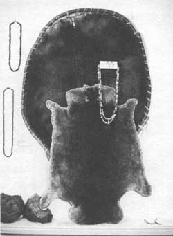
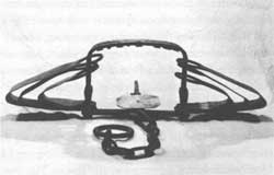
| This beaver trap, found in the Conant Pass area, is believed to have been used by Richard "Beaver Dick" Leigh. Jackson Hole Historical Society and Museum |
Most trappers were born between 1793 and 1810. More than 50 percent hailed from Canada, Kentucky, Virginia, and Missouri. The majority left for the mountains between 1825 and 1830. Forty-one percent worked at one time as free trappers, the top of the heap in the trapper's social hierarchy. They worked for themselves, selling their plews to the highest bidder. There are several surprises in Hafen's essay. The majority married white women rather than Indians. Most could read and write, which is contrary to the perception of mountain men as illiterate bumpkins. Finally, most lived to retire from the mountains; only 11 percent were killed by Indians. [82] Most of the subjects of the biographies left the mountains between 1810 and 1850, with 30 percent turning to farming and ranching. Missouri, California, and Oregon were the most popular places of retirement. [83]
Several figures who were known to have passed through Jackson Hole typify the range of personalities and experiences of mountain men. David E. or Davey Jackson remains an enigma. Though a prominent partner of Bill Sublette and Jed Smith, little is known of his life or activities. While Smith explored much of the West and Sublette supplied goods from St. Louis, Jackson directed the trapping operations of the partnership from 1826-1830. He was a capable field leader who was responsible in great part for the partnership's profits. During this period, Jackson Hole acquired its name. Whether this valley was Davey Jackson's favorite haunt is questionable, and the claim that he wintered in Jackson Hole is doubtful, but he used the trails through the enclosed valley to conduct trapping operations. Thus, it is likely that Jackson Hole acquired its name from Jackson, based on his role as a field manager for Ashley, Smith and Sublette. [84]
Robert Campbell was another graduate of the Rocky Mountain Fur Company's "school." Campbell was one of the few to profit from the fur trade. Born in Ulster, Ireland, he accompanied Jed Smith west to improve his health. Well-educated, Campbell served first as a clerk, and by 1832, earned the respect and right to be a bourgeois, leading trapping brigades into the heart of the wilderness. He experienced several close calls with the Blackfeet, proving his courage and sound judgment. Campbell later joined Bill Sublette supplying goods to the Rocky Mountain Fur Company. This provided the basis of his fortune in St. Louis, where he became a wealthy merchant, banker, and landowner. After the battle in Pierre's Hole in 1832, Campbell wrote "to confess the truth, I am heartily sick of it." True to his word, he abandoned the mountains for good in 1833. [85]
If Robert Campbell represented sound judgment seasoned with courage, Mark Head symbolized the image of the mountain man as a hell-raising wild-man dressed in buckskin. Mark Head went to the mountains in the trade's later years. He may have accompanied Sublette and Campbell's pack train west in 1832. It was late enough in the trappers' era that Head may have tried to live up to the developing image of a mountain man as a reckless and fearless frontiersman. At any rate, he attracted trouble. One contemporary recalled that his body was covered with scars from injuries and wounds. Mark Head took people literally. In 1834, an Englishman, Sir William Drummond Stewart, stormed about camp when he learned that an Indian named Marshall had stolen his favorite rifle and horse. Stewart rashly offered $500 for Marshall's scalp. Mark Head returned the next day with Stewart's favorite horse, prize rifle, and Marshall's scalp. Stewart appraised Head as "the best and most reckless trapper save one." One contemporary recollected that:
he possessed the most remarkable aptitude for getting into scrapes and out of them in a damaged condition of any man I ever knew. He had gunshot and arrow wounds, had been clawed by bears and horned by a buffalo bull. His endurance and recuperative powers were equalled only by his pluck and misfortune. I saw him once just as he had been brought out of a plum thicket into which he had followed a wounded cinnamon bear. When rescued he looked, to use his own expression, "as if he had been chewed up and spit through a rail fence."
Head drifted to the Southwest and was killed during the Pueblo revolt in 1847. His biographer concluded he "seems to have made an impression by reason of his rash temerity and that alone." [86]
Jedediah Strong Smith was not a typical trapper, but he stood head and shoulders above the rest. Largely forgotten until after 1900, Smith earned praise as one of the most accomplished explorers in American history. Only Lewis and Clark overshadow him. In eight short years, Smith rediscovered South Pass, became the first to reach California over land from the American frontier, was the first Euro-American to cross the Sierra Nevada, and was the first to journey across the Great Basin. Finally, partially owing to good luck, Smith survived three major disasters, the fight with the Arikari in 1823, the Yuma massacre on the Colorado River, and the massacre on the Umpqua in Oregon. More than 40 trappers were killed in these baffles.
Smith was unusual for a mountain man. He remained clean-shaven, while his comrades grew beards. He was literate and kept notes, something very few trappers bothered with, assuming they were literate. Unlike most of his contemporaries, Smith did not smoke or use profanity, and he drank only sparingly. Life in the wilderness did not diminish his strong religious convictions, rather it may have reinforced that faith. Smith's singular appearance, education, and manners were so extraordinary that Alexander Ross, the factor of the British Flathead House, was convinced that his American guest was a spy. Smith's comrades found him different, yet accepted him as a leader. Always to be counted on in a tight fix, he had the "har of the bar" in him, a trappers phrase for courage and reliability.
Jed Smith sold his interest in the Rocky Mountain Fur Company in 1830 and entered the Santa Fe trade in 1831. While scouting for water on the trail, he disappeared without a trace. The caravan moved on to Santa Fe without him. Only later was his fate learned. At an isolated water hole, he had been attacked by Comanches and killed. It was a lonely and ironic death, given the scrapes he had survived. Jed Smith's accomplishments as an explorer remain one of the great stories in American exploration. [87]
In seeking prime beaver country, mountain men came to know a West that is gone today. This West exists only in our imaginations, inspired by the wonderful artwork of Karl Bodmer, George Catlin, and Alfred Jacob Miller, or scarce contemporary accounts. It was a vast country of diverse and startling landscapes—plain, mountain, and desert—populated with abundant wildlife and occupied by free peoples. Perhaps the mountain mans' environment explains in part their stature as American folk heroes.
Yet, the fur trapper began the successive waves of Euro-American frontiers that altered the ecology of the West so drastically. Some of them knew it, too. The lack of beaver and buffalo on the Port Neuf River alarmed Osborne Russell in 1841, a short 17 years since Smith had first crossed South Pass. Once there were an estimated 200,000,000 beaver in North America. Mountain men trapped them to near extinction in many places. Today, the beaver population has recovered to an estimated 2,000,000 animals. There were once an estimated 60,000,000 buffalo in North America. Wild game provided the trapper with virtually all of his food. Buffalo was the favored meat. Bighorn sheep and dog (an Indian favorite) ran a distant second. What the mountain man began, later frontiersmen nearly finished. By 1900, fewer than 600 buffalo were believed to exist. [88]
The mountain man's frontier ended about 1840, the year of the last rendezvous. The trade declined abruptly after its peak in the early 1830s. Prime trapping grounds had been picked clean; beaver were scarce and easy profits a memory. More important, changes in fashion caused the price of beaver plews to plummet from as high as $6 a pound to less than $3 per pound in 1841, after silk hats became the rage in Europe. Moreover, rabbit felt also displaced beaver felt as material for hats. Last, intense competition crippled the trade. A brisk trade in buffalo hides continued after 1840, but the shining times of the 1820s and 1830s were gone. Isolation returned to Jackson Hole for 20 years until civilian and military explorers followed the trappers' tracks across the high passes.
Notes
1. Russell, Journal of a Trapper, p. 42.
2. Merrill J. Mattes, "Crossroads, 1807-1829," pp. 87- 108, Merril J. Mattes, "Jackson Hole Crossroads of the Western Fur Trade, 1830-1840," Pacific Northwest Quarterly 39 (1948): 3-32; and Hiram M. Chittenden, The American Fur Trade of the Far West: A History of the Pioneer Trading Posts and Early Fur Companies of the Missouri Valley and the Rocky Mountains and of the Overland Commerce with Santa Fe, 2 vols. (Stanford, CA: Academic Reprints, 1954), 1:306-307.
3. Paul Chrisler Phillips, The Fur Trade, with concluding chapters by J.W. Smurr, 2 vols. (Norman: University of Oklahoma Press, 1961), 1:3-14.
6. Billington, Westward Expansion, pp. 370-371.
8. Ibid.; and Chittenden, The American Fur Trade, 1:126.
9. For biographies of John Colter, see Stallo Vinton, John Colter. Discoverer of Yellowstone Park (New York: Edward Eberstadt, 1926); and Burton Harris, John Colter; His Years in the Rockies (Wyoming: Big Horn Book Company, 1952, reprint 1977).
10. Harris, John Colter, 36; and Mattes, "Crossroads, 1807-1829," p. 91. Dixon is also spelled as Dickson.
11. Harris,John Colter, p. 82. Quote from H.M. Brackenridge, Views from Louisiana Together with a Journal of a Voyage up the Missouri River in 1811 (Pittsburgh, 1814), p. 91.
12. Mattes, "Crossroads, 1807-1829," p. 92.
13. Harris, John Colter, p. 91.
15. Grand Teton National Park, Collections Accession File, "The Colter Stone," Accession File 63, 2 folders, F.M. Fryxell to National Park Service Director Arno Cammerer, May 8, 1934.
16. Paul Lawrence, John Colter: A New Look at an Old Mystery (Jackson, WY: Pioneer Press, 1978), pp. 13-14.
17. Department of the Interior, National Park Service, September 4, 1936, October 6, 1936, and June 5, 1937, Grand Teton National Park Files.
19. Harris, John Colter, pp. 108-109; and Aubrey Haines, "John Colter," The Mountain Men and the Fur Trade of the Far West, ed. LeRoy R. Hafen, 10 vols. (Glendale, CA: The Arthur H. Clark Company. 1965-1972), 8:78-79. This book is hereafter referred to as Mountain Men.
20. Haines, "John Colter," Mountain Men, 8:79-80.
21. Ibid., 8:76-80; Vinton, Colter: Discoverer of Yellowstone, pp. 58-61; Mattes, "Crossroads, 1807-1829," pp. 92- 93; Barry Maps, Grand Teton National Park Files; Harris, John Colter, pp. 73-114; and David J. Saylor, Jackson Hole, Wyoming: In the Shadow of the Tetons (Norman, OK: University of Oklahoma Press, 1970), pp. 8-34.
22. Harris, John Colter, pp. 152-165.
23. Mattes, "'Crossroads, 1807-1829," p. 93.
24. Ibid. Mattes made a reasonable inference that they crossed Togwotee Pass, based on their knowledge of the area, when they led the Astorians across the Rockies.
25. Washington Irving, Astoria, 2 vols. (Philadelphia, PA: Carey, Lea, and Blanchard, 1836; reprint, unabridged ed., Philadelphia, PA: J.B. Lippincott, 1961), 1:222.
29. Mattes, "Crossroads, 1807-;1829," pp. 97-;98; and Philip Ashton Rollins, ed., The Discovery of the Oregon Trail: Rohert Stuart's Narratives (New York: Charles Scribner's Sons, 1935), pp. 130-177. Stuart's party lost John Day, who went mad, but were joined later by Miller, who had left Hunt's party at Henry's Fort.
30. Irving, Astoria, 2:334; and Rollins, Discovery Oregon Trail, pp. 130-131.
31. Irving, Astoria, 2:337; and Rollins, Discovery Oregon Trail, pp. 134-135.
32. Rollins, Discovery Oregon Trail, p. 153.
33. Ibid., pp. 154-;186; and Mattes, "Crossroads, 1809-1829," pp. 97-98.
34. Chittenden, American Fur Trade, 1:221-223.
35. Billington, Westward Expansion, pp. 382-383.
36. Alexander Ross, The Fur Hunters of the Far West, ed. Kenneth A. Spaulding, reprint 1855 edition (Norman, OK: University of Oklahoma Press, 1956), p. 135.
37. Ibid., p. 167; and Mattes, "Crossroads, 1807-1829," pp. 99-100.
38. Mattes, "Crossroads, 1807-1829," pp. 99-100.
41. Edgar Stewart, "Finian McDonald," Mountain Men, 5:212-213; and Dale Morgan, Jedediah Smith and the Opening of the West (New York: Bobbs-Merrill Company), pp. 124-125.
42. Stewart, "Finian McDonald," Mountain Men, 5:213. According to Stewart, McDonald returned with 4,459 pelts, while Morgan cites a lower figure of 4,339 pelts. Either number represents a successful trapping season.
43. Mattes, "Crossroads, 1807-1829," p. 100.
44. Phillips, Fur Trade, 2:35; and Chittenden, American Fur Trade, 1:246-262.
45. Mattes, "Crossroads, 1807-1829," p. 101. See Dale Morgan's biography of Jed Smith.
46. Harrison Clifford Dale, The Ashley-Smith Explorations and the Discovery of a Central Route to the Pacific, 1822-1829, revised ed., (Glendale, CA: Arthur H. Clark Co, 1941), pp. 92-93.
47. Mattes, "Crossroads, 1807-1829," p. 102.
48. Morgan, Jedediah Smith, pp. 128-129.
49. Mattes, "Crossroads, 1807-1829," pp. 102.
50. Phillips, Fur Trade, 2:396.
51. Mattes, "Crossroads, 1807-1829," p. 102.
54. Chittenden, American Fur Trade, 1:288-289.
55. Frances Fuller Victor, The River of the West: Life and Adventure in the Rocky Mountains and Oregon (Hartford, CT: Columbian Book Col., 1870), p. 58.
56. Mattes, "Crossroads, 1807-1829," pp. 105-108.
57. Mattes, "Crossroads, 1830-1840," pp. 3-4.
59. Ibid; Russell, Journal of a Trapper; Warren A. Ferris, Life in the Rockies, ed. Paul C. Phillips (Denver, CO: Old West Publishing Co., 1940); and Mattes, "Crossroads," 1830-1840," p. 3.
60. Ferris, Life in the Rockies, p. 85; ed. F.G. Young, "The Correspondence and Journals of Captain Nathaniel J. Wyeth, 1831-1836," Sources of the History of Oregon, Vol. 1, Parts 3-6 (Eugene, OR: University Press, 1899), p. 158; and Russell, Journal, p. 15.
61. Young, Sources of History, p. 158.
63. Ferris, Life in the Rockies, pp. 156-158.
64. Rev. Samuel Parker, Journal of an Exploring Tour Beyond the Rocky Mountains, 4th ed. (New York: 1844), p. 88.
65. Russell, Journal of a Trapper, pp. 18-20.
66. Ibid., pp. 99-108; and Mattes, "Crossroads, 1830-1840," p. 29.
67. Ferris, Life in the Rockies, p. 156.
68. Russell, Journal of a Trapper, p. 90.
69. Mattes, "Crossroads, 1830-1840."
70. Russell, Journal of a Trapper, pp. 18-20.
72. Mattes, "Crossroads, 1830-1840," p. 10; and Washington Irving, Adventures of Captain Bonneville, 2 vols (New York: G.P Putnam's Sons, 1837), 1:76-84.
73. Victor, River of the West, pp. 253-255. This incident may well have occurred west of Teton Pass in Idaho.
74. Mattes, "Crossroads, 1830-1840," pp. 3-4.
75. Chittenden, American Fur Trade, 1:304-305.
76. Russell, Journal of a Trapper, p. 123.
78. Bernard DeVoto, Across the Wide Missouri (New York: Hougton Mifflin Co., 1947), pp. 158-160.
79. Phillips, Fur Trade, 2:574.
80. Chittenden, American Fur Trade, 1:7; and Billington, Westward Expansion, p. 355.
81. Richard J. Fehrman, "The Mountain Men—A Statistical View," Mountain Men, 10:9-15.
82. Ibid.; Chittenden counted 151 trappers killed by Indians between 1820-1831. One source claimed that Black feet and Gros Ventres were killing "an average of 50 Americans a year" by the 1830. I believe this is too high, but determining more accurate figures would be difficult, if not impossible. See Thomas F. Schiltz in "The Gros Ventres and the Upper Missouri Fur Trade, 1806-1835," Annals of Wyoming 56 (Fall 1984):21-28.
83. Fehrman, "Mountain Men—A Statistical View," Mountain Men, 10:9-15.
84. Carl D. Hays, "David E. Jackson," Mountain Men, 9:215-244; and Ferris, Life in Rockies, p. 157.
85. Harvey L. Carter, "Robert Campbell," Mountain Men, 8:49-60.
86. Harvey L. Carter, "Mark Head," Mountain Men, 1:287-293.
87. Harvey L. Carter, "Jed Smith," Mountain Men, 8:331-348.
88. Stephen H. Jenkins and Peter E. Busher, "North American Beaver," Mammalian Species (American Society of Mammalogists, June 8, 1979), No. 120; and Ed Park, The World of the Bison (New York: J.B. Lippincott Co., 1969), pp. 37-57.
| <<< Previous | <<< Contents >>> | Next >>> |
grte/hrs/chap3.htm
Last Updated: 24-Jul-2004