 | ||
 | ||
 | ||
 | ||
 | ||
 | ||
 | ||
 | ||
 | ||
 | ||
 | ||
 | ||
 | ||
 | ||
 | ||
 | ||
 | ||
 |
 |
 |
Chickamauga and Chattanooga National Military Park Tour Roads
Georgia and Tennessee
CREATING A COMMEMORATIVE ROADWAY
The park was initially run by a three-man commission appointed by the Secretary of War. This group's duties were to purchase the park property, open and repair park roads, and define the lines of battle for study and interpretation. Military records, diaries, and personal memories of the veterans were used to configure the park and its features. Commemorative plaques and markers were then installed to interpret the landscape.
From its inception, the park's efforts were geared towards development of an integrated unit of fields and roads commemorating the battles of Chicka- mauga and Chattanooga. From 1890 to 1892, the commissioners concentrated on establishing the approach roads and entrances to the park, and then clearing the fields of underbrush so that battle lines could be more easily established. The Civil War-era roads in the area were reestablished and opened for transit.
The park commission's primary concern was not construction of new roads, but maintenance of existing ones. The initial acts that created Chickamauga and Chattanooga National Military Park called for government ownership of all "approach roads" into the park, to be ceded by the states of Georgia and Tennessee. Once this occurred, planners could develop and improve these roads to accommodate heavy visitor traffic.
There were several points of focus for road development. One of the most important was the LaFayette Road, which had been the center of the 1863 battle. Park developers also sought to highlight Crest Road, which ran along the top of Missionary Ridge, as it contained both strategic points and scenic vistas. The approach roads between Lookout Mountain and Rossville, as well as the Dry Valley and Crawfish Springs roads were targeted. Plans also called for the construction of a great military road to run from the Sherman Reservation in northern Chattanooga south through the Chickamauga battlefield and conclude at the site of Lee and Gordon's Mill below the park boundary. Construction of this road began in 1892.
The task of restoring and reopening the battle-era roads in and approaching the park was a primary objective. A work crew of three hundred men lived in the park and toiled daily on the massive restoration project. The completed project was expected to require construction of nearly 50 miles of roadway.
Construction projects continued in 1893 with work on the road connecting Lookout Mountain with Rossville, a carriage drive at Point Park, surveys for construction of Crest Road, completion of LaFayette Road to Rossville and to a junction with the main route to Chattanooga.
After the park was officially dedicated and opened in 1895, the need to widen existing roads became a pressing issue. The overwhelming use of the main approach roads necessitated the widening of these routes, which required additional land acquisition from owners of properties along these roadways. Most of the roads leading to and through the park were completed by the turn of the century. In 1902, the LaFayette Road was continued south of the park to the corporate limits of LaFayette, Georgia. Additional improvements to the roads from Rossville to McFarland's Gap and from Crawfish Springs (present-day Chickamauga) to Glass' Mill were also completed. Feeling rather optimistic, Henry Boynton reported to the Secretary of War that this work should be the end of road construction in the park.
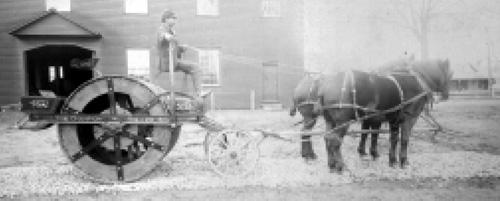
Horse-drawn equipment and hand tools were used to construct park roads, ca. 1893. (CHCH) |
| Introduction | Acadia | Blue Ridge Parkway | Chickamauga and Chattanooga | Colonial Parkway | Generals Highway | George Washington Memorial Parkway | Great Smoky Mountains | Mount Rainier | Rock Creek and Potomac Parkway | Shenandoah's Skyline Drive | Southwest Circle Tour | Vicksburg | Yellowstone | Yosemite |
