|
National Park Service U.S. Department of the Interior Fort Clatsop National Memorial Astoria, Oregon |
 |
Draft Boundary Study and Environmental Assessment
| Introduction |
Vision Statement
Significant sites exist all along the Lewis and Clark National Historic Trail, but the extraordinary history related to the Lewis and Clark Expedition's dramatic and conclusive arrival at the Pacific Ocean can only be truly understood at three sites on the lower Columbia River that are the subject of this study. By successfully reaching the Pacific Ocean, the Corps of Discovery accomplished President Thomas Jefferson's directive and helped the United States of America claim land west of the newly acquired Louisiana Purchase. These sites on the lower Columbia are Megler Safety Rest Area (Clark's Dismal Nitch), Station Camp, and Cape Disappointment at Fort Canby State Park. These sites are strongly associated with the Lewis and Clark Expedition's Corps of Discovery, and as such should be protected over the long term to commemorate this important history. These sites should be places where visitors can learn about the last days of the Corps of Discovery's epic journey westward, the relationships between the Corps and the American Indian tribes of the lower Columbia region, and other historic events that took place at each of these locales. Although man and nature have altered the lower Columbia since Lewis and Clark visited the area in 1805, the distinctive landforms that the explorers described and mapped are still easily discernible to modern-day students and travelers. Preservation of these sites will ensure that future generations can continue to experience the landscape and vistas at the confluence of the Columbia River and Pacific Ocean as was encountered by the Corps of Discovery in 1805.
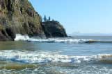 North Head Lighthouse |
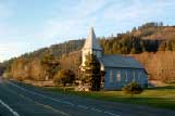 St. Mary's Church at Station Camp |
 Megler Safety Rest Area |
Study Background
This boundary study has been prepared by the National Park Service (NPS) in response to a directive by Congress. The NPS prepared this study in conjunction with a team made up of five state agencies representing Washington and Oregon, along with representatives from local communities in Pacific County, Washington. The need to study these sites has been identified as a result of a new generation of Lewis and Clark scholarship and the broad national interest in the upcoming bicentennial commemoration.
|
|
Tourists from all over the country and the world will be visiting sites along the Lewis and Clark National Historic Trail during the bicentennial to learn about and honor the achievements of this remarkable group of explorers. The commemoration of the Corps of Discovery's journey westward spans a four year period (2003-2006). The National Bicentennial Council (NBC) has designated signature events in many state and tribal homelands through which the trail runs and will commemorate a specific, noteworthy event in each area. These events commenced with a kickoff on January 18, 2003 in Charlottesville, Virginia, and will end in St. Louis, Missouri on September 23, 2006. The signature event for the west coast, "Destination The Pacific," will take place over the Thanksgiving holiday in 2005. Pacific County, Washington and Clatsop County, Oregon are already planning for this event, which include the NPS Corps of Discovery II Traveling Exhibit. Much of the planning for "Destination The Pacific" centers around the Corps of Discovery's experience on the lower Columbia at several sites, including Megler Safety Rest Area, Station Camp, Fort Canby State Park, Fort Clatsop, Fort Stevens State Park, and Ecola State Park.
For the past four years, the state of Washington has been actively involved in preparing for the bicentennial and the potential increase in visitation. An Agency Assistance Team (AAT) was formed and is made up of representatives from the Washington State Historical Society (WSHS), Washington State Parks and Recreation Commission (WSPRC), Washington State Department of Transportation (WSDOT), Washington State Tourism Office, Washington State Arts Commission, and the Washington National Guard. Working with local communities and tribes, the AAT has identified priority projects and is currently in the process of designing and installing interpretive panels and information kiosks all along the trail in the state of Washington.
Realizing the significance of Station Camp in the story of the Lewis and Clark Expedition, the WSHS advocated for the development of a park to commemorate this important place in American history. WSHS is working with the National Park Service (NPS), WSDOT, WSPRC, and other state agencies to develop this park as a key component in Washington's effort to fully interpret the Lewis and Clark story. Native American tribes from along the trail are also working closely with the agencies to provide the tribal perspective of the story.
Through the preparation of this study, it became evident that a regional approach to agency coordination, interpretation, and transportation was an important factor in strengthening the overall visitor experience.
As the planning team began to evaluate the lower Columbia Lewis and Clark sites, it became apparent that at least one of the alternatives considered for inclusion in the study analysis should address the Oregon Lewis and Clark sites not already included in Fort Clatsop National Memorial. For that reason, Oregon State Parks was approached and Management Alternative D reflects their input.
This study presents an evaluation of the national significance, suitability, and feasibility of expanding Fort Clatsop National Memorial to include Megler Safety Rest Area (Clark's Dismal Nitch), Station Camp, and Fort Canby State Park (Cape Disappointment). It also presents outlines for and analysis of a variety of management alternatives for protecting and interpreting the history of these sites. Finally, an evaluation of the alternatives is included, with regard to environmental consequences to cultural and natural resources, socioeconomics, transportation, and visitor experience.
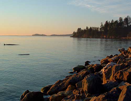
View of Cape Disappointment from Station Camp
Purpose and Need
The National Park Service, under direction from Congress, studies natural, historical, and recreational areas to determine their national significance and worthiness for inclusion in the National Park System.
|
|
This study was prepared in accordance with Public Law 107-221 (See Appendix A) within which Congress directed the study. Congress forwarded the legislation to the White House and it was signed into law by President George W. Bush in August 2002. In it, the National Park Service was charged with studying three Lewis and Clark sites on the lower Columbia River.
The sites being studied for potential inclusion in the boundary of Fort Clatsop National Memorial are: Megler Safety Rest Area (Clark's Dismal Nitch), Station Camp, and Fort Canby State Park (Cape Disappointment).
The purpose of this study is to provide information to Congress regarding the significance of these three sites in American history as well as to analyze the suitability and feasibility of designating the sites for potential inclusion in Fort Clatsop National Memorial.
The study provides two measures of analysis. First, since the three sites are being considered for addition to Fort Clatsop National Memorial, NPS boundary adjustment criteria was applied.
The analysis of boundary adjustment criteria was prepared in accordance with NPS Management Policies which are in conformance with the applicable provisions of the Arizona Desert Wilderness Act (Public Law 101-628).
The boundary analysis conducted in the study utilized the following criteria:
Significant resources or opportunities for public enjoyment related to the purpose of Fort Clatsop National Memorial
Operational and management issues related to access and boundary identification by topographic or other natural features
Protection of national memorial resources and fulfillment of purpose of Fort Clatsop National Memorial
Feasibility to administer the lands added through boundary adjustment
Protection alternatives considered
Proposed additions to the Fort Clatsop National Memorial boundary and other adjustments
Second, as directed by Congress, an analysis was conducted of the national significance, suitability, and feasibility of the inclusion of these sites within Fort Clatsop National Memorial. Also included is an examination of management alternatives for the future protection and public use of these sites. This analysis was prepared in accordance with Public Law 105-391 (See Appendix B). This law, which amended (Public Law 91-383, Section 8), prescribes the criteria and process necessary to evaluate sites and resources for their potential inclusion in the National Park System. In this case, their potential addition to Fort Clatsop National Memorial.
Following completion of public review of the draft study the report will be finalized and forwarded to the Department of Interior for submittal to Congress in accordance with Public Law 107-221.
Finally, in order to properly evaluate the potential effects of implementing any one of the four management alternatives presented in the study, an environmental assessment (EA) was prepared as a combined document. The EA was prepared in compliance with the National Environmental Policy Act (NEPA) and implements the regulations of the Council of Environmental Quality. Applicable departmental and bureau policies and guidelines were also addressed in preparation of the EA.
Regarding the environmental consequences of the highway re-route and park development proposed at the Station Camp site by the state of Washington, a separate environmental assessment has been prepared and should be referenced to ascertain the affects of this specific development proposal. This soon to be released environmental assessment is entitled, U.S. Highway 101 Realignment at Station Camp Park
Lewis and Clark on the Lower Columbia River
The Lewis and Clark Expedition was one of the greatest explorations in American history. President Thomas Jefferson commissioned the Expedition to study and map a passage west through the recently purchased Louisiana Territory.
President Jefferson instructed his Corps of Volunteers for Northwestern Discovery, as they were officially named, to look for any navigable passage to the Pacific Ocean.
On October 10, 1805, after 17 arduous months, the Expedition entered what is now Washington State. As they traveled swiftly down the Snake and Columbia rivers, the party began to notice signs that they were nearing the Pacific Ocean.
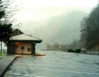
Megler Safety Rest Area
(Clark's Dismal Nitch)
It is evident from the journals that the close proximity of the ocean
aroused much joy and excitement within the Corps. On November 7, 1805,
Clark wrote, "Great joy in camp we are in View of the Ocian, this
great Pacific Octean which we been So long anxious to See. And the
roreing or noise made by the waves brakeing on the rockey Shores (as I
Suppose) may be heard distictly."
From this emotional high, the Corps of Discovery quickly dropped to an emotional and physical low as a storm brought fierce winds, high waves, and torrential rains. The Corps, comprised of strong, determined people, had journeyed thousands of miles in heat, cold, wind, and rain. This Pacific storm severely hampered their forward movement and they became trapped for six days.
Clark's Dismal Nitch is located near present-day Megler Safety Rest Area. It was here the Corps was pinned against the shoreline, taking shelter from the wind and rain while trying to protect themselves from the tremendous waves "brakeing with great fury against the rocks and trees on which we were encamped. Our Situation is dangerous." This is the only time during the entire expedition that William Clark used the word "dangerous" to describe the party's situation. In an extended comment, Clark notes that a "feeling person" would be distressed to see the circumstances of the party.
Their canoes were in danger of being crushed by driftwood colliding against the shoreline. To compound matters, they were soaked to the bone, and their clothes were rotting off their backs. Many were seasick from the rolling of their canoes on the river swells.
Station Camp
After being marooned for six long days and enduring the harshness of the
elements, the wind and river calmed enough to allow passage around
"Point Distress" (Point Ellice). Once around the point, "a
butifull Sand beech" revealed itself to the party at what they
called Station Camp. Here, the Corps of Discovery had their first
comprehensive view of waves of the Pacific Ocean. After traveling
thousands of miles up the Missouri River, over the Rocky Mountains, and
down the Snake and Columbia rivers, the Corps had finally accomplished
Thomas Jefferson's goal of finding a route to the Pacific Ocean. The
Corps spent over ten days at this site, an extraordinarily long period
of time in comparison to other campsites along their journey. It was
here that the members of the party took pride and pleasure in stating
through their journal entries that they had accomplished their mission
and reached the "end of our voyage." The location of this
campsite was considered so important that William Clark specifically
surveyed and mapped its location. It is one of the few sites of the
entire voyage to be surveyed in such detail.
At Station Camp, the party met with various tribes from the region, and learned of the activities of trading ships that had regularly been coming to the mouth of the Columbia. Also, on November 24, 1805, in an act of leadership symbolic of the American spirit, the captains asked each member of the group (including Sacagawea, a Native American woman, and York, an African American slave) to state his or her preference for the location of winter camp.
|
"I proceeded up the course& marked my name & the Day of the Month on a pine tree" William Clark, November 19, 1805 |
Fort Canby State Park
(Cape Disappointment)
While at Station Camp, Clark took 11 men on an excursion to the ocean on
November 18, 1805. They proceeded to Cape Disappointment, crossed the
cape to the west, camped for one night near McKenzie Head, and then
headed due north across the rugged headlands to the beach. Early on
November 19, the party reached the Long Beach Peninsula's expansive
sandy shore. The men proceeded north up the beach, approximately four
miles. Clark wrote, "I proceeded up the course& marked my name
& the Day of the Month on a pine tree" This was the furthest
point of exploration by the Corps. The party then returned to Station
Camp.
The events at Clark's Dismal Nitch, Station Camp, and Cape Disappointment exemplify a great American story. From physical misery and treacherous waters to the beautiful sandy beach and exploration up the coastline, both the struggle and bond between man and nature were captured. Not until one understands the dire situation at Clark's Dismal Nitch can one appreciate the Corps' joy in seeing a full view of the ocean. The full story of the final push to the Pacific Ocean can only be fully appreciated with an understanding of the events of each of these three sites.
Site Descriptions: Existing Conditions
The boundary study for the lower Columbia River Lewis and Clark sites includes three areas: Megler Safety Rest Area, Station Camp and Fort Canby State Park. All three sites are located near the mouth of the Columbia River in the southwest corner of Washington State in Pacific County.
|
|
|
"It would be distressing to a feeling person to See our Situation at this time all wet and cold with our bedding &c. also wet, in a Cove Scercely large nough to Contain us." William Clark, November 12, 1805 |
Megler Safety Rest Area
(Clark's Dismal Nitch)
Safety Rest Area is located on State Route 401, one mile east of the
Astoria-Megler Bridge. The rest area is owned by WSDOT. Presently, the
site offers restrooms, a visitor information booth (open seasonally),
and parking. Picnic tables are situated on a grassy area overlooking
the Columbia River. Although currently there are no interpretive panels
at the rest area, the AAT proposes to install interpretative displays
related to the Corps of Discovery's time in the area. This will consist
of two single interpretive panels and a kiosk.
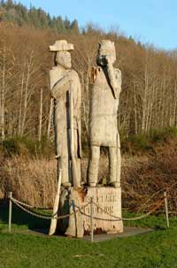
Station Camp
Three miles west of Megler Safety Rest Area on U.S. Highway 101 is the
site of Station Camp. The existing highway is immediately adjacent to
the shoreline of the Columbia River and runs through the Station Camp
site. The Washington State Parks and Recreation Commission owns one acre
of land northeast of the highway, named Station Camp State Park, which
includes a 15 to 20 foot tall wooden carving of Lewis and Clark, a
picnic table, and a single interpretive panel explaining the
significance of the site. The remaining land surrounding this wayside
park is privately owned.
Most of the surrounding private property is owned by descendants of the McGowan family, the first European-Americans to settle on this property more than 150 years ago. The other significant private ownership at the Station Camp site is St. Mary's Church, which was established in 1904 by the Roman Catholic Church.
Fort Canby State Park
(Cape Disappointment)
Fort Canby State Park is located west of Ilwaco on U.S. Highway 100. The
park encompasses much of the southern portion of Cape Disappointment.
Fort Canby State Park, managed by the WSPRC, is an 1,883-acre park on
the Long Beach Peninsula, fronted by the Pacific Ocean.
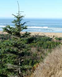
The park consists of 27 miles of ocean beach, two lighthouses, an interpretive center devoted primarily to the history of the Lewis and Clark Expedition, and hiking trails. Beachcombing, camping, and natural and cultural history are just a few of the features that draw visitors to this state park. Nearby coastal towns include Ilwaco, Seaview, and Long Beach.
The Lewis and Clark Interpretive Center, undergoing renovation at the writing of this document, will house enhanced interpretive material on the Corps of Discovery focusing on the 18 days the Corps spent in Pacific County. Other interpretive material at the center addresses Captain Robert Gray's trip up the Columbia River, the Cape Disappointment Lighthouse, and the function of the fort as a coastal defense site. Figure 1.1, below, illustrates the study site locations.
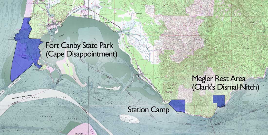
Figure 1.1 Location map of study sites.
(click on
image for an enlargement in a new window)
| <<< Previous | > Contents < | Next >>> |
focl/draft_boundary_study/sec1.htm
18-Jul-2003