|
National Park Service U.S. Department of the Interior Fort Clatsop National Memorial Astoria, Oregon |
 |
Draft Boundary Study and Environmental Assessment
| Affected Environment |
The natural setting of the lower Columbia River, with its rocky cliffs, towering evergreens, stretches of sandy beach, and outstanding water views, brings the story of Lewis and Clark's final approach to the Pacific Ocean to life. Where the river flows into the sea, visitors can come to explore the final chapter of the epic voyage and imagine the drama of finally reaching the Pacific. Highlighting this final chapter of the voyage are the sites of Megler Safety Rest Area (Clark's Dismal Nitch), Station Camp, and Fort Canby State Park (Cape Disappointment). Each site's unique landscape and history contributes to the greater story of Lewis and Clark's "end of our voyage."
In Pacific County and across the Nation, preparations are underway for the bicentennial commemoration of the Lewis and Clark Expedition. Part of this work in Pacific and Clatsop counties involves accommodating the expected influx of tourists and traffic to the area. Strategies for providing access to the area's attractions without overwhelming their resources include dispersal of visitors to various historic sites, shared parking facilities, and a bus shuttle system. Coordinated efforts for welcoming and directing visitors to the area's local destinations, special events, activities, and retail services are being developed. Envisioning the visitor experience at the study sites during the bicentennial commemoration has been the impetus for assessing resources and making suggestions for improvements.
This section discusses the cultural and natural resources of each study site as well as the regional setting. It includes a description of existing conditions and provides the basis from which the potential effects on resources and the environment can be measured if any one of the alternatives presented in the study is implemented.
Cultural Resources
Significant elements of the affected environment are the cultural resources described through the historic sites, archaeological resources, the cultural landscape, changes in the landscape, and historic land features.
Historic Sites
Each of the three study sites have a significant history associated with the Lewis and Clark Expedition.
|
"this dismal nitich, where we have been confined for 6 days passed, without the possibility of proceeding on, returning to a better Situation, or get out to hunt, Scerce of Provisions, and torents of rain poreing on us all the time" William Clark, November 15, 1805 |
Megler Safety Rest Area
(Clark's Dismal Nitch)
As the Corps of Discovery neared the mouth of the Columbia, they felt
immense joy at the possibility of reaching their final destination, the
Pacific Ocean. However, the stretch to the ocean proved to be extremely
difficult. For several days the Corps was pinned against the shoreline
in the vicinity of today's Megler Safety Rest Area, trying to shelter
themselves from strong wind, waves, and rain. The Corps camped in a low
bottom at the mouth of a stream as described by William Clark, "we
took the adventage of a low tide and moved our camp around a point to a
small wet bottom at the mouth of a Brook."
They were soaked to the bone, their clothes were rotting off their backs, many were seasick from the rolling of their canoes on the river swells. On November 15, before setting out around Point Ellice, Clark referred to this camp as the Dismal Nitch, where the party had been confined, unable to proceed in the face of significant danger from the elements.
|
|
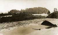
Station Camp
On November 15, 1805, the Corps of Discovery finally made it around
Point Ellice (or Blustering Point or Point Distress as they called it)
and established a terminus camp on a "butifull Sand beech" east
of the present town of Chinook, Washington. With the full view of the
ocean in sight, Sergeant Patrick Gass of the Corps of Discovery recorded
in his journal, "we are now at the end of our voyage." The Corps
stayed at Station Camp, until November 25. Operating out of this base
camp, Lewis and Clark separately led local reconnaissance trips, and met
and traded with local tribes from the area. From this site, Clark
surveyed their location and recorded his observations and calculations
in his journal.
Having completed their mission, it was time for the Corps of Discovery to make a decision about the location of winter camp. The vote for selection of a winter camp took place on November 24, 1805. The Corps considered two basic choices: either build a winter camp upstream near the Columbia-Sandy River, "Quicksand River," confluence, or remain near the ocean.
This vote was significant because the captains polled every member of the party as to where they should make winter camp. In an exemplary show of leadership, Lewis and Clark asked the opinion of all the men; sergeants, privates, boatmen, hunters, including, Clark's African American slave, York, and Sacagawea, the Shoshoni Indian woman with them on their journey to the ocean.
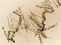
The name Station Camp is a reference to the survey stations and traverse William Clark surveyed to accurately locate this campsite for his journal. From the campsite's sandy beach, Clark shot his traverse to five prominent landforms. This is one of only four places along the journey where Clark used chains to more accurately calculate distances rather than his typical method of pacing. From his observations and calculations, Clark created a map of the Station Camp vicinity. Modern surveyors have located Clark's station point within a few feet.
Fort Canby State Park
(Cape Disappointment)
En route to Cape Disappointment, Lewis (on November 15, 1805) and Clark
(on November 18, 1805) each explored an anchorage site in hopes of
finding European-American trading ships. The isthmus crossing area, a
low area between Baker Bay on the Columbia River and the Pacific Ocean
shore, is believed to be the location where members of the Lewis and
Clark Expedition crossed Cape Disappointment on November 18, 1805.
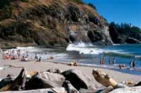
Waikiki Beach is believed to be the location of the Lewis and Clark
Expedition's first encounter with the waters of the Pacific Ocean.
On the evening of November 18, 1805, Captain William Clark and 11 members of the Corps of Discovery camped on the beach of Cape Disappointment, near present-day McKenzie Head, as they traveled through the area.
After breaking camp on the morning of November 19, 1805, members of Clark's party crossed the rugged terrain of the headlands near North Head on the way to the Long Beach Peninsula.
From the North Head area, Clark's party probably traveled through a hollow (now known as Beard's Hollow) after descending the headlands of Cape Disappointment to the long, sandy beach which extends several miles to the north.
Early on November 19, 1805, Clark's party reached the Long Beach Peninsula's sandy shore. The men proceeded north up the beach approximately four miles, exploring the area before returning to Station Camp.
Archaeological Resources
|
|
Before European-Americans arrived, the coastal areas extending from Tillamook Head near Seaside, Oregon, up to Willapa Bay, Washington, were densely inhabited by native people. Archaeological research and excavation of the area began in the late 1940s.
Megler Safety Rest Area
(Clark's Dismal Nitch)
Several Chinook summer villages existed along the Columbia River from
Cape Disappointment to Grays Bay. European-American explorers and fur
traders referred to these villages by name. Two of the villages were in
close proximity to today's Megler Safety Rest Area. Qaiiltsiuk was
approximately one and one half miles below Megler (upstream from Point
Ellice) and Kekaiugilhan was approximately two miles below Megler
(downstream from Point Ellice, near the Station Camp site).
Station Camp
At the time of contact with the Lewis and Clark Expedition, people who
became known as the Chinook inhabited the lower Columbia area. The
Chinook, who relocated bi-seasonally, had permanent winter villages
along the protected shores of Willapa Bay and summer villages and field
camps along the Columbia River. When the Corps of Discovery reached
Station Camp, they encountered a deserted Chinook village of 36 houses
and noted that the Chinook had already vacated the village and moved to
winter houses along protected rivers and bays to the north.
Years later, in the mid-1800s, American settlements began along the lower Columbia River. Taking advantage of the abundant and predictable salmon runs along the north shore between Point Ellice and Baker Bay, Peter McGowan developed a salmon cannery and town near the Old Chinook Village and Station Camp site.
In 1904, St. Mary's Catholic Church was constructed within the McGowan town site. Still in existence today, the Church is a major landmark along Highway 101 in Pacific County and is open for summer services.
In November 2002, a draft report, "Management Summary: Archaeological Survey and Test Excavations at Lewis and Clark's Station Camp," was prepared by the NPS. The research included analysis of historic maps and other documents, interviews with local residents, visual observations, and excavation and analysis of 50 shovel probes within the Station Camp project area. The excavation yielded very little material culture which could be associated with Native American use of the project area. An explanation for the lack of Native American artifacts may be due to the loss of land caused by shoreline changes introduced with the construction of the jetties on the Columbia River.
Fort Canby State Park
(Cape Disappointment)
Archaeologists' and ethnographers' research indicates that there were
abandoned Chinook summer villages in the Fort Canby area during the time
of Lewis and Clark's Expedition. Excellent fishing during low tides made
Cape Disappointment a favorable location for the Chinook villages of
Walumlum and Noxsxa'itmuts.
|
|
In 2002, archaeological field investigations were conducted in the Fort Canby area. A summary was prepared of archaeological findings and recommendations. Within the study area, two prehistoric and four historic period sites were found. Field investigations did not find any artifacts relating to Lewis and Clark's Expedition. During the excavation of a narrow ravine north of Beard's Hollow, researchers found shell and fire-cracked rock. Additional prehistoric artifacts were found in Fort Canby's former military parade ground just southeast of the existing park contact station. These recently recovered prehistoric artifacts are thought to be associated with a Native American site previously identified along the shores of Baker Bay.
Within Fort Canby, four historic period sites were documented. To the south of the park contact station, field investigators identified historic period artifacts and a row of three spruce trees that were probably planted in the 1870s. Also found near this area were historic artifacts associated with WWII-era concrete foundations. A 20th century shipwreck was documented at the southern base of North Head.
In addition, investigators found a historic period trash dump and concrete foundations at the top of North Head. Historic period artifacts were found near the park contact station and North Head. The study recommends preserving the archaeological sites from any proposed ground-disturbing activities. There is also an opportunity to illustrate the diverse history of the park to visitors by exhibiting and interpreting archaeological sites and artifacts as appropriate.
The Cultural Landscape
In May of 1792, Captain Robert Gray anchored his brig off Chinook Point, sailed about 20 miles upstream to conduct a more extensive exploration of the lower Columbia than was conducted by Lt. William Broughton for the British in October of 1792, and named it the Columbia River. Based on those previous explorations, and others, when Lewis and Clark reached the Columbia River in 1805, they were effectively back on the map of known territory for the first time since they had left the Mandan Villages in present-day North Dakota the previous April.
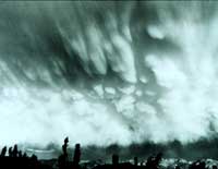
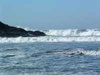
At the time, the Columbia River was immensely powerful, unbridled by dams and facing the Pacific Ocean without the effects of jetties. Then as now, this area is struck by frequent and treacherous coastal storms between October and April, characterized by steady rain, winds that have been recorded in excess of 160 miles per hour, and ocean swells reaching 40 feet in height traveling several miles up the river. The Lewis and Clark Expedition was totally exposed to the elements when it arrived at the mouth of the Columbia River.
|
|
At the Dismal Nitch, Lewis and Clark's party felt the full effect of a long duration coastal storm. They survived a harrowing six-days, pinned to a rocky shoreline of steep cliffs and thick forests and buffeted by crashing waves and driftwood logs. To the back of their narrow campsite was a steep rocky hillside that made it nearly impossible for members of the Corps to go out and hunt for food. Clark stated, "where I can neither get out to hunt, return to a better situation, or proceed on."
The rain persisted for days and their food supply was dwindling. When the tide subsided, the Captains noticed a way around the shoreline to a small stream. The Corps buried the canoes with rocks, and carrying only the most essential supplies, made it to the stream and traversed up a narrow holler with giant cedar and spruce trees. From this new campsite, the party was able to fish from the stream and wait out the storm. Finally the weather improved, and the Corps of Discovery arrived at Station Camp, encountering a deserted summer village of the Chinook.
Clark surveyed in great detail the location of Station Camp and the surrounding prominent landforms. These landforms are visible today from the Station Camp site.
Lewis and Clark met with several of the tribes from the area and engaged in trade. The tribes informed the Captains of the site at Cape Disappointment where European ships often anchored and traded with them.
Lewis and Clark led separate excursions to Cape Disappointment in the hope of meeting with trading ships. Unfortunately, neither Captain encountered one. On November 18, 1805, Clark took 11 members of the Corps with him and camped near McKenzie Head. On their trek to Cape Disappointment, Clark's party stopped and carved their names in trees along the route. The next morning, they traveled through Beard's Hollow, descended the headlands and reached the sandy shore of the Long Beach Peninsula.
On November 24, 1805, with the assurance from Clatsop Indians of plentiful fish and game on the south bank of the river, the Corps of Discovery voted to explore the prospects of establishing a winter camp on the other side of the Columbia. With the knowledge that the north side of the river would receive the brunt of the winter coastal storms, they crossed the river to the south shore and made their winter camp of 1805-06 and built Fort Clatsop.
Changes in the Landscape
Over the last 200 years, the landscape has changed as a result of both natural and human factors.
Megler Safety Rest Area
(Clark's Dismal Nitch)
Before the Astoria-Megler Bridge opened in 1966, Megler Safety Rest Area
was a ferry landing. The ferry service started in the 1930s and operated
until the bridge opened. A waterfront restaurant operated during the
days of ferry service. Some of its wood pilings still remain in the
water.
In 1960, State Route 401 opened and Megler Safety Rest Area was built on a filled portion of the ferry landing site during the years of 1964 and 1965. The early 20th century construction of a railroad and eventually the state highway, along the railroad alignment, has changed the configuration of the Columbia River shoreline at this site. The surrounding forested landscape has been timbered in the past but currently has fairly mature vegetation.
Today, the public can still discern the Dismal Nitch at the confluence of Megler Creek and the Columbia River.
Station Camp
In 1853, Patrick J. McGowan took a donation land claim in the vicinity
of Station Camp where he later started a commercial salmon packing
business, thereby establishing the town of McGowan. Today, several
buildings from the early days of the McGowan settlement remain.
Serving as the major landmark of the area, St. Mary's Church (also known as McGowan Church) sits immediately to the north of U.S. Highway 101 on the Station Camp project site.
Also on the Station Camp site is a 1970 residential duplex, a foundation of a milking shed, and dilapidated remains of a Shell gas station, bait house, McGowan-era "bachelors' quarters," and smokehouse. Other remaining McGowan-era buildings are the 1911 Henry McGowan House and "the office" constructed in 1903, just north of the Station Camp project site. The cannery facility, once located on pilings out on the river, has been entirely removed.
The installation of riprap during the construction of Highway 101 significantly altered the north shore of the Columbia River. As a consequence of construction along with the formidable changes in river flow created by dams upstream, it is thought that much, if not all, of the old Chinook village and the campsite at Station Camp have washed away and are now covered by the highway or the modern elevated water levels in the Columbia River Estuary.
Although the Station Camp site is still rural in character, the vicinity's native vegetation has been altered through historic land uses. The riprap embankment to the south of Highway 101 has no vegetation. Immediately to the north of the highway are areas of residential landscaping, fields of non-native Scot's Broom, two small areas of shrubs, and forested and emergent wetlands. The hillside to the north has been logged in the past and is now a second-growth forest of deciduous and coniferous trees. Further to the north, the forest consists of old-growth stands of Sitka spruce, Douglas fir, and western hemlock.
Fort Canby State Park
(Cape Disappointment)
The most dramatic change in the Cape Disappointment landscape since the
Lewis and Clark Expedition has been the accretion of land resulting from
the construction of the North Jetty. As a result of this process, the
beachfront dunes on which Clark's party had camped have transformed into
an emerging alder forest. Interestingly, this process is now reversing.
Since the damming of the Columbia River in the 1950s, the river's
ability to move and deposit sand has slowed. The localized result has
been the erosion of previously accreted land.
Historic Land Features
|
|
Megler Safety Rest Area
(Clark's Dismal Nitch)
The most apparent preserved feature in this landscape is the
unobstructed view of the Columbia River from the Megler Safety Rest
Area. Directly to the north- west of the rest area lies undeveloped land
believed to be the site of the Dismal Nitch. The forested hillside
surrounding the creek and the low bottom where the Corps made its
retreat to slightly higher ground remain today.
Station Camp
Visitors who cross the highway and climb atop the riprap shoreline are
able to see a full view of the ocean. This expansive ocean view is
probably the most essential feature for relating the Lewis and Clark
"end of our voyage" story. Also, supporting the Station Camp
story are views (although they are interrupted with modern development)
to all the points of land and topographic peaks referenced in Clark's
survey.
Although the lands have been logged since the Lewis and Clark Expedition, the forested slopes to the north of Station Camp create a similar evergreen backdrop to that seen by the Corps of Discovery.
Fort Canby State Park
(Cape Disappointment)
Today, much of the land features, vegetation, and wildlife habitat at
Fort Canby are the same as what Lewis and Clark experienced in 1805.
Visitors currently experience a similar landscape of steep rocky cliffs
tufted with tall coniferous trees, coastal headlands, estuarine
wetlands, large protected areas of classic Pacific Northwest old growth
forest, coastal dunes, and sandy stretches of shoreline dotted with
driftwood. North Head and McKenzie Head continue to be prominent
features in the landscape.
Saddle Mountain is still visible from the Chinook Point/boat launch turnaround and Waikiki Beach. This is the sacred place where the Chinook people believe they were created.
Other Similar National Park Resources
Though the journey of Lewis and Clark spanned the western frontier of the United States, there are only two National Park Service administered areas fully dedicated to the interpretation of the Lewis and Clark Expedition, and one other park area with significant interpretative material.
The former are the Lewis and Clark National Historic Trail and Fort Clatsop National Memorial. The other park area with significant Lewis and Clark interpretation is the Jefferson National Expansion Memorial, also know as "The Arch" in St. Louis.
The two other national park areas along or near the route of the Expedition (Knife River Indian Villages and Nez Perce Historical Park) also have interpretation related to the Lewis and Clark story, along with other interpretive themes.
Lewis and Clark National Historic Trail
Illinois, Missouri, Iowa, Nebraska, South Dakota, North Dakota,
Montana, Idaho, Oregon, Washington
The Lewis and Clark National Historic Trail starts in Wood River,
Illinois and follows the course of the Lewis and Clark Expedition to its
end at the mouth of the Columbia River. This is not a walking or
bicycling trail, rather it is a collection of sites along an automobile
route that relate to the Lewis and Clark story. Visitors may piece
together the events of the Lewis and Clark Expedition by stopping at
interpretive sites along the trail.
The National Park Service certifies official sites along on the Lewis and Clark National Historic Trail. Certification does not imply ownership by the NPS. Certification is gained through an agreement between the site's operating agency and the NPS to meet certain National Park Service criteria. The most basic of these requires the site to be open to the public and have interpretative material related to the Lewis and Clark Expedition. With certification, the interpretive site gains the use of the Lewis and Clark National Historic Trail symbol, interpretive brochures supplied by the National Park Service, and the National Park Service logo.
All three study areas are among the few campsites along the trail which can be precisely located. Of the three areas, Fort Canby State Park and Station Camp are both officially certified sites on the Lewis and Clark National Historic Trail.
Fort Clatsop National Memorial
Astoria, Oregon
Fort Clatsop is near the western terminus of the Lewis and Clark Trail
near Astoria, Oregon. The park focuses on the Expedition's winter camp
of 1805-06. There is some reference to the Columbia River experience,
but most of the interpretation is concentrated on events surrounding
Fort Clatsop.
Lewis and Clark's experience on the lower Columbia River and the accomplishment of reaching the Pacific Ocean are not fully represented at Fort Clatsop National Memorial. Some reference to this portion of the journey is interpreted at Fort Clatsop. However, the elation and satisfaction of reaching the Pacific Ocean and site-specific history related to the lower Columbia campsites have not yet been fully captured through interpretation by the National Park Service.
Jefferson National Expansion Memorial
St. Louis, Missouri
Also known as "The Arch," the Jefferson National Expansion Memorial in
St. Louis commemorates the Louisiana Purchase, Jefferson's vision for
America, and the spirit of the western pioneers. The interpretation of
the Lewis and Clark Expedition is a significant element in the overall
interpretive program at the memorial. A Lewis and Clark exhibit is
located in the museum beneath the Arch.
Knife River Indian Villages National Historic Site
Stanton, North Dakota
The Native American people occupied this site for nearly 10,000 years,
and it was the trading hub for the Hidatsa and Mandan Tribes. Within the
site's 1,759 acres are lands that span both sides of the Knife River
just upstream from the confluence with the Missouri River.
Lewis and Clark traveled on the Missouri River and spent the winter of 1804-1805 at Fort Mandan, which is approximately 15 miles from this site. Lewis and Clark interacted with the native people from this village while camped at Fort Mandan. However, the park focus is on the historic culture of the Hidatsa, Mandan, and Arikara tribes, and not the Lewis and Clark Expedition. This site is a certified site on the Lewis and Clark National Historic Trail.
Nez Perce National Historical Park
Oregon, Washington, Idaho, Wyoming, and Montana
With headquarters on the Clearwater River in Idaho, this Historical Park
celebrates the heritage of the Nez Perce people. The park contains 38
separate sites and extends a total of 1,500 miles from the Wallowa
Mountains of Oregon to parts of Washington, Idaho, Wyoming, and Montana.
The park provides interpretative material about the Corps being sustained by the Nez Perce. The Nez Perce people also provided important knowledge about the river route to the ocean, cared for the Expedition's horses while they journeyed to the ocean, and supported the party in other ways.
Two of the park's 38 other park sites include the Weippe Prairie, where the Corps of Discovery first encountered the Nez Perce people, and Canoe Camp, where the Nez Perce helped the Corps hollow out canoes for their journey to the Pacific Ocean via the Clearwater, Snake, and Columbia rivers.
Natural Resources
The magnificent natural resources on the lower Columbia River provide a beautiful setting to interpret the history of the Lewis and Clark Expedition. The regional setting, geology and geomorphology, biological resources, and air and water resources are described in this section.
Regional Setting
The region described here is in southwestern Washington at the confluence of the Columbia River and the Pacific Ocean. The lower Columbia region's breathtaking and diverse landscapes include the Pacific Ocean, Columbia River estuary, coastal beaches, dunes, bluffs and headlands, wetlands, freshwater lakes, mixed deciduous forests, and coniferous forests.
Geology and Geomorphology
|
|
During the Eocene Era, basalt flows formed the steep cliffs of McKenzie Head and North Head along with the area's characteristic rocky headlands. All three sites are located within the Coast Range Physiographic Province, which runs along the Pacific Coast from the Coquille River in Oregon to southwestern Washington.
The dramatic landscape around the Columbia River was carved during the end of the last ice age by massive floods of water flowing to the Pacific Ocean. Beginning 2.5 million years ago, southwest Canada and parts of the Pacific Northwest were repeatedly glaciated with ice sheets. The most recent glacial event began about 80,000 years ago and ended 10,000 years ago. The Cordilleran ice sheet blocked the mouth of the Clark's Fork River in the Idaho panhandle and formed Glacial Lake Missoula. This lake was 2,000 feet deep and was about 200 miles long. When the ice dam failed, water gushed toward the Pacific Ocean at a rate close to 65 miles per hour. The cycle of the ice sheet damming the river and then the water breaking free repeated dozens of times over 2,500 years. These powerful geologic movements created the Columbia River's incredible escarpments, rapids, and waterfalls that Lewis and Clark encountered on their trip to the Pacific Ocean.
Biological Resources
All three sites exist within the Sitka Spruce (Picea sitchensis) Zone, which ranges from northern California to Alaska, and has a thick understory of salal and sword ferns. Of all northwestern vegetation zones, the Sitka Spruce Zone is unique due to its extensive range along the coast, but yet it has a small overall land area in comparison with other Pacific Northwest zones. This zone also has the mildest climate with minimal extremes in temperature fluctuations.
The lower Columbia River is a migratory corridor for shorebirds, waterfowl, birds of prey, and anadromous fish. Commercial and recreational fishing for chinook, sockeye, chum, coho salmon, steelhead, coastal cutthroat trout, bull trout, and sturgeon occurs along the Columbia River. Cape Disappointment is home to the cassin auklet, which nests on cliffs near the ocean. The endangered marbled murrelet and the bald eagle occupy the protected forests of the region. The area provides habitat for mammals such as elk, deer, beaver, and cougar.
Air & Water Resources
|
This river is remarkably Clear and Crowded with Salmon in many places." William Clark, October 17, 1805 |
Megler Safety Rest Area
(Clark's Dismal Nitch)
The original stream near the historic Dismal Nitch campsite still exists
but has some fish passage barriers because of an undersized culvert
under State Route 401. The stream outlets to the Columbia River, which
borders the southwest side of the site.
The restroom facility at the rest area currently has potable water service via a surface water treatment method. As a result, the system is currently insufficient to support year-round use.
Air quality is generally very good at this site due to marine air patterns and limited pollution sources. The primary pollution source is from vehicle exhaust associated with the state highway and rest area.
Station Camp
There is no public restroom facility at the Station Camp wayside.
Currently, this results in sanitation issues due
to visitors and fishers using the "great outdoors" as a sanitation facility.
The Columbia River in this location is subject to ocean tides and storms.
Fishing for salmon, sturgeon, and trout occurs off the riprap embankment. There are both Class I and II forested and emergent wetlands north of the highway. Two culvert outlets are located on-site for streams which empty into the Columbia River. One of the streams is fish bearing and has some barriers related to fish passage.
Station Camp air quality is generally very good due to marine air patterns and limited pollution sources.
|
|
Fort Canby State Park
(Cape Disappointment)
Fort Canby's dynamic setting at the mouth of the Columbia River is
conditioned by coastal littoral processes, tides, wind, currents, river
flow, and precipitation. The park environment is supported by an average
of 100 inches of annual rainfall, approximately 42,000 lineal feet of
saltwater shoreline, 70 acres of open freshwater habitat and more than
40 acres of saltwater marshes and freshwater wetlands. Fort Canby's air
quality is generally very good due to marine air patterns and limited
pollution sources. There is no record of violations of state and federal
air quality standards for Fort Canby.
Hazardous Materials
Megler Safety Rest Area
(Clark's Dismal Nitch)
At the present time there are no known hazardous materials assessment
studies completed for Megler Safety Rest Area. Since this area is
adjacent to a state highway and the Columbia River, there is only
localized air and noise pollution generated from automobiles and
boats.
Station Camp
In February 2003, a Phase 1 Environmental Site Assessment was prepared
for a proposed expansion of Station Camp State Park. Through field
investigations, interviews, and record review, two areas of
environmental concern were identified. Based on the age of the existing
duplex, there is a possibility of the presence of lead-based paint and
asbestos-containing material. An underground gasoline storage tank from
an old gas station was identified. The site assessment recommended an
evaluation of local soil and water to determine the nature and extent of
any contamination.
A Phase 2 Focused Site Assessment was completed for the underground storage tank and recommended decommissioning the tank. The assessment uncovered no contamination of the local soil or water from this underground tank. A Phase 2 Site Assessment is underway to further analyze the potential lead based paint and asbestos at the site.
Fort Canby State Park
(Cape Disappointment)
Within Fort Canby State Park, localized air and noise pollution is
generated from automobiles and boats. In addition, existing creosote
pilings are non-point pollutants in Baker Bay and the Columbia River.
The Washington Department of Ecology, Department of Health, and
Department of Natural Resources recommend the removal and replacement of
all creosote pilings.
Socioeconomic Conditions
The economy in southwest Washington is being transformed from a heavy dependency on the timber and commercial fishing industries to a stronger emphasis on tourism, due to its natural environment and rich history. The lower Columbia region is becoming an important recreational and tourist destination as well as a tremendous resource to the local economy.
Regional Overview
|
|
The three study areas are located in the southwestern portion of Pacific County. The four cities of Raymond, South Bend, Long Beach, and Ilwaco are the only incorporated cities within the county. The cities' surrounding rural areas are primarily residential, forestlands, and shorelands.
The regional population has been steadily growing since the 1970s. In 2001, the U.S. Census Bureau estimated Pacific County had a population of 21,000 and a housing stock of almost 14,000 units. Pacific County's population is approximately 91 percent Caucasian with 9 percent racial minorities. The Chinook Tribe operates its administrative offices from Chinook, Washington.
The median income of Pacific County households is $31,209, which is 68 percent of Washington State's median income of $45,776. Since 1994, the unemployment rate has ranged between 8.4 and 10.8 percent. This is a higher unemployment rate than Washington's average but similar to other Pacific Northwest rural communities with natural-resource-based economies. These Pacific Northwest communities also tend to have a slightly higher percentage of families living below the poverty line than the overall state average. However, in Pacific County, projected growth in jobs in the tourism industry is expected to offset decreases in jobs available in the commercial fishing and forestry industries.
Tourism Overview
|
|
The region's tourism industry benefits from its beautiful coastal setting, historic sites, and convenient location between two major cities. Easily accessible for day and weekend trips, the region's attractions are 175 miles southwest of Seattle, Washington and 100 miles west of Portland, Oregon.
Scenic Highway 101 offers magnificent views of the Pacific Ocean, the hills of Astoria, the Astoria-Megler Bridge, Baker Bay, Fort Columbia State Park, the cities of Ilwaco and Long Beach, and sites along the Lewis and Clark Trail. Major tourist destinations along Highway 101 include Fort Clatsop in Astoria, Oregon; Cape Disappointment and the lighthouses at Fort Canby State Park in Ilwaco; and the vacationing communities of the Long Beach Peninsula.
Due largely to a decline in available resources and shifting economic conditions, the region is transitioning its main industry from fishing, logging, and agriculture to tourism. Growth in the tourism industry is focused on the region's numerous cultural, scenic, natural, and recreational attributes. The Bureau of Labor Statistics projects that between the years 2000 and 2010, the total nonagricultural employment in Pacific County will increase by approximately 12 percent. With this shift in the regional market, Pacific County expects to see an increase in jobs in the service industry and a slight decrease in the area's unemployment rate.
Transportation
Currently, no public transportation exists to link these sites together, although, there are ongoing efforts by local communities and regional transportation agencies to provide alternative transportation service during the bicentennial celebration.
Exisiting Visitation and Market Area
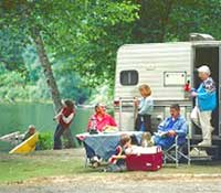
Megler Safety Rest Area is easily accessible from State Route 401. Station Camp and Fort Canby State Park are both easily acessible from U.S. Highway 101. Table 2.1, below, represents the current estimated annual visitation to these three sites.
Table 2.1 Estimated Annual Visitation and Parking Summary
| Location | Parking Spaces | Usage at Peak Times | Average Annual Visitation |
| Megler Safety Rest Area | 35 car spaces 5 RV/Bus spaces |
<20% | 441,624 people (2001) |
| Station Camp Wayside | 8 car spaces | 100% | 25,000-40,000 people (Estimated) |
| Fort Canby State Park | 290 car spaces | 85% | 761,017 people (1992-2001) |
Compiled from Fort Canby State Park Planning Project, December 2002; Megler Safety Rest Area Memo, 2003.
Regional Recreational Opportunities
The region's scenic beauty and diverse coastal habitat draw visitors for camping, clamming, oyster harvesting, bird watching, whale watching, beach combing, hiking, kite flying, kayaking, sport fishing, boating, and other water-based activities.
Fishing is a major area attraction. The Buoy Ten fishing season begins the first of August and extends through Labor Day. At Station Camp, people come to fish for sturgeon off the riprap embankment. There is a boat launch at Fort Canby which is used for public boat access to the Columbia River for fishing excursions as well as recreational boating.
Fort Canby offers hiking trails and stretches of sandy beach to explore. Vacationers have their choice of overnight accommodations at the campground or the Lighthouse Keeper's building, as well as numerous hotels, bed-and-breakfasts, and inns in the area.
Long Beach hosts a Kite Festival annually along the ocean beach, which attracts families from all over the region.
In the general area, visitors are drawn to the area to explore old military forts, museums, and interpretive centers. Other area destinations for outdoor recreation include the Willapa National Wildlife Refuge, Fort Columbia State Park, Leadbetter Point, Pacific Pines, Ocean Park, and Loomis Lake.
Tourist attractions on the Oregon side of the Columbia River include Fort Stevens State Park, Fort Clatsop National Memorial, Lewis and Clark National Wildlife Refuge, Columbia River Maritime Museum, Flavel House Museum, and the Astoria Column.
Land Ownership
Megler Safety Rest Area
(Clark's Dismal Nitch)
Washington State Department of Transportation (WSDOT) owns and manages
Megler Safety Rest Area and the right-of-way of State Route 401. The
site of the Dismal Nitch is partially located on state property and
partially located on private land owned by a local timber company.
Station Camp
Descendants of the McGowan family owns the majority of the Station Camp
site and the property north of the site. The U.S Highway 101
right-of-way is owned by WSDOT and currently runs along the shoreline of
the Columbia River. The existing wayside park along U.S. Highway 101 in
this area is owned and operated by WSPRC. WSHS is in the process of
negotiating the purchase of approximately nine acres of land for a
riverfront park and six acres for a new highway right-of-way which will
be set back from the river. The historic St. Mary's Church, which is
owned by the Roman Catholic Seattle Archdiocese is also within the
Station Camp project area.
Fort Canby State Park
(Cape Disappointment)
Approximately 1,883 acres in size, Fort Canby State Park is owned by
four different agencies. WSPRC owns the northernmost park area that
includes Beard's Hollow and North Head, and a southern parcel that
includes O'Neil Lake, McKenzie Head, and the accreted lands to the west.
The Bureau of Land Management (BLM) owns the majority of the Park's forested land and the West Beach campsites. The U.S. Army Corps of Engineers (USACE) owns the majority of the area south of McKenzie Head including the Park Hub, the Lewis and Clark Interpretive Center, and the North Jetty. The U.S. Coast Guard (USCG) owns most of the peninsula south of the existing park contact station.
Existing Interpretive Facilities
The existing interpretive facilities at the three study sites currently do not provide sufficient information to adequately convey the Lewis and Clark story. The three sites have varied levels of interpretation with Megler providing no interpretation and Fort Canby providing very good interpretation with the completion of ongoing improvements.
|
|
Megler Safety Rest Area
(Clark's Dismal Nitch)
Currently, Megler Safety Rest Area functions as a Washington State
gateway information facility and a safety rest area. Its location on
State Route 401, near the Megler-Astoria Bridge, makes it a key place to
greet and direct travelers as they enter the state.
Its facilities include a parking area, rest- rooms, covered picnic tables, a viewpoint of the Columbia River, public information kiosk, brochure dispenser, and visitor information center. To promote safe driving, this rest area allows parking for up to eight hours. Because the potable water for the restrooms is treated from a surface water source with limited capacity, the facility is closed during the winter months.
The visitor information center is run by the Washington State Tourism Office and was recently closed due to lack of funding. When in operation, the information center distributes points-of-interest brochures including "The Washington Experience of the Lewis and Clark Expedition" and a general map of the Lewis and Clark Trail in Washington State.
Most visitors are unaware of the rest area's proximity to the historic Dismal Nitch, mainly due to the lack of information and interpretation at the site addressing its Lewis and Clark history, including a most dramatic encounter with the coastal environment.
Although currently there is no interpretation at the rest area, the State of Washington Agency Assistance Team (AAT) proposes to install limited interpretation related to the Corps of Discovery's time in the area. The proposed interpretation would consist of two single interpretive panels and one kiosk which would house two interpretive panels and two orientation maps.
The proposed interpretive material at Megler Safety Rest Area would cover the dramatic story of the Corps being trapped by a torrential storm, rendering them helpless in proceeding further; interaction with Native American tribes of the region who were experts at navigating their canoes across the treacherous river; and other topics, including the story of how salmon from Megler Creek helped to sustain the starving Corps of Discovery members when they were camped here.
Station Camp
Today, a portion of Station Camp is a Washington State Park wayside stop
along the north side of U.S. Highway 101. Facilities include a small
gravel pull-off area, a picnic table, an interpretive panel, and a
deteriorating carved wood monument of Lewis and Clark. There are no
public restrooms at this location.
|
|
The existing wayside does not provide a suitable opportunity for visitors to experience the full depth of the Lewis and Clark story at this site, mostly due to a lack of land, difficult pedestrian connections, visibility to the water, and limited interpretive facilities.
The major shortcoming of this wayside is its location on the opposite side of the highway. Highway 101 severs the connection between the wayside and the Columbia River. Besides the physical obstacle of the highway, the view of the water is obstructed by the riprap embankment protecting the highway.
Due to a lack of interpretive elements and programs at the current wayside site, most visitors are unaware of this site's rich history related to the Lewis and Clark story on the lower Columbia River. Thus, one of the most important Lewis and Clark sites in the country is vastly under-interpreted.
Fort Canby State Park
(Cape Disappointment)
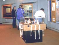
Fort Canby's Lewis and Clark Interpretive Center (LCIC) is currently
undergoing an expansion and renovation. Planned improvements include
increased exhibit space, new interpretive exhibits, an access road for
accessible parking, minor expansion of this area, and the installation
of three-phase electric utilities. Currently, Fort Canby also has
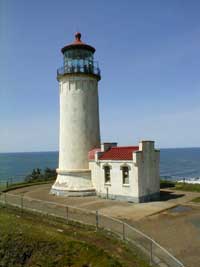
interpretive facilities related to the North Head and Cape
Disappointment Lighthouses.
Fort Canby's potential for presenting additional interpretation and programs relating to Lewis and Clark history is explored as part of the Interpretive Plan for the Long Beach Area State Parks in the Draft Interpretive Master Plan: A Plan for Interpreting Resources.
| <<< Previous | > Contents < | Next >>> |
focl/draft_boundary_study/sec2.htm
18-Jul-2003