|
National Park Service U.S. Department of the Interior Fort Clatsop National Memorial Astoria, Oregon |
 |
Draft Boundary Study and Environmental Assessment
| Issues and Considerations |
During the development of the Lower Columbia River Lewis and Clark Sites Boundary Study and Environmental Assessment, a study team was assembled of representatives from the National Park Service, Washington State Parks and Recreation Commission, Washington State Historical Society, Washington State Department of Transportation, Washington State Department of General Administration, and the project consultants. Later in the process, representatives of the Oregon Parks and Recreation Department joined the study team which brought a regional perspective to addressing lower Columbia Lewis and Clark sites in a more comprehensive manner.
Throughout the process, the study team met at least once each month to discuss project status, issues and considerations. Through these meetings, key issues and considerations were identified to be addressed through the formulation of the management alternatives. The areas defined as issues and considerations are summarized in this section.
Resource Values
The protection of resource values was identified as a critical issue at Megler Safety Rest Area and Station Camp; and is also an important consideration at Fort Canby State Park with the potential for additional development projects within the park.
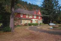 Henry McGowan residence built in 1911
|
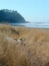
Megler Safety Rest Area
(Clark's Dismal Nitch)
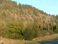
Currently, the forested hillside surrounding Megler Safety Rest Area and
the Dismal Nitch site creates an ideal setting for telling the Dismal
Nitch story. The Corps of Discovery retreated to higher ground here
while waiting out a brutal coastal storm. They survived on fish they
caught in Megler Creek, which outlets at this location today.
Station Camp
Recent archaeological research in the vicinity of Station Camp found
some European-American settlement artifacts but little evidence of the
historic Chinook village that was to the east of the Lewis and Clark
campsite.
Located within the Station Camp project area, St. Mary's Catholic Church is eligible for the National Register of Historic Places. The proposed plan for Station Camp calls for the preservation and incorporation of the church in the site development program. The historic structures and subsurface remains of the historic McGowan townsite are being evaluated for their potential eligibility for the National Historic Register for Historic Places. Outside the project area, but associated with the European-American settlement of the area after the Lewis and Clark Expedition, is the 1911 Henry McGowan house and the 1903 McGowan era building, known as "the office." They are in good historical condition and are also eligible for the National Register of Historic Places.
Another valuable resource worthy of protection is the forested hillside to the northeast of U.S. Highway 101. In addition to serving as a beautiful natural backdrop for Station Camp, the forest is considered a habitat area for marbled murrelets and bald eagles, both listed species under federal protection. Clark's journal entries describe the steep hillsides of this area, and modern-day visitors can still experience the landscape.
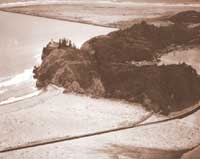
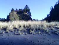
Fort Canby State Park
(Cape Disappointment)
In 1975, Cape Disappointment was registered as a historic district with
its principal components: Cape Disappointment Lighthouse, North Head
Lighthouse, Lighthouse Keeper's facility, the North Jetty, and several
gun emplacements. These historic resources are under federal protection.
Interpretive elements and programs at this site provide a great
opportunity to highlight the history of these sites along with the
prehistoric and historic sites recently identified during an
archaeological investigation of the Fort Canby area.
Another protected resource within Fort Canby State Park is the natural forest area. Located in the central portion of the park, this Sitka spruce forest provides vital habitat for many flora and fauna. This protected old-growth forest is considered the best example of outer coastal Sitka spruce forest in Washington, south of Olympic National Park. The state park includes listed species, both threatened and endangered.
Threats to the Resources
Threats to resources may come in a variety of forms, but for this analysis, the threats have been characterized and described under the subheadings of natural factors and human factors.
Natural Factors
|
|
All of the study areas are subject to the tremendous power of coastal storms. Shoreline areas and coastal roadways are frequently flooded during large storm events. On Highway 101 near Station Camp, waves from large storms have thrown huge pieces of woody debris over the riprap slope and the highway.
Since the construction of the North Jetty in 1919, the accretion and erosion of the beach sand and sediment has significantly changed the shoreline of Cape Disappointment and is expected to continue changing as weather patterns vary over the Pacific Ocean in the future.
At Fort Canby, the steady erosion of the beach in recent years has reached the outer limit of the existing campground facility. Currently, plans for relocating the campground within the park are being explored through a master planning process. The beach is expected to continue to erode and threatens the development of recreational facilities along this stretch of beach.
Human Factors
Currently, the forested hillsides surrounding the Station Camp and Dismal Nitch are privately owned. The timber could be harvested at any time by the existing property owners.
In addition, both sites have limited regulatory restrictions on land use. With no zoning covering those two sites, many types of uses could be developed on the property, which may pose a threat to the resources. These factors place both of these sites at risk of losing their naturalistic setting.
Commemoration
The United States of America is embarking on a three-year commemoration of the bicentennial of the Lewis and Clark Expedition. The Bicentennial kickoff event was held at Jefferson's Monticello in January 2003 which began a series of events across the United States.
|
|

Excitement has been building for several years in the states located along the Lewis and Clark National Historic Trail in anticipation of the actual 200th anniversary of the dates spent in each area along the 4,100 mile route. A National Bicentennial Council, for which First Lady Laura Bush serves as honorary chair, was formed to coordinate all of the states' efforts in preparation for the increased visitation to historic sites along the trail. The bicentennial effort will leave a legacy of Lewis and Clark history for the Nation.
In Washington, a group of representatives from a variety of state agencies has been meeting for more than three years to assist local communities and tribes in preparing for the bicentennial festivities. The AAT has also been coordinating the schematic design and implementation of a statewide highway interpretive wayside project, which will include more than 60 interpretive panels and 10 informational kiosks along the Lewis and Clark National Historic Trail as it passes through Washington.
Many local communities and tribal organizations in Washington and Oregon are planning and developing interpretive features and events on a local level to coincide with the day-to-day advances of the Expedition 200 years earlier. One of the major events planned in Washington State is "Destination The Pacific," which is to be held in Pacific County in November 2005. This event will be a commemoration of the Expedition's accomplishment of Jefferson's directive to reach the Pacific Ocean.
The consideration of the three study sites for inclusion in the National Park System is an important step in recognizing the significance of the events that unfolded over the 18 days the Corps spent along the north shore of the lower Columbia River in Pacific County, and in telling the story of Lewis and Clark's arrival at the Pacific Ocean. The recognition of these sites along with improvements to public access, interpretive facilities, visitor facilities, and site aesthetics will provide the American public with a glimpse of the raw emotion, determination, and fortitude of the members of this legendary Expedition. It is important that these historic sites be considered for inclusion in the National Park System as a legacy for generations to come.
Visitor Experience
The visitor experience at the Lewis and Clark sites addressed by this study is an extremely important consideration in the development and management of the properties.
|
|
With the passing of 200 years, substantial changes to the specific site features are expected in almost any situation. As a result, strong consideration of the landscape, setting, and interpretation provided to visitors at each of these sites will improve the overall experience and allow for the greatest success in interpreting the historical events which occurred at these locations. Visitor experience is influenced by many elements, including site aesthetics, views, visual characteristics, interpretation, educational information, recreational opportunities, site functions, and surrounding land use.
At the three study sites, natural and human factors have caused changes in the landscape that affect the physical integrity of the site. In contrast to some other Lewis and Clark sites, this area of the country has remained rural with beautiful landscapes and significant landforms surrounding each of the sites.
|
|
The significance of the surrounding landscape is only emphasized by the writting of William Clark's journals. As he surveyed the mouth of the lower Columbia River, Clark sighted several prominent landforms across the broad extent of the Columbia River at multiple traverse points to accurately locate Station Camp.
Clark's use of these landforms for his survey provides tremendous opportunities to interpret the experiences of the Expedition members while at these sites and the nature of scientific exploration of which Lewis and Clark were a part. Visitors would feel as though they are standing in the footsteps of Lewis and Clark as they look out over the landscape.
Providing protection of the immediately surrounding landscape to preserve the natural evergreen forests in perpetuity will provide a consistent landscape setting for the visitor.
Currently, the visitor experience is confusing and disconnected. As they are now, these three sites are not connected to each other in any way, nor to the larger Lewis and Clark story in the lower Columbia region. As a result, the story's significance is understated. To tell the dramatic story of the journey by connecting these three sites with the other Lewis and Clark sites in Washington and Oregon will be important in understanding the whole story of the conclusive westward phase of Lewis and Clark Expedition.
|
|
The visitor experience at these sites will also be influenced by the style and method of interpretation, which should accommodate learning for all ages. To engage a wider audience, multiple sensory programs and displays should be considered to provide a universal design approach to interpretation.
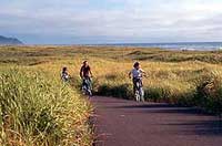
Providing safe site access for a variety of transportation modes and comfortable accommodations at specific sites for visitor functions can greatly influence the experience of the visitor. In addition, comfortable walking distances to interpretive elements and appropriate recreational activities provide visitors with opportunities to experience multiple views of surrounding landforms and varying activities for users of different age groups.
The consideration of all of these interrelated elements will provide unique and compelling experiences for a diversity of visitors at each of the sites.
Accessibility to Sites
Providing public access to all of these sites is a primary consideration in improving the sites. In addition to public access rights, each site should be designed based on universally accessible guidelines of facility construction and interpretive features.
Megler Safety Rest Area
(Clark's Dismal Nitch)
The major challenge of the site is to provide visitors visual and
physical accessibility to the historic campsite. Land acquisition would
be required to address this issue. In addition, park design,
interpretative signage, and pedestrian circulation would need to be
improved to support the goal of site accessibility. The primary
challenge of this site will be providing safe pedestrian access across
State Route 401 to the Dismal Nitch campsite.
Station Camp
Similar to the Dismal Nitch site, the two key elements for successful
public accessibility to this site are improved views and physical
connections to the Columbia River. Currently, the riprap embankment
protecting the existing highway hinders views to the Columbia River from
the north side of the highway. For the public to view or physically
access the river, visitors must cross Highway 101 in an area with poor
sight distance to reach a narrow gravel shoulder between the highway
travel lanes and the riprap embankment.
The safety concerns with this current site arrangement are significant and affect both site visitors and local citizens attempting to fish from the embankment. The embankment is also a significant barrier for people wanting to physically access the water.
In addition, the proposed park improvements should strike a balance between providing continued access to the water for fishing while not conflicting with the Lewis and Clark visitor experience.
Fort Canby State Park
(Cape Disappointment)
Currently, the Lewis and Clark Interpretive Center (LCIC) is under-going
improvements, which include interpretive exhibits, accessible ramps, and
an accessible outdoor plaza. The improvements also include the expansion
of accessible parking spaces and potential improvement to pedestrian
access from the parking lot to the interpretive center.
Access from the primary passenger vehicle parking lot to the LCIC is currently an unresolved issue. The parking is approximately 80 feet below the entry plaza outside the LCIC and is connected by a fairly steep paved trail, which does not meet accessibility guidelines.
The WSPRC is planning to construct an elevator or funicular to mitigate the accessibility issues from the lower parking lot, but design and construction is contingent upon securing funding from the state.
Tourism
Providing a comprehensive, integrated story of the Lewis and Clark Expedition throughout the region will enhance visitor experience, increase visitation, benefit the regional economy, and provide a stronger understanding of this important part of American history. The recognition of Lewis and Clark sites in Pacific County as nationally significant would provide tremendous benefits to the regional tourism industry and the local economy.
|
|
Recognition of sites west of the Astoria-Megler Bridge on the Washington side of the river could potentially draw tourists to the Long Beach Peninsula, dispersing visitors and economically benefiting the region. mproving these sites for the visiting public would provide potential for longer visits, which in turn increases expenditures on services such as meals and lodging.
A recognition of these sites would likely generate an increase in visitation both during and after the bicentennial. The increase would provide greater revenues for the local service and tourism industries.
|
|

With the anticipated increase in the area's tourism, the local economy would see increased employment opportunities as well. This employment demand in the service sector may necessitate recruiting and training staff to fill the needed positions.
A peak in visitation is expected in 2005-2006, but the level of tourism will most likely not drop back to present, pre-bicentennial levels. Enhanced park destinations along with activities and services catering to travelers will continue to draw visitors even after the commemoration. The Lewis and Clark story is truly timeless and will continue to create reoccurring and constant value for the region and the nation.
To promote the area's natural and cultural attractions and to sustain its tourism industry, planning for regional marketing efforts before and after the bicentennial will also be an important consideration.
Transportation
With the bicentennial spotlight on the region's Lewis and Clark historic sites, Pacific and Clatsop counties anticipate an increase of tourists traveling to regional attractions in passenger and recreational vehicles.
|
|
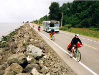
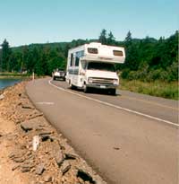
Projections from a recent Lewis and Clark Bicentennial Transportation Committee study indicate the potential addition of 1,100 vehicles each weekend day at the peak of the bicentennial. Due to the numerous related attractions in the area, visitor activity is expected to be dispersed throughout the lower Columbia region rather than concentrated at any one site.
After the bicentennial, visitation is expected to taper off but it will not drop to the pre-bicentennial volumes due to the presence of new facilities and reoccuring public intrest in the story. To accommodate the increased demand for parking during the bicentennial and thereafter, Pacific County community proponents are considering supplemental park and ride facilities and a shuttle bus program for the sites. This will be extremely important since all three sites will have limited parking capacity.
Consideration of a management structure that facilitates collaboration at a regional level would provide efficiencies in administering a regional transportation system. The regional approach to transportation solutions for the bicentennial will improve the visitor experience. Consideration of recreational vehicle, tour bus, and shuttle system requirements is an essential component in designing the improvements to both park-and-ride facilities as well as the study sites.
Site Management Considerations
Creative approaches to the management of these sites is an important consideration in the development of successful management alternatives. Public agencies are struggling to balance budgets while continuing to provide quality service.
As a result, these agencies are always looking for opportunities to provide more efficient administration through partnership agreements. At the sites being studied, two state agencies already have some ownership and maintenance responsibilities within the lower Columbia region.
Washington State Parks and Recreation Commission manages both Fort Canby State Park and Station Camp State Park wayside. WSPRC also owns Station Camp State Park, but owns only portions of Fort Canby with several federal agencies owning the remaining land in the park. Washington State Department of Transportation owns and manages the Megler Safety Rest Area.
These agencies are integral participants in the success of the management of the sites. Congress has requested that the National Park Service initiate this study. The Park Service currently has a presence across the river in Oregon at Fort Clatsop National Memorial.
Partnership arrangements regarding the management of these sites could include cooperative agreements for assistance with interpretive programming, interpretive staffing, maintenance, and administration. The proximity of the sites to other operating units at the state and federal level may provide opportunities for efficiency with travel and response to the sites.
Consideration of existing use and function of the sites in relation to current management structures will be an important factor in building consensus on the management alternatives for the sites.
| <<< Previous | > Contents < | Next >>> |
focl/draft_boundary_study/sec4.htm
21-Jul-2003