|
National Park Service U.S. Department of the Interior Fort Clatsop National Memorial Astoria, Oregon |
 |
Draft Boundary Study and Environmental Assessment
| Boundary Adjustment Criteria |
The National Park Service (NPS) is responsible for managing nationally important areas around the United States to provide for public enjoyment in such a way that will leave resources "unimpaired for the enjoyment of future generations"(1916 NPS Organic Act). Since 1872 the National Park System has grown to include more than 385 park units.
This section focuses on the NPS Boundary Adjustment Criteria as defined in the NPS Management Policies and the NPS Criteria for Parklands. The Boundary Adjustment Criteria are applied to studies of park boundary revisions to evaluate opportunities for public enjoyment, operational and management issues, protection of resources, feasibility of administration, and protection alternatives.
The Criteria for Parklands are applied to determine each site's national significance, suitability, and feasibility for inclusion within the boundary of Fort Clatsop National Memorial. The following pages summarize the evaluation of these criteria.
|
|
|
Analysis of Boundary Adjustment and Land Protection Criteria
As one of the provisions of Public Law 95-625, the National Park and Recreation Act of 1978, Congress directed that the National Park Service consider, as part of a planning process, what modifications of external boundaries might be necessary to carry out park purposes.
Subsequent to this act, Congress also passed Public Law 101-628, the Arizona Desert Wilderness Act. Section 1216 of this act directs the Secretary of the Interior to develop criteria to evaluate any proposed changes to the existing boundaries of individual park units. Section 1217 of the act calls for the NPS to consult with affected agencies and others regarding a proposed boundary change, and to provide a cost estimate of acquisition cost, if any, related to the boundary adjustment.
These legislative provisions are implemented through NPS Management Policies, which state that the NPS will conduct studies of potential boundary adjustments and may make boundary revisions:
To include significant resources or opportunities for public enjoyment related to the purposes of the park
To address operational and management issues such as boundary identification by topographic or other natural features
To protect park resources critical to fulfilling park purposes
NPS policies and Special Directive 92-11 instruct that any recommendation to expand park boundaries be preceded by determinations involving an analysis of criteria that the added lands will be feasible to administer considering size, configuration, ownership, cost, and other factors, and that other alternatives for management and resource protection have been considered and are not adequate.
The following is an analysis of the criteria for boundary adjustments as applied to the Lower Columbia Lewis and Clark Sites Boundary Study and Environmental Assessment. This analysis is included as documentation in support of the congressional legislation directing this study to examine the three Lewis and Clark sites in Washington State for their suitability and feasibility for addition to Fort Clatsop National Memorial.
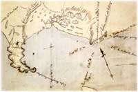
Boundary Change
|
|
The study examines four alternatives for the public use, protection, and management of the Megler Safety Rest Area, Station Camp, and Fort Canby State Park sites. If a portion or all of the sites are deemed appropriate by Congress to add to the existing boundaries of Fort Clatsop National Memorial, then authorizing legislation would be required before the National Park Service could assume management, operation, development, and protection of these sites.
For purposes of this analysis, the area under consideration at Fort Canby State Park is a 10-acre site at a prominent location on Cape Disappointment overlooking the ocean. In two of the four management alternatives that follow, the establishment of a Thomas Jefferson National Memorial within the site is proposed. Hence this concept is included in the analysis of the criteria.
Along with this authorization, appropriations from the Land and Water Conservation Fund could potentially be required at Megler Safety Rest Area and at Station Camp where the acquisition of conservation easements from "willing sellers" is a component of each of the management alternatives, except the No Action Alternative. It is assumed that if the Station Camp site and the Thomas Jefferson National Memorial site at Fort Canby State Park are authorized for addition to the Fort Clatsop National Memorial boundary, the state of Washington would transfer these sites to the National Park Service via donation. In the case of the 10-acre Thomas Jefferson National Memorial site within Fort Canby State Park, the underlying land ownership is already federal, so the land transfer would be between two federal agencies.
All three sites presented in the study, Megler Safety Rest Area (Clark's Dismal Nitch), Station Camp, and the Thomas Jefferson National Memorial component of Fort Canby State Park, are considered resources to be included for this evaluation for boundary adjustment to Fort Clatsop National Memorial. For the purposes of this analysis, it is assumed that each site is being considered separately for addition to the Fort Clatsop National Memorial, and does not necessarily, in total, conform to any one alternative presented in the study.
Significant Resources or Opportunities for Public Enjoyment Related to the Purpose of Fort Clatsop National Memorial
All three study areas provide significant opportunities for public education and enjoyment. Clark's Dismal Nitch represents the important story of the Lewis and Clark Expedition's difficulties even within mere miles of their ultimate goal. Site enhancements discussed in the management alternatives include protection of the forested setting and public access to the stream outlet into the Columbia River which provide enhanced opportunities for the public to appreciate this historic location and the stories associated with it.
Station Camp, including the funded park improvements and highway realignment by the state of Washington, provides significant enhancements for the public experience and a better understanding of the significance of this site. This includes an understanding of the key interpretive themes of "mission accomplished," "ocean in full view," Clark's survey of surrounding landforms, and the vote on the location of winter camp.
The visitor experience is further enhanced by the potential protection of the forested escarpment behind Station Camp through the purchase of a conservation easement from a willing seller.
The prospect of a Thomas Jefferson National Memorial site within Fort Canby State Park offers a fitting tribute to America's third President who had visions of a nation from "sea to shining sea." The 10-acre memorial site, which would be located on a promontory overlooking the Pacific Ocean, and a short walking distance via an accessible trail from the existing Lewis and Clark Interpretive Center, provides outstanding public opportunities to experience firsthand the magnitude of the moment for the Lewis and Clark Expedition, and to reflect on President Jefferson's vision for America.
Operational and Management Issues Related to Access and Boundary Identification by Topographic or Other Natural Features
The potential boundary change at all three sites provides the National Park Service with the prospect of manageable boundaries for satellite additions to the Fort Clatsop National Memorial. The Clark's Dismal Nitch site includes a small defined land area between the highway and the Columbia River, a small area north of the highway at the Megler Creek outlet, and a forested escarpment where a conservation easement would be acquired. Two existing property owners would be involved: the Washington State Department of Transportation and a private timber company.
Boundary identification would be relatively easy, except toward the northern portion of the easement area, where the topography slopes steeply to the north. The boundary of the site is manageable. Maintenance of the site on behalf of the NPS could involve a cooperative agreement with Washington State Parks, which manages nearby Fort Columbia State Park a few miles to the west.
The Station Camp site includes a dedicated park area between the highway and the Columbia River, a small church property, and a potential conservation easement from a willing seller on a forested escarpment of private land to the north of the highway. One private ownership interest would be involved in the easement purchase. Much like Clark's Dismal Nitch, boundary identification would be relatively easy, except toward the northern portion of the easement area, where the topography slopes steeply to the north. The boundary of the site is manageable. Maintenance of the site on behalf of the NPS could involve a cooperative agreement with Washington State Parks, which manages nearby Fort Columbia State Park.
The potential Thomas Jefferson National Memorial site within Fort Canby State Park presents few boundary or management problems. The 10-acre site can be easily established within the park, the land is already in federal ownership, and public access to the site is from a parking lot and proposed funicular from the base parking area to the Lewis and Clark Interpretive Center. NPS maintenance of the 10-acre Memorial could be assisted by Washington State Parks, which manages the surrounding Fort Canby State Park. This could be accomplished through a cooperative agreement.
Protection of National Memorial Resources and Fulfillment of Purpose of Fort Clatsop National Memorial
The potential boundary changes at Clark's Dismal Nitch and Station Camp would protect additional areas along the Columbia River in Washington State which directly relate to the Corps of Discovery experience during the winter of 1805-06. This includes sites that were mentioned in the journal and where the expedition spent significant time.
These potential additions to the National Memorial would greatly complement the theme and purpose of the park, and greatly assist in the protection of these sites for the American people and for posterity. They would protect valuable historic resources of the authentic settings of the Lewis and Clark Expedition, cultural landscapes and vistas of land and water experienced by the expedition. Additions would also protect various natural resources involving the banks of the Columbia River, riverine environs and forested uplands. The 10-acre Thomas Jefferson National Memorial site within Fort Canby State Park is already protected by Washington State Parks, and the site would remain protected under NPS management if authorized by Congress.
|
|
Feasibility to Administer the Lands Added through Boundary Adjustment
The proposed addition is highly feasible for the NPS to manage. The main park headquarters is just across the Columbia River in nearby Astoria, Oregon. Also, cooperative management arrangements with Washington State Parks could involve agreements whereby Washington State Parks assists the NPS in site maintenance, given the proximity of state park maintenance facilities at Fort Columbia and Fort Canby to each of the three sites. Sharing of interpretive staff among the sites has always been a consideration, including staffing during the bicentennial of the Lewis and Clark Expedition. Therefore, adding NPS interpretive staff to the sites during peak visitor periods, along with coordination on interpretive programming and exhibits has always been envisioned.
Protection Alternatives Considered
The study includes four alternatives, each calling for varying degrees of cooperation with other entities, including Washington and Oregon State Parks, to protect site resources found at each of the three sites. The study presents several strategies addressing both the protection and public use of resources. Two of the four management alternatives presented would not involve a boundary change or direct NPS management of the sites. All three sites are of national importance and directly relate to the core mission of Fort Clatsop National Memorial.
Proposed Additions to the Fort Clatsop National Memorial Boundary and Other Adjustments
Under the study findings, various alternatives involve different levels of NPS involvement and needs for boundary adjustments through donation or use of funds from the Land and Water Conservation Fund. Even under those alternatives calling for additions to the National Memorial, all three sites involve donation of land. Two sites may involve the use of the Land and Water Conservation Funds for the purchase of conservation easements or other appropriate interests from two willing sellers, one at each site. The preliminary estimate of the cost of the easements at these two sites has yet to be finalized, but would be expected to total under $3,000,000 between the two properties.
Criteria for Parklands
Public Law 105-391 (1998) outlines the criteria by which areas are evaluated for their potential inclusion in the National Park System. These criteria have been applied to analyze and determine the eligibility of each of the three sites. As directed by Congress, these sites have been evaluated for their national significance, suitability, and feasibility for possible inclusion in Fort Clatsop National Memorial.
NPS Management Policies have been applied to determine whether the Lower Columbia River Lewis and Clark sites qualify for inclusion as potential additions to Fort Clatsop National Memorial. The sites have been evaluated according to law and policy and are described as follows:
National Significance
|
|
The Lower Columbia River Lewis and Clark sites included in this study are significant campsites near the western terminus of the Lewis and Clark National Historic Trail. These sites provide the background and opportunity to interpret the culmination of the Corps of Discovery's expedition across the continent to reach the Pacific Ocean.
The experiences of the Lewis and Clark Expedition at these sites were some of the most dramatic and sensational of their entire voyage. They experienced a wide range of emotions including: despair at being pinned against the cliffs and rocky shore for several days at Clark's Dismal Nitch, unable to proceed; elation at reaching the "butifull Sand beech" at Station Camp, with their first full view of the Pacific Ocean; the spirit of democracy in the vote by all members of the Corps on the location of winter camp, and satisfaction and fulfillment in listening to the waves crashing against the rocks and walking along the shores of the Pacific Ocean.
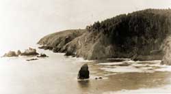
The members of the Expedition experienced despair and fear for their well-being while trapped by a storm at this site located at present-day Megler Safety Rest Area. William Clark called this location the "dismal nitich." They remained camped in this vicinity for six days, spending the nights of November 10-14, 1805 waiting for the storm to relent.
During this storm, members of the Expedition tried several times unsuccessfully to navigate through the large waves crashing towards them from the southwest. After six days of stormy weather, the wind and rain ceased and allowed the Expedition to paddle their canoes around "Point Distress" (Point Ellice) to a place they described as a beautiful sandy beach.
The surrounding landforms, including the Megler Creek outlet, retain integrity in relation to the historic and natural setting. Broad views of the Columbia River and the surrounding landscape can be enjoyed at this site.
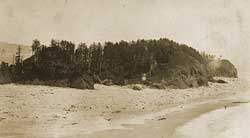
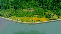
Station Camp is the most significant campsite along the lower Columbia River. Because of the events that occurred here, it is one of the most important camp sites of the entire journey. The members of the Expedition were at this site for more than ten days, from November 15-25, 1805, while conducting two excursions to investigate the coastline and determine an appropriate location for winter camp.
Station Camp is the place where the Corps had their first full view of the Pacific Ocean. Reaching this point in the journey brought much elation and satisfaction to the Expedition members. Sergeant Patrick Gass referred to this location as the "end of our voyage."
Station Camp was named for the traverse and stations when Captain Clark surveyed the site. Clark's survey is significant because the level of detail and number of sightings taken were performed at only a handful of sites along the entire journey.
Station Camp is also the site of an informal vote conducted by the leaders of the military expedition to determine the preferred location for winter camp.
By successfully reaching the Pacific Ocean, the Corps of Discovery accomplished President Thomas Jefferson's directive and helped the United States of America claim land west of the newly acquired Louisiana Purchase.
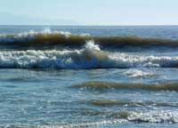
Cape Disappointment was the last piece of land explored as the Expedition reached the Pacific Ocean. Expedition members were finally able to touch the waters of the Pacific Ocean and see and hear the waves crashing onto the rocks and cliffs along the western shore of Cape Disappointment.
On November 18-19, 1805, Clark and 11 men hiked by land through present-day Fort Canby State Park on a two-day excursion from Station Camp to investigate the coastline. They trekked from Baker Bay across the cape, down through a wooded hollow to the ocean shores and north along the sandy beach of the Long Beach Peninsula.
Clark's party camped for one night on the beach near McKenzie Head. This is one of the few campsites currently situated on public land on the Pacific Ocean.
Cape Disappointment retains a high degree of integrity as a relatively unspoiled example of a natural and cultural resource associated with the Corps of Discovery's experience along the lower Columbia.
A portion of the landscape within the park remains relatively unspoiled and includes old-growth trees as well as significant landforms that Clark describes in his journals. In the park, one can imagine the Expedition coming in contact with those features 200 years ago. Although, there are some changes in the landscape, including the physical changes in the shoreline due to accretion after the construction of the jetties at the mouth of the Columbia River, the major landmarks observed by the expedition are still evident today from the site.
Summary of National Significance
All three sites offer excellent opportunities for public education, public use, and enjoyment.
Station Camp, under the name "Lewis and Clark Campsite," and Cape Disappointment at Fort Canby State Park are two of 89 certified sites on the Lewis and Clark National Historic Trail. (Certification of sites is described in the Cultural Resources portion of the Affected Environment section.)
In conclusion, all three sites are of national importance and reflect many of the attributes as found by Lewis and Clark. The sites serve to fully complement the significance of the winter encampment at Fort Clatsop.
Suitability
|
|
A portion of the Dismal Nitch site is in public ownership, but is not managed by a land management agency. The site is used currently as a highway safety rest area and managed by WSDOT. Portions of the Dismal Nitch campsite are not adequately protected for public use at this time since they are privately owned. No interpretation is currently provided at this site.
The importance of the Station Camp site is understood by the declaration of Sergeant Patrick Gass that this site represented the "end of our voyage," the democratic vote on the location of winter camp, and Clark's detailed survey of the site and surrounding landforms. These events have been recognized at this time through a small wayside exhibit at this site owned and managed by WSPRC. However, there is a strong need to provide more extensive interpretation and commemoration about this significant history. This interpretation would be the most effective and meaningful if located specifically at the site.
Station Camp is not adequately protected for public enjoyment at this time. Except for the small interpretive wayside park owned by the WSPRC, the remainder of the site is privately owned. Negotiations are underway for the state of Washington to purchase the property from the private property owner.
At Fort Canby State Park, WSPRC is currently expanding and renovating the Lewis and Clark Interpretive Center, with new exhibits focusing on the Expedition's 18 days in Pacific County. Additional site specific interpretation at the three Lower Columbia Lewis and Clark sites would greatly enhance this overview.
Fort Canby State Park is adequately protected for public enjoyment. More than 1,883 acres are being managed by the WSPRC, with land ownership of this acreage split between WSPRC, USCG, USACE, and the BLM.
Summary of Suitability
The Lewis and Clark experience on the lower Columbia River and the accomplishment of reaching the Pacific Ocean could be enhanced through the addition of these three sites to Fort Clatsop National Memorial. The addition of these three sites would add to the public's understanding of the Corps of Discovery experience along the lower Columbia. The addition of these sites would also afford additional protection to important historic resources.
Feasibility
|
|
At Megler Safety Rest Area (Clark's Dismal Nitch), a boundary can be drawn of sufficient size and configuration to ensure long-term preservation of the resources and to accommodate public use. It is likely the boundary could be drawn to maximize protection of the resources and minimize physical land ownership to only areas requiring public access.
There is potential for efficient administration at a reasonable cost with the determination of an appropriate method for addressing the need for improvements to the potable water system at the site.
Private ownership of land within the proposed boundary can be accommodated through a conservation easement without fee title acquisition while still realizing resource protection and visitor use goals.
Acquisition costs can be minimized or negated through donation by the state or through a cooperating agreement with the Washington State Department of Transportation.
Access to the site along State Route 401 and via existing driveways and parking is easily accomplished. Threats to the resources include barriers to fish passage and potential timber harvesting around the site.
At Station Camp, a boundary can be drawn of sufficient size and configuration to ensure long-term preservation of the resources and to accommodate public use.
It is likely the boundary could be drawn to maximize protection of the resources and minimize physical land ownership to only areas requiring public access. There is a potential for efficient administration at a reasonable cost through administration by Fort Clatsop National Memorial or cooperative agreement with WSPRC.
Private ownership of land within the proposed boundary can be accommodated through a conservation easement while still realizing resource protection and visitor use goals. Acquisition costs can be minimized or negated through a land donation by the state.
Access to the site along the existing U.S. Highway 101 can be easily accomplished. Threats to the resources are minimal at this time since the private owners have been stewards of the land for more than 150 years. However, the site is still primarily under private ownership with county land use standards currently allowing a variety of uses for the property.
At Fort Canby State Park, a boundary can be drawn of sufficient size and configuration to ensure long term preservation of the resources and to accommodate public use.
There is a potential for efficient administration at a reasonable cost, especially through cooperating agreements with the WSPRC and the three federal agencies owning land in the park. There is no private ownership of land within Fort Canby State Park.
Acquisition costs can be minimized or negated through a land exchange between public agencies or through a cooperating agreement with WSPRC, BLM, USCG, and USACE.
Access to the site along U.S. Highway 100 into existing park roads and parking lots is easily accomplished, but could be enhanced to improve accessibility to specific areas of the park.
Threats to the resources are minimal since the park is currently managed by WSPRC and protected through ownership by WSPRC, BLM, USCG, and USACE.
Summary of Feasibility
In conclusion, Megler Safety Rest Area (Clark's Dismal Nitch), Station Camp, and Fort Canby State Park (Cape Disappointment) have the sufficient size and configuration to ensure long term preservation of the resources and meet the criterion of feasibility to be added to Fort Clatsop National Memorial.
The addition of these sites would round out the story of the end of the Corps journey and make compelling new additions to the national memorial.
| <<< Previous | > Contents < | Next >>> |
focl/draft_boundary_study/sec5.htm
21-Jul-2003