|
National Park Service U.S. Department of the Interior Fort Clatsop National Memorial Astoria, Oregon |
 |
Draft Boundary Study and Environmental Assessment
| Management Alternatives |
The four management alternatives related to the three lower Columbia Lewis and Clark sites analyzed in this study include:
Alternative A — No Action: Current Site Management Continues
Alternative B — Lewis and Clark Washington State Park Sites
Alternative C — Expansion of National Memorial and Washington State Park Sites
Alternative D — Lewis and Clark National and State Historical Park
Each of these alternatives is described in detail in this section, including aspects related to site management, resource protection, visitor experience, cost considerations, and feasibility.
Elements Common to All Alternatives
Alternative A assumes a minimal level of improvement to the existing Station Camp State Park wayside in its current location north of the existing highway, which would not be realigned. The remainder of the three management alternatives include similar development assumptions for the Station Camp site, including expanded services. Alternatives B, C, and D assume that the state highway would be realigned and an expanded riverfront park would be created between the new highway alignment and the Columbia River to commemorate the significant history of the Lewis and Clark Expedition related to the site. In addition, St. Mary's Church would continue to be privately owned and managed by the Catholic Archdiocese of Seattle.
Public transportation services between various lower Columbia Lewis and Clark sites in both Washington and Oregon have been proposed by regional transportation providers. This is common to all alternatives and the costs associated with these operations have therefore not been included in the cost estimates provided in this study.
In all alternatives, the National Park Service (NPS) would provide programmatic assistance to these sites, including the potential development of wayside exhibits, contributions of seasonal interpretive staff, and support for special programs and events during the bicentennial. The level of participation by the NPS will vary with each alternative.
All alternatives include a recommendation to add Megler Safety Rest Area (Clark's Dismal Nitch) to the list of officially certified historic sites on the Lewis and Clark National Historic Trail.
Management Alternative A: No Action
Current Site Management Continues
Under Alternative A, the "No Action" alternative, the current ownership and management structure for all three sites would be maintained with no change.
Megler Safety Rest
Area
(Clark's Dismal Nitch)
General Description of the Management Alternative
Megler Safety Rest Area would continue to be owned and managed by
WSDOT as a safety rest area. The lands surrounding the Megler Safety
Rest Area, including the site of the Dismal Nitch experience described
in the Lewis and Clark journals, would continue to be privately
owned.
|
|
Site Management
Megler Safety Rest Area is currently managed by WSDOT as a safety rest
area for the traveling public and, under this alternative, WSDOT
ownership would continue. The privately owned land to the west and
northwest of the safety rest area would continue to be managed by the
private owner. Most of the private land surrounding the site is owned by
a timber company and at least some of the site would likely be harvested
at some point in the future when the timber matures. The safety rest
area would continue to provide seasonal service, with restrooms closing
seasonally from November 30th to March 1st due to
water treatment issues.
Resource Protection
Resource protection at the site of the Dismal Nitch is limited. While
WSDOT owns Megler Safety Rest Area, the State Department of
Transportation is not considered a land management agency and has
limited policies regarding the protection of natural and cultural
resources.
Protection measures for the private land that encompasses the historic Dismal Nitch are currently state and local laws governing forest practices and the federal Endangered Species Act.
Visitor Experience
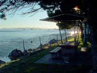
At the Dismal Nitch site and specifically at the Megler Safety Rest
Area, visitor experience is limited in relation to the Lewis and Clark
story. The safety rest area does provide essential services such as
parking for up to 30 vehicles, restrooms, and picnic tables, but
currently lacks any interpretation or design elements relating to the
Lewis and Clark story. There are plans to add orientation and
interpretive panels featuring the Lewis and Clark Expedition as part of
a statewide interpretive wayside project.
Cost Considerations
No costs for land acquisition are expected under this alternative since
the site would remain under state ownership. No additional permanent or
temporary staffing or development costs are expected under this
alternative.
WSDOT has investigated alternative water supply options in past years with no reasonable cost solution being identified. As a result, closure of the restrooms is expected to continue indefinitely until a solution is identified. Any future costs for an alternative water supply system would likely be significant considering the constraints of the site.
Station Camp State Park
General Description of the Management Alternative
Station Camp State Park would continue to be owned and managed by the
WSPRC as a small interpretive wayside off of the existing alignment of
Highway 101. With the potential for site improvements, the existing park
would provide better services to the public. The land around the wayside
would continue to be held in private ownership.
|
|
Site Management
Station Camp State Park would continue to be owned and managed by the
WSPRC as a small wayside park along Highway 101. The private property
that encompasses the remainder of historic Station Camp site would
continue to be privately owned. Limited site improvements to the
existing park would be considered as an alternative to moving the
highway and creating a riverfront park.
It is assumed the site improvements to the existing park would not be on as large a scale as the other management alternatives, although a primary goal would be to provide additional services and improved access to the Station Camp site.
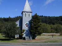
In addition, St. Mary's Church would continue to be privately owned and managed by the Catholic Archdiocese of Seattle. This action is common to all of the alternatives. Neither of these private ownership groups appear to have any plans for major changes in the management or use of the private property. However, the opportunity always exists, and changes in use could be substantial given Pacific County development allowances.
Resource Protection
Station Camp has limited protection of resources since all but one acre
of the property in the vicinity of the historic Station Camp site is
privately owned.
There is no local zoning ordinance that governs the land use in this part of Pacific County, hence the surrounding private land could potentially be developed in a variety of uses. While the site has limited protections, it has been owned by the same family for more than 150 years. This family has a personal history with the land and has provided good stewardship of the property for the tenure of its ownership. Pacific County does have a Shoreline Master Program that governs uses and setbacks from the Columbia River.
Visitor Experience
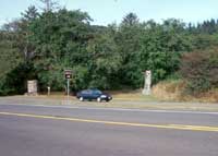
At Station Camp State Park, the facilities are limited. The one-acre
park currently includes an undefined gravel area for parking five or six
vehicles, an interpretive sign, picnic table, and carved wood statue of
Lewis and Clark.
Potential park improvements may include visitor amenities such as parking, safe vehicular access to the highway, additional interpretation, and possibly a comfort station. The park would be in its current location across the highway from the Columbia River. The visitors would have no safe route to get closer to the shoreline and experience the river, severely limiting the visitor experience of the park and reducing the direct connection to the Lewis and Clark story.
Cost Considerations
Since the existing state ownership would continue at the site, no costs
for land acquisition are expected for the federal government. The
funding for compliance, design, and construction of a park at Station
Camp is already appropriated at the state level. For improvements to a
small scale wayside and a slight shift of the highway to improve safety
conditions, estimated costs are $1,200,000 to $2,000,000.
No additional permanent staff or development costs are expected under this alternative for the federal government. Additional temporary staffing of interpretive rangers through Fort Clatsop National Memorial could occur at any time under a cooperative agreement with Washington State Parks to assist with interpretive staffing, particularly during the bicentennial years of 2005 and 2006. The additional annual staffing costs for NPS to support WSPRC at Station Camp for the years 2005 and 2006 are estimated to be $8,150.
Fort Canby State Park
(Cape Disappointment)
General Description of the Management Alternative
Fort Canby State Park would continue to be managed by the WSPRC with
underlying ownership to be maintained. The ownership of the park lands
includes the U.S. Army Corps of Engineers (USACE), Bureau of Land
Management (BLM), U.S. Coast Guard (USCG), and WSPRC. Improvements by
WSPRC would continue in preparation for the Lewis and Clark Bicentennial
and include an expansion to the Lewis and Clark Interpretive Center, new
indoor and outdoor interpretive exhibits, and improved access from the
parking lot to the LCIC.
|
|
Site Management
Fort Canby State Park would continue to be managed by the WSPRC as a
major state park destination for visitors to this area. The park will
likely go through some changes in operations and management in the next
few years in preparation for the Lewis and Clark Bicentennial. The WSPRC
would continue to be the primary manager and operator of the park with
assistance from the NPS with interpretive programming and staffing.
Resource Protection
Fort Canby State Park currently has the highest level of resource
protection of the three sites since it is entirely owned by public
agencies. Three of the four agencies owning property within the park
boundaries are land management agencies including the primary manager of
the property, WSPRC. As a result, the parklands have strict policies on
resource protection, which limit any threats to the resources at this
site.
Visitor Experience
Fort Canby State Park provides the best visitor experience of the three
sites since it is operated as one of the premier state parks in the
state of Washington. The park has camping, a boat launch, day use areas,
beach areas, lighthouses, trails, the Lewis and Clark Interpretive
Center, and other facilities. Visitors have a multitude of experiences
to select from at this park.
The Lewis and Clark Interpretive Center is currently being expanded and renovated with new interpretive exhibits in preparation for the bicentennial. One limiting factor at the LCIC is the number of parking spaces and the location of parking in relation to the LCIC. Parking is 80 feet below the interpretive center and requires a strenuous walk to the building. WSPRC is seeking funding for an elevator or funicular system to provide better access to the LCIC and improve the visitor experience.
Cost Considerations
No costs for land acquisition are expected under this alternative
since the site would remain under the current state and federal
ownership.
No additional permanent staff or development costs are expected under this alternative. Additional temporary staffing of interpretive rangers through Fort Clatsop National Memorial could occur at anytime under a cooperative agreement with Washington State Parks to assist with interpretive staffing, particularly during the bicentennial years of 2005 and 2006. The additional annual staffing costs for NPS to support WSPRC at Fort Canby State Park for the years 2005 and 2006 are estimated to be $29,650.
Washington State Parks and Recreation Commission is investing more than $3,000,000 in capital improvements associated with the Lewis and Clark Interpretive Center at the park.
Alternative B: Lewis and Clark Washington State Park Sites
Under Alternative B, the ownership and management of the Megler Safety Rest Area would change to a state park designation and Station Camp State Park would be expanded. Fort Canby State Park ownership and management would remain the same. The land required to expand Megler and Station Camp would be acquired from the surrounding private land owners.
Megler Safety Rest
Area
(Clark's Dismal Nitch)
General Description of the Management Alternative
In this alternative, Megler Safety Rest Area would continue under WSDOT
ownership and management. It would be enveloped within a larger boundary
named Clark's Dismal Nitch State Park, which would be managed by the
WSPRC (See Figure 6.1). The WSPRC would acquire the property northwest
of the safety rest area as a land base for the protection and
interpretation of the Dismal Nitch story.
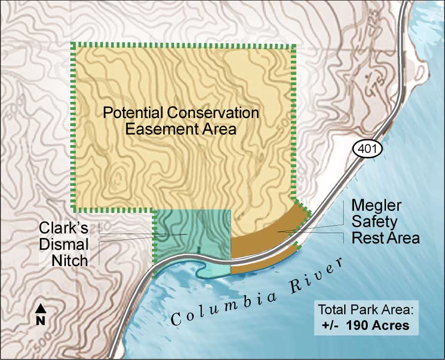
Figure 6.1 Boundary of Clark's Dismal Nitch State Park
(Typical of Alternatives B and C)
(click on image for an
enlargement in a new window)
The WSPRC would also consider obtaining a conservation easement over the land to the north of the Dismal Nitch site and safety rest area through an agreement with the private owner to protect the scenic qualities, historic, and natural values of the land. This area includes a portion of the Megler Creek watershed which is part of the history of the Dismal Nitch.
Site Management
In this alternative, Megler Safety Rest Area would continue under
WSDOT ownership and management. It would be enveloped within a larger boundary
named Clark's Dismal Nitch State Park, which would be managed by the WSPRC.
The WSPRC would acquire and manage the property northwest of the safety rest
area as a land base for the protection and interpretation of the Dismal Nitch story.
WSDOT and WSPRC would develop
a cooperative agreement regarding the management of the joint use property.
The issues related to potable water treatment would be
studied further so year-round service could be
provided in the future.
Resource Protection
The Megler Safety Rest Area is currently owned by WSDOT, which puts the
land in the public domain, although WSDOT is not considered a land
management agency and has limited policies regarding the protection of
natural and cultural resources. As a result, this alternative includes
the proposal for a cooperative agreement with the WSPRC regarding use
and management of the rest area and the remainder of the WSDOT property.
WSPRC would also acquire additional property northwest of the safety rest area at the historic Dismal Nitch to protect the natural and cultural resources associated with the site. This property acquisition along with the agreement with WSDOT on the safety rest area property would essentially create Clark's Dismal Nitch State Park.
In addition, the WSPRC would consider obtaining a conservation easement over the land surrounding the historic Dismal Nitch to protect the historic, natural, and scenic qualities of the property. These actions would greatly improve the protection of both cultural and natural resources of the area known as the Dismal Nitch.
Preserving this landscape setting from potential timber harvest can be achieved through a conservation easement over the surrounding private property. In addition to protecting the forested hillside as a visual amenity, a conservation easement would protect slope stability, water quality of the stream and its watershed, and habitat for flora and fauna.
Visitor Experience
Under this alternative, the Megler site would continue to be operated as
a safety rest area with the same basic services. To enhance the visitor
experience, opportunities to walk to the specific area believed to be
the site of the Dismal Nitch would be provided along with interpretation
relating to the Lewis and Clark story at the Dismal Nitch.
Consideration of safe pedestrian access alternatives to the Dismal Nitch would be an essential part of the site design to address potential solutions for pedestrians crossing State Route 401.
The interpretive improvements would include interpretive panels, orientation panels, and interpretive trails which tie thematically with interpretation provided at other Lewis and Clark sites managed by the WSPRC. The visitor experience would also be enhanced through the provision of guided interpretive tours provided by WSPRC or NPS rangers at peak visitation periods. The improvement of the visitor experience would also be guaranteed to last in perpetuity with the protection of the landscape as it currently exists surrounding the site.
Cost Considerations
No costs for land acquisition would be expected by the federal
government under this alternative since the site will be under state
ownership. State costs for land acquisition would be expected to total
between $250,000 to $1,000,000 for Clark's Dismal Nitch State Park with
the potential for approximately $750,000 to $1,500,000 in development
costs for trails, interpretive exhibits, and other improvements. This
estimate would also cover the cost of developing an alternative water
system, as well as culvert replacement, and stream restoration at Megler
Creek. The acquisition costs include the potential to acquire a
conservation easement on lands surrounding the publicly acquired land.
No additional full-time permanent staffing would be expected under this alternative, although additional part-time staffing for interpretation and maintenance would be necessary at the state level. Additional seasonal staffing of interpretive rangers also would be used as funding permits through Fort Clatsop National Memorial under a cooperative agreement with Washington State Parks to assist with interpretive staffing during the bicentennial years of 2005 and 2006. The additional annual staffing costs for the NPS in the years 2005 and 2006 are estimated to be $8,150.
Feasibility
This alternative for Megler Safety Rest Area and Clark's Dismal Nitch
would be feasible, but would also be subject to the following
contingencies:
WSDOT and WSPRC would enter into a cooperative agreement based on the association of Clark's Dismal Nitch State Park with the Megler Safety Rest Area;
WSPRC approval of the acquisition through "willing seller" negotiations, creation and inclusion of Clark's Dismal Nitch State Park into the State Park System; and
WSPRC approval to obtain a conservation easement or use agreement through "willing seller" negotiations on the private lands surrounding Clark's Dismal Nitch State Park.
Station Camp State Park
General Description of the Management Alternative
The Station Camp site would be improved through the realignment of the
highway to create a riverfront park named Station Camp State Park. The
site would incorporate improvements such as parking, safe
ingress/egress, a comfort station, pedestrian walkways separated from
vehicular access, interpretation of the history of the site, and
viewpoints of the surrounding landscape (See Appendix C). The park would
be owned and managed by the WSPRC. In addition, WSPRC would consider
obtaining a conservation easement over the remainder of the private land
to protect the scenic, historic, and natural qualities surrounding the
site (See Figure 6.2).
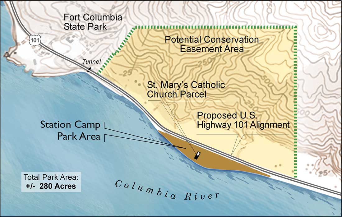
Figure 6.2 Boundary of Station Camp (Typical of
Alternatives B, C and D)
(click on image for an enlargement in a
new window)
|
|
Site Management
Station Camp State Park would continue to be managed by the WSPRC. The
improved park site would be located between the realigned highway and
the Columbia River shoreline. The site would provide improved visitor
access, a comfort station, enhanced interpretation of the Lewis and
Clark story at Station Camp, and viewpoints of the surrounding
landscape. Pedestrian access to Fort Columbia State Park from Station
Camp is also being explored through a trail link.
The privately owned land surrounding the site on the west, north, and east would continue to be managed by the current owners, with an easement granted to state parks to preserve the natural and scenic qualities of the backdrop of Station Camp. St. Mary's Church would continue to be privately owned and managed by the Catholic Archdiocese of Seattle. The church and the WSPRC would establish a joint use agreement for use of the parking, comfort station, and public gathering spaces.
Resource Protection
This alternative for Station Camp State Park would provide much greater
long-term resource protection. Approximately nine acres of property
would be transferred to WSPRC from private ownership for the purpose of
developing a riverfront park to commemorate the history of the Corps of
Discovery at the site. This property would then be protected by many of
the standard resource protection policies associated with public lands.
In addition, the WSPRC would consider obtaining a conservation easement through "willing seller" negotiations over a portion of the remaining private property surrounding the park site to protect the historic, natural, and scenic qualities of the property as a backdrop to the park.
|
|
Visitor Experience
Under this alternative, the visitor experience at Station Camp State
Park would be greatly improved from the existing state park wayside. The
development of the riverfront park would enhance the visitor experience
at the site by providing parking, improved egress/ingress, a comfort
station, safe and direct access to the Columbia River, enhanced
interpretation of the Lewis and Clark story, group gathering areas, and
viewpoints so visitors can enjoy the surrounding landscape.
WSPRC and NPS interpreters, along with commercial tours, historic groups, and others would be able to utilize areas on site for interpretive programs. The site would be designed for maximum accessibility to accommodate a variety of users including children, school groups, adults, senior citizens, and people with disabilities. It is expected the site would also accommodate anglers who have historically fished from the banks of the Columbia River at this site.
The primary interpretive themes proposed for this site include the following:
Jefferson's Vision
"Full View of the Ocean," by the Corps of Discovery (Mission Accomplished)
Clark's survey of Station Camp
Station Camp vote on the location of winter camp
Expedition relations with the Chinook Tribe and other native people
Secondary themes include:
McGowan family history, including the canneries
St. Mary's Church history
Natural ecology of the area
Cost Considerations
No costs for land acquisition are expected by the federal government
under this alternative since the site would be under state ownership.
State funding for land acquisition has already been appropriated for the
Station Camp park project. Additional funding would be needed to acquire
a conservation easement on lands surrounding the publicly acquired land.
This cost could be up to approximately $1,000,000 depending on the
extent of the easement boundary.
No additional permanent NPS staff or development costs are expected under this alternative. Additional seasonal staffing of interpretive rangers through Fort Clatsop National Memorial is expected, under a cooperative agreement with WSPRC, to assist with staffing during the bicentennial years of 2005 and 2006. The additional annual staffing costs for the NPS in the years 2005 and 2006 are estimated to be $8,150.
Feasibility
This management alternative would be feasible although the proposed
improvements at Station Camp rely on a successful "willing seller"
negotiation to acquire the additional property necessary for the
realignment of the highway and development of the park. This alternative
would be contingent on:
WSPRC approval of the relinquishment of the existing park wayside and acceptance of the developed Station Camp State Park site, and
WSPRC approval of obtaining a conservation easement or use agreement on the private lands surrounding Station Camp State Park to protect the scenic backdrop.
The funding for acquisition, design, and construction of the highway realignment and park development has already been appropriated at the state level.
Fort Canby State Park
(Cape Disappointment)
General Description of the Management Alternative
Fort Canby State Park would continue to be managed by the WSPRC under
the current land ownership configuration which includes the WSPRC, BLM,
USACE, and USCG. Efforts would continue on the improvement of the park
in preparation for the Lewis and Clark Bicentennial. These include an
expansion to the Lewis and Clark Interpretive Center, new indoor and
outdoor interpretive exhibits, and improved access from the parking lot
to the interpretive center.
|
|
Site Management
Fort Canby State Park would continue to be managed by the WSPRC as a
major state park and destination for visitors to this area. The park
will likely go through some changes in operations and management in the
next few years in preparation for the Lewis and Clark Bicentennial, but
WSPRC would continue as the primary manager and operator of the park
with assistance from the NPS on interpretive programming.
Resource Protection
Fort Canby State Park would maintain current levels of resource
protection since it is already entirely owned by public agencies. Three
of the four agencies owning property within the park boundaries are land
management agencies including the primary manager of the property,
WSPRC. As a result, the park lands have strict policies on resource
protection which limits any threats to the resources at this site.
|
|
Visitor Experience
Fort Canby State Park provides a quality visitor experience because of
its size and operation. Amenities at the park include camping, a boat
launch, day use areas, beach areas, lighthouses, trails, the Lewis and
Clark Interpretive Center, and other features. Visitors have a multitude
of experiences to select from at this park.
The LCIC is currently being expanded and renovated with new interpretive exhibits in preparation of the bicentennial. One current limitation to the experience of visiting the LCIC is the limited number of parking spaces and the location of parking in relation to the LCIC. The parking is 80 feet below the interpretive center and requires a strenuous walk to the building. WSPRC is seeking funding for an elevator or funicular system to provide better access to the LCIC and improve the visitor experience.
Cost Considerations
No costs for land acquisition are expected by the federal government
under this alternative since the site would remain under the current
state and federal ownership. No additional permanent staff or
development costs would be expected under this alternative. Although,
additional seasonal staffing of interpretive rangers through Fort
Clatsop National Memorial is expected under a cooperative agreement with
Washington State Parks to assist with interpretive staffing during the
bicentennial years of 2005 and 2006. The additional annual staffing
costs for the NPS for the years 2005 and 2006 are estimated to be
$29,650. WSPRC is currently investing more than $3,000,000 in capital
improvements associated with the Lewis and Clark Interpretive Center at
Fort Canby.
Feasibility
This alternative for Fort Canby State Park would be feasible since no
change of management is required. Some coordination with the NPS would
be needed to provide an integrated visitor experience for all of the
sites in the lower Columbia region, including Fort Clatsop National
Memorial.
Alternative C:
Expansion of National Memorial and Washington State Park Sites
Generally, Alternative C focuses on the expanded management of all three areas. There are three significant elements in this alternative. First, designation of Clark's Dismal Nitch State Park by the state of Washington; secondly, the proposed addition of Station Camp to Fort Clatsop National Memorial; and third, the creation of the Thomas Jefferson National Memorial (TJNM) within Fort Canby State Park as a second addition to Fort Clatsop National Memorial.
Megler Safety Rest
Area
(Clark's Dismal Nitch)
General Description of the Management Alternative
In this alternative, Megler Safety Rest Area would continue under WSDOT
ownership and management but would be enveloped within a larger boundary
named Clark's Dismal Nitch State Park, managed by the WSPRC (See Figure
6.1). The WSPRC would acquire the property northwest of the safety rest
area as a land base for the protection and interpretation of the Dismal
Nitch story.
The WSPRC would also consider obtaining a conservation easement over the land to the north through an agreement with the private owner to protect the long-term scenic, historic, and natural values of the land. This area would include a portion of the Megler Creek watershed, which is part of the history of the Dismal Nitch.
|
|
Site Management
In this alternative, Megler Safety Rest Area would continue under WSDOT
ownership and management, but would be enveloped within a larger
boundary named Clark's Dismal Nitch State Park, and managed by the
WSPRC. The WSPRC would acquire and manage the property northwest of the
rest area as a land base for the protection and interpretation of the
Dismal Nitch story. The safety rest area would continue to provide
seasonal service, closing in the winter months due to potable water
treatment issues.
Resource Protection
The Megler Safety Rest Area is currently owned by WSDOT, which places
the land in the public domain, although WSDOT is not considered a land
management agency and has limited policies regarding the protection of
natural and cultural resources. As a result, this alternative includes
the proposal for a cooperative agreement with the WSPRC regarding use
and management of the rest area and the remainder of the WSDOT
property.
WSPRC would also acquire additional property northwest of the rest area at the approximate location of historic Dismal Nitch to protect the natural and cultural resources associated with the Lewis and Clark story. This property acquisition, along with the agreement with WSDOT on the safety rest area property, essentially creates Clark's Dismal Nitch State Park.
In addition, the WSPRC would consider obtaining a conservation easement over the land surrounding the historic Dismal Nitch to protect the historic, natural, cultural, and scenic qualities of the property.
Preserving this landscape setting from potential timber harvest could be achieved through a conservation easement over the surrounding private property. In addition to protecting the forested hillside as a visual amenity, a conservation easement would protect slope stability, water quality of the stream and its watershed, and habitat for flora and fauna.
|
|
Visitor Experience
Under this alternative, the Megler site would continue to be operated as
a safety rest area with the same basic services. To enhance the visitor
experience, opportunities to walk to the specific area believed to be
the site of the Dismal Nitch would be provided along with interpretation
relating to the Lewis and Clark story at the Dismal Nitch.
Consideration of safe pedestrian access alternatives to the Dismal Nitch would be an essential part of the site design to address potential solutions for pedestrians crossing State Route 401. The interpretive improvements would include interpretive panels, orientation panels, and interpretive trails which tie thematically with interpretation provided at other Lewis and Clark sites.
The visitor experience will also be enhanced with the provision of guided interpretive tours provided by WSPRC or NPS rangers at peak visitation periods. The improvement of the visitor experience will also be guaranteed to last in perpetuity with the protection of the cultural landscape as it currently exists surrounding the site.
Cost Considerations
No costs for land acquisition are expected by the federal government
under this alternative since the site will be under state ownership.
State costs for land acquisition are expected to total from $250,000 to
$1,000,000 for Clark's Dismal Nitch State Park. Development costs for
trails, interpretive exhibits, improvement of the existing water system
or development of a new system, culvert replacement, and stream
restoration associated with Megler Creek would be approximately $750,000
to $1,500,000. The acquisition costs include the potential to acquire a
conservation easement on lands surrounding the publicly acquired land.
No additional full-time permanent staffing is expected under this
alternative, although additional part-time staffing for interpretation
and maintenance would be necessary at the state level. Additional
seasonal staffing of interpretive rangers is expected through Fort
Clatsop National Memorial under a cooperative agreement with Washington
State Parks to assist with interpretive staffing during the bicentennial
years of 2005 and 2006. The additional annual staffing costs for the NPS
in the years 2005 and 2006 are estimated to be $8,150.
Feasibility
This alternative for Megler Safety Rest Area and Clark's Dismal Nitch
would be feasible, but would also be subject to the following
contingencies:
WSDOT and WSPRC approval of cooperative agreement on the association of Clark's Dismal Nitch State Park with the Megler Safety Rest Area,
WSPRC approval of the acquisition through "willing seller" negotiations creation and inclusion of Clark's Dismal Nitch State Park into the State Park System, and
WSPRC approval of obtaining a conservation easement or use agreement through "willing seller" negotiation on the private lands surrounding Clark's Dismal Nitch State Park.
Station Camp State Park
(Unit of Fort Clatsop National Memorial)
General Description of the Management Alternative
The Station Camp site would be developed through the realignment of the
highway creating a riverfront park to commemorate the Lewis and Clark
story. The park would be developed through a state-initiated capital
project financed through state appropriations and federal grants (FHWA
TEA-21). The park would incorporate improvements such as parking, safe
ingress/egress, a comfort station, pedestrian walkways, direct access to
the Columbia River, enhanced interpretation of the history of the site,
and viewpoints so visitors can enjoy the surrounding landscape (See
Appendix C).
The park would be owned and managed by the NPS as part of Fort Clatsop National Memorial upon completion of a land donation by the state of Washington. In addition, the NPS would consider obtaining a conservation easement over a portion of the remaining private land to protect the scenic, historic, and natural qualities of the site (See Figure 6.2).
Site Management
Station Camp would be owned and managed by the NPS as part of Fort
Clatsop National Memorial. The improved park site would be located
between the realigned highway and the Columbia River shoreline. The site
would provide improved visitor access, a comfort station, enhanced
interpretation of the Lewis and Clark story at Station Camp, and
viewpoints of the surrounding landscape.
The privately owned land surrounding the site on the west, north, and east would continue to be managed by the current owners, although, with an agreement to preserve the natural and scenic qualities of the backdrop of Station Camp. St. Mary's Church would continue to be privately owned and managed by the Catholic Archdiocese of Seattle. The church and the NPS would establish a joint use agreement for use of the parking, comfort station, and public gathering spaces. In addition, the WSPRC would relinquish ownership of the existing one-acre wayside to allow the realignment of the highway and creation of a larger park.
Resource Protection
This alternative for Station Camp would provide much greater resource
protection than currently exists. Approximately nine acres of property
would be transferred to the NPS from WSPRC for the purpose of developing
a riverfront park commemorating the history of the Corps of Discovery.
This property would then be provided many of the standard protections associated with federal public lands including the National Environmental Policy Act, Section 7 of the Endangered Species Act, and the National Historic Preservation Act.
In addition, the NPS would consider obtaining a conservation easement over much of the remaining private property surrounding the park site to protect the historic, natural, and scenic qualities of the property as a backdrop to the park.
Visitor Experience
The development of the riverfront park would enhance the visitor
experience at the site by providing parking, safe egress/ingress, a
comfort station, direct access to the Columbia River, enhanced
interpretation of the Lewis and Clark story, group gathering areas, and
viewpoints so visitors can enjoy the surrounding landscape.
NPS rangers would be able to utilize areas on site for interpretive programs. The site would be designed for maximum accessibility to accommodate a variety of users including children, school groups, adults, senior citizens, and for visitors (or persons) with disabilities. It is expected the site would also accommodate anglers, who have historically fished from the banks of the Columbia River at this site.
The primary interpretive themes proposed for this site include the following:
Jefferson's Vision
"Full View of the Ocean," by the Corps of Discovery (Mission Accomplished)
Clark's survey of Columbia Estuary
Station Camp vote on the location of winter camp
Expedition relations with the Chinook Tribe and other native people
Secondary themes include:
McGowan family history, including the canneries
St. Mary's Church history
Natural ecology of the area
Cost Considerations
Land acquisition for the Station Camp site would be achieved via
donation of the nine-acre park to the NPS from the state of Washington.
In addition, the acquisition of a conservation easement on private lands
surrounding the publicly owned land may cost up to approximately
$1,000,000 depending on the extent of the easement boundary.
The park improvement costs including design, compliance and construction are estimated at $2,500,000 to $3,000,000 and would be a part of the donation by the state of Washington. These improvements include vehicular access, parking, a comfort station, native landscaping, pedestrian walkways, interpretive exhibits, and viewpoints of the surrounding landscape.
No additional development costs are expected under this alternative except for nominal NPS signing. The operations and maintenance of the park unit would be managed out of the Fort Clatsop National Memorial administrative offices. Permanent annual staffing of rangers and maintenance staff as well as other operational costs are estimated to cost $12,140 a year.
There would be an expectation of needs for special event costs during the bicentennial years of 2005 and 2006. The additional annual temporary staffing costs for the years 2005 and 2006 are estimated to be $30,000. Potential cooperative agreements with WSPRC for maintenance of the site could be explored since Fort Columbia State Park is only one mile from the site.
Feasibility
This management alternative would be feasible although the proposed
improvements at Station Camp rely on a successful "willing seller"
negotiation to acquire the additional property necessary for the
realignment of the highway and development of the park. This alternative
would be contingent on:
WSPRC approval of a transfer of the expanded Station Camp State Park to the NPS,
Congressional approval of the addition of Station Camp to Fort Clatsop National Memorial,
Congressional approval of the acquisition of a conservation easement to the north of the Station Camp site, and
WSPRC and NPS approval of a cooperative agreement to maintain the Station Camp park site.
The funding for acquisition, design, and construction of the highway realignment and park development has already been appropriated at the state level. It is anticipated that the NPS and WSPRC would develop a cooperative agreement regarding the maintenance of the park site since Fort Columbia State Park is less than a mile away from Station Camp.
Fort Canby State Park
(Thomas Jefferson National Memorial)
General Description of the Management Alternative
The greater portion of Fort Canby State Park would continue to be
managed by the WSPRC, with the additional creation of the Thomas
Jefferson National Memorial (TJNM) within the boundaries of the state
park. The memorial would be approximately 10 acres in size and owned and
managed by the NPS as a part of Fort Clatsop National Memorial (See
Figures 6.3 and 6.4).
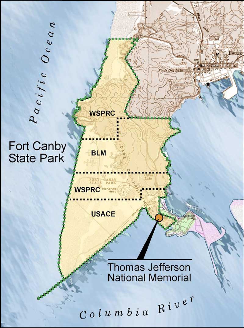
Figure 6.3 Fort Canby State Park Boundary and TJNM
location
(click on image for an enlargement in a new
window)
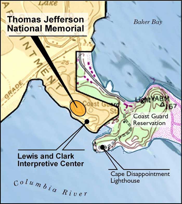
Figure 6.4 Detail map of TJNM location
(click on
image for an enlargement in a new window)
The developed portion of the memorial would be a fraction of the 10 acres and located to utilize existing visitor service facilities associated with the Lewis and Clark Interpretive Center. This alternative would also investigate the possibility of transferring all or a portion of the federal land ownership in the park determined excess by the BLM, USACE, and USCG to the NPS to aid in consolidated federal ownership and continuity of relationship with Fort Canby State Park.
Efforts would continue on the improvement of the state park in preparation for the Lewis and Clark Bicentennial, including the expansion of the Lewis and Clark Interpretive Center, new indoor and outdoor interpretive exhibits, and improved access to the interpretive center from the parking lot. The site design of the TJNM would commence after an assessment of the existing resources.
|
|
Site Management
Fort Canby State Park would continue to be managed by the WSPRC as a
major state park and destination for visitors to this area. The park
will likely go through some changes in operations and management in the
next few years in preparation for the Lewis and Clark Bicentennial, but
WSPRC would continue as the primary manager and operator of the park
with assistance from the NPS on interpretive programming. The TJNM would
be operated as a unit of Fort Clatsop National Memorial with cooperation
from the WSPRC on maintenance and staffing.
Resource Protection
Fort Canby State Park and the TJNM would maintain current levels of
resource protection since both the state park and the land associated
with the national memorial are already owned by public agencies. With
the possibility of ownership transferring to the NPS, land management
policy around the TJNM would become stricter, providing a higher level
of resource protection. As a result, both the state park lands and the
TJNM would have policies on resource protection which would limit any
threats to the resources at this site.
Visitor Experience
Fort Canby State Park already provides a high-quality visitor experience
because of its size and operation. Amenities available at this park
include camping, boat launch, day use areas, beach areas, lighthouses,
trails, the Lewis and Clark Interpretive Center, and other features.
Visitors have a multitude of experiences to select from at this
park.
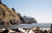
Thomas Jefferson, the country's third president, envisioned a nation from "sea to shining sea," and the TJNM would commemorate that vision. The memorial would be located near the LCIC overlooking the Pacific Ocean. The visitor would gain an understanding of the fulfillment of Jefferson's dream for the Nation through the relationship between this site and the Jefferson National Expansion Memorial in St. Louis, Missouri.
The location of the memorial would be selected to utilize the existing visitor service facilities associated with the Lewis and Clark Interpretive Center. One limitation to the experience of visiting the LCIC is the lack of adequate parking spaces and the location of parking in relation to the LCIC. The parking is 80 feet below the interpretive center and requires a strenuous walk to the building. WSPRC is seeking funding for an elevator or funicular system to provide better access to the LCIC and improve the visitor experience.
Cost Considerations
No costs for land acquisition are expected by the federal government
under this alternative since the state park and TJNM would remain under
the current state and federal ownership. A transfer of land ownership
from other federal agencies to the NPS would be considered under this
alternative, particularly for transfer of excess property owned by USACE
at the proposed TJNM site.
Design and construction costs associated with this alternative would be required for the development of the TJNM, which would likely consist of a memorial feature and viewing plaza of the Pacific Ocean along with pedestrian walkways from the LCIC at Fort Canby State Park. The development costs for the memorial including design, compliance, and construction are estimated to range from $500,000 to $1,500,000.
The operations and maintenance of the park unit would be managed as part of Fort Clatsop National Memorial, although it is expected that a cooperative agreement with WSPRC on the management of the site would provide some efficiencies. Permanent annual staffing for rangers and maintenance staff is estimated to cost $37,050 a year. There is an expectation of needs for additional temporary staffing during the bicentennial years of 2005 and 2006.
WSPRC is currently investing $3,000,000 in capital improvements associated with the Lewis and Clark Interpretive Center at Fort Canby State Park.
Feasibility
This alternative for Fort Canby State Park would be feasible since
little change of management is required. The creation of the TJNM
requires approvals at both the state and federal level but probably
would not require the same level of capital improvement costs associated
with the Station Camp site. Coordination with the NPS would be needed to
provide an integrated visitor experience for all of the sites in the
lower Columbia region including Fort Clatsop National Memorial. The
following contingencies would need to be addressed with this
alternative:
WSPRC approval of the creation of the Thomas Jefferson National Memorial within Fort Canby State Park,
Congressional approval of the creation and inclusion of the Thomas Jefferson National Memorial as part of Fort Clatsop National Memorial,
U.S. Congressional appropriation for the design and construction of the Thomas Jefferson National Memorial, and
WSPRC and NPS approval of a cooperative agreement for maintenance and operations of the Thomas Jefferson National Memorial.
Alternative D: Lewis and Clark National and State Historical Park
Under Alternative D, the Lewis and Clark National and State Historical Park would be created to develop a framework to present a comprehensive picture of the Expedition's experiences on the lower Columbia River. The national and state historical park designation would affect the broad multiple attributes of these sites within the context of Lewis and Clark history along the lower Columbia and Pacific Coast. The historical park would be accomplished within a cooperative framework which retains jurisdictional responsibilities of each partner.
General Description of Lewis and Clark National and State Historical Park
This alternative is based on the concept of an overarching federal and state cooperative approach in the form of the Lewis and Clark National and State Historical Park. The historical park would provide a framework for cooperation, collaboration, and coordination for interpretive programming, special programs, and events conducted at all of the Lewis and Clark sites in the region regardless of ownership. The federal and state sites associated with the Lewis and Clark story would be included within the historical park as listed below: (See Figure 6.5)
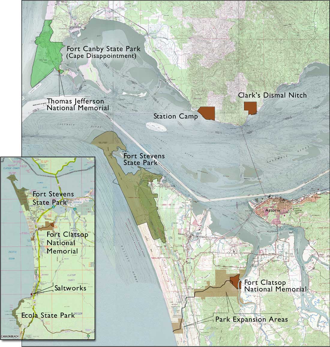
Figure 6.5 Regional map of parks and sites included in
the Lewis and Clark National and State Historical Park
(click on
image for an enlargement in a new window)
Lewis and Clark National Historic Trail
Lewis and Clark National Historical Park
National Park Service
Fort Clatsop National Memorial
Fort to Sea Trail
Sunset Beach Unit
Saltworks Unit
Clark's Dismal Nitch Unit
Station Camp Unit
Thomas Jefferson National Memorial
Lewis and Clark State Historical Park
State of Washington
Fort Canby State Park
State of Oregon
Ecola State Park
Fort Stevens State Park
This alternative also includes consideration of two Oregon park sites which would provide important additional interpretive opportunities and a more comprehensive picture of the expedition's experiences in the lower Columbia region.
If plans are implemented for tribal and/or Lewis and Clark history interpretation at other sites, (for example Chinook Park, Fort Columbia State Park, etc.), programs at these sites could also be included in the overall historical park coordination efforts.
The creation of the Lewis and Clark National and State Historical Park would include a framework to present a comprehensive picture of the Expedition's journey. The historical park will not only encompass the three sites being studied, but also other Lewis and Clark sites on the lower Columbia and Pacific Coast. This alternative will provide a coordinated experience for the public and will preserve a piece of American history that otherwise might be irreparably impacted or even forgotten.
Within this alternative, visitors will have the opportunity to develop a of sense of connection between Clark's Dismal Nitch, Station Camp, Cape Disappointment, and the other significant Lewis and Clark sites in the region. This connection will bring more continuity to the Lewis and Clark story and establish the significance of this part of the journey in our country's history.
The costs associated with the historical park would be primarily administrative since the underlying ownership and management of the individual sites will remain intact.
In order to promote good public understanding of the various Lewis and Clark sites, development costs associated with the historical park would include signing at all associated Lewis and Clark sites in the lower Columbia region. The development costs under this element of the alternative would be expected to range from $300,000 to $500,000.
The staffing and operations costs would be primarily administrative and would include one additional employee plus additional space, equipment, and supplies. The annual operating costs would be expected to total approximately $53,000.
This alternative is subject to the following contingencies:
Congressional authorization to establish the Lewis and Clark National and State Historical Park framework,
Congressional appropriation for operation of the Lewis and Clark National Historical Park, and
WSPRC approval of participation in the Lewis and Clark National and State Historical Park, and
Oregon Parks and Recreation Department approval of participation in the Lewis and Clark National and State Historical Park.
Megler Safety Rest
Area
(Clark's Dismal Nitch — Unit of Lewis and Clark National
Historical Park)
General Description of the Management Alternative
In this alternative, Megler Safety Rest Area would be transferred to NPS
ownership and management as part of the Lewis and Clark National
Historical Park with an investigation of potentially eliminating potable
water service at the site and finding another solution for restroom
service. As a result, the WSDOT safety rest area may be moved to an
undetermined location or eliminated. Relocation of the safety rest area
is dependent on availability of WSDOT capital construction funding.
The NPS would seek authorization based on study results to establish a boundary encompassing the safety rest area property, Clark's Dismal Nitch, a portion of the Megler Creek watershed and the escarpment along the north side of the existing safety rest area property. The NPS would seek ownership of the property adjacent to the safety rest area, which encompasses the Dismal Nitch, and would seek to obtain a conservation easement encompassing the forested uplands surrounding the Dismal Nitch and the wooded escarpment to preserve the integrity of the scenic viewshed surrounding the historic Dismal Nitch site (See Figure 6.6).
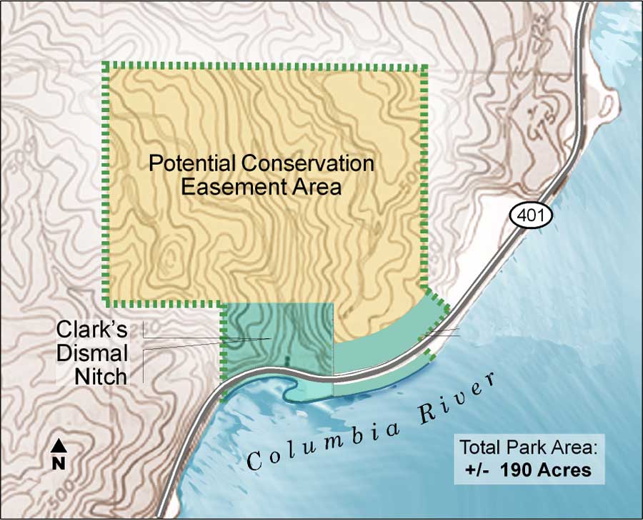
Figure 6.6 Boundary of Clark's Dismal Nitch Unit of the
Lewis and Clark National Historical Park
(click on image for an
enlargement in a new window)
Site Management
In this alternative, the current safety rest area site itself and the property
in the area of the historic Dismal Nitch would be combined with a
conservation easement over the surrounding private property to create Clark's Dismal
Nitch. This site would be managed by the NPS through the newly created Lewis
and Clark National Historical Park.
The NPS would acquire the property northwest of the current rest area as a land base for the protection and interpretation of the Dismal Nitch story, along with a conservation easement of the surrounding cultural landscape. Service to visitors would change with the removal of the safety rest area use on the site, although that function may continue to be provided at a new location a few miles away.
Resource Protection
The site of the existing safety rest area would be rehabilitated and
improved for the purposes of interpretation. As a land management
agency, the NPS emphasizes the protection of natural and cultural
resources. As a result, the resource protection at this site would be
strengthened significantly.
The NPS would also acquire additional property northwest of the existing safety rest area at the historic site of this important Lewis and Clark story to protect the natural and cultural resources associated with the site. This property would then be provided many of the standard protections associated with federal public lands, including the National Environmental Policy Act, Section 7 of the Endangered Species Act, and the National Historic Preservation Act.
In addition, the NPS would consider obtaining a conservation easement over the land surrounding the historic Dismal Nitch to protect the historic, natural, and scenic qualities of the property. The property acquisition along with the conservation easement would become the Clark's Dismal Nitch Unit of the Lewis and Clark National Historical Park. Preserving this landscape setting from potential timber harvest can be achieved through a conservation easement over the surrounding private property. In addition to protecting the forested hillside as a visual amenity, a conservation easement would protect slope stability, water quality of the stream and its watershed, and habitat for flora and fauna.
Visitor Experience
Under this alternative, the Megler Safety Rest Area no longer would be
operated as a safety rest area, but instead would be rehabilitated to
emphasize interpretation of the story at the Dismal Nitch. To enhance
the visitor experience, opportunities to walk to the area believed to be
the site of the Dismal Nitch would be provided, along with
interpretation relating to the Corps of Discovery's story. Consideration
of safe pedestrian access alternatives to the Dismal Nitch would be an
essential part of the site design to address the potential for
pedestrians crossing State Route 401. In addition, the potential exists
for reduction in the paved surface of the existing rest area site
through redesign. Night sky viewing opportunities would potentially be
enhanced contingent on lighting changes.
The interpretive improvements would include interpretive panels, orientation panels, interpretive trails, and places for group interpretive talks which tie thematically with interpretation provided at other Lewis and Clark sites managed by the NPS and the state. Other site improvements would include culvert replacement and stream restoration of Megler Creek and provision of a smaller comfort station, but not to the scale of the existing rest area facilities.
The visitor experience would also be enhanced with the provision of guided interpretive tours by NPS rangers and interpreters at peak visitation periods. The improvement of the visitor experience would be guaranteed to last in perpetuity with the protection of the cultural landscape as it exists surrounding the site.
Cost Considerations
Costs for land acquisition are expected to be captured through a land
exchange or donation by a land conservancy group. The costs for land
acquisition to bring the property into the public domain are expected to
range from $500,000 to $1,300,000 for acquiring the Dismal Nitch site
and a conservation easement over the surrounding land along with a land
exchange of donation from the State of Washington for the WSDOT
property. The development costs for the site include a rehabilitation of
the existing safety rest area and the development of trails and
interpretive exhibits and other previously described improvements. The
development costs are estimated to be in the range of $1,250,000 to
$2,000,000.
The operations and maintenance of the park unit would be managed by the NPS through the Lewis and Clark National Historical Park administrative offices. Annual staffing for seasonal rangers and maintenance staff is estimated to cost $8,150 a year.
Potential cooperative agreements with WSPRC for maintenance of the site would be explored since Fort Columbia State Park is only four miles from the site.
Feasibility
This alternative for Clark's Dismal Nitch would be feasible, but is
subject to the following contingencies:
Congressional authorization of the addition of Clark's Dismal Nitch to the Lewis and Clark National Historical Park,
Congressional authorization and appropriation to obtain a conservation easement or use agreement on the private lands surrounding Clark's Dismal Nitch,
Congressional appropriation for the design and construction of improvements to Clark's Dismal Nitch, and
WSDOT approval of the relocation or closing of the Megler Safety Rest Area.
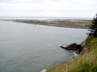
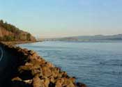 Tongue Point |
 Saddle Mountain |
 Cape Disappointment |
Station Camp
(Unit of Lewis and Clark National Historical Park)
General Description of the Management Alternative
The Station Camp site would be developed through the realignment of the
highway to create a riverfront park commemorating the Corps of
Discovery's experiences at the site. The park would incorporate
improvements such as parking, safe ingress/egress, a comfort station,
pedestrian walkways, direct access to the Columbia River, enhanced
interpretation of the history of the site, and viewpoints so visitors
can enjoy the surrounding landscape (See Appendix C).
The park would be owned and managed by the NPS as part of the Lewis and Clark National Historical Park. In addition, the NPS would consider obtaining a conservation easement over the remainder of the private land to protect the scenic, historic, and natural qualities of the site.
|
|
Site Management
Station Camp would be owned and managed by the NPS as part of the Lewis
and Clark National Historical Park. The improved park site would be
located between the realigned highway and the Columbia River. The site
would provide improved visitor access, a comfort station, enhanced
interpretation of the Lewis and Clark story at Station Camp, and
viewpoints of the surrounding landscape.
The privately owned land surrounding the site on the west, north, and east would continue to be managed by the current owners although with the addition of an agreement to preserve the natural and scenic qualities of the backdrop of Station Camp. St. Mary's Church would continue to be privately owned and managed by the Catholic Archdiocese of Seattle. The church and the NPS would establish a joint use agreement for the parking, comfort station, and public gathering spaces.
Resource Protection
This alternative for Station Camp would provide much greater resource
protection than currently exists. Approximately nine acres of property
would be transferred to the NPS by the WSPRC for the purpose of
developing a riverfront park commemorating the history of the Expedition
at the site. This property would then provide many of the standard
protections associated with federal public lands including NEPA, Section
7 of the ESA, and the NHPA. In addition, the NPS would consider
obtaining a conservation easement over a portion of the remaining
private property surrounding the park site to protect the historic,
natural, and scenic qualities of the property as a backdrop to the
park.
Visitor Experience
Under this alternative, the visitor experience at Station Camp would be
greatly improved from the experience at the existing state park wayside.
The development of the riverfront park would enhance the visitor
experience at the site by providing parking, safe egress/ingress, a
comfort station, direct access to the Columbia River, enhanced
interpretation of the Lewis and Clark story, group gathering areas, and
viewpoints so visitors can enjoy the surrounding landscape.
NPS rangers would be able to use areas on site for interpretive programs. The site would be designed for maximum accessibility to accommodate a variety of users including children, school groups, adults, senior citizens, and the disabled. It is expected the site would also accommodate anglers, who have historically fished from the banks of the Columbia River at this site.
The primary interpretive themes proposed for this site include the following:
Jefferson's Vision
"Full View of the Ocean," by the Corps of Discovery (Mission Accomplished)
Clark's survey of Columbia Estuary
Station Camp vote on the location of winter camp
Expedition relations with the Chinook Tribe and other native people
Secondary themes include:
McGowan family history, including the canneries
St. Mary's Church history
Natural ecology of the area
Cost Considerations
Land acquisition for the Station Camp site would be achieved via
donation of the nine-acre park site to the NPS from the state of
Washington.
In addition, the acquisition of a conservation easement on private lands surrounding the publicly owned land to protect the scenic backdrop may cost up to approximately $1,000,000 depending on the extent of the easement boundary. The park improvement costs including design, compliance, and construction are estimated at $2,500,000 to $3,000,000 and would be part of the donation. These improvements include vehicular access, parking, a comfort station, native landscaping, pedestrian walkways, interpretive exhibits, and viewpoints of the surrounding landscape.
No additional development costs are expected under this alternative except for nominal NPS signing. The operations and maintenance of the park unit would be managed out of the Lewis and Clark National Historical Park administrative offices. Permanent annual staffing for rangers and maintenance staff is estimated at $14,860.
There would be an expectation of needs for additional special event costs during the bicentennial years of 2005 and 2006 which are estimated to be $30,000. Potential cooperative agreements with WSPRC for maintenance of the site would be explored since Fort Columbia State Park is less than one mile from the site.
Feasibility
This management alternative would be feasible although the proposed
improvements at Station Camp rely on a successful "willing seller"
negotiation to acquire the additional property necessary for the
realignment of the highway and development of the park. The alternative
would be contingent on the following:
WSPRC approval of a transfer of an expanded Station Camp State Park to the NPS,
U.S. Congressional authorization of the addition of Station Camp to the Lewis and Clark National Historical Park,
U.S. Congressional authorization and appropriation of the acquisition of a conservation easement to the north of the Station Camp site, and
WSPRC and NPS approval of a cooperative agreement to maintain the Station Camp park site through NPS funding.
The funding for acquisition, design, and construction of the highway realignment and park development has already been appropriated at the state level. It is anticipated the NPS and WSPRC would develop a cooperative agreement regarding the maintenance of the park site since Fort Columbia State Park is less than one mile away from Station Camp.
Fort Canby State Park
(Thomas Jefferson National Memorial)
General Description of the Management Alternative
The greater portion of Fort Canby State Park would continue to be
managed by the WSPRC, with the additional creation of the TJNM within
the boundaries of the park. The memorial would be approximately 10 acres
in size and owned and managed by the NPS as a unit of the Lewis and
Clark National Historical Park.
The developed portion of the memorial would be a fraction of the 10 acres and located to utilize existing visitor service facilities associated with the LCIC.
This alternative would also investigate the possibility of transferring all or a portion of the federal land ownership in the park from the BLM, USACE, and USCG to the NPS.
Efforts would continue on the improvements of the park in preparation for the Lewis and Clark Bicentennial including an expansion of the Lewis and Clark Interpretive Center, new indoor and outdoor interpretive exhibits, and improved access from the parking lot to the interpretive center.
|
|
Site Management
Fort Canby State Park would continue to be managed by the WSPRC as a
major state park destination for visitors to this area. The park will
likely go through some changes in operations and management in the next
few years in preparation for the Lewis and Clark Bicentennial, but WSPRC
would continue as the primary manager and operator of the park with
assistance from the NPS on interpretive programming. The TJNM would be
operated as a unit of the Lewis and Clark National Historical Park with
cooperation from the WSPRC on maintenance and staffing.
Resource Protection
Fort Canby State Park and the TJNM would maintain current levels of
resource protection since both the state park and the national memorial
are already owned by public agencies. With the possibility of ownership
transferring to the NPS, land management policy around the TJNM would
become stricter, providing a higher level of resource protection. As a
result, both the state park lands and the TJNM would have strict
policies on resource protection, limiting any threats to the resources
at this site.
Visitor Experience
Fort Canby State Park already provides a high-quality visitor experience
because of its size and operation. Amenities available at the park
include camping, boat launch, day use areas, beach areas, lighthouses,
trails, the Lewis and Clark Interpretive Center, and other features.
Visitors have a multitude of experiences to select from at this
park.
|
|

Thomas Jefferson, the country's third president, envisioned a Nation from "sea to shining sea," and the TJNM would commemorate that vision. The memorial would be located near the LCIC overlooking the Pacific Ocean. The experience for the visitor would be in learning about the fulfillment of Jefferson's dream and understanding the relationship between the Jefferson National Expansion Memorial in St. Louis, Missouri and the Thomas Jefferson National Memorial at Fort Canby State Park.
The location of the memorial would be selected to utilize existing visitor service facilities associated with the LCIC. One limitation to the experience of visiting the LCIC is the number of parking spaces and the location of parking in relation to the LCIC. The parking is 80 feet below the interpretive center and requires a strenuous walk to the building. WSPRC is seeking funding for an elevator or a funicular system to provide better access to the LCIC and improve the visitor experience.
Cost Consideration
No costs for land acquisition are expected by the federal government
under this alternative since the state park and national memorial would
remain under the current state and federal ownership. A transfer of land
ownership from other federal agencies to the NPS would be considered
under this alternative.
Development costs associated with this alternative would be required for the development of the TJNM, which would likely include a memorial feature and viewing plaza of the Pacific Ocean, along with pedestrian access from the existing LCIC at Fort Canby State Park. The development costs for the memorial, including design, permitting, and construction are estimated to range from $500,000 to $1,500,000.
The operations and maintenance of the park unit would be managed out of the Lewis and Clark National Historical Park administrative offices, but it is expected that a cooperative agreement with WSPRC on the management of the site would provide some efficiencies. Permanent annual staffing for rangers and maintenance staff is estimated to cost $37,050 a year.
WSPRC is currently investing over $3,000,000 in capital improvements associated with the Lewis and Clark Interpretive Center at Fort Canby State Park.
Feasibility
This alternative for Fort Canby State Park would be feasible since
little change of management would be required. The creation of the TJNM
would require approvals at both the state and federal level, but would
not require the same level of capital improvement costs as the Station
Camp site. This alternative provides a high degree of coordination among
agencies to provide an integrated visitor experience for all of the
sites in the lower Columbia region including Fort Clatsop. The following
contingencies would need to be addressed with this alternative:
WSPRC approval of the creation of the Thomas Jefferson National Memorial within Fort Canby State Park,
Congressional appropriation for the design and construction of the Thomas Jefferson National Memorial, and
WSPRC and NPS approval of a cooperative agreement for maintenance and operations of the Thomas Jefferson National Memorial and securing funds needed to implement the agreement.
Other Sites Under the Historical Park Designation
|
|

Fort Stevens State Park
In this alternative, Fort Stevens State Park would remain under the
management of the Oregon Parks and Recreation Department (OPRD) but
would become part of the Lewis and Clark National and State Historical
Park. Currently the northern portion of the park is owned by the U.S.
Army Corps of Engineers, and is operated by OPRD under lease agreement
with USACE. The remainder of the park is owned by the state of Oregon.
This ownership would continue, unless USACE would transfer most of its
lands to OPRD. OPRD and USACE would negotiate the conditions of such a
transfer. The NPS will not seek ownership of any portion of Fort
Stevens, but would cooperate with OPRD in managing the Lewis and Clark
related interpretive story, including the Clatsop village site.
The current master plan for Fort Stevens and preliminary site plan for the old fort and Clatsop village sites of the park identify a set-aside area for protecting some of the riverfront area for study and interpretation of the Clatsop occupation. NPS would work collaboratively with OPRD on completing a Parkwide Interpretive Plan for the park that would define the approach for interpreting and providing access to the Clatsop village area. The Interpretive Plan would also address other areas of the park that represent the landscape of the area at the time of Indian occupation and early fort settlement. OPRD would also address other, non-Lewis and Clark interpretive themes in the Parkwide Interpretive Plan, such as the history of the jetty, Fort Stevens, and shipwrecks.
The Clatsop village site is shown on historic maps as being near the north shore of Point Adams, which was the original mouth of the Columbia River prior to the construction of the south jetty. This was a strategic location for contacting Native Americans and later, European-American traders traveling on the Columbia River. Point Adams is still discernible today, although sand accretion to the west due to the jetty has drastically changed the configuration of the mouth of the river.
The village site has a view of the Columbia River to the north. The Civil War earthworks lies to the south of the village site. Beyond the earthworks, to the south, are the remains of Fort Stevens which was constructed at a later date. Site management for the interpretation of the Clatsop village would need to address protecting the integrity of later historic elements of the jetty construction and Fort Stevens. Some site restoration and potential village marking, or limited reconstruction, would be considered for the Clatsop village site.
In-depth archaeological surveys would be completed to better determine the specific location of the village. OPRD would request NPS support through staffing, technical assistance, and funding participation for the completion of the archeological investigation.
The visitor experience would be enhanced by the use of a spatial buffer between the village site and the fort site structures. The interpretive improvements would include interpretive panels, orientation panels/signs, interpretive trails and viewpoints, and places for group talks which tie thematically with interpretation provided at other Lewis and Clark sites managed by the NPS and the state of Washington. Interpretive staff from OPRD and NPS would provide guided interpretive tours of the village and Point Adams site.
|
"I determine to Set out early tomorrow with two canoes & 12 men in quest of the whale, or at all events to purchase from the Indians a parcel of the blubber, for this purpose I made up a Small assortment of merchandize, and directed the men to hold themselves in readiness &c." William Clark, January 5th, 1806 |
OPRD is planning a renovation of the visitor center and museum at the fort site. Space in this facility would be devoted to the story of the Clatsop occupation of the area and their interaction with the members of the Lewis and Clark Expedition, and others such as the Hudson's Bay Company. In the future, OPRD would request that the NPS assist with developing interpretive themes, designing exhibits, and constructing interpretive improvements for the visitor center and outdoor interpretive areas.
Ecola State Park
In this alternative, OPRD would continue to own and manage Ecola State
Park. The park would also be included in the new Lewis and Clark
National and State Historical Park. Ecola State Park includes the
headland that William Clark and a party from the Corps of Discovery
crossed on January 6, 1806 in search of a beached whale they had learned
of from the Clatsop Indians. Clark's party found the whale after
descending to "a butifull sand shore" and crossing a creek, which
Clark later named Ecola Creek, using the Chinook work for whale
("ekoli").
OPRD has been working with the Oregon Forest Resource Institute to complete trail improvements and the installation of interpretive signs that tell the story of Native American use of the headland trail and of Clark's visit. These improvements will be in place by the summer of 2004.
OPRD would work with the NPS to further refine the interpretive opportunities offered at Ecola State Park. This park has two trailhead parking lots with access to the beaches and views of the rocky coast. Visitors can look to the south toward the beach that Clark visited from viewpoints along park trails. The park does not have a visitor center, and no real potential to provide for such a structure is available due to steep, slide prone slopes. However, the park landscape is preserved in a state similar to when Clark and his party visited the area.
As part of a cooperative agreement with OPRD, the NPS would provide technical assistance such as contribution of seasonal interpretive staff and support for special programs and events.
Other Alternatives Considered but Rejected
Fort Canby State Park
(Unit of
Fort Clatsop National Memorial)
With Fort Canby State Park providing the second highest revenue for the Washington State Park system, an alternative that would involve the transfer of management to the NPS was rejected because of cost considerations, such as the potential loss of revenue to the state, and the substantial costs associated with transferring administrative and management functions to an entirely new agency. There were also concerns related to the loss of efficiency and effectiveness Washington State Parks would experience by removing Fort Canby from the regional management system, which currently is responsible for several other parks and state lands in the surrounding area.
In addition, Fort Canby State Park provides opportunities for all types of users and is used in ways which do not specifically meet the objectives associated with Fort Clatsop National Memorial. The Fort Clatsop National Memorial was established to protect and interpret the Lewis and Clark story in the lower Columbia region, whereas Fort Canby State Park serves a much broader function related to several historical and interpretive themes and outdoor recreation and camping.
It was determined that the opportunities associated with establishing an NPS presence at Fort Canby State Park could be adequately studied within the other range of alternatives proposed.
| <<< Previous | > Contents < | Next >>> |
focl/draft_boundary_study/sec6.htm
18-Jul-2003