|
NATIONAL PARK SERVICE
Atlantic and Gulf Coasts Recreation Area Survey |

|
UNDEVELOPED SEASHORE AREAS IN MARYLAND AND VIRGINIA

|
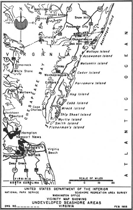
| Undeveloped Seashore Areas of Maryland and Virginia (Vicinity Map) (click on image for an enlargement in a new window) |
Assateague Island
Maryland
| Location: | Off the mainland, south of Ocean City to Virginia State line. |
| Accessibility: | By boat only. |
| Description of Area: | A 20-mile strand of excellent beach with medium low dunes bound and restricted by beach grasses of varying density. Toward the bay the dunes fall away into heavily grass-covered marshes where, on the firmer and higher ground, patches of woodland rise. There are intermittent stretches of flat barren sands across the entire width of the island where blowouts have occurred. |
| Present Use: | The area is the site of one of the largest seashore developments along the Atlantic coast. A hard-surfaced road has been constructed the length of the island and lateral streets have been graded and marked out. Several cottages have been constructed and several thousand lots have been sold. |
| Analysis: | The advanced stages of real estate development appear to preclude the possibility of this area being set aside for public recreational use. |
Assateague Island
Virginia
| Location: | Off mainland, from Maryland State line southeast to Chincoteague, Virginia. |
| Accessibility: | By boat only. |
| Description of Area: | A continuation of Assateague Island, Maryland, with about 12 miles of excellent beach and a luxuriant growth of vegetation in a relatively unspoiled state. The beaches are wide and clean, the foreshore gently sloping. This portion of the island is wider, has higher dunes and is less subject to blowouts; it is an excellent example of typical Atlantic seacoast. |
| Present Use: | The southern third of the island, lying between Chincoteague and the sea, is a national wildlife refuge. The island is undeveloped. |
| Analysis: | Compatible use of this area might be considered so that the excellent quality of its recreational resources could be utilized to the greatest advantage. |
Parramore Island
Virginia
| Location: | 5 miles off Wachapreague, Virginia. |
| Accessibility: | By boat only. |
| Description of Area: | It is the longest in the chain of coastal islands lying off the Virginia Eastern Shore. The island is undeveloped and relatively unspoiled, and its beach offers excellent opportunities for bathing, surf casting and other forms of seashore recreation. Within the forested area on the island are several fresh-water ponds and marshes which attract migratory waterfowl; along the west side of the island is an interesting salt marsh zone. The island is 7-1/2 miles long, averages three-fourths of a mile in width and contains approximately 6,255 acres of land. |
| Present Use: | Privately owned and used by Mrs. Jean Maxwell Saunders and Dr. Carl J. Schmidlapp. It is understood, however, that the Navy has recently requested funds to obtain the island for a target range. |
| Analysis: | It is one of the best remaining undeveloped areas along this section of the Atlantic coast, with important scenic and wildlife values, and would make an excellent public seashore recreation area. |

|
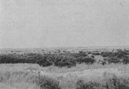
| Ocean Beach |

|
| Gull Rookery, Parramore Island |
Hog Island
Virginia
| Location: | 5 miles off the Eastern Shore of Virginia, just south of Parramore Island. |
| Accessibility: | By boat only. |
| Description of Area: | This island is almost a barren strip of sand, 6 miles long by less than 1 mile wide. Since 1900, the entire village of Broad Water--a town of several hundred people with a church, school and post office--has been washed into the sea. The lower half of the beach is filled with stumps of trees and bordered with piles of dead tree trunks and bushes. Vegetation is sparse; there are some scrub trees and bushes well back from the beach. |
| Present Use: | The island has no residents. There is limited grazing, and the island is visited occasionally by fishing parties. |
| Analysis: | The considerable washing away of sections of the island and its isolated position are obstacles to its consideration as a public seashore recreation area. If the dunes and shoreline were stabilized, it would make an attractive area. |
 
|
| Hog Island |
Virginia
Cobb Island
Directly south of Hog Island and about 8 miles from the mainland lies Cobb Island. It is less than 6 miles in length and almost devoid of vegetation. The beach is wide and fairly clean but the foreshore dips rather sharply into the sea. It is understood that this island also once supported a community which has been washed away by the sea. The processes of erosion and its isolation deter its consideration as a public seashore recreation area.

|
| Cobb Island |
Wreck Island
An island off the Eastern Shore of Virginia directly east of Cape Charles and south of Cobb Island, which supports only a marshy type of vegetation. The dunes are low and unstable, with indications that this island has been washed over many times. There is no high, firm ground on the island. Its low elevation, isolation, and erosion difficulties make it undesirable for consideration as a public seashore recreation area.
Ship Shoal Island
This island lies directly south of Wreck Island. It is similar in character and does not warrant consideration as a public recreation area.
Wallops Island
An island off the Eastern Shore of Virginia, south of Chincoteague and east of Mappsville, which possesses some sizable portions of forested land, narrow beaches, a few dunes, and evidences of erosion. It contains an antiaircraft military installation which is the only development of the island. The area is not as desirable for seashore recreation purposes as some of its neighbors, such as Assateague or Parramore Islands.
Assawoman Island
Just to the south of Wallops Island lies Assawoman, similar in character but with less cover. This is a target area under military jurisdiction. The island is undeveloped.
Metomkin Island
A slender, finger-like island, south of Assawoman Island and east of Accomac, possessing very little vegetative cover, narrow littered beaches, and unstable dunes. The island is undeveloped. The island does not possess the resources desirable for a public seashore recreation area.
Cedar Island
An island lying northeast of Wachapreague and southeast of Accomac which contains some good tree and shrub cover, and is wider than the island immediately to the north. The beaches are broader and less littered. The island has been subdivided and lots are being sold in anticipation of the construction of a causeway or bridge from the mainland. The island is not as desirable for seashore recreation purposes as Parramore Island, directly to the south, and would, no doubt, be excessive in cost.
Myrtle Island
One of the chain of small washed-over islands lying off the Eastern Shore of Virginia east and south of Cape Charles; it is barren of vegetation. It is not considered desirable as a potential seashore recreation area.
Smith Island
Near the southern tip of the Eastern Shore of Virginia lies Smith Island. This area, like the others in the immediate vicinity, lacks the necessary natural resources to qualify it as a potential public seashore recreation area.
Fisherman's Island
The smallest of the islands lying off the Eastern Shore of Virginia is directly south of Cape Charles. It is similar in character to Smith Island and is not considered desirable as a potential public seashore recreation area.
| <<< Previous | <<< Contents>>> | Next >>> |
rec_area_survey/ag/md-vi.htm
Last Updated: 25-Jun-2007