|
NATIONAL PARK SERVICE
Pacific Coast Recreation Area Survey |

|

UNDEVELOPED SEASHORE AREAS IN OREGON (Northern Portion)

|
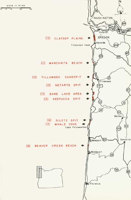
| Oregon — Northern Portion (Vicinity Map) (click on image for an enlargement in a new window) |
10
Clatsop Plains Area
Northern Oregon
LOCATION: Five miles southwest of Astoria.
ACCESSIBILITY: By automobile over hard surfaced spur roads from U. S. Highway 101.
DESCRIPTION OF AREA: This area comprises 4-1/2 miles of ocean frontage and extends inland an average of 1/2 mile. The shoreline is an attractive sandy beach averaging 50-75 yards in width above the high tide line. A very gently sloping foreshore makes this beach extremely wide at low tide. Some sea debris has been deposited above the high tide line, but the amount is relatively minor for this section of the Pacific Coast. A partially stabilized swath of small dunes and sand some 150-200 yards wide is immediately inland and parallel to the beach. Upland and adjacent to the sand area the terrain becomes rolling, with hills 25-50 feet high intermingled with long, narrow lakes and marshes. Large portions of this hilly section are covered with a dense growth of young pine.
PRESENT USE: Approximately half of the area is being developed for subdivisions. The remainder is undeveloped.
ANALYSIS: The area possesses a potentially valuable recreation beach and would render great service if acquired for that purpose. The inland lakes are of recreation value for fresh-water bathing and water sports. Immediately to the north is Camp Clatsop, with similar seashore values. If retained in public ownership that area could serve as a possible addition to Clatsop Plains when the need warrants it.

|
| Clatsop Plains Area |
11
Manzanita Beach
Northern Oregon
LOCATION: Twenty-two miles south of Seaside and 28 miles north of Tillamook.
ACCESSIBILITY: By hard surfaced road from U. S. Highway 101.
DESCRIPTION OF AREA: A scenic, one-mile section of wide beach, stabilized sand dunes and woodland. The attractive beach is approximately 25 yards wide at high tide and approximately 100 yards wide at low tide. This wide, light tan, fine-grained sandy beach, with its gently sloping foreshore, is suitable for a variety of recreation activities. Inland, the area forms a transition from the beach to sand dunes to finally a dense stand of lodgepole pine.
PRESENT USE: Except for a few private residences, the area is undeveloped, although it receives heavy public recreation use.
ANALYSIS: This area will be completely developed for residential purposes in a relatively short period of time. Quick action will be required to save sufficient acreage for recreation or an addition to Nehalem Bay State Park which adjoins it on the south. Although feasibility of acquiring the area is questionable, it should be given every consideration for public seashore recreation purposes.

|
| Manzanita Beach |
12
Tillamook Sandspit
Northern Oregon
LOCATION: Eight miles northwest of Tillamook.
ACCESSIBILITY: Via ten miles of hard surfaced road from Highway 101 and Tillamook.
DESCRIPTION OF AREA: This is a partially wooded sandspit with an ocean frontage of approximately 2-1/2 miles, and with 3 miles of frontage of Tillamook Bay. The spit is about one-half mile wide at its broadest portion. There is is a wide sandy beach at the northern end of the spit, but along the other sections of the ocean front the beach has been badly eroded by wave action. The northern half of the spit is mainly a grass-covered sandflat, while the southern half in general is gently rolling and covered with trees and shrubs. A portion has been leveled and planted with beach grass for erosion control. A few scattered sand dunes are found along the northern fringe of the wooded section. The bay side of the sandspit is an important wintering area for the various geese, including the black brant, and provides feeding and resting habitat for a variety of migrating waterfowl, as well as marine and shore birds. The Corps of Engineers maintains a seawall at the southern end of the spit.
PRESENT USE: The area is completely undeveloped and receives no significant use. It is almost entirely in federal and county ownership at present.
ANALYSIS: This sandspit possesses excellent biological and potential public recreation values. Land values will increase and private development will commence with the construction of a road on the seawall by the Corps of Engineers. Immediate action will be necessary if this fine area is to be utilized for public recreation purposes and conservation of its inherent natural values.

|
| Tillamook Sandspit |
13
Netarts Spit
Northern Oregon
LOCATION: Six and one-half miles southwest of Tillamook.
ACCESSIBILITY: By ten miles of hard surfaced road from Tillamook through Cape Lookout State Park. There are no existing roads on the sandspit.
DESCRIPTION OF AREA: This area is a sandspit about 3-1/2 miles long, varying in width from 1/2 mile to a few hundred yards. It contains approximately 500 acres. The majority of the spit is sand dunes ranging from 10 to 15 feet high, which are partially stabilized with beach grass and other ground covers. A large portion supports a dense growth of shore (lodgepole) pine. The wide, clean, attractive sandy beach extends the entire length of the area. The bay side of the spit provides migrating, feeding and resting habitat for a variety of waterfowl, marine and shorebirds.
PRESENT USE: The entire sandspit is undeveloped. Portions of it are under a joint dune stabilization program by the State and private owners.
ANALYSIS: This undeveloped seashore area possesses excellent recreation potentialities. Also, the bay side of the spit offers good opportunity to preserve some very important biological values. It is understood that the State of Oregon is interested in acquiring the area as a possible addition to the adjacent Cape Lookout State Park.

|
| Netarts Spit |
14
Sand Lake Area
Northern Oregon
LOCATION: Four and one-half miles south of Cape Lookout and 13 miles southwest of Tillamook. It is immediately north of Tierra Del Mar.
ACCESSIBILITY: By hard surfaced road from coastal highway U. S. 101.
DESCRIPTION OF AREA: The area comprises one and one-half miles of ocean frontage, the majority of which is a sandy beach. At low tide, the beach is approximately 100 yards wide, due to the very gentle slope of the foreshore. Near the high tide line, logs and other debris have been deposited by the sea as is typical along the northern Pacific Coast. Two sandspits which form Sand Lake are mainly sandflats and dunes, with considerable portions stabilized with beachgrass or woodlands of shore (lodgepole) pine. Along the east shore of Sand Lake is a grass and tree-covered island, formed by a change in the drainage or outlet to Sand Creek. The majority of Sand Lake is relatively shallow, with a considerable portion in marshland. Low tides expose extensive mudflats.
PRESENT USE: The majority of the area is used for a ranch type of agriculture. Also, there is a small county park on the island.
ANALYSIS: This is an area with many fine qualities, including excellent recreation potentialities and interesting biological values. It is important that Sand Lake be considered for public recreation purposes to help meet the need for areas of this type.

|
| Sand Lake Area |
15
Nestucca Spit
Northern Oregon
LOCATION: Adjacent to Pacific City, 27 miles south of Tillamook.
ACCESSIBILITY: By four miles of hard surfaced roads from U. S. Highway 101.
DESCRIPTION OF AREA: This area includes the Nestucca Sandspit and Cape Kiwanda, involving approximately five miles of ocean shoreline. Cape Kiwanda is a 200-foot high scenic vista point. The adjoining property, which is also adjacent to the boundary of the Siuslaw National Forest, is mainly large, scenic, migrating sand dunes interspersed with thick growths of spruce, pine and lesser vegetative cover. Three-fourths mile offshore is Haystack Rock, 327 feet high. Immediately south of Cape Kiwanda is the Nestucca Sandspit, with its very wide and attractive sandy beaches. Sand flats predominate on the spit, and lesser portions include partially stabilized sand dunes from 10 to 15 feet in height.
PRESENT USE: Immediately west of Pacific City across the Nestucca River is a small settlement which includes private residences and resort developments near the beach. Within the area itself is a small county park, two parcels of public domain and two parcels of national forest land.
ANALYSIS: This relatively undeveloped area possesses excellent scenic and recreation qualities. It should be given every consideration for a possible seashore reserve to meet the recreation needs for the future.

|
| Nestucca Spit |
16
Siletz Spit
Northern Oregon
LOCATION: Immediately north of Gleneden Beach.
ACCESSIBILITY: By Highway 101 and surfaced road through Gleneden Beach. There are no roads on the sandspit.
DESCRIPTION OF AREA: This area consists of three miles of ocean frontage. It includes the Siletz Sandspit, and extends south to Gleneden Beach. Along this ocean shoreline is a coarse sandy beach which has a width of 150-200 feet at high tide. The foreshore has a fairly steep slope, and undertow is likely. Much of the sandspit is comprised of drifting or stabilized sand, with a few large dunes; leeward of these dunes are thick growths of pine. Immediately north of Gleneden Beach the terrain is more undulating with intermittent flat areas elevated 100-125 feet above the ocean level. South of the spit are dense woodlands of cedar, hemlock and pine. Along the ocean are evidences of severe gully erosion. Within Siletz Bay, and adjacent to the area, is an extensive marshland where waterfowl and shorebirds are seasonally abundant.
PRESENT USE: Most of the area is used for ranching purposes. There are a few scattered private residences near Gleneden Beach.
ANALYSIS: This area possesses many fine seashore values. It should certainly be considered for public recreation purposes, despite the fact that there are other similar sandspits in Oregon with superior qualities.

|
| Siletz Spit |
17
Whale Cove
Northern Oregon
LOCATION: Immediately south of Depoe Bay and 15 miles north of Newport.
ACCESSIBILITY: Directly off U. S. Highway 101.
DESCRIPTION OF AREA: This is an unusually scenic section of the Oregon Coast. This area includes the beautiful, naturally protected Whale Cove, plus approximately one mile of the bold and rocky shoreline to the north. The upland is generally flat to rolling, and supports thick groves of hemlock, cedar, pine and spruce. Within the cove are narrow but attractive sandy beaches, although they are almost nonexistent at high tide.
PRESENT USE: Six private residences have been established along Highway 101 and the shoreline.
ANALYSIS: Whale Cove is unusually high in scenic quality, easily accessible, and is adaptable for public recreation purposes. Acquisition of the area, however, could be expensive and difficult due to the existing residences.

|
| Whale Cove |
18
Beaver Creek Beach
Northern Oregon
LOCATION: Six miles south of Newport.
ACCESSIBILITY: By U. S. Highway 101.
DESCRIPTION OF AREA: This small but important area at the mouth of Beaver Creek possesses many features that are readily adaptable for recreation. Because of a very gently sloping foreshore, low tides make available an unusually wide, sandy beach suitable for various seashore activities. Hemlock, spruce, and pine varying from sparse to thick growths occur on a topography which is usually level except for a ridge 100-feet high along the southern extremity of the area.
PRESENT USE: A limited amount of logging takes place within the area.
ANALYSIS: Although this area is relatively small in size, its excellent recreation potentialities make it highly desirable for public use. The State Parks Division is presently negotiating for most of the area, and some acreage has already been acquired.

|
| Beaver Creek Reach |
| <<< Previous | <<< Contents>>> | Next >>> |
rec_area_survey/pacific/or1.htm
Last Updated: 25-Jun-2007