|
NATIONAL PARK SERVICE
Pacific Coast Recreation Area Survey |

|

UNDEVELOPED SEASHORE AREAS IN OREGON (Southern Portion)

|
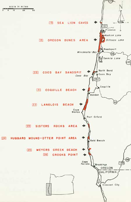
| Oregon — Southern Portion (Vicinity Map) (click on image for an enlargement in a new window) |
19
Sea Lion Caves-Oregon Dunes Area
(Suggested Oregon Coast National Seashore Recreation Area)
Southern Oregon
LOCATION: The sand dunes extend for a distance of 23 miles south of Florence. The Sea Lion Caves area is 12 miles north of Florence.
ACCESSIBILITY: The Coast Highway (U.S. 101) passes through or is adjacent to the entire area.
DESCRIPTION OF AREA: The area comprises 24 miles of shoreline with over 33,000 acres of upland. This includes three distinct types of land forms. Fronting the ocean is an attractive, clean, fine-textured, wide sandy beach. Second is a vast, desert-like expanse of moving sand that has been swept up from the shore by the wind and subsequently deposited and formed into attractive dunes. The third and easternmost type of land form is ancient, forest-covered dunes which reach a maximum height of 450 feet above the sea. Also included are three irregular, freshwater lakes which possess high scenic and recreation values. They vary greatly in size, ranging from 130-acre Cleawox Lake, the smallest, to Woahink Lake with slightly less than 800 acres, and Siltcoos Lake, which covers some 3,200 acres. Vegetative cover is comprised of a dense, picturesque coniferous forest with an understory of varied shrubs and a fine rhododendron display. The Sea Lion Caves site is a notable rookery for Steller sea lions, California sea lions, and bird life of outstanding interest.
PRESENT USE: Present use consists almost solely of recreation. The area includes one 522-acre State park, and there are several developed Forest Service campgrounds and picnic areas. A considerable number of homes and cottages exist around the lakes. The Sea Lion Caves section is managed on a private commercial basis.
ANALYSIS: The area is adjudged to be of national importance, not only for the manifold opportunities for seashore recreation but also for the inspirational worth of the resources to the American citizen. The many superlative values found here are of such high importance as to warrant permanent preservation for the nation as a whole.

|
| Sea Lion Caves and Oregon Dunes Area —Oregon Highway Commission Photos |
20
Coos Bay Sandspit
Southern Oregon
LOCATION: Three miles west of North Bend.
ACCESSIBILITY: By vehicles capable of traveling over soft sand, or by boat.
DESCRIPTION OF AREA: This area, which is the north spit of Coos Bay, extends from the Siuslaw National Forest boundary south to the end of the sandspit. It includes approximately eight miles of ocean frontage. The spit is composed mainly of stabilized or drifting sand. Approximately 80 percent is covered with grass, but only a very small portion supports trees and shrubs. The terrain is flat to gently rolling. The sandy beach along the ocean is very wide, and relatively little sea debris has been deposited above hightide. Razor clams thrive along the beaches on both the bay and ocean side of the sandspit. At the northern limit, and adjacent to the Siuslaw National Forest is a small marsh of approximately one square mile.
PRESENT USE: About 90 percent of the sandspit is public land withdrawn in 1898 for use by the War Department. The remainder is undeveloped private land.
ANALYSIS: This area possesses some fine seashore values, and should be retained in public ownership for recreation and conservation of its natural values. These values will become increasingly important as the nearby towns of North Bend, Coos Bay, Empire, Charleston, and Bayview increase in population.

|
| Coos Bay Sandspit |
21
Coquille Beach
Southern Oregon
LOCATION: Two miles north of Bandon.
ACCESSIBILITY: By automobile over hard surfaced and dirt spur roads from Bandon.
DESCRIPTION OF AREA: The area extends from the southern extremity of the Coquille Sandspit north to Cut Creek. It includes approximately four miles of the seashore of which two miles are public lands. The immediate shoreline is a wide sandy beach with a gently sloping foreshore. Above high tide the beach is approximately 150 feet wide. A considerable amount of sea debris has been deposited upon it. North of the sandspit, second-growth pine and fir occur a distance of from one-half to three-quarters mile inland from the beach. The intervening area is composed of drifting sand and grass-covered dunes.
PRESENT USE: Present use of the area consists mainly of lumbering and ranching, with very limited development. At the southern end of the Coquille Sandspit is an abandoned Coast Guard lighthouse.
ANALYSIS: This area merits consideration as a possible reserve to meet future needs for seashore recreation. The public lands should be retained in public ownership to aid in the accomplishment of this goal when future recreation demands warrant it.

|
| Coquille Beach |
22
Langlois Beach
Southern Oregon
LOCATION: Four miles north of Cape Blanco and three miles south of Bandon.
ACCESSIBILITY: Portions of the area are accessible by automobile on spur roads from U.S. Highway 101. The shoreline is quite inaccessible.
DESCRIPTION OF AREA: The area includes 12 miles of the Oregon Coast. Approximately six miles are in public ownership. The remainder is privately owned. The inland section varies from 1 to 2 miles in width. At the immediate shoreline, and extending along the entire 12 miles, is a wide sandy recreation beach, with a large amount of logs and driftwood above high tide. Within this area are extensive scenic sand dunes ranging in height from 5 to 40 feet. They intrude into a dense forest growth of spruce, alder, fir, and myrtle, occurring in association with pine which predominates the forest. Associated with the woodland are dense thickets of blackberry, salal, rhododendron, and madrone. Gorse is the most conspicuous plant form of the sandy, upper beach area. Many bogs and marshes exist in slight depressions on this relatively flat and low terrain. Also within the area are several scenic but shallow lakes. Some of these are known to possess good salmon and steelhead trout fishing.
PRESENT USE: Portions of the area are lightly-used public lands, while the remainder is privately owned. With the exception of a few small residences, the latter portion is used for ranching.
ANALYSIS: This is a potentially valuable public use area, and should be considered for acquisition as a seashore reserve. The public lands should be retained in public ownership until this can be accomplished.

|
| Langlois Beach |
23
Sisters Rocks Area
Southern Oregon
LOCATION: Twelve miles south of Port Orford.
ACCESSIBILITY: Directly off U.S. Highway 101.
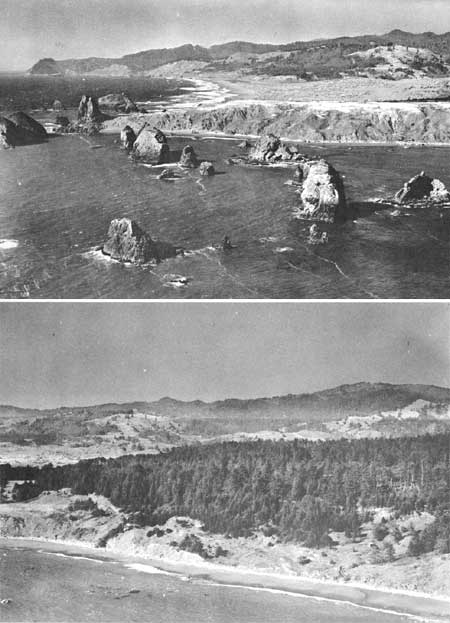
DESCRIPTION OF AREA: Three and three-fourths miles of bold and rugged, scenic shoreline are composed of many offshore rocks, precipitous coastal bluffs, vistas, wooded hills and valleys with occasional small sandy beaches. Fire, logging and road cuts have taken their toll of the natural scene, although enough yet remains to give the area individual character. Included are two prominent points on the shoreline; Sisters Rocks, approximately 395 feet in height, and Lookout Rock, 568 feet.
PRESENT USE: One small commercial development featuring unusual exhibits including objects of natural history is within the area. All of the remaining land is undeveloped. Portions of the tidelands are privately owned.
ANALYSIS: This interesting and scenic portion of the Oregon Coast merits consideration for acquisition for public seashore recreation purposes and for conservation of its remaining natural values.

|
| Sisters Rocks Area |
24
Hubbard Mound-Otter Point Area
Southern Oregon
LOCATION: Three miles north of Gold Beach and 28 miles south of Port Orford.
ACCESSIBILITY: U. S. Highway 101 is adjacent to the area.
DESCRIPTION OF AREA: The Hubbard Mound-Otter Point Area possesses many unusually high scenic qualities. The immediate shoreline has numerous exposed offshore rocks and a narrow but attractive sandy beach at low tide. Above the high tide line is a coastal bluff 50-75 feet high. Further inland, the terrain becomes gently rolling with intermittent flat areas. The area supports a dense growth of hemlock, fir, spruce and pine which extends close to the shoreline. Salal predominates the understory. Both Otter Point and Hubbard Mound serve as excellent seashore vista points.
PRESENT USE: Existing developments are limited to two private residences, and one four-acre State monument. A portion of the tidelands is in private holdings.
ANALYSIS: The area is easily accessible and is adaptable for public recreation use. It possesses many excellent features necessary for this purpose. It is important that It be considered for meeting the needs of the public for areas of this type. The State of Oregon is endeavoring to acquire a portion of the area as a park site.

|
| Hubbard Mount-Otter Point Area |
25
Myers Creek Beach
Southern Oregon
LOCATION: Seven miles south of Gold Beach and immediately south of Cape Sebastian.
ACCESSIBILITY: U. S. Highway 101 traverses the Myers Creek Canyon near the shoreline.
DESCRIPTION OF AREA: The area includes a mile-long section of the Oregon Coast, in conjunction with a scenic, narrow, precipitous and heavily wooded canyon in which Myers Creek meanders to the ocean. This portion of the shoreline has a very gently sloping foreshore, and an unusually wide, attractive sandy beach is available for various seashore activities at low tide. Many rocks of various sizes and shapes are found offshore. Some are accessible by sandbars at low tide.
PRESENT USE: The area is totally undeveloped, but there has been considerable logging in the upper portion of the canyon.
ANALYSIS: Because of the fine beach, interesting offshore rocks, and the undeveloped wooded canyon, the area should be considered for public recreation purposes and for conservation of the natural scene.

|
| Meyers Creek Beach |
26
Crooks Point
Southern Oregon
LOCATION: Fourteen miles south of Gold Beach, and 27 miles north of the Oregon-California state line.
ACCESSIBILITY: The area is adjacent to U. S. Highway 101, although no roads give Immediate access to the shoreline.
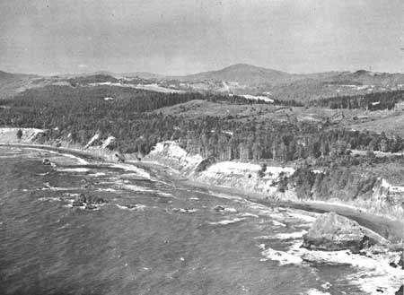
DESCRIPTION OF AREA: This is a four-mile stretch of the Pacific shoreline, possessing a variety of interesting features. From Crooks Point north to Pistol Creek lies an area of large sand dunes adjacent to a wide attractive sandy beach, portions of which are in public domain. Crooks Point itself is a seashore vista for viewing the coast 5 miles north to Cape Sebastian and 10 miles south to Cape Ferrelo. It also overlooks an unusually scenic cluster of protruding rocks immediately offshore. South of Crooks Point to the existing Samuel H. Boardman Wayside State Park, the terrain is relatively gentle in character and supports a dense forest of fir, hemlock, pine, and lesser vegetative ground covers.
PRESENT USE: The sand area is undeveloped except for a few private residences adjacent to the highway. The wooded portion is being used for ranching in addition to the growing and harvesting of timber.
ANALYSIS: The area offers an excellent opportunity to protect unusual scenic qualities and recreation potentialities if acquired for public purposes. Observations indicate that it would be most desirable to acquire certain relatively undisturbed forest-covered slopes and canyons which are inland and adjacent to the existing State Park for preservation of the remaining natural values.

|
| Crooks Point |
| <<< Previous | <<< Contents>>> | Next >>> |
rec_area_survey/pacific/ort2.htm
Last Updated: 25-Jun-2007