|
A History of the Daniel Boone National Forest 1770 - 1970 |
|
CHAPTER XXXIV
NATURAL RESOURCE CONTROVERSY IN KENTUCKY
Kentucky has been a land of controversy from its earliest beginning. First, it was the Indians. The game herds of Kentucky were so abundant that all tribes living to the north and south used it as their hunting grounds. So desirable was it for this purpose that no one tribe dared to claim it as a place to live or as their exclusive hunting ground. Without doubt, many a savage battle was fought between hunting parties of the various tribes in an attempt to protect what each tribe claimed as their own hunting territory. Before the white man came to Kentucky, the condition of continuing controversy existed between the tribes as to which one would use the vast herds of buffalo, elk, deer and wild turkey of the Bluegrass. Only the abundance of these species, providing good hunting for all, prevented open and aggressive warfare between the many tribes claiming hunting rights there.
With the earliest explorations of the interior of America, the land that is now known as Kentucky was claimed by both the French and the English. The French claim was based on exploration of La Salle in 1659, and of Baron Longueil, who explored along the Ohio River in 1739. The English claim was based on the exploration of the Ohio by John Howard in 1742, and by the westward extension of the London Company Charter, which defined no westward boundary of the Virginia colony. Again, there was controversy as to which country would develop the vast natural resources of Kentucky.
Again, in 1775, we find Kentucky involved in controversy. While the Iroquois nation had relinquished all claim to that part of Kentucky south and east of the Ohio River by the Treaty of Fort Stanwix, signed November 5, 1768, the Cherokee nation claimed all of that part of Kentucky south of the Ohio and the Kentucky rivers. When Judge Henderson and the Transylvania Company purchased this land from the Cherokee nation by the Treaty of Sycamore Shoals, signed March 17, 1775, and moved to establish a separate colony there, the Virginia colony again asserted its claim to Kentucky on the basis of the original charter of the London Company. Again, controversy over the ownership of Kentucky and how it would be developed existed.
The first controversy of recent times, involving the factors of natural resources, preservation of forests, local organizations of conservation leaders and the U.S. Forest Service, appears to have started in March of 1935. At that time, E. Lucy Braun, a professor of botany at the University of Cincinnati, presented a talk at the spring meeting of the Garden Club of Kentucky, at Millersburg, Kentucky, on March 29, 1935. The subject of her talk was: Save the Big Trees on Leatherwood, Perry County.
The first paragraph of Miss Braun's talk set the scene for the controversy. It reads as follows, "Down in the southern part of Perry County, on Lynn Fork of Leatherwood Creek, is one of the most beautiful tracts of virgin forest I have ever seen. For some time, I had heard of the Big Poplar of Perry County, and it was while on the quest for this that I saw this magnificent forest. It occupies the Left Fork of Lynn Fork; and, for some two miles, we walked through untouched forest, following a faint trail which led to the Big Poplar, a gigantic tulip tree nearly 24 feet in circumference, breast high. It took five people with arms outstretched to reach around the tree. This gigantic trunk towered upward, unbranched, to such heights that it was impossible to distinguish the leaves of the crown. Nowhere east of California have I seen such a gigantic tree. And this was only one of many large trees.
"The forest contains a variety of trees — tulip trees, oaks, beech, sugar maple, hemlock — all large. Oftentimes, we see tracts of so-called virgin forests, from which this or that tree has been removed; or, if the canopy is intact, with the undergrowth ruined by grazing or by rooting hogs; but, not so here. Nothing has ever disturbed this area; the luxuriance of the undergrowth is beyond description. There is a wealth of herbaceous plants, and beautiful wildflowers and ferns are everywhere. The whole place is awe-inspiring in its beauty and grandeur.
"Very few virgin forest areas remain. Of the original forest of Kentucky, less than two percent remains in such condition that it can be classified as old-growth forest; and only a small part of this is really virgin. The Lynn Fork Forest is one of these."
Miss Braun went on to point out the importance of saving this rare specimen of the primeval forest. She stated, "Nowhere in the whole world is there the equal in beauty and magnificence of our eastern deciduous forest. It is unexcelled. And in Kentucky and Tennessee, this deciduous forest reached its superlative development. By saving a piece of Kentucky's virgin forest, you would be saving a forest outstanding of its kind."
She continued her appeal to the ladies of the Kentucky Garden Club, and she made several suggestions as to how this area might be saved. First, she suggested making the area a state park, but she went on to say that this was not satisfactory because it would be trampled, overrun by picnickers, and the road access and many paths would destroy the primitive wilderness character of the area.
Her second suggestion was to make the area a state forest. Here again, she immediately discounted this suggestion, because state forests are now only managed for the production of timber, and that would defeat the purpose. Her third suggestion, which she indicated as probably the only satisfactory solution, was to include this area within the Cumberland National Forest, and then designate it as a primitive area which would remain forever untouched as an example of America's primitive wilderness. Miss Braun continued, stating, "... if sufficient public opinion were reflected through the Kentucky Representatives and Senators in Congress, they could probably be influential in extending the bounardies of the Cumberland National Forest, so that eventual purchase would be possible. If sufficient pressure is brought to bear — if we want this badly enough — we can get it.
"We must ask quickly before it is cut — the timber rights are held by the Leatherwood Lumber Company, who are now cutting in the next branch. Remember, timber rights and land are held separately, and to secure the land is not to secure the timber." She closes her talk to the State Garden Club with the following statement, "By all means, this project is worthy of your greatest effort. Nowhere, not even in the Great Smoky Mountains, have I seen a more beautiful forest or larger trees. Let us work together to save this area."
On January 6, 1936, Supervisor C. L. Graham of the Cumberland National Forest writes, he had recently attended a meeting at Lexington held under the auspices of the "Save Kentucky's Primeval Forest League." Here, he points out the pros and cons and difficulties of acquisition of this area which, at that time, lay outside the Cumberland National Forest. With his letter, he includes a copy of the program of the meeting, which was held at the Phoenix Hotel in Lexington, Kentucky. Reviewing this program, we find all of the power of the Kentucky State Garden Club assembled behind this project. The President of the State of Kentucky's Primeval Forest League was Miss Daisey Hume of Lexington, Kentucky, one of the most prominent members of the State Garden Club. To give an idea of the level and prestige of this meeting, the principle address was delivered by the Honorable A. B. Chandler, Governor of Kentucky. His address was followed by another talk by the Honorable Tom Wallace, Editor of the Louisville Times newspaper, and one of the principle conservation leaders in Kentucky. Following that, Dr. Lucy Braun, Professor of Botany at the University of Cincinnati, again delivered her stirring address, "Save Kentucky's Primeval Forests." Following her was a 100-ft. movie reel of trees on Lynn Fork of Leatherwood Creek, presented by Mrs. J. Kidwell Grannis, who, at that time, was Chairman of the Leatherwood Conservation Committee of the Garden Club. The program was completed by an address by Dr. Mary Breckinridge, Director, Frontier Nursing Service, Wendover, Kentucky, on the subject, "Conservation of Kentucky's Wildlife." To people familiar with the leaders of conservation in Kentucky in 1936, this was a real powerhouse, manned by all the members of the first team. This group, in 1936, was able to exert approximately the same pressure as could be exerted today by a group which included the Sierra Club, the Audubon Society, and the Izaak Walton League. Appeals from this organization went to Senator Alben W. Barkley, Mrs. Franklin D. Roosevelt, and to the Society for Protection of New Hampshire Forests. An additional appeal directly to the Regional Forester, U.S. Forest Service, by Miss Katherine Pettit of Lexington, Kentucky, another leader in the State Garden Club, elicited the usual, long, government-type letter, in which the process of establishing purchase units, the National Forest Reservation Commission, the availability or lack of availability of public funds, and the time required for the necessary surveys and examinations were pointed out. In reply to a letter of inquiry from the Regional Forester, W. E. Hedges, Chief Land Examiner, Region 7, U.S. Forest Service, replied, "With reference to the interest taken in the establishment of a purchase unit around Lynn Fork of Leatherwood Creek for the purpose of protecting the stand of virgin timber, it is my understanding that the Kentucky River Coal Corporation owns the land which is being held for its coal, and it is not for sale; also, the Leatherwood Lumber Company owns the timber which is now being cut."
The final correspondence in the file on this case of controversy, which indicates a Forest Service connection with it, is written on August 28, 1936, to the Regional Forester of Region 7, by Ira T. Yarnall, Assistant Regional Forester in charge of lands. Mr. Yarnall states, "I know of no authority that the Forest Service has to estimate and appraise the 2,500 acres on Lynn Fork of Leatherwood Creek, which the Save Kentucky's Primeval Forest League desires to preserve by acquiring title to the surface and the present stand of timber. Personally, I do not blame either one of these companies for taking their present attitude, unless they can be assured by the League that it will be in a position to finance the purchase on terms acceptable to the prospective vendors, if and when a meeting of minds occurred." This closes the record of correspondence in this case, and apparently closed the interest and participation of the Forest Service in it. The records indicate that this area of virgin timber was logged by the Leatherwood Lumber Company. Today, Kentucky is the poorer because of the loss of this tract of virgin hardwood.
It is interesting to note the procedure of citizens' groups in 1936, as compared to the activities of similar groups in the late 1960's and 1970's. In 1936, this group, composed of some of the most influential and prominent people in Kentucky, limited its activity to an appeal of its Senator, to the wife of President Roosevelt, and to the U.S. Forest Service. Should the same controversy have arisen in 1965 or later, it is almost certain that the Sierra Club, the National Audubon Society, and the Izaak Walton League would have taken action at the national level; and, if necessary, initiated legal action to stop the cutting of this tract indefinitely. Times certainly do change.
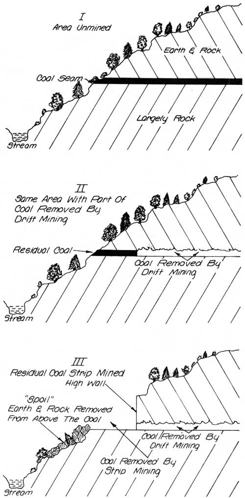
In 1937, the year the Cumberland Purchase Unit was declared a National Forest, the largest single tract to be purchased, the Stearns Coal and Lumber Company tract of approximately 47,000 acres, was acquired. As was the case on most of the land acquired in the southern counties of the Forest, the land was purchased subject to a reservation of the mineral rights by the vendor, and certain rights to operate such minerals, subject to the Rules and Regulations of the Secretary of Agriculture (which provided for watershed protection, clean streams, etc.).
Reduced to simple language, this was a purchase of surface rights only. At that time, strip mining, frequently called surface mining, was generally unknown as a means of coal mining. The coal operations of the Stearns Company and similar operators were based entirely on draft mines. At that time, no difficulty, other than possible erosion from spoil, dump, and acid drainage from the drift mines, was anticipated.
By 1953, many coal operations in southeastern Kentucky had developed a system of surface mining, whereby the edge of the coal seam or the outcrop at the edge of the slope was cleared of the soil and the rock above it, picked up by a power shovel, and loaded directly into huge trucks for transportation to a tipple, where it could be cleaned, graded, and otherwise prepared for market. The width of coal seams which could be so cleared dependent on two factors: the thickness of the coal seam and the steepness of the slope on which the coal outcrops, and the amount of soil and rock which must be removed.
This was usually measured by the height of the high wall, which is a vertical wall of earth and rock left on the mountainside of the strip or cut.
With coal seams in the general area of the Stearns' holdings averaging from 36 inches to as much as 60 inches in thickness, a high wall of as much as 50 feet could be expected on most operations. Since the coal seam on the 47,000 acres of the Stearns mineral ownership outcropped on both sides of most of the hollows or valleys, the total lineal mileage of outcrop was considerable.
Much of the coal under the surface purchased from the Stearns Company had been removed by drift mining during the previous 30 years, leaving, along the edges of the hollows, bands of coal seams varying from 50 to 200 feet in width, where the slope of the hill and the absence of sound rock above had made removal of this edge of the coal seam too dangerous or expensive to remove, due to lack of sound roof for the drift. At the time of this controversy, it was estimated that the Stearns Company owned about 100 lineal miles of drift under the Forest Service surface ownership. It is evident that many thousands of tons of coal, not recoverable by drift mining methods, could be recovered by the new surface or strip mining system.
The Stearns Company had sold their surface ownership to the Forest Service in 1937 at the depth of the depression. This 47,000 acres had all been cut over heavily by the Stearns Company, removing all types and sizes of timber which could be sold or utilized as mine props. In fact, they had induced the government to extend the purchase unit, whose southern boundary had originally been the Cumberland River, south to the Kentucky-Tennessee line, to include their holdings in McCreary County, by offering this large ownership at an attractive price. President Robert Stearns had appeared personally before the National Forest Reservation Commission in Washington to urge the extension of the purchase unit, and to offer his company's land (with mineral rights reserved) at an attractive price.
His request was successful, the purchase unit was extended, and the government purchased the 47,000 acres of the Stearns Company holdings in McCreary County. At the time, the Stearns Company considered this sale as a shrewd business accomplishment. Prior to the sale, they had cut all usable timber, they had retained all mineral rights, including reservations of areas around existing mines, and the right to open new mines. Best of all, they had relieved the company of paying taxes on the 47,000 acres sold to the government. The money received for the land appeared to be clear profit.
By the beginning of the year 1953, the economy had strengthened, as had the price of coal. Coal operators in the general area had begun to utilize the new method of surface recovery or strip mining to recover coal at the edges of outcrops and in valley areas where the overburden was such that the coal operations could yield an economic profit. The Stearns Company, alert to new methods of operation which promised an economic advantage, immediately saw an opportunity to recover the many thousands of tons of desirable coal, previously believed inoperable under the drift method, by strip mining. Early in 1953, preliminary discussions of such operations were initiated with District Ranger Hurst of the Stearns Ranger District, and with Forest Supervisor Borden of the Cumberland National Forest. After a study of strip mining operations in the general area, and noting their adverse effects on the watershed and streams, the Forest Service offered the Stearns Company little encouragement.
In May of 1953, Forest Supervisor Borden retired and was succeeded as Forest Supervisor of the Cumberland National Forest by Robert F. Collins, previously serving in the Division of State and Private Forestry in the Regional Office, Region 7, at Philadelphia, Pennsylvania. Apparently believing that there was a possibility that the new Forest Supervisor might have a different attitude toward the situation, the Stearns Company requested a conference with the Forest Supervisor to discuss the possibility of strip mining on their mineral reservation. It was agreed that the meeting would be held in President Stearns' office on August 12, 1953. The Stearns Company presented its former request in a letter to the Forest Supervisor, dated August 20, 1953. Reduced to fundamentals, this letter requested the administrative permission of the Forest Service to strip mine any place on the 47,000-acre tract purchased from the Stearns Company under authority of the mineral reservation of the deed of December 18, 1937, without reclamation.
After a detailed staff review and analysis of the Stearns Company's request, a copy of the letter was transmitted to the Regional Forester with Supervisor Collins' memorandum of August 28, 1953, which summarized the Forest's analysis of the situation and presented the Cumberland's recommendation as follows:
"In view of the points presented above, it is my firm recommendation that Mr. Stearns be given a negative answer to his proposal, that he be refused permission to undertake strip mining operations on National Forest lands of the Cumberland National Forest, and that this decision be defended in the courts by every legal resource at our disposal."
Needless to say, the Stearns Company's request was the subject of staff review in the Regional Office and of many conferences between the Regional Forester and the Chief's staff in Washington. Legal staff officers of the Assistant to the Solicitor were consulted, and opinions furnished the Chief and the Regional Forester.
On January 29, 1954, Regional Forester Tebbe advised the Stearns Company by letter of that date that he could not approve its request to strip mine the 47,000 acres of National Forest surface ownership without reclamation.
On July 1, 1954, the Stearns Company again requested administrative authority to strip their mineral rights under the 47,000 acres of Forest Service surface ownership, with only such reclamation as was required by the new Kentucky Strip Mine Law which became effective on that date. After adequate staff reconsideration and recommendation, Regional Forester Tebbe wrote the Stearns Company on July 30, 1954, again declining to issue administrative authorization to the Stearns Company to recover the coal from their mineral reservation on the 47,000 acres of National Forest land, completing only such reclamations as were required under Kentucky State law.
On August 29, 1954, Robert L. Stearns, Jr., President of the Stearns Company, appealed in person to the Office of the Secretary of Agriculture, from the decision of Regional Forester Tebbe which denied the application of the Stearns Company to strip mine coal from their reserve minerals on the 47,000 acres of the Cumberland National Forest.
The Secretary of Agriculture, Ezra Taft Benson, proposed that an appeal board, composed of disinterested persons, be designated to: examine the area proposed for strip mining, consider the type of mining operation planned, consider the effect of such mining on other values, explore general public reaction and make recommendations to the Secretary of Agriculture as to appropriate action in this case. This suggestion was concurred in by Mr. Stearns.
In accordance with the agreement, Secretary Benson appointed a three-man group of consultants composed of the following: Charles T. Taft, attorney, Cincinnati, Ohio (brother of Senator Taft); R. L. Wilhelm, mining engineer, St. Clairsville, Ohio; and Samuel T. Dana, former Dean, School of Conservation, University of Michigan, Ann Arbor, Michigan.
On December 13, 1954, this board met at Columbus, Ohio, for the purpose of organizing the board and deciding on a schedule of operation. Charles Taft was elected chairman of the board, and assumed that position for the operation of this group.
During the period of January 24-26, the board visited the area in question, examined the sites proposed for initial stripping operations, examined operations on private lands similar to those proposed on the National Forest, and examined streams and the watershed of these operations to determine the effects of the strip mining on their quality.
On January 27, 1955, the board held a public hearing in a rural school building near Stearns. Despite a wintery day with snow and ice-glazed roads, a large group of interested people participated in the hearing. Many came from Lexington and Louisville, and other distant points. Included in this group were: Tom Wallace, Editor, Louisville Times (former President, National Park Association); Mrs. J. Kidwell Grannis, President, Kentucky Conservation Council; and Richard McArdle, Chief, U.S. Forest Service, along with many others of state and national interest. With the exception of a few local employees of the Stearns Company, all spoke strongly against the approval of strip mining of the National Forest.
Throughout the entire period of the controversy, individuals from many other states wrote the Forest Service, protesting any strip mining of the Cumberland National Forest. One high school class in Pennsylvania wrote that their country and streams had been ruined by strip mining, and they did not want the same thing to happen to the National Forest. Many organizations of all types passed resolutions protesting strip mining of the Forest. All of the major newspapers and many of the smaller ones carried editorials against approval of the Stearns Company's request.
It was quite apparent that the general public was overwhelmingly against the Forest Service yielding to the demands of the Stearns Company that they be permitted to recover the coal deposits of their mineral reservation on the 47,000 acres of National Forest lands by strip mining operations. A topographic map study of the land in question indicated that, if all coal seam outcrops on the land in question were strip mined, a total of over 2,000 linear miles of strip-mined side-hill-cuts could well result. It was repeatedly pointed out to the board that such destructive practice to watersheds was contrary to the purposes of the Weeks Act of March 1, 1911, which was the legal authority under which the land had been purchased.
After detailed study of available information, consultation with the public, field review of strip mine operations on private land similar to the land in question, as well as full consideration of the purpose for which the Cumberland National Forest was acquired and the legal authority on which it was based, the chairman of the board, Charles P. Taft, on May 12, 1955, reported to the Secretary of Agriculture that a majority of the board recommended that the application of the Stearns Company to strip mine the National Forest land in question be denied.
On July 22, 1955, E. L. Peterson, Assistant Secretary of Agriculture, issued the following statement, "Upon examination of the record and consideration of the recommendation of the consultants, it is my conclusion that strip mining of the lands acquired by the United States from the Stearns Coal and Lumber Company in McCreary County, Kentucky, would not be in the public interest; and, the decision of the Regional Forester, denying the application, is affirmed."
The decision of the Department of Agriculture in this appeal was transmitted to the Stearns Company by Assistant Secretary Peterson's letter of July 27, 1955, which reads as follows:
"After a great deal of careful study, I have decided to sustain the denial by the Forest Service of the application of the Stearns Coal and Lumber Company to strip mine the coal on lands in the Cumberland National Forest. I want you to know that this decision was reached only after my personal review of the testimony given at the public hearing at Stearns and the report of the three-man group of consultants appointed to study this matter, and after hearing your comments on the consultants' report. I have tried to give full recognition and proper weight to all aspects of the problem.
"I appreciate that our decision will be a considerable disappointment to you. I regret this. It seems clear to me that my decision must be based on my best judgment of the public interest. Sincerely yours, E. L. Peterson, Assistant Secretary."
In transmitting copies of this decision to the Forest Supervisor and Rangers of Region 7, U.S. Forest Service, on August 4, 1955, Regional Forester Tebbe stated, "This decision is an important milepost in the care and management of National Forest land, particularly in the eastern Forests."
This case attracted nationwide attention, as it was the first time that a vendor, owning reserve mineral deposits under National Forest land, had requested administrative authority to remove those mineral deposits by use of strip-mining methods. This request was further compounded by the fact that the mineral to be removed was coal, which involves the formation of acid drainage due to the sulfur content. Another adverse factor was the steep topography and the instability of the soils of the area, which have a tendency to result in earth slides when wet, even without strip mining. The combination of these adverse factors, when applied to National Forest land, purchased under authority of the Weeks Act of 1911 for the combined purposes of flood control, watershed protection and timber growing, would have resulted in wiping out National Forest benefits for the public.
Since the practice of strip mining as a means of coal recovery was growing rapidly, not only in Kentucky, but in the states of West Virginia, Tennessee, Ohio, Illinois and Pennsylvania, the entire nation was watching the outcome of this case as an indication of the ability of the Forest Service to protect National Forests nationwide.
While the decision of the Department of Agriculture closed this particular case, the personnel of the Cumberland National Forest and the Stearns Company continued to explore the various sites, coal seams and possible methods of strip mining which might permit coal removal by this method without a deteriorating quality of the streams, watersheds, and scenic values. Although much time was spent by the technical personnel of both organizations, both individually and together, in such studies, no situation and method was found which could insure against heavy damage to natural resource values from coal removal by strip mining. As a result of these effort, it became apparent that protection of natural resource values and strip mining by any known method were not compatible in eastern Kentucky.
In all justice, it should be recorded that, throughout this controversy, the attitude of R. L. Stearns, Jr., President of the Stearns Coal and Lumber Company, was friendly and constructive. As president of the company, he was endeavoring to liquidate the mineral ownership of the company in a manner to insure a maximum dividend to its stockholders. His contacts with Forest officers and others involved were gracious and hospitable. This attitude toward the Forest Service prevailed until his death in May of 1965.
Shortly following the decision of the Secretary of Agriculture on the Stearns appeal, the District Ranger of the Stearns District was contacted by a local lawyer for technical information which could be used to defend his clients from having their land strip mined by the Stearns Company against their will. The situation was as follows:
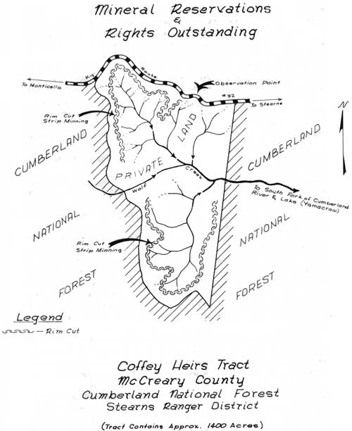
A group of local residents, known as the Coffey Heirs, were the joint owners of a tract of land of about 1,400 acres lying in the drainage of Wolfe Creek, less than two miles above the point at which it empties into the headwaters of Lake Cumberland at Yamacraw. This tract, which was surrounded on three sides by National Forest land and on the fourth side by Ky-92, was of divided ownership typical of much land in McCreary County. The surface was owned by the Coffey Heirs, and the mineral rights by the Stearns Coal and Lumber Company. The surface owners had declined to give the Stearns Company permission to remove their coal by strip mining. The Steams Company had asserted what they claimed to be their rights under their mineral deed, and were preparing to strip mine. The Coffey Heirs had retained the services of a lawyer to defend their surface ownership from destruction by strip mining.
|
| Mineral Reservations & Rights Outstanding (click on image for a PDF version) |
Since this tract was entirely included within the exterior boundaries of the 47,000 acres purchased from the Stearns Company by the Forest Service, and since the conditions existing in this case closely parallelled those in the recently completed Stearns case, it appeared that this might well be a part of a plan to lay a foundation for the Stearns Company to take their appeal, recently denied by the Secretary of Agriculture, to Federal Court.
At the close of the Stearns case, Mr. Stearns had stated that he and his legal advisors, one of whom was Howard Baker, Jr. of Tennessee, now a U.S. Senator and prominent in the Watergate investigation, believed that they could win their case in the Federal Court. After reviewing the facts in the Coffey Heirs case, it appeared possible that the Stearns Company was pressing this case with the hope that the Coffey Heirs would take it to court. It appeared that, if the Stearns Company could win this case in Circuit Court, it would stand as a precedent that, in cases of this type, the mineral rights owner had a legal right to remove his coal by strip mining, regardless of the wishes of the surface owner.
If this could be established, it would follow that the Stearns Company would probably initiate a similar case in the Federal Court, demanding the right to remove its coal from under the surface ownership of the National Forest by strip mining without reclamation, citing the precedent of the Coffey Heirs case in the Circuit Court.
This situation was presented to the Regional Office and the Chief, whose staff discussed it with the Assistant to the Solicitor of U.S.D.A. The possibility that this was a move to establish a precedent for taking the Stearns case to Federal Court was sufficiently strong to convince the Forest Service legal staff that the Forest Service should enter the case as a friend of the Court. This action was initiated promptly, and the technical witnesses, assembled by the Forest Service in the Stearns case, were again assembled at Stearns on the day of the opening of the Coffey Heirs case in Circuit Court at Whitley City.
When Mr. Stearns and his lawyer entered court that morning and saw the assembled legal and technical witnesses which had confronted them at the Appeal Board Hearing, the Stearns Company lawyer immediately requested a conference with the Coffey Heirs lawyer, and later with the judge.
After about two hours' delay, the judge announced that the opposing sides had reached an agreement and that the case was dismissed. The Stearns Company had offered the Coffey Heirs a royalty of 25¢ per ton of coal mined from their tract, and the Coffey Heirs had accepted. The land was strip mined, yielding but little coal and very little revenue for the surface owners. There was no reclamation and, for many years, this strip mined area has been bleeding silt and acid into Wolf Creek, and from there, into the headwaters of the Lake Cumberland.
From the Forest Service standpoint, the action was successful in preventing the Stearns Company from securing a legal precedent for strip mining a mineral ownership without the concurrence of the surface owner.
Beginning about 1967, the Daniel Boone National Forest became involved in the natural resource controversy which has reached proportions claiming national attention at the level of the national press, as well as that of Committees of Congress. This is the controversy over the Red River Dam, the proposed site or sites of which lie within the Daniel Boone National Forest. The involvement of the Forest Service in this controversy is both direct and indirect.
It is often said that it is the innocent bystander who gets shot in the leg. This appears to be the case in the controversy over whether or not there should be a dam on the Red River; and, if so, where?
Briefly, the situation is this. The Red River rises in eastern Kentucky on the Cumberland Plateau, and flows generally westward some 70 or 80 miles to join the Kentucky River in the Bluegrass. About midway in this journey, the Red River drops from the level of the Plateau to the level of the outer Bluegrass over a distance of 12 to 15 miles through a rocky canyon of rare and spectacular beauty known as the Red River Gorge. This portion of the Red River is within the Daniel Boone National Forest. As the River continues westward beyond the Forest to join the Kentucky River some 47 miles distant, it flows through a wide, fertile plain of Bluegrass country, containing some of the best agricultural land in the counties which it traverses. Unfortunately, during periods of high precipitation, the Red River is subject to flooding, particularly the portions downstream from the Forest, which includes within the floodplain the towns of Stanton and Clay City, as well as many rural residents. During the frequent floods, damage to crops, livestock and property is heavy.
For many years, the residents of these downstream counties have petitioned their representatives in Congress for action by the Federal Government to eliminate these costly floods, or at least materially reduce the flood crest.
In response to these requests, the U.S. Army Corps of Engineers initiated studies of the situation as a part of the overall study of the Kentucky River Basin, holding hearings in Hazard and Frankfort in 1954. At this time, local residents specifically requested construction of a flood control dam on the Red River. Such a dam was recommended by the Corps as a part of their report of this study. Both the House of Representatives and the Senate Committees of Congress held hearings on the Kentucky River Report, in which was included a recommendation of the Red River Reservoir. There is no record of any opposition at either of these hearings.
In 1962, the Red River Reservoir was authorized by Congress as a part of the Flood Control Act of that year. In 1963, the Corps of Engineers held a public hearing in Stanton in March to inform residents of the area of the extent and nature of the project. Approximately 200 people attended this hearing, none of which expressed views opposed to the Red River project.
In August of 1967, at a hearing at Stanton to inform the people of the area of the procedure to be followed in acquiring land needed for the project, the Cumberland Chapter of the Sierra Club, organized the previous February, registered their formal opposition to the project on the grounds that development within the Red River Gorge would destroy the scenic and natural values of that area. They maintained that the Red River Gorge should be held inviolate.
The Corps of Engineers' study had included, among other values, those of hydraulic, economic, aesthetic and recreation factors. One of the conclusions expressed was that the scenic attributes of the area would be made accessible to a greater number of people than now used the area by the construction of the Red River Reservoir. The Corps' study also concluded that, while many alternative projects to provide the same end-product had been considered, none were determined to be as functionally efficient nor as economically feasible as the multiple-purpose Red River Reservoir. The study also provided convincing evidence that the Red River Reservoir is essential in meeting the water resource needs of the area.
The Corps pointed out that every reasonable effort would be made to protect and enhance the scenic beauty of the area. To that end, they invited the Sierra Club to submit suggestions as to how protection and enhancement of scenic and environmental values could best be achieved in combination with the reservoir construction.
With the authorization of the Red River Reservoir in 1962, and the initial funding for study, the Daniel Boone National Forest made a review of the potential for such a project to enhance or damage the natural resourcement environment of that portion of the Forest. This study recognized several possibilities; but, until a specific site was selected for the dam and flood and pool levels proposed for the reservoir specific, evaluation was limited.
Needless to say, the Forest Service was pressed from all sides to take a position in the controversy. When the initial damsite was announced as just below the mouth of Indian Creek, with a pool elevation of 725 feet, a flood pool of 807 feet and a seasonal pool of 767 feet above sea level, respectively, this provided specific data on which to evaluate the impact of the project on the National Forest land evolved.
Initial studies indicated that about 2,000 acres of National Forest land and 1,400 acres of private land would be flooded at the flood pool level. In addition, about 8,000 acres of National Forest land and 2,000 acres of private land would be affected by the management and public use of the reservoir.
An evaluation of anticipated impact indicated the following factors:
Geology — The general area surrounding the proposed reservoir, containing 23 known, large, natural rock arches or bridges, many miles of spectacular cliff lines towering 250-300 feet above the Gorge floor, and individual rock formations, such as Courthouse Rock, rising 520 feet above the Red River, make the natural geologic scenery outstanding throughout this part of Kentucky.
Fortunately, with the exception of one minor arch (Moonshiner's Arch), no other significant rock formation would be reached by the flood pool proposed, nor would the vegetation around them be killed. It was estimated that flood waters might reach the base of Moonshiner's Arch one year out of five or 10, and would not damage it.
Ecology — It was accepted that the vegetation of the area actually flooded would be destroyed. This was not considered a major loss, as over half of such area had been cleared for farming at some time in the past. Although both the Sierra Club and the Audubon Society made impassioned pleas that the ecology so destroyed was unique and occurred nowhere else in the area, repeated challenges to provide proof of this point remained unanswered by either organization. No unbiased studies were presented nor specific species or associations of plants pointed out to substantiate this point. Since most of the area to be flooded was frequently covered by the annual flood waters, the vegetation was largely the plant association normally associated with sand bars and silt beds. In summary, the National Forest analysis failed to disclose any threat of a major ecological loss from the proposed reservoir.
Water — At the time of the study, the portion of the Red River involved in the project was not the unpolluted, crystal-clear, white-water stream pictured in the claims of the Sierra Club. During most of the year, the stream carried a heavy silt load derived from the agricultural lands and unstabilized road fills of the area upstream from the Gorge, as well as raw sewage and debris from the Campton area. By comparison, the study rated the Red River below the Rockcastle, the Big South Fork and the Upper Cumberland as a white-water stream.
Fish and Wildlife — While the project would eliminate stream habitat conditions in the portion flooded, it would substitute a lake fishery habitat, stocked with large-mouthed bass, walleye, and muskellunge from the new State Hatchery below the Cave Run Dam, less than a dozen miles distant. In general, the quality of the fishery could be expected to improve with the reservoir in place.
Road Access and Recreation Improvement — As the Daniel Boone National Forest had long protected the Red River Gorge as a unique area from which roads and permanent recreation development had been excluded, no improvements of this type would be lost. Ky-715, paralleling the river downstream from Sky Bridge, would be lost. In view of the impact of high-density use of such an area by the public, this loss of road access into the Gorge could well be counted as a gain for the ecological resource. Ky-77, from Nada to Frenchburg, could well be relocated to cross the Gorge on a high bridge.
Future Development — With the reservoir in place, its unique ecological setting and wilderness atmosphere could well be protected by limiting access to hand-propelled boats on the water and foot trails by land. Such improvements as campgrounds and parking areas would be restricted to adjacent National Forest land and well screened from the Gorge itself.
Summary — The study of the Red River Gorge Reservoir by the staff of the Daniel Boone National Forest disclosed no major impact on the general ecology, scenic value, sport fishery, water quality or administrative improvement. On completion of the reservoir, the Daniel Boone National Forest would develop plans to protect its natural features and develop on nearby National Forest land facilities to accommodate public demand without contributing to the deterioration of the wilderness atmosphere of the reservoir and surrounding scenic natural features.
With the authorization of the Red River Dam and the allocation of planning and construction funds by Congress, the people of Lexington, Powell County, and the Red River Valley assumed that the dam was assured and that its construction was only a matter of time. With the formal opposition to the dam by the Sierra Club at the August, 1967, hearing at Stanton, these people, who had worked so long for the dam and the flood control which it would provide, were outraged. They voiced their opposition to the bird watchers, all of whom live well outside the floodplain of the Red River, who opposed the dam. A major controversy was established, which has not been reconciled to this day (1976).
The Sierra Club enlisted the aid of the National Audubon Society in its campaign to "Stop The Dam." They attempted to enlist the League of Kentucky Sportsmen, the National Wildlife Federation, the Kentucky Conservation Council and other conservation organizations to support them, but without success. The Cumberland Chapter of the Sierra Club, supported by the national organization, embarked on a national campaign of letter-writing, personal contacts with key political figures, and meetings featuring prominent, self-styled conservationists and ecologists.
On Saturday, November 18, 1967, the National Office of the Sierra Club induced Supreme Court Justice William O. Douglas to visit the Red River Gorge briefly, and to serve as a speaker for their meeting in Lexington that evening. The local residents in favor of the dam, who had formed the Red River Dam Association, also met Justice Douglas when he arrived in the Gorge to make a short walk from the highway to Moonshiner's Arch and return. They let the Sierra Club and Justice Douglas know how they felt about the dam and the opposition to it. Only the presence of a detail of State Police prevented actual physical opposition.
Throughout this controversy, the Forest Service, both at the national level and at the Daniel Boone National Forest level, was challenged to speak out and take a position on the situation. Many organizations, such as the National Wildlife Federation, the League of Kentucky Sportsmen, the Kentucky Conservation Council, members of the Governor's staff, and similar groups came to the Forest Service for factual information and for a tour of the project area. After they had not been able to substantiate for themselves the extravagant claims of the opponents of the dam, while it was gratifying to have these people demonstrate their confidence in the Forest Service, it also put the Forest Service on the spot as to their position in the matter.
In December of 1967, the Forest Supervisor of the Daniel Boone National Forest, after conferring at length with the Regional Forester to insure firmness of policy, announced the position of the Forest Service essentially as follows: "This is a project of the Corps of Engineers, authorized and funded by Congress. The Forest Service is a Government agency, and we fully support this project." This cleared the air as to where the Forest Service stood in the controversy.
The controversy continued throughout 1968, in the public press and even in the halls of Congress, where Kentucky's Senior Senator John S. Cooper took a position against the Red River Dam, while Kentucky Congressman Carl Perkins urged its construction to provide flood protection for the people within his District. In July of 1968, Senator Cooper proposed that the Red River Dam be constructed at an alternate site some 5.5 miles further downstream from the original site, and just above the junction of the main Red River with the Middle Fork; and, at the same time, lowering the spillway height to reduce the pool levels in the Gorge. This suggestion offered all parties an opportunity to escape the stalemate into which the controversy had developed.
In April, 1969, Governor Louie B. Nunn, after conferring with Dr. Elvis Stahr, President of the National Audubon Society, which had been supporting the Sierra Club in its opposition to the dam, announced that he could not approve the construction of the Red River Dam at the original site. This brought all planning on the project to a halt, as the Corps of Engineers have never constructed a dam at a site not approved by the Governor of the state in which the site was located.
At about this time, a letter to the Editor of the Louisville Courier-Journal pointed out that Dr. Elvis Stahr, as Secretary of the Army in 1962, had signed the letter of transmittal for the Kentucky River Report, which recommended the authorization of the Red River Dam. Acting on this recommendation, Congress authorized the project. Now, in 1969, as President of the National Audubon Society, Dr. Stahr was opposing the construction of this dam. It was obvious that Dr. Stahr's viewpoint had changed.
At about this time, Senator Cooper appealed to President Richard M. Nixon to save the Red River Gorge by supporting the move to construct the dam at the alternative site.
On April 10, 1969, the New York Times, under the heading, "Victory At Red River," published the following: "The decision of the Nixon administration against building a dam in the Red River Gorge of Eastern Kentucky is a notable triumph for citizen conservationists. A beautiful and scientifically interesting wilderness valley has been saved from drowning and an important principle established.
"It is rare, if not unprecedented, for the Army Corps of Engineers to drop a project, once it has received Congressional authorization and appropriations. But, a new breed of conservationists has appeared in Kentucky and elsewhere on the American scene, and has proven that even the most impenetrable bureaucracy can be made to yield. Outsiders like Justice William O. Douglas, who led a protest hike along the Gorge two years ago, provided the local people with valuable help."
Time Magazine, in its issue of April 11, 1969 states, "The cement pourers have been thwarted on dam projects before, but rarely — if ever — on such ecological and aesthetic grounds. What rescued the Red River Gorge was frenzied activity by the Sierra Club and the Audubon Society, an outpouring of statements by Kentucky biologists, and, most important, intervention by some high-level Republicans, including Governor Louie Nunn, Senator John Sherman Cooper and President Richard Nixon."
Glenn O. Rutherford, writing in the February, 1972, issue of American Forest Magazine, somewhat sums up, in a prophetic manner, what has happened to the Gorge in recent years. He writes, "By the late 1960's, people swarmed over the Gorge, from the top of Chimney Rock to the depths of hollows crowded with giant hemlock, tulip poplars, sycamores, beeches, hickories and oaks. They came with packs on their backs and in $15,000 camping vehicles. They came to see the place the Army was going to destroy with water — and in doing so, they succeeded in destroying much of it themselves."
Finally, after over a year of study and preliminary design, the Corps of Engineers announced in April of 1971, that it was recommending that the Red River Dam be constructed at the alternate site.
At this writing the controversy continues, with the Sierra Club continuing to question whether or not any dam should be constructed in the Red River Gorge. The Corps of Engineers is holding additional hearings in an attempt to determine the desires of the people. The Sierra Club and other opponents of the dam have now been joined by a recently organized group of Powell County residents known as Save Our Red River (S.O.R.R.). The basis of opposition of this group is not ecological, but is a protest against a large number of homesites, prime agricultural land, productive timber, and unique recreation areas which will be lost, if the reservoir is constructed. In addition, this group believes that the proposed reservoir will prove to be unsightly, due to large areas of mud flats resulting from fluctuating water levels.
It appears that this controversy is far from being resolved, and that the Daniel Boone National Forest is still literally in the middle.
As a result of the involvement of the Cumberland Chapter of the Sierra Club in the Red River Gorge controversy, that organization assumed the position of watchdog over all of the National Forest land located within the drainage of the Red River.
To implement this role, the Sierra Club concentrated its outdoor activities on the Gorge area. Its canoeing outings featured trips down a stretch of the Red River which laid within the Gorge. Overnight camping meetings concentrated on the use of the Forest Service camp area at Koomer's Ridge. Hiking outings concentrated on the National Forest trails adjacent to the Red River Gorge. Throughout these field expeditions, each Sierra Club member considered himself or herself a fully qualified inspector of environmental administration of the National Forest with a mission of checking up on Forest Service activities. It is significant that little or no attention was paid to the administration of privately owned land intermingled with Forest Service land within the Gorge area.
Late in February of 1969, the Forest Supervisor of the Daniel Boone National Forest received a telephone call from a member of the Executive Committee of the Cumberland Chapter of the Sierra Club. This member informed the Forest Supervisor that his organization had discovered a Forest Service timber sale in the Red River Gorge. The Forest Supervisor assured him that there were no Forest Service timber sales in the Gorge, and asked the location of the cutting referred to. On being informed that it was located at the head of Reffitt's Branch, just east of Ky-715, the Forest Supervisor readily acknowledged that it was a Forest Service timber sale, whose purpose was primarily the regeneration of a new hardwood stand by releasing sprouts of white oak, tulip poplar, hickory and hemlock through a cutting of the remnants of undesirable trees of poor species, form and defect left by the logging operations of many years before. The sale would result in the salvage of those trees, containing some merchantable material, and the release of the young growth already present. He also pointed out that the sale area was not in the Gorge, but over three miles from it as the crow flies, and about five miles distance by stream, and located on the plateau above the Gorge. This explanation was completely unsatisfactory to the Sierra Club representative, who informed the Forest Supervisor that his organization insisted that all such sales in the entire Gorge area (Red River Drainage) be suspended at once, pending an investigation by the Sierra Club. The Forest Supervisor assured him that he and other representatives of the Sierra Club would be welcome to meet with the Supervisor and his staff on the matter, and that a Forest officer would be glad to accompany them on a field trip over the sale area. He also advised that the timber sale in question had been in progress for over a year, and still had about a year to run; also, that the merchantable timber on the area was now the property of the permittee, and that the sale could not be cancelled or even shut down, except for violation of the timber sale contract by the operator. This information did not appear to be satisfactory to the caller.
Within a few days, the Forest Supervisor received a letter, dated March 3, 1969, and signed by the Chairman of the Cumberland Chapter of the Sierra Club, which contained the following points: it expressed extreme concern over the timber cutting activity which the Club had "discovered" in the Red River Gorge area during the previous week, it stated, "We are requesting that timber cutting be suspended immediately in and near the Gorge area, pending a decision as to the ultimate use and administration of the area," and it stated that the Cumberland Chapter of the Sierra Club was excelerating its effort to define a position regarding the ultimate use, administration, and boundaries of what they hoped would remain an outstanding example of Kentucky wilderness in the Red River Gorge.
After checking the details of the timber sale in question, and discussing the situation with the Ranger and staff officers concerned, the Forest Supervisor replied to the Sierra Club letter on March 7, 1969. The essence of his reply was as follows.
The sale referred to was one of many then in progress on the Daniel Boone National Forest.
The National Forests were managed under the principle and policy of the Multiple Use Act of 1960.
The main Red River Gorge and tributaries, below the cliffs, were delineated in the Multiple Use Plan for the Forest as areas of special scenic, geological, ecological and recreational value; and management prescriptions had been established that would protect and enhance these values.
Above the cliffs, the area had been delineated into zones providing for special management to enhance recreation development, roadside and trail-side protection, special scenic features, and for management to fully utilize the timber and wildlife resources and to make them fully productive.
The management decision involving the area surrounding the Gorge had been made by professional personnel of the U.S. Forest Service, qualified by technical training and their competence proven by years of experience.
These decisions were in keeping with the Multiple Use Act, the Multiple Use Plan for the Daniel Boone National Forest, and with the principles of sound natural resource management.
The decisions which resulted in the timber sale in question were in conformity with the above guidelines.
The timber on the area had been marked, advertised and sold under established timber sale procedures.
The timber sale was within the multiple use zone providing for the management of the timber resource. The purpose of the sale was to regenerate a new timber stand.
The Forest Supervisor is responsible for the administration and management of the Daniel Boone National Forest. He meets this responsibility by managing the National Forest in conformity with the policies and regulations of the United States Forest Service.
In view of this responsibility, he could not honor the Sierra Club request that the timber cutting in the area be suspended immediately.
The recommendations, mentioned in the Sierra Club letter, would be reviewed with interest and given every consideration.
A new phase of the Red River Gorge controversy had been established. The press quickly picked up the issue and expanded it with bold headlines. Fortunately, the Daniel Boone National Forest had maintained a working relationship with the press. When a call for information on this subject was received from the Louisville Courier-Journal newspaper, they were invited to send a staff writer to the Forest, which they did. This resulted in an accurate news story in the Sunday, March 9, 1969, edition, which presented the facts in good perspective.
Several members of the Executive Committee of the Cumberland Chapter of the Sierra Club accepted the invitation of the Forest Supervisor to meet with the Forest staff for a full-scale discussion of the timber sale, and of the Forest policies regarding timber cutting on Forest Service land throughout the entire drainage of the Red River. At the same time, the National Office of the Sierra Club contacted the Office of the Chief of the Forest Service in Washington, with the demand that the Reffitt's Branch Timber Sale be cancelled. On being told the timber belonged to the purchaser, the Sierra Club requested a copy of the sale contract and supporting papers for examination by their lawyers. This information was furnished promptly; and, after lengthy discussions, they agreed that closing the sale by the Forest Service was not legally feasible.
The next step taken by the Sierra Club was to approach the operator and request that he discontinue operating the timber sale. He agreed to do this, providing the Sierra Club would reimburse him for the stumpage he would leave uncut, plus his profit margin for this volume of timber. This the Sierra Club declined to do, so the timber sale was completed according to contract.
In the meantime, members of the local Executive Committee continued to meet with the Forest Supervisor and staff, and to press for having the entire drainage of the Red River inside the National Forest boundary established as a Wilderness Area or similar special area with restricted cutting and specialized administration. At the same time, the Sierra Club was writing and contacting Senators and Congressmen to bring pressure on the Forest Service for a special area classification. As the controversy on the Red River Dam was a matter of national news and Congressional discussion at this time, pressure on the Forest Service at the Washington level continued to increase.
In January of 1970, the Louisville-Courier Journal newspaper again sent a staff writer to the Forest for a field trip to the area in question. Again, a factual and accurate news story resulted.
At this time, it became clear that the Sierra Club had sufficient support at the Washington level to enable them to harrass and embarrass the Forest Service over this issue indefinitely, regardless of the justification the Daniel Boone National Forest had for their management and administrative practices. The Sierra Club and the Audubon Society were proposing that the entire area be removed from the jurisdiction of the Forest Service and made a National Park or a Wilderness, neither of which was justifiable or feasible.
Early in 1970, the Forest Supervisor of the Daniel Boone National Forest, after conferring with the Regional Forester to insure conformance to policy, issued a directive that a complete study of the entire Red River Gorge area would be undertaken to determine how the special features of the area could best be protected and administered to render a maximum of service and enjoyment to people. The directive also suspended all timber operations of every type, including timber sales, timber stand improvement, and any other timber cutting operation, during the planning period. Thus, the Sierra Club had obtained their objective for the time being.
At this writing in 1976, the planning and production of reports on this area are continuing, as is the suspension of any timber cutting operation throughout the Stanton Ranger District of the Daniel Boone National Forest. As pointed out above, the Red River Dam question is still not resolved, and the Corps of Engineers continues to hold public hearings in an effort to bring that question to a head. The entire controversy, like a cat with nine lives, continues to rise up again and again, each time after it appears to have been resolved. Foresters, engineers and administrators are at the mercy of the politicians.
A public hearing on the proposed Forest Service Environmental Statement for the management of the Red River Gorge Unit of some 40,000 acres was held at Stanton, Kentucky, on September 7, 1973. At this hearing, the Sierra Club demanded that the entire 40,000 acres be established as a "no-cutting" unit.
| <<< Previous | <<< Contents>>> | Next >>> |
|
region/8/daniel-boone/hsitory/chap34.htm Last Updated: 07-Apr-2010 |